Here is some weather history for Christmas Eve and Christmas day at Grand Rapids. The average H/L for both days is 34/23. For Christmas Eve the Coldest highs on record are 7 in 1983, 13 in 1989, 14 in 1990, 16 in 2004, 17 in 2022, 19 in 2013 and 20 in 1969. The coldest lows are -9 in 1944, -8 in 1969, -7 in 1999, -5 in 1897, -4 in 1989, and 0 in 2004,1989 and 1983. The warmest highs for any December 24th are 59 in 2012, 58 in 1893, 57 in 1932, 56 in 1982 and 1895. 52 in 1979 and 52 in 1936. The warmest minimum 50 in 1982, 39 in 2015 and 1979. 37 in 1936 and 1932 and 35 in 1931. The wettest (all rain) 1.79” in 1979, 0.89 in 2014, 0.85” (0.6” snow) in 1965 and 0.53” all rain in 1932. The most snowfall on Christmas Eve at Grand Rapids 10.5” in 2022, 7.5” in 1993, 4.5” in 1914, 3.7” in 2001 and 3.5” in 1931. The most on the ground 19” in 1951, 17” in 2008, 15” in 2000, 14” in 2022, 12” in 1916 and 10” in 1983 and 1929.
Some weather history for Christmas day at Grand Rapids. Coldest highs 10 in 1983, 11 in 1924, 14 in 1985 and 1968, 15 in 2004 and 16 in 1950. The coldest lows -3 in 1983, 1 in 2004 and 1968, 2 in 1985, 3 in 1980 and 4 in 1924. The warmest highs 65 in 1982, 57 in 1893, 55 in 2019, 52 in 2021, 50 in 1936 and 49 in 1940,1932 and 1895. The warmest lows for Christmas are 43 in 1936, 42 in 1940, 40 in 1982, 34 in 2005 and 33 in 2021, 1932 and 1922. The wettest are 1.01” (all rain) in 1982, 0.96” in 1936, 0.59” in 1893 and 0.57” in 1993. The most snowfall on Christmas at Grand Rapids 7.0” 2017, 7.0” 1990, 6.7” 2001, 6.5” 1951 and 6.0” in 1965. The most snow on the ground at 7 AM on Christmas morning in 22” in 1951, 17” in 2022, 16” in 2000, 13” in 2008, 11” in 1909 and 10” in 1893.
We are in the biggest snowfall droughts in Grand Rapids history. There is a chance for some snow towards next weekend but so far this December Grand Rapids has only had 1.3” of snowfall if that holds until the end of the month this will be the 2nd lowest snowfall totals for any December at Grand Rapids and even worse is that for the season Grand Rapids is at just 3.2” of snowfall and if that holds for the rest of December that will be the lowest for any start of the winter season at Grand Rapids. The lowest seasonal snowfall total at Grand Rapids is a reported 20” in winter of 1905/06 with 30” the 2nd lowest total and this winter is less than both of those winters at this time.
The official H/L at Grand Rapids yesterday was 42/38 there was 0.26” of rainfall. Once again there was no sunshine. For today the average H/L is 34/23 the record high of 60 was set in 2015 and the record low of -11 was set in 1989. The wettest was in 1932 with 1.02” of rainfall. Last year was the snowiest with a H/L of 15/5 and 7.5” of snow fall. The most on the ground was 19” in 1951.
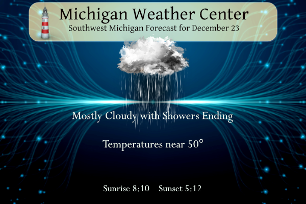
AREA FORECAST DISCUSSION
NATIONAL WEATHER SERVICE GRAND RAPIDS MI
302 AM EST SAT DEC 23 2023

LATEST UPDATE...
SHORT TERM/LONG TERM/MARINE

SHORT TERM
(TODAY THROUGH SUNDAY)
ISSUED AT 302 AM EST SAT DEC 23 2023

STEADY LIGHT TO MODERATE RAIN CONTINUES ACROSS MOST OF OUR AREA
EARLY THIS MORNING. RGNL RADAR TRENDS CORROBORATED WITH A
CONSENSUS OF LATEST HIGH RES MODEL GUIDANCE AND 00Z HREF ENSEMBLES
ALL SUGGEST THAT THIS BATCH OF STEADIER RAIN WILL EXIT OUR AREA
FROM WEST TO EAST BETWEEN AROUND 09Z AND 13Z. HOWEVER WE EXPECT
THAT SOME LIGHTER RAIN SHOWERS AND AREAS OF DRIZZLE WILL LINGER
THROUGH THE DAY ALONG WITH LINGERING PATCHY FOG.

MODEL FCST SOUNDINGS SHOW ABUNDANT LOW LEVEL MOISTURE WILL LINGER
TONIGHT. WE EXPECT PATCHY DRIZZLE TO CONTINUE TONIGHT ALONG WITH
AREAS OF FOG AS BOUNDARY LAYER WINDS WILL BE VERY LIGHT. ON SUNDAY
WE EXPECT PATCHY DRIZZLE TO TAPER OFF AND THE SLOW MODERATING
TREND OF TEMPS WILL CONTINUE WITH HIGHS REACHING THE UPPER 40S TO
LOWER 50S.

LONG TERM
(SUNDAY NIGHT THROUGH FRIDAY)
ISSUED AT 302 AM EST SAT DEC 23 2023

THE LONG TERM PORTION OF THE FORECAST GENERALLY REMAINS UNCHANGED
WITH REGARDS TO THE BIG PICTURE. WE ARE GENERALLY LOOKING AT A
WIDESPREAD RAIN EVENT LATE CHRISTMAS DAY INTO TUESDAY WITH VERY WARM
TEMPERATURES FOR DECEMBER STANDARDS. UNSETTLED CONDITIONS CAN THEN
BE EXPECTED FROM WEDNESDAY AND BEYOND, WITH COOLER TEMPERATURES
BRINGING IN SOME SNOW CHANCES FOR LATER IN THE PERIOD.

WE SHOULD SEE A BREAK IN THE RAINFALL AT THE BEGINNING OF THE LONG
TERM SUNDAY NIGHT AND CONTINUING INTO EARLY MONDAY. WE MAY EVEN SEE
SOME BREAKS IN THE CLOUDS AS HIGH PRESSURE WILL BE OVER THE AREA,
AND THE LOW LEVEL FLOW TEMPORARILY SHIFTS AWAY FROM THE GULF TO COME
FROM THE SE. BY LATER CHRISTMAS DAY, WE WILL SEE THE UPPER LOW
COMPLEX MOVE OVER THE PLAINS, AND STRENGTHEN THE SOUTHERLY FLOW FROM
THE GULF ONCE AGAIN. THE LOW LEVEL JET WILL NOSE INTO THE AREA
MONDAY AFTERNOON AND HELP TO SPREAD WIDESPREAD RAIN ACROSS THE AREA
FROM SOUTH TO NORTH.

THIS BATCH WILL MOVE OUT, AND ANOTHER BATCH WILL MOVE IN ON TUESDAY
AS THE COLD FRONT LIFTS NE UP INTO THE AREA. CONTINUED WARM AND
MOIST SOUTHERLY FLOW WILL SUPPORT THE RAIN AS THE FRONT MOVES
THROUGH. WE CONTINUE TO HOLD THUNDER CHANCES OUT OF THE FORECAST AS
THE CHANCES REMAIN TOO LOW AT THIS TIME TO INCLUDE IN. IT APPEARS
THAT SUFFICIENT INSTAB ILITY CREEPING NORTH ALONG THE FRONT WILL NOT
ARRIVE THIS FAR NORTH UNTIL THE FRONT HAS ALREADY MOVED THROUGH. WE
WILL CONTINUE TO MONITOR THE POTENTIAL OF ADDING THUNDER CHANCES IF
THE FRONT SLOWS DOWN ENOUGH.

THE WARMER TEMPS FROM SUNDAY THROUGH TUESDAY WILL COME TO AN END ON
WEDNESDAY BEHIND THE COLD FRONT. EVEN THOUGH THE FRONT MOVES
THROUGH, RAIN SHOWER CHANCES WILL CONTINUE FOR WEDNESDAY AND BEYOND
AS THE UPPER LOW COMPLEX STAYS OVER THE REGION. SHORT WAVES MOVING
AROUND THE LOW, AND INSTABILITY UNDER THE COLD POOL ALOFT WILL HELP
TO FACILITATE THE RAIN CHANCES.

EVENTUALLY THE RAIN CHANCES WILL MIX WITH, AND CHANGE OVER TO SNOW
CHANCES THROUGH FRIDAY. THE EXACT TIMING OF THIS TRANSITION IN P-
TYPES IS STILL UNCERTAIN AS IT WILL DEPEND ON THE NORTHERN STREAM
WAVE THAT DIVES SE AND PHASES WITH THE MAIN UPPER LOW WHICH HAS
SOUTHERN STREAM ORIGINS. THE NORTHERN WAVE WILL INJECT SOME COLD
ENOUGH AIR TO MAKE THE TRANSITION TO SNOW HAPPEN. A LOT OF
UNCERTAINTY EXISTS AS TO PLACEMENT OF THE BEST SNOW SHOWERS AND
AMOUNTS WITH THE INTERACTIONS OF THE SYSTEMS, AND THE COMPLICATED
WIND FLOW THAT WILL HELP PROVIDE SOME LAKE ENHANCEMENT.
Global Warming is fantastic!!!! This winter has been AWESOME! Keep the warmth going!!!
Best part of this afternoons discussion! Bring it!
Bottom line: Enjoy the unusual warmth while it lasts – there are some indications that we might finally be starting to see some more typical winter weather in our future.
I would consider any sustained Winter weather that doesn’t start till sometime in January or later a win.
Maybe we can keep it rolling through all of March and make up for a snowless December! That would be great!
To each their own!
Sounds great and even if we see multiple snowstorms and over 60 inches of snow some of the warm weather nuts will say we didn’t have much winter! They are in denial every single winter! It has been happening for years! Last year for example we had over 100 inches of snow and they said not much of a winter! Incredible delusion!
Interesting read on our warming winters:
https://www.cnn.com/2023/12/21/weather/us-winter-temperatures-climate-change/index.html
That is an interesting read, especially he fact that cold snaps here in the US are now on average 6 days shorter than during the 70’s and the fact that we are now breaking warm and heat records at twice the pace of any cold records. It’s been great with the savings on heating and plowing!
Jesse mentioned ice fishing yesterday. It’s probably been eight years since I’ve fished through the ice. The ice just hasn’t been thick enough for my liking.
I just saw wisconsins ice fishing season last year was 51 days shorter than the average in the 70s. And this year is on track for even less ice fishing days. I would think Michigan has a similar trend.
That is just remarkable. Wow.
Pretty remarkable when the overnight low is about 10 degrees higher than the average daytime high. Let’s hope these El Niño effects last right on through about April! That would be the perfect Winter with maybe an inch or two of snow per month.
In your dreams! There is absolutely no chance of that happening!
Well I’m pretty sure that neither you or anyone else can foretell exactly what is going to happen, so that leaves the chance of pretty much anything happening.
Wrong! There is no chance your prediction will happen! Impossible!
Where did I make a prediction? I mentioned the word “hope”, no where near a prediction. Why do you insist on making an argument out of everything?
I only point out when comments are totally riducoulus!
Foggy, drizzly, wet, and mild here. I read that 87% of the continental US is having a green Christmas this year.
The Christmas blizzard was 1 year ago from today, pretty crazy storm! This year is sure different… basically made it through all of November and December without any snow
Well, some of us has snow in November for about 2 days…but not like last year ..
Happy Birthday to MV’s wife!!
Happy birthday, Mrs. VanLent!
Who in their right mind would want rain and global warming on Christmas? Bring on a snowstorm baby!