Our climate has changed a lot over the years due to agriculture and the cattle raised for our food sources. One acre of corn can release 4,000 gallons of water per day, enough to fill a residential swimming pool in less than a week. The additional moisture from corn causes higher heat indexes — a measure of how hot it feels taking humidity into account. Add this to the thousands of acres of soybeans and other ground crops into the mix we have higher moisture content in the air which mixes into the atmosphere thus high humidity and increases in severe weather.
When ruminant animals such as goats, sheep, and especially cattle digest their food, it gets processed in their systems through fermentation. This process breaks the food down over time and produces methane, a powerful greenhouse gas that contributes to our rapidly warming planet when expelled to the atmosphere in the traditional biologic routes; i.e., flatulence or burps. Researchers have found that 37% of methane emissions from human activity are the direct result of our livestock and agricultural practices.
The problem becomes more apparent considering the sheer scale of livestock raised for meat production worldwide. A single cow produces between 154 to 264 pounds of methane gas per year. Not counting for the emissions of any other livestock, 1.5 billion cattle, raised specifically for meat production worldwide, emit at least 231 billion pounds of methane into the methane into the atmosphere each year. Because methane is such a potent greenhouse gas, there is great interest in curbing its production. A number of companies and start-ups are investing in plant-based products that mimic meat’s flavor and texture, while others focus on lab-grown alternatives, both of which would lessen the need for animal farms and their associated emissions if more widely adopted.
To sum it up, we tend to blame our cars for being the cause of major pollution we have to look at the big picture, the matter of our survival to eat, to feed eight billion people.
More to come!
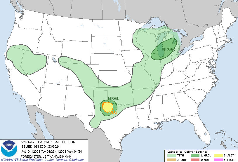
SPC Outlook
NWS Forecast
Weather History
1968: A tornado struck Big Rapids in Mecosta County, injuring 11 people and doing half a million dollars in damage as it covered a path 10 miles long.
1986: Freezing weather prevails across Lower Michigan. Record cold temperatures for the date include the 19 degrees at Muskegon and 20 degrees at Grand Rapids which is also a record for coldest so late in the season.
On April 23, 1985, the daytime temperature rose to 85 degrees in Flint, which is the record high temperature for the day. Curiously enough, the very next year, in 1986, the overnight temperature dropped to 22 degrees, setting the record low temperature for this day.
1948: A three block long section was devastated at the edge of Ionia, Iowa in Chickasaw County by an estimated F4 tornado. Six homes and a church were leveled, and nine other homes were severely damaged. Two deaths occurred in the collapse of the Huffman Implement Store. Overall, the tornado killed five people, injured 25, and caused $250,000 in damages. An F2 tornado touched down initially 5 miles northeast of Rochester. Barns, silos, windmills, and machinery were destroyed on four farms as this tornado tracked north.
1961: Severe weather struck the south suburbs of Chicago, IL. Joliet, IL reported an inch of hail with some hailstones the size of golf balls. Heavy rain from these storms also resulted in some flooding. A tornado struck the town of Peotone resulting in damage to nearly every building with damage also reported in Lorenzo and Wilton Center, IL. Estimated damage was $9 million with about 30,000 structures affected.
1989: Salina Kansas was the hot spot in the nation with a high of 105 degrees. The high of 105 degrees established an April record for the state of Kansas.
1999: On Friday, April 23, 1999, a horrific hailstorm moved southeast from Pennsylvania across Garrett County, Maryland and into the Eastern Panhandle of West Virginia. It had weakened some as it crossed Garrett County and the Allegany Front, but as it passed east of Keyser, West Virginia, hail began to increase in size once again. By the time it reached Capon Bridge in eastern Hampshire County, West Virginia, the size of the hail had grown from golf balls to baseballs. As it moved into Frederick County, VA, the hail storm continued to grow dropping golf ball size hail in a swath now reaching from the north of Winchester, south to Stephen City (about 10 miles). Hailstones grew to the size of Grapefruit (4 inches in diameter) east of Winchester. The storm continued east through Clarke County, southern Loudoun, and northern Fauquier doing considerable damage to Middleburg, then across Fairfax County hitting Centreville, Chantilly, Fairfax, Burke, Springfield, and Lorton with golf ball size to baseball size hail. It crossed the Potomac River and weakened slightly. It moved across northern Charles, clipped southern Prince Georges and then into Calvert County with 1 inch to 1.5-inch diameter hail and onto the Chesapeake Bay continuing southeast to the ocean. The damage left behind was incredible. In Northern Virginia alone, it amounted to over $50 million in losses to public and private properties. Some communities saw a third of the homes with siding and roof damage. Some required total replacement. Windows were broken, cars dented, and windshields smashed. Piles of shredded plant debris were left on the ground in the storm path. In about 6 hours of time, this one thunderstorm, moving at about 50 mph, did $75 million in damage. There have been other severe hail storms to hit this area before, but none to cause this much damage to property.
Forecast Discussion
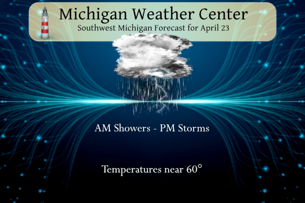
- Showers Early this Morning; Marginal Severe Risk Expanded

 Showers out ahead of the incoming short wave will continue to
spread over the region early this morning. The dry air at the
surface delayed the onset of precipitation, however scattered
showers continue to spread over the region and will continue
through the first half of the morning. Coinciding with this short
wave will be a strong low level jet. Winds upwards of 35 mph will
be possible through the early morning hours. The 925 mb winds
should become more amplified with more directional shear from the
850 and 700 mb layers. Looking at BUFKIT soundings CAMS have a
weak capping inversion from 2,500 to 4KFT this afternoon. If this
is breached, the steep low to mid level lapse rates of 7 to 9 C/KM
should greatly aid in convection.

 Couple those lapse rates, the strong shear from the LLJ and the
cold air aloft and there is a decent chance for severe hail.
Latest mesoscale analysis has decent DCAPE moving into the region.
Given that, SPC has expanded the marginal risk for severe storms
for across the region this afternoon. Timing wise, latest CAMS
brings the best opportunity for strongest convection will be late
in the day associated with the cold front, around 00Z. A
secondary LLJ is associated with that boundary as well, though it
is weaker then the one moving through this morning.

- Frost/Freeze Risk Wednesday Night/Thursday Morning

Clearing skies under surface high pressure and very dry air at the
lower levels will create favorable conditions for radiational
cooling Wednesday night into Thursday morning. Temperatures will
likely drop into the upper 20s across a wide swath of southern Lower
Michigan. The coldest temperatures will probably in the northeast
counties where mid 20s can`t be ruled out. The good news is that the
trend of a slightly warmer airmass at 850 mb continues with recent
model runs.

- Warmer and unsettled weather moves in for the weekend

As this final blast of cold air departs the area, a reorientation of
the longwave pattern will move into the central CONUS, setting
Michigan up initially on the "sunny" side of a building upper ridge,
but by Friday afternoon the ridge axis will have passed us and we`ll
fall into several days of deep southwesterly flow.

This pattern will allow much warmer and more humid air to stream
into our state, along with fairly plentiful cloudiness. At least 2
major disturbances/shortwaves will move through this southwest flow,
and bring rounds of rain and possibly storms beginning Friday night
and continuing all weekend. It`s unlikely the whole weekend will be
a washout, but the exact timing and placement of these shortwaves
are still pretty uncertain at this time, so some of the more
pertinent forecast details remain elusive. Instability and the risk
of possible severe weather will be monitored over the coming days,
as breaks of sunshine during the day followed by one of these
shortwaves coming through near peak heating could easily result in a
severe threat.
Idk why the sirens were sounding in Kent County but there was absolutely no reason for that. The tornado warning was for Allegan and Barry.
Tornado sirens in Kent County
Another tornado warning? That’s crazy.
Severe Thunderstorm Warning for me. Lots of lightning. Nice treat before I drive to Washington DC in the morning
We just had some thunder, one lightning stroke, and some slush..wasn’t in ball from but definitely like slush fall.. lol
Small hail and loud thunder here. Slightly gusty winds, sub severe
Quiet, little, weakening storm traveling overhead 😉
Everyone has their views on the climate. All points should be respected whether you agree or not. Respect has been lost when it comes to differences of opinions and none of it makes sense. We can all coexist and think differently. Only thing I will say is I don’t know why there is such a strong electric push when it’s clearly not ready. Why did we skip over making more hybrids? I had a hybrid years ago and loved it. Sadly I was in a big wreck when a reckless driver hit me in Grand Rapids and I totaled it… Read more »
Ha, I like bugs and bacon too
Bacon is good. Bugs would be way down the list 😂
While some automakers are really pushing EV, one major automaker is not. Toyota is all hybrid or ICE. We have one HEV (50 mpg) and one ICE vehicle. The ICE vehicle will be the next one to be replaced. I think I will go PHEV as a replacement. My neighbor has one and it’s sweet. It has 20K miles and he’s only filled it up a dozen or so times. I don’t worry about what others are doing because I know that I will not be able to influence them. We recycle and do what we can to help the… Read more »
I gotta say idk if I have heard of PHEV. Shows what I know. Sounds interesting. I agree clean air and water should be a priority and not political.
Plug in hybrid. It will run on battery power only for a time before the engine will kick in. It’s great if you do a lot of local driving. Like if you can get 50 miles on a charge and you drive less than 50 miles in a day, you don’t use any gas. Just plug it in at night.
I will never respect anyone that tells me global warming is good for our country! That just plain idiotic!
I will never respect anyone who claims to be a climate saint but engages in and supports corporate downhill skiing activities all winter that are HORRENDOUS for the environment and wildlife in the area! That is the height of hypocrisy!!!
Your ignorance is pathetic! Wow!
Even though the news stories that I have seen downplay it the Ruang’s eruptions may (or may not) have some effect on the weather leading into fall and next winter. Will have to keep a eye on how the sunrise and sunset pay out over the days ahead. The more red they are the more dust there could be in the upper atmosphere.
Slim
So I guess the biggest problem I have had with all these climate alarmists politicians is they are some of the biggest hypocrites on the face of the earth. Al Gore is a perfect example, jet setting all over the earth on private jets, having multiple massive homes. A lot of these politicians have homes on Martha’s Vineyard or on the Northeastern Atlantic coastlines, so they cannot actually be too worried about sea level rise if they are building these homes on the coast. Also, all of these climate policies they try to enact on a global scale seem to… Read more »
I would agree. A lot of the politicians are very hypocritical. Global warming is obviously real. But the response we should take is debatable. Like for example, we shouldn’t get all of our oil from the Middle East and Russia. And the Paris Climate Accord should not just be western countries- what about India and China which do most of the pollution. So I do think you have fair points
I agree with you Nathan!
Wow! The person who claims to be the biggest climate and earth guardian on the blog is actually contributing the most adversely to climate destruction all winter! Maybe he should practice what he preaches and not hurl insults at other members of the blog so often as he does!
https://www.treehugger.com/ski-resorts-and-the-environment-1203969
Funny thing is my wife and I are probably more carbon conscious than the climate alarmists claim to be. We have a 1000 sq ft house, that is heated by a high efficiency natural gas furnace. We do not have Central air because they are an electrical hog. Our gas bill generally runs at about $50 a month down to $30 in the summer time. Our electric bill is typically $40 a month. I drive a small car, that gets 40 mpg, on my 15 minute commute everyday back and forth to work. My wife lives within a mile and… Read more »
We also eat a mostly plant or chicken based diet as well! And we don’t take 8 hour gas guzzling round trips searching for snow every weekend in the winter.
That’s great! Climate change is very solid science, but I do 100% agree that the messaging makes it sound like each of us little guys are the problem. When in reality, it’s the large companies (especially in unregulated countries), that emit an enormous amount of carbon emissions. An example of this is the fact that some emissions laws in some states target older cars (which are already rare) and in the scheme of things make a very little impact. Rather the few large engines at electric plants emit 1000x more and are more easily regulated and upgraded to improve emissions.… Read more »
Yep, India and China are by far the largest producers of carbon dioxide and they don’t make any effort to change their ways.
Ignorant! Pathetic!
Forecast looks really pleasant coming up! The mild April rolls on.
If the forecast holds and we actually hit 24F on Wednesday night, that would result in a 90+% kill of fruit buds on trees. Yikes. Apples should be okay, but all the other fruit trees are in full bloom.
I checked my old photos and it looks like my trees are about 2 weeks ahead in bud/flower development compared to previous years.
The overnight low here in my MBY was 50 there was 0.03” of rainfall. At the current time it is cloudy and 55.
Slim
Yes, global warming and the big picture! Thank you for acknowledging some key FACTS! “Increasingly warming planet” yes that is a FACT! Greenhouse gases are a problem – yes that is a FACT! Plant based products are not only much better for the environment – they are better for your diet – FACT! Here is the problem – there are millions of ignorant citizens that either don’t acknowledge these facts and or could care less! FACT! They only care about themselves! How anyone could say global warming is good for the planet is either out of their mind or they… Read more »
The official H/KL yesterday at Grand Rapids was 64/34 there was no rainfall the sun was out 74% of the time. It was yet another windy day with the highest wind gust of 41 MPH out of the SW. For today the average H/L is 61/40 the record high of 84 was in 1915 and 1925. The record low of 20 was in 1986. The most rain fall of 1.44” was in 1999. The most snowfall was 0.7” in 2005. Last year the H/L was 46/34.
Slim
Thanks for the good information MV
Slim
Another informative post. There are many, many factors to consider. Some we cannot control, while some others we can.
Yesterday ended up as our 4th below normal temp day in a row! After today we revert right back to below normal temps again! WOW, what a cold stretch! Incredible!