We had a lightning strike near Otsego last night which sent our dog and cats scrambling for cover. It was quite loud so I don’t blame them. We had .20 of an inch of rain with a lot of thunder and lightning mainly from two cells that passed overhead and some rain on the backside. We had a tornado warning in northeastern Allegan County and northwestern Barry County which dropped a lot of hail there were over a dozen reports of hail up to 1″ in diameter. Cannonsburg and Saranac had 1″ hail.
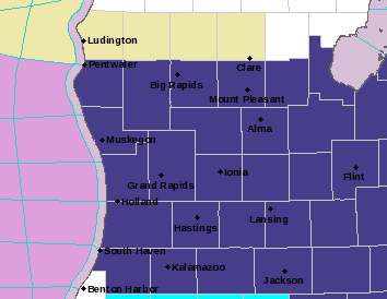
…FREEZE WARNING IN EFFECT FROM MIDNIGHT TONIGHT TO 8 AM EDT THURSDAY… * WHAT…Sub-freezing temperatures as low as 26 expected. * WHERE…Portions of central, south central, southwest, and west central Michigan. * WHEN…From midnight tonight to 8 AM EDT Thursday.
NWS Forecast
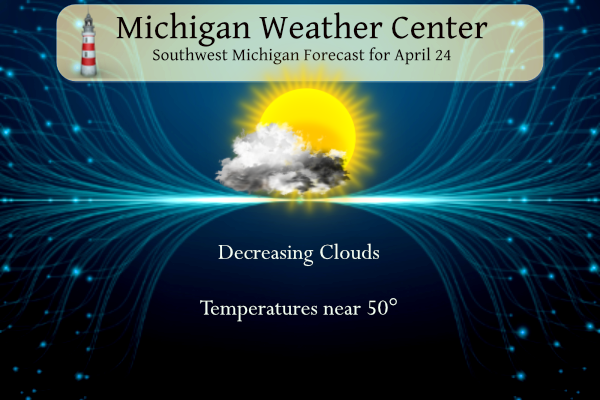
Clouds will be on the decrease today from north to south. By late afternoon all areas should be mostly sunny. Highs will top out in the middle 40s to lower 50s which is well below normal. Tonight, mostly clear to partly cloudy skies will result in temperatures dipping below freezing in most areas. Protect early-season tender vegetation tonight.
Weather History
1980: Only two days after setting record highs in the 80s, a record snowfall blankets Lower Michigan. Grand Rapids sets a record for the date with 2.4 inches of snow, after hitting 86 degrees on the 22nd.
On April 24, 2005, a 3-day snowstorm swept across Southeast Lower Michigan dropping 16.5 inches of snow on NE Clarkston. The thumb reported drifts of 3-4 feet of snow. The storm began on the 23rd and lasted through the 25th.
1880: Several tornadoes affected parts of central and southwest Illinois. One tornado of F4 intensity touched down near Jerseyville and killed one person along the 18-mile path. Another F4 tornado passed just north of Carlinville and lifted near Atwater, destroying 50 buildings. Six people died in Christian County by an F5 tornado, which tracked from 9 miles southwest of Taylorville to near Sharpsburg.
1908: Severe thunderstorms spawned eighteen tornadoes over across the Central Gulf Coast States claiming the lives of 310 persons. The state of Mississippi was hardest hit. A tornado near Hattiesburg, Mississippi killed 143 persons and caused more than half a million dollars damage. Four violent tornadoes accounted for 279 of the 310 deaths. The deadliest of the four tornadoes swelled to a width of 2.5 miles as it passed near Amite, Louisiana. The tornado also leveled most of Purvis Mississippi.
2003: The temperature soared to a maximum of 70 degrees in Juneau, Alaska. This is the earliest record of 70-degree reading to occur in Juneau.
2010: April Tornado Outbreak- During a significant severe weather outbreak across the South on April 22-25, 142 tornadoes raked the region, including 77 on April 24 alone. Ten died from the long-track tornado that swept across Mississippi on April 24. A long-lived twister left a trail of destruction extending over 149 miles from Louisiana through Mississippi, resulting in 10 deaths and 75 injuries. This EF4 storm, which grew to a width of 1.75 miles, sported the fourth-longest track in Mississippi history. This storm destroyed part of Yazoo City, Mississippi. The Swiss Reinsurance Company estimated insured damages with this outbreak at $1.58 billion. Click HERE for a video from Discovery.com
Forecast Discussion
- Widespread Freezing Temperatures Tonight into Thursday morning

Bottom line up front: In coordination with Detroit have decided to
upgrade the freeze watch to a freeze warning for Wednesday night
into Thursday morning.

Gusty Northwesterly flow continues with cloudy skies and strong
cold air advection behind the cold front. Downsloping flow will
continue today into tomorrow as dry, cold air settles over the
region as the day progresses. Dewpoints will drop today and
overnight into Thursday. Clearing skies follow from north to south
today as cold dry air mass pours in, with sunny skies emerging by
early afternoon as sfc dew pts drop into the teens north and 20s
south.

Guidance has been consistently showing high probabilities for sub
freezing temperatures early Thursday morning as sfc high settles
overhead with sfc dew pts of 15 to 20 in place. While some
questions of cloud cover remain, latest CAMS and ensemble guidance
have very few if any low to mid clouds with any high clouds
predominately in the far southwest. Winds are expected to drop
shortly after sunset so the calm winds will only aid in lowering
temperatures.

Latest NBM has dropped temps even colder. Coldest temps look to be
in the low 20s along the US 10 corridor with the mid to upper 20s
through most of the area. The warmest temps will be west of US 131
near the lakeshore. for these reasons have gone with a warning.

As the upper level ridge builds over the region expect clear and
dry conditions to continue through Thursday. Temperatures will
rebound with highs on Thursday in the upper 50s.

- Rounds of Precipitation in the Forecast Friday Night through Monday

An active spring time pattern is shaping up in the longer term of
this weekend into next week. A trough aloft will be replaced by deep
southwest flow as we head into the weekend...which means rounds of
precipitation. The first upper wave will swing through the region
Friday night into Saturday. At the surface a warm front will surge
through as well. Given a deep southwest flow plenty of moisture will
be available making both showers and thunderstorms likely. GFS and
ECMWF most unstable CAPE progs indicate values in excess of 1,000
j/kg. Rainfall amounts with this first event will likely be above a
half inch. Another rain event looks likely for Sunday into Monday as
we will be in the warm sector initially followed by a cold frontal
passage on Monday. Some shower activity may linger into Monday
night. We look mainly dry for Tuesday into Wednesday.

- Warmer Weather Expected This Weekend into Early Next Week

The deep southwest flow will bring much warmer air into the region.
850mb temperatures will largely be in the +10C to +14C range this
weekend into next week. Highs in the 60s and 70s are expected which
is well above normal highs which are around 60. In the warm sector
on Sunday its not out of the realm of possibilities to make a run at
80. The ECMWF MOS guidance actually has a high of 80 on Sunday at
GRR.
Let’s hope the freeze is not as bad as expected… unfortunately it looks like clouds clear out this evening and we get a lot of radiational cooling. At least the crops north of US-10 are probably not that far along… but much of our area away from the lake will get at least 3 hours below freezing. The forecast is 30 for GR, so not a “hard freeze”. Will be close though. Areas to the NE of GR will run cooler and probably get a hard freeze. After tonight we are likely in the clear, aside from some crazy May… Read more »
Update from the NWS: Hard freeze on track for tonight with most places dropping into
the 20s.
So it does look like most areas will get a hard freeze. Their point-and-click shows 30F… but perhaps that is running a bit warm
Farmers will be financially protected no matter what happens, but it would be nice not to lose our local fruit crops this year.
Gosh I hope it’s not bad..kiddo works for local fruit farm.
I just did what I could to protect some of our plants and rhubarb is coming up…
The Cold Weather Crazies better get out and enjoy their overnight freeze tonight, because after that, above normal temps for weeks on end! BRING IT!!! LETS ROCK!!!
https://weather.com/weather/tenday/l/52aab230ef88e4f2bb12857231a5dd58392e78a71b90e01d57a11d827658eb55
You mean it might finally warm up? Wow!!
I love early summers!
Funny it’s been warm for months but some are just in denial after our 3 week winter we had! LOL!!
Funny we are in a FREEZE warning and the warm weather fanatic are talking about summer! Too funny and totally delusional as usual!
Interesting to note that 4 out of the last 5 days we have seen below normal temps and now we are in a FREEZE warning and more below normal temps!!! Like I said last week – this week will feature a lot of below normal temps! Wow and another spot on prediction despite the constant warm weather hype!
Interesting that this “cold” month has only had 6 days with below average temps!! LOL!!
https://forecast.weather.gov/product.php?site=grr&product=cf6&issuedby=grr
38 in East Lansing right now is it February or April 😆… I am seeing 80’s though in May! I never really start enjoying everyday Michigan warmth till May gets here anyways as most should its Michigan…INDY
Yes wind chills in the low 30’s! Incredible cold!
All 60’s and 70’s in the long-range forecast. It’s finally that time where summer weather begins for good!
You mean summer temps haven’t been here since March! That is about the time you said summer is here! What a joke!
You said we’d have snowstorms til June! How’s that working out??
Four consecutive days in the 70s just last week.
Wrong again.
Looks like we will finish April between +3 to +5 degrees warmer than average. The warmth just won’t stop!
Lol! But it’s been a “cold” April! LOLOOLOLL!!!
Another great golf morning today! Wind chills in the 30’s! Incredible late April cold is coming!
There were a couple rounds of thunderstorms last night. They did not produce much rainfall as the official amount was 0.05” and here in MBY I only recorded 0.03”. I work for the Whitecaps and there was a lot more rain at the ballpark. The storms had a lot of lightning with them. It was the most lightning around game time in a long time. The Whitecaps did win the game 6 to 2. The overnight low here in MBY was 36 at the current time it is cloudy and 37.
Slim
The official H/L yesterday was 62/47 there was 0.05” of rainfall at the airport. It was yet another windy day with the average wind speed of 14.7 MPH and the highest gust of 36MPH out of the SW. For today the average H/L is 62/41 the record high of 86 was set in 1915 and the record low of 25 was set in 2015. The most rainfall of 1.46” fell in 1957 the most snowfall of 2.4” fell in 1980 the most snow of the ground is 1” in 2005 and 1980.
Slim
Tornado warning yesterday and a freeze warning today! The cold pattern continues! Wow!