We have had a lot of conversations on climate change as of late. Since the early to mid-1800s, with the industrial revolutions that were happening, predominantly in Europe and the United States, there began a severe increase in the release of carbon dioxide, methane, and nitrous oxide into the planet’s atmosphere. Human activities such as burning fossil fuels, including coal and oil, increased greenhouse gas concentrations in our atmosphere. I have read that burning coal was so bad in London the city was wrapped in a black fog so bad one couldn’t see two feet in front of them. We have similar circumstances in China today. We have had flip-flops in climate through the ages not caused by humans which you can see in the following articles.
About 14,500 years ago, Earth’s climate began to shift
from a cold glacial world to a warmer interglacial
state. Partway through this transition, temperatures
in the Northern Hemisphere suddenly returned to
near-glacial conditions. This near-glacial period is called
the Younger Dryas, named after a flower (Dryas
octopetala) that grows in cold conditions and that
became common in Europe during this time. The end of
the Younger Dryas, about 11,500 years ago, was par-
ticularly abrupt. In Greenland, temperatures rose 10°C
(18°F) in a decade (Alley 2000). Other proxy records,
including varved lake sediments in Europe, also display
these abrupt shifts (Brauer et al. 2008).
The Younger Dryas is clearly observable in paleoclimate
records from many parts of the world. In the Cariaco
Basin north of Venezuela, for example, temperatures
decreased about 3°C (5.5°F), although some of this
cooling might have been due to greater upwelling of
colder subsurface water (Lea et al. 2003). In many parts
of the Northern Hemisphere tropics, conditions also
became drier (Hughen et al. 2000; Wang et al. 2001).
The story in Antarctica is somewhat different, however.
The ice core record at Dome C (See figure on page 2)
shows that climate changes in Antarctica were out-of-
phase with those in the Northern Hemisphere (EPICA
This near-glacial period is called the Younger Dryas, named after
a flower (Dryas octopetala) that grows in cold conditions and that
became common in Europe during this time.
Community Members 2004). At Dome C, the amount
of the hydrogen isotope called deuterium, expressed
here as δD, is proportional to temperature. The deu-
terium record indicates that, contrary to the Northern
Hemisphere records, temperatures were relatively low
prior to the Younger Dryas (a period called the Antarctic
Cold Reversal) and rose during the Younger Dryas. This
pattern provides an important clue about what caused
the Younger Dryas, as will be discussed next.
The Younger Dryas occurred during
the transition from the last glacial
period into the present interglacial
(the Holocene). During this time,
the North American, or Laurentide,
ice sheet was rapidly melting and
adding freshwater to the ocean.
Scientists have hypothesized that,
just prior to the Younger Dryas,
meltwater fluxes were rerouted
from the Mississippi River to the
St. Lawrence River. Geochemical
evidence from ocean sediment
cores supports this idea (Carlson et
al. 2007), although other possible
routings such as to the Mackenzie
River cannot be ruled out presently.
A more northerly routing of melt-
water has a greater impact on the
salinity and density of the surface
ocean in the North Atlantic, which
can cause a slowing of the ocean’s
thermohaline circulation and
climate changes around the world.
Multiple proxies for the thermohaline circulation
indicate that such changes occurred during the
Younger Dryas (McManus et al. 2004; Praetorius et al.
2008; Lynch-Stieglitz et al. 2011). Eventually, as the
meltwater flux abated, the thermohaline circulation
strengthened again and the climate recovered.
The record from Dome C in Antarctica supports this
explanation. If the thermohaline circulation were to
slow, less heat would be transported from the South
Atlantic to the North Atlantic. This would cause the
South Atlantic to warm and the North Atlantic to cool.
This pattern sometimes called the “bipolar see-saw,”
is observable when comparing the GISP2 and Dome
C records for the Younger Dryas (EPICA Community
Members 2004).
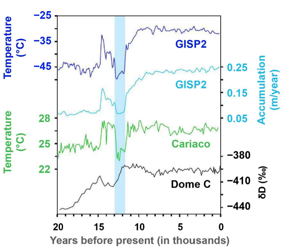
Climate changes associated with the Younger Dryas, highlighted here by the light blue
bar, include (from top to bottom): cooling and decreased snow accumulation in Green-
land, cooling in the tropical Cariaco Basin, and warming in Antarctica. Sources: Alley
(2000), Lea et al. (2003), EPICA Community Members (2004).
Some important datasets related to
the Younger Dryas:
• Alley (2000), temperature and accumulation from the
GISP2 ice core, Greenland
• Hughen et al. (2000), sediment grayscale from core
PL07-58PC, Cariaco Basin
• Lea et al. (2003), sea surface temperature in the Cariaco
Basin based on Mg/Ca of forams
• Wang et al. (2001), δ18O data from Hulu Cave in China
• McManus et al. (2004), sediment geochemistry of core
OCE326-GGC5, Bermuda Rise
• EPICA Community Members (2004), δD data from the
Dome C ice core, Antarctica
• Carlson et al. (2007), sediment geochemistry of the St.
Lawrence estuary
• Brauer et al. (2008), sediment geochemistry of Lake
Meerfelder Maar, Germany
• Praetorius et al. (2008), sediment grain size of core
ODP984 in the North Atlantic
• Lynch-Stieglitz et al. (2011), sediment geochemistry from
the Florida Straits.
More to come in future posts…
NWS Forecast
It will be mostly sunny and warmer today, though high clouds in the afternoon and gusty winds may make it feel a bit chilly at times. Highs will be in the 60s. Rain showers move in after midnight tonight and continue for Tuesday.
Weather History
1976: A tornado damaged several homes northeast of Burlington in Calhoun County.
On April 22, 1875, Detroit had a record low temperature of 20 degrees. The day before, on the 21st, Detroit had another record low of 21 degrees.
1883: A tornado outbreak from Louisiana to Kansas claimed the lives of at least 127 people and injured over 800 others. One of the tornadoes destroyed the town of Beauregard, Mississippi.
1978: Lightning sometimes strikes tents. In this case, a tent containing some sleeping Girl Scouts was hit by lightning as they were camping at DeGray Lake in Arkansas. Two of the Girl Scouts suffered minor burns.
1999: A one million dollar air charter Bowling 727 flew into large hail. Although the plane and its 66 occupants landed safely, the aircraft was declared a total loss.
2003: Tropical Storm Ana became the first Atlantic tropical storm since records began in 1871 to form during April. Maximum sustained winds reached 55 mph. Starting as a non-tropical area of low pressure on the 18th about 210 miles south-southwest of Bermuda, it was classified as a sub-tropical storm early on the 20th, it gained full tropical characteristics near 0000 UTC on the 21st, developing an “eye” feature.
Forecast Discussion
- Frost Advisory Ongoing, Elevated Fire Danger Today

Observations show most of West Michigan is in the mid to upper 30s
right now, and expectation is that temps fall into the low to mid
30s by daybreak south of US10, where the growing season has begun,
given clear skies and light winds. Thus the Frost Advisory looks to
be in good shape.

Warming temperatures are expected today as shortwave ridging
dominates the forecast with highs in the low to mid 60s. Given RH
values falling into the 25-30 percent range, and 15-20 mph winds
gusting to 25, a period of elevated fire danger may develop in the
afternoon.

- Showers Tonight into Tuesday

Rain showers then increase late this evening as the low level jet
ramps up across Lake Michigan and spread from northwest to
southeast. Those clear the area by daybreak Tuesday, giving a window
of lower precip chances except for the chance some showers may sneak
into the I94 corridor.

Convective showers then develop Tuesday afternoon as low-level lapse
rates near 9C/km paired with modest mid-level lapse rates result in
a few hundred joules of CAPE developing in low-topped convection.
This pairs with lift from a passing shortwave and cold frontal
boundary to provide scattered to numerous showers. Moisture will be
lower with dewpoints in the upper-30s to low 40s however so only a
slight chance of thunder exists. Showers continue into early
Wednesday morning.

- Another round of cold air mid-week

Starting Tuesday evening the cold front will be through Lower
Michigan and we will again by under the influence of cold Canadian
air. This brings us yet again into a risk window for frost/freeze
with tender vegetation - including many of the the vaunted West
Michigan fruit crops. We`ll basically have two nights of concern -
both Tuesday night and again Wednesday night. One point of good news
is that it is starting to look like clouds may not clear out in time
on Tuesday night to produce a widespread freeze (except in far
northern areas), so that means Wednesday Night will be the one we
need to watch the closest. All the basic ingredients for a classic
late spring freeze are expected to be in place - surface high
pressure resulting in light winds, a dry lower atmosphere, clear
skies to allow radiational cooling, and 850 mb temperatures in the -
3C to -6C range. A silver lining here is that the models have backed
off the magnitude of this cold airmass (as indicated by 850 mb
temperatures) by a degree or two since yesterday.

- Warm and potentially stormy next weekend

We flip the switch back into warm air advection mode starting
Thursday, and this time it looks like our overall longwave weather
pattern will be changing. In other words, this should bring an end
to the rollercoaster weather and usher in a more sustained warm and
spring-like airmass (for at least the foreseeable future). Deep-
layer southwest flow associated with a building upper ridge over the
heart of the country will surge 850 mb temperatures in Grand Rapids
from -5C Thursday morning to +12C on Friday afternoon. This weather
pattern will also surge humidity into our neck of the woods, with
dewpoints pushing 60F by Saturday and Precipitable Water approaching
1.25. Moisture and instability are 2 of the 3 ingredients necessary
for storms, and the 3rd is some type of forcing mechanism, which
could come in the form of a vigorous shortwave that moves through
the upper Great Lakes sometime on Saturday. *Caveat* There remains
uncertainty with the timing and positioning of this shortwave, and
these elusive details will probably make the difference between
garden-variety rain showers and storms that get more organized and
potentially strong. Stay tuned throughout the week as we refine
these forecast details.
For us in Michigan, global warming is turning us into a very nice year round climate! Warmer shorter winters, longer summers, and beautiful late falls.
That’s what I’ve been trying to point out! We are in a great spot here in Michigan when it comes to global warming!
Looks like a decent week temperature wise. Hope you all enjoy. I’m going to be off to Washington DC for a vacation. Spending time exploring the sites around the city. First time going so will be a nice time. On the drive back I’ll be visiting the Flight 93 memorial in Shanksville, PA. If anyone has any travel suggestions let me know (places to stop, restaurants etc).
Kyle,
Definitely go to the memorials at night!!! We went before covid for like 4 days. We used a private tour company. We sent them our list… the night tour was the neatest!!! Finding someone on the Wall from our area is always tough!
Enjoy have fun and learn lots… we learned we stayed in the hotel the attempted assassination of Reagan took place…there was a marker there…
With clear skies and light winds the overnight low here in MBY fell to 31 at the current time with clear skies it is 32.
Slim
The official H/L yesterday at Grand Rapids was 51/35 there was no rainfall. It was once again a rather windy day with the average wind speed of 11.1 MPH and a peak wind of 37 MPH out of the W. The sun was out 97% of the time. For today the average H/L is 61/40 the record high of 86 was set in 1980 the record low of 24 was set in 1950,1986 and 2020. The most rainfall of 1.72” was in 1999. The most snowfall of .01” was in 2015,2002 and 1984. Last year the H/L was 51/35.
Slim
Great write up Michael. It was a very good read.
Yes, That was a good write up.
Slim
Agreed.
Early on, I was not aware that London Fog (like the clothier) was not just plain old fog, but rather pollution. It is amazing to look at early photographs of London during that time. The prevalence of lung cancer must have been incredible.