We received two inches of snow yesterday which brings us to three inches thus far for November. Yesterday’s high was 34° and the low was 27°. The heavy snow has moved into the extreme SW corner of the state where there is a winter storm warning through tomorrow at 10 am where a foot or more snow may fall.
Our turn comes tomorrow from 10 am through late Friday where 10 to 12 inches of snow may fall between the I96 and I94 corridors. I am thinking the watch will change to a warning before tomorrow morning. Chances of more snow will continue through at least Sunday.
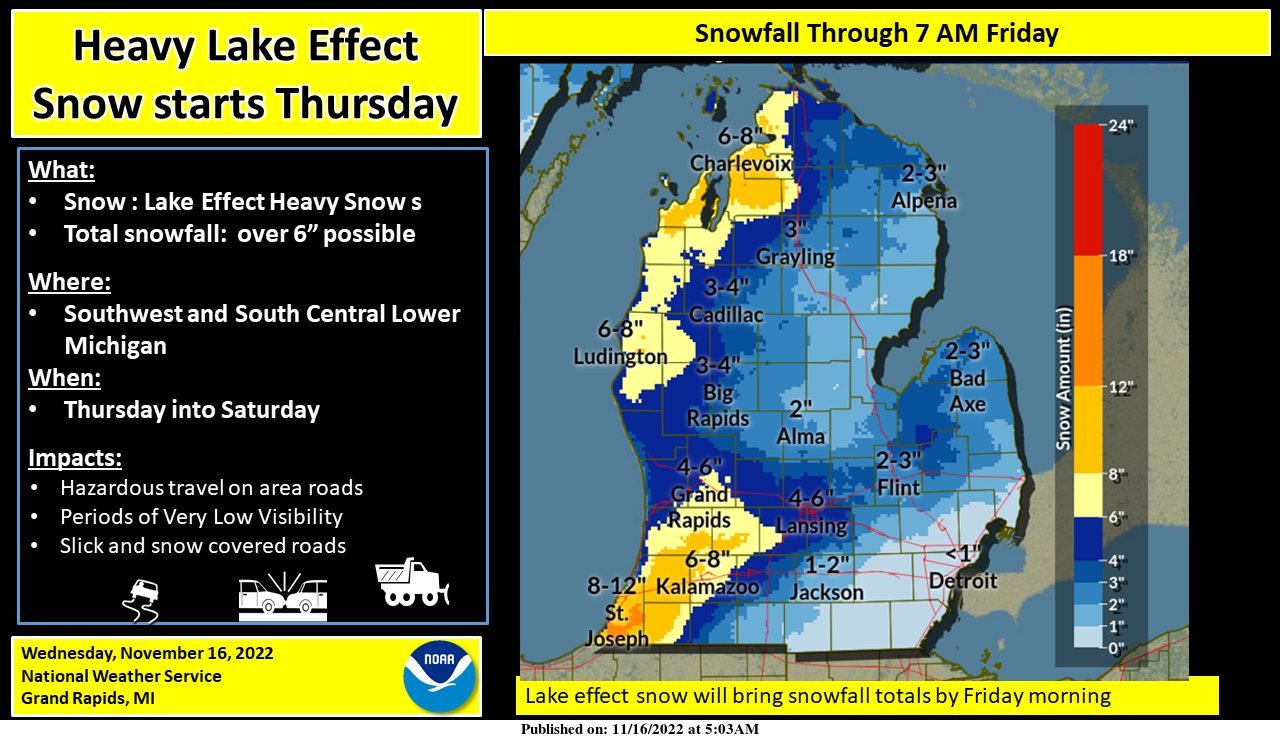
Even as our snow from yesterday’s snow event has come to an end, yet another snow event is on the way for us from Thursday into Saturday. It is the result of unusually cold air, for this time of year, moving over the Great Lakes. This time winds will be more westerly than northerly, so the lake snow bands will get well inland. The heaviest snow will be between I-94 and I-96. Another area of heavier snow is expected north of Muskegon and west of US-131 during this same time frame. Temperatures will be below freezing for much of this time, so roads will become snow-covered and slippery. By Saturday evening some locations could have well over a foot of snow on the ground.
Weather History for SW Michigan
November 13
1986: High temperatures are held in the upper teens to lower the 20s as arctic air pours into Lower Michigan. The high of 19 degrees at Grand Rapids is a record for the date and the coldest high temperature for so early in the season.
November 14
1908: Heavy snow falls across western Lower Michigan with a total of 16 inches at Muskegon, a record total for any November day.
November 15
1933: Michigan is in the grip of a four-day cold snap. The low of 10 degrees at Grand Rapids only rise to 18 degrees during the afternoon as lake effect snow showers swirl around and an icy northwest wind makes it feel even colder.
November 16
1959: A vast area of arctic high pressure brings record cold to much of the continental United States. High temperatures only reach the teens across much of Lower Michigan followed by record lows in the single digits on the morning of the 17th.
November 17
1989: Grand Rapids picks up seven inches of snow, bringing accumulations during a three-day storm to over a foot.
2013: A squall line of severe thunderstorms moved through Lower Michigan during the afternoon bringing widespread wind damage. Hundreds of trees were knocked down and thousands lost power from downbursts and brief tornadoes along the line of storms.
November 18
1958: Record high temperatures are set all across Lower Michigan as a southerly flow of air pushes afternoon high temperatures to around 70 degrees. At Muskegon, the temperature hits a record 71 degrees for the second day in a row.
2014: Arctic air prevails with high temperatures in the teens and heavy lake-effect snow. Nearly 10 inches of snowfall at Grand Rapids, contributing to a record November total of 31 inches.
November 19
1930: Record late-season warmth was across Lower Michigan with highs of 74 degrees at Grand Rapids and Lansing.
SE Michigan Weather History
November 13
On November 13, 1920, Wayne County (Northwest Detroit area) received 4-inch diameter hail around 7:20 pm which is one of the largest, if not the largest, ever recorded in Detroit.
November 14
On November 14, 1986, the mercury fell to a record low in Flint of 12 degrees for two days in a row (the 13th and 14th).
November 15
On November 15, 2018, a low-pressure system brought a rain and snow mix to far eastern Southeast Michigan while all snow occurred elsewhere. Snowfall totals of around 4.5 inches were observed in the Tri-Cities area while a general 1 to 3 inches fell elsewhere.
On November 15, 2005, a third powerful storm hit the area in just a week and a half during November 2005, leading to yet another round of strong winds. The cold front pushed through during the evening, leading to another period of strong winds, occurring through the early morning hours of November 16. Southwest winds were sustained at 25 to 35 mph, gusting to around 50 mph, with the exception of Huron County, where wind gusts were estimated near 60 mph. Trees were downed along the lakeshore from Caseville to Grindstone City. Heavy rains also occurred across the region, and the combination of winds and rain led to property damage estimated at 7.2 million dollars. One man was killed (indirect) and another injured (indirect) in a vehicle collision caused by a tree that had fallen into the road in Northern Oakland County due to the strong gusty winds.
On November 15, 2001, a mid-month storm brought winds of 40 and 50 mph and also brought the most rain in a day for the month with nearly 2.30″ in the Detroit area.
Also on November 15, 1997, low pressure tracked across Michigan bringing light snowfall across most of Southern Lower Michigan with accumulations of 1 to 4 inches. However, cold north and northeast winds off of the relatively warmer waters of Lake Huron enhanced the snowfall amounts in eastern Sanilac and northeast St. Clair Counties where accumulations were generally 4 to 8 inches. Port Sanilac received 8 inches of snowfall, but Sheriff Departments reported localized areas of eastern Sanilac county received up to 12 inches.
November 16
On November 16, 1989, a snowstorm hit Flint and Saginaw and it came to an end during the early part of November 17. Saginaw received 8.0 inches of snow while Flint recorded 7.7 inches.
On November 16, 1933, both Detroit and Saginaw had record lows on the 15th and 16th for Detroit and 14th-16th for Saginaw. In Detroit, the temperatures were 10 degrees on the 15th and 8 degrees on the 16th. In Saginaw, temperatures were 11 degrees on the 14th, 7 degrees on the 15th, and 5 degrees on the 16th.
Also on November 16, 1932, a snowstorm that started late in the day on November 15 dumped 9.0 inches of snow on Detroit. This is the heaviest snowstorm in the month of November for Detroit.
November 17
On November 17, 2013, a powerful low-pressure system strengthened and tracked northeast across the western Great Lakes. As the cold front swept through the area, winds gusted to 50 to 60 mph during the overnight hours with a peak gust of 70 mph observed at Ypsilanti. The winds produced widespread damage and caused hundreds of thousands of power outages across Southeast Michigan.
Also on November 17, 1963, Genesee county experienced golfball size hail with a severe thunderstorm passing through.
November 18
On November 18, 2016, unusual late-season Autumn warmth shattered record highs for the date across the region. Detroit reached 73 degrees (breaking the previous record of 69 from 1941) while Flint and Saginaw both reached 71. Their previous records were 69 (1941) and 68 (1975) respectively.
Also on November 18, 1959, there were two days of record lows in Flint with 9 degrees on the 17th and 11 degrees on the 18th.
November 19
On November 19, 1953, this started a two-day streak of record highs in Flint with a temperature of 70 degrees on the 19th and 68 degrees on the 20th.
Forecast Discussion
--Snow Bands becoming lighter Today--

The surface low continues to spin and move eastward. The steady
snowfall will continue to shift to the northeast with snow bands
forming on the western side of the exiting low. Strong, persistent
snow continues to stream through Berrien county. However just
north of that in Van Buren county they are in a lull. So much so
that the winds going calm have allow all available moisture to
settle allowing for fog/mist and low level stratus to develop.

 Elsewhere westerly to northwesterly flow will continue to
dominate and allow periods of light snow today. Low to mid level
will persist over the region so cloudy skies will continue. High
temperatures will remain in the mid to upper 30s.
 Given these temperatures and where SW Michigan is located in the
traversing low, travel impacts are not expected today.

--Increased Lake Effect snowfall Tonight into Thursday--

 The next forecast question is the potential for heavy snow
tonight into Thursday in the southwestern corner of Michigan. The
northwesterly flow on the back side of this low will stream moist
air along a trough which will bring low level Omega along the
lake sure this afternoon and evening. This will bring a period of
heavy snowfall/squalls to Van Buren county and western Allegan
tonight. A round of 2 to 4 inches will be possible Tonight into
Thursday morning.

--Lake enhanced Snow Thursday through Friday--

Have issued a watch for Thursday night through Friday due to the
potential for heavy snowfall.

Periods of heavy snowfall will plague the area Thursday through
Sunday. The tricky part is identifying where areas will be most
impactful. With a polar jet overtop, A low jet moving through and
north westerly flow across the lake there will be a good 12 to 18
hour period from Thursday into Friday for heavy snow bands in
between the I-96 and I-94 corridors. During that timeframe there
is a good congruence of low level moisture, cold air advection,
instability and upper level support which should create FGEN bands
for potentially 6 to 10 inches of snowfall Thursday night through
Friday.
 A second area of heavy snowfall through this time frame will be
further north along and to the south of the the US 10 corridor,
north of Newaygo and towards Manistee.There will be increased
instability and frontal genetic forcing daytime Thursday. This
area could see 4 to 8 inches of snowfall. Headlines for that
region may be needed.


--Periods of Heavy snowfall into Sunday--

 The synoptic pattern conducive for heavy snow will continue
through Saturday Several shortwaves will propagate through the
area which will invigorate snow band. The lakeshore could see
persistent snowfall through this timeframe with snow fall
infiltrating eastward as the short wave troughs pass through.

Travel impacts will be possible through the weekend due to
slippery roads and greatly reduced visibilities at times in
heavier snow showers/squalls. Heaviest totals over a several day
period will likely exceed one foot for some areas near and west of
131 and at times the heavier snow showers will extend eastward
through lower MI along the I-96/I-94 corridors as far as Hastings
particularly during the afternoon and evening hours.

The upper level trough looks to finally shift to the northeast on
Sunday which will bring divergent flow and slightly warmer air
which will end the copious snowfall.
The 18z RDB model gives GR 8 to 10 inches from this snow event! incredible!
Get prepared now! This winter will be rocking! This is just the warm up! By January we will be getting hammered with tons of snow!
https://www.weather.gov/grr/weatherstory
What a storm! Winter is the best! Bring it!
Record snowfall coming the next few days not out of the question….I hope everyone has a safe plan put in place if stranded somewhere we could have snow rates a ince a hour this time tomorrow many schools will be closed on Friday…INDY
With this set up we easily could be seeiing 15 to 20 inches of snow in southwestern Kent Ottawa and Allegan Countys this is definitely the big daddy lake effect snow storm coming…INDY
I agree, I think someone will see 20+ inches over the whole week (Monday-Sunday) easily if this pans out
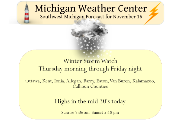
Winter Storm Warning for all the counties that were under the watch. Advisories elsewhere. 6-12” in the Warned area. 2-7” in the advisory
I’ll add it shows 8-14” for the lake shore counties in the warning. 6-12” for the rest of the warned counties
…WINTER STORM WARNING IN EFFECT FROM 7 PM THIS EVENING TO 7 AM
EST SATURDAY…
* WHAT…Heavy snow expected. Total snow accumulations of 8 to
14 inches.
* WHERE…Ottawa, Allegan and Van Buren counties.
* WHEN…From 7 PM this evening to 7 AM EST Saturday.
…WINTER STORM WARNING IN EFFECT FROM 7 AM THURSDAY TO 7 AM EST
SATURDAY…
* WHAT…Heavy snow expected. Total snow accumulations of 6 to 12
inches.
* WHERE…Kent, Ionia, Barry, Eaton, Kalamazoo and Calhoun
counties.
* WHEN…From 7 AM Thursday to 7 AM EST Saturday.
…WINTER WEATHER ADVISORY IN EFFECT FROM 7 AM THURSDAY TO 7 AM
EST SATURDAY…
* WHAT…Snow expected. Total snow accumulations of 2 to 7
inches.
* WHERE…Portions of central, south central and west central
Michigan.
* WHEN…From 7 AM Thursday to 7 AM EST Saturday.
I’m looking forward to the update… I’m thinking they will go with a warning in the WSW counties and an advisory in most of the surrounding counties, including Lansing. But we will see soon…
Rock n roll will never die and winter in West MI is the best!
34 here and quiet. Noontime local TV met thinks 2-4″ for this area between tomorrow and Friday – more possible towards the west, obviously.
Being the first winter weather event of the season, I suspect that WSWs and WWAs will be issued.
Woke up to the Winter Storm Watch alert on my phone. Looks like some hefty totals are coming potentially to parts of the area. Hard to believe it was 75 last week. Goes to show you how fast a pattern can flip.
Pattern change indeed! From a late summer pattern to a mid winter pattern! Incredible!
Temperature is down to 28 here with some frozen fog.
Slim
Their snowfall map is basically showing the first 24 hours (7AM Thurs- 7AM Fri) with around 4-8 in the WSW. I’d assume they will still go with a warning instead of an advisory even though it’s below the snow threshold
Just a dusting of snow here overnight. Temps remained above freezing.
Well, looks like I need to do the seasonal garage shuffle today – put the mower in the back and bring the snowblower to the front.
With an official snow fall of 3.2” Grand Rapids had its first snowfall of 1” or more for the 2022/23 winter season there was a total of 0.32” of precipitation with that snow fall. The official H/L was 33/28 and there was no sunshine. Here in MBY I have just over one inch of snow on the ground. With clear skies the temperature at the current time is 30 here at my house. For today the average H/L is 47/33 the record high of 68 was recorded way back in 1896 and the record low of 11 was set in… Read more »
>>>>>>BREAKING NEWS>>>>the RDB seasonal snowfall prediction just came in! Grand Rapids can expect around 90 inches of SNOW this season (+/- 5 inches). Get ready for somewhere between 85 to 95 inches of snow and if we can avoid some winter rain we may actually top 100 inches! Get ready to Rock!
Good call Indy! WSW in mid November! Wow just wow!
Thank you thank you …INDzy