Yesterday we had a high of 36.6° and the low was 29.5° with another high of snowfall in Otsego. We received another inch of snow late in the evening which brings our total to four inches.
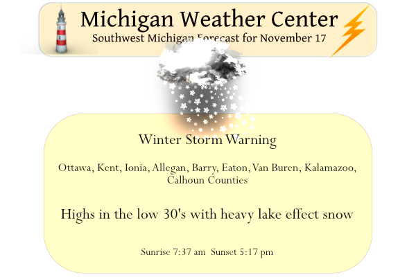
We will be receiving our first significant snowfall of the season today through at least Saturday morning. Over a foot of snow is forecast for the Otsego/Plainwell Area!
Latest Warnings & Advisories
...WINTER STORM WARNING REMAINS IN EFFECT UNTIL 7 AM EST
SATURDAY...

* WHAT...Heavy snow expected. Total snow accumulations of 8 to 14
  inches. Heaviest snow expected today and Saturday.

* WHERE...Ottawa, Allegan and Van Buren counties.

* WHEN...Until 7 AM EST Saturday.

* IMPACTS...Travel could be very difficult to impossible. The
  hazardous conditions could impact the morning or evening
  commute.
...WINTER STORM WARNING REMAINS IN EFFECT FROM 7 AM THIS MORNING
TO 7 AM EST SATURDAY...

* WHAT...Heavy snow expected. Total snow accumulations of 6 to 12
  inches. Heaviest snow expected from mid to late morning through
  this evening and again on Saturday.

* WHERE...Kent, Ionia, Barry, Eaton, Kalamazoo and Calhoun
  counties.

* WHEN...From 7 AM Thursday to 7 AM EST Saturday.

* IMPACTS...Travel could be very difficult. The hazardous
  conditions could impact the morning or evening commute.
...WINTER WEATHER ADVISORY REMAINS IN EFFECT FROM 7 AM THIS
MORNING TO 7 AM EST SATURDAY...

* WHAT...Snow expected. Total snow accumulations of 2 to 7
  inches.

* WHERE...Portions of central, south central and west central
  Michigan.

* WHEN...From 7 AM Thursday to 7 AM EST Saturday.

* IMPACTS...Travel could be very difficult. The hazardous
  conditions could impact the morning or evening commute.
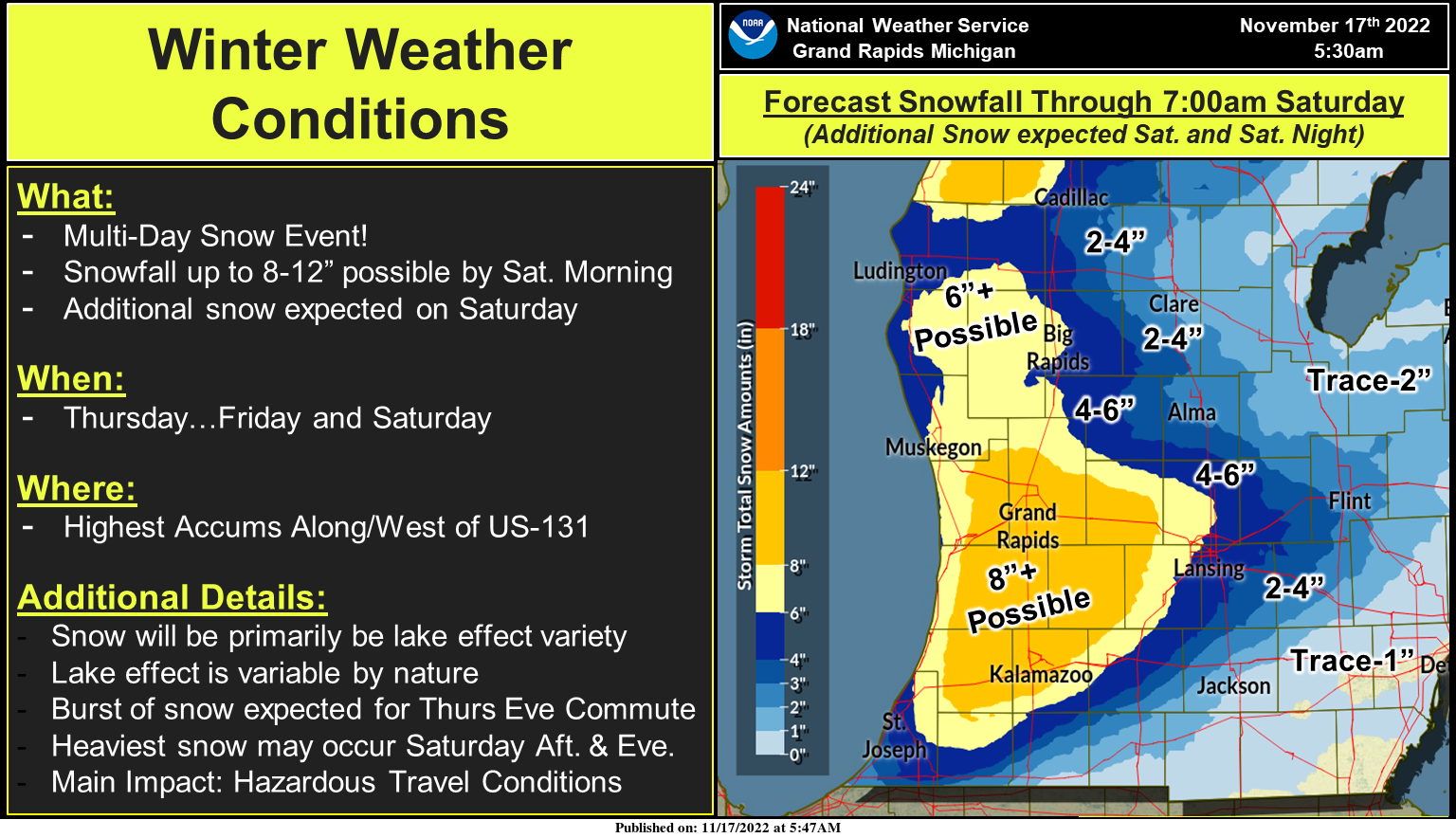
A multi-day heavy lake effect snow event begins in earnest today. The heaviest snow today is expected this afternoon and evening. The snow will continue into both Friday and Saturday as well. The heaviest snow of the entire event looks to occur Saturday afternoon and evening. Storm total snowfall by Sunday may exceed a foot in spots near and west of U.S. Highway 131. Given the variable nature of lake-effect snow (it occurs in bands), not everyone will see these totals. Be prepared for low visibilities, slippery travel, and variable conditions over short distances. Slow down if traveling and allow extra time to reach your destination.
Forecast Discussion
- Significant lake effect snow today through Saturday -

A consensus of latest higher resolution computer model guidance
continues to indicate lake effect snow showers will increase in
coverage and intensity later this morning through the afternoon
into tonight. This as already favorable h8 temps of around -9 C
early this morning fall to -12 C by 12Z Fri yielding even more
favorable delta t/s. Lake effect snow bands west of US-131 early
this morning will drift further inland by mid morning as low level
wind fields continue to slowly back from the nw to west.

00Z guidance consensus time height rh progs show favorable
upstream rh. The shortwave moving in from the nw this afternoon
will bring strong pva and lift and strong upper divergence. A
boost to inversion heights to around 8 kft is also apparent in
model fcst soundings for this aftn.

These aforementioned favorable ingredients will all combine to
bring significant les later today particularly in our favored
west to wsw flow snow belt regions. Westerly flow lake effect snow
showers will continue Friday as h8 temps continue to fall to
around -15 C by 12Z Sat. However we do not expect quite as much
snow accumulation tomorrow due to weaker omegas in the dgz and
weak pva/less favorable mid to upper level forcing.

The most prolific lake effect snow is anticipated Saturday as a
very strong shortwave moves in from the nw resulting in vigorous
omegas through the dgz. Inversion heights will become very
favorable as well reaching around 10 kft. Abundant 850-700 mb
upstream rh is noted as well. Colder temps by Saturday will also
result in more favorable snow ratios.

The bottom line to all this is we expect significant les today
through Saturday with potential for a foot or more of snow for
areas in the winter storm warning. Significant impacts to travel
are likely to develop across our area today through Saturday and
particularly in areas near to west of US-131.

- Tranquil weather returns late weekend into early next week -

The upper trough axis finally moves east Sunday and will be
followed by a moderating trend of h8 temps which will finally
bring an end to the lake effect snow. Fair wx with (relatively)
milder temps will return early next week.
Just took a snow fall measurement and here in MBY there is now 5.5″ of snow on the ground. I am sure much more has fallen. But with the warm ground it has really compacted and is more like synoptic snow then lake effect. It is very wet and as I said 5.5″ on the ground and just over 2″ on the road. And it has been reported that Grand Rapids public schools are closed for tomorrow. The record snow fall for today is 7.1″ set in 1989. For tomorrow the record is 9.6″ in 2014.
Slim
The band moving through currently is really intense. It seems 1-2 inch per hour rates… but it only lasts around 20-40 minutes per location it seems
Let it snow let it snow let it snow…INDY
Forget the Blake Harms school closing predictions! The RDB model shows virtually all the the GGR schools will be closed tomorrow! This could end up as one of the biggest snow events in GR history! Incredible!
What a storm! This could be a record breaker! Let it snow, let it snow, let it snow!
Thundersnow looks to have occurred in Barry County. Just saw a post from Bill.
Looks like it occurred in the area between Wayland and Middleville. A few lightning strobes on radar
Just picked up a quick inch. This band moving through is extremely heavy
Yup it was very intense here too. Probably the heaviest so far
Started snowing heavy here. Roads are snow covered. Winds are picking up.
M66 in Ionia is solid black ice
Here is the updated CPC outlook for December 2022
https://www.cpc.ncep.noaa.gov/products/predictions/long_range/lead14/index.php
And for the rest of the winter season
https://www.cpc.ncep.noaa.gov/products/predictions/long_range/seasonal.php?lead=2
There does not seem to be too change from the October update.
Slim
Snow so far for Otsego in MBY 5.5 inches – temp has fallen to 27.7 – moderate snow is falling. I had the tractor and snowblade out for the first time.
Just little over 4″ here in MBY the snow is now starting to stick on the road with the temperature now at 30.
Slim
OK, here is the updated CPC outlooks for December and then JFM. There does not look to be much change from the earlier out looks. So here is December 2022
https://www.cpc.ncep.noaa.gov/products/predictions/long_range/lead14/index.php
And here is JFM 2023
https://www.cpc.ncep.noaa.gov/products/predictions/long_range/seasonal.php?lead=2
Spring 2023
https://www.cpc.ncep.noaa.gov/products/predictions/long_range/seasonal.php?lead=4
Summer 2023
https://www.cpc.ncep.noaa.gov/products/predictions/long_range/seasonal.php?lead=7
and Fall 2023
https://www.cpc.ncep.noaa.gov/products/predictions/long_range/seasonal.php?lead=10
and just for the fun of it winter 2023/24
https://www.cpc.ncep.noaa.gov/products/predictions/long_range/seasonal.php?lead=13
Slim
Really nice squall line moving through right now with low visibilities. The wind really picked up
Here is the updated CPC outlook for December
https://www.cpc.ncep.noaa.gov/products/predictions/30day/
Will toss up the seasonal update when it is posted.
The snow has just picked up here again and is falling at a moderate rate.
Slim
Local TV just increased us here to 4-7” by Sat pm.
The ground was covered from this morning’s snowfall, but it’s all melted now. My snowblower is all gassed up and ready to go. Bring it!
There is now around 4″ of snow on the ground here in my yard. There is no snow on the road and only spotty snow on the sidewalks and driveways.
Slim
Currently white out conditions in my hood temperature 29* be safe outside…INDY
Yes, drive slow and don’t tailgate!
Looks like the winds may be shifting from more of a WSW flow to more due west currently
Great, that is better for GR and Northern Kent County! Keep the pounding of snow coming all day, all night and right into the weekend! Snowshoeing here I come!
9 years ago today at this time we were under a “Particularly Dangerous Situation” Tornado Watch. The first tornado warning was issued by NWS GR at 2pm for Muskegon and Newaygo County. Luckily we missed out on the worst of the tornadoes though. This is a day I won’t forget. Very rare for November. THE NWS STORM PREDICTION CENTER HAS ISSUED A * TORNADO WATCH FOR PORTIONS OF INDIANA FAR NORTHERN KENTUCKY LOWER MICHIGAN WESTERN OHIO LAKE HURON LAKE MICHIGAN * EFFECTIVE THIS SUNDAY MORNING AND EVENING FROM 1120 AM UNTIL 800 PM EST. …THIS IS A PARTICULARLY DANGEROUS SITUATION…… Read more »
NWS GR:
FORECAST CONCERNS DEAL WITH THE DAMAGING WIND THREAT SUNDAY VIA
SEVERE STORMS. THE MODELS HAVE BEEN PRETTY CONSISTENT FOR A COUPLE
OF DAYS NAILING DOWN THE TIMING OF THE PASSAGE OF A STRONG COLD
FRONT DURING THE AFTERNOON ALONG WITH UPPER LEVEL SUPPORT. AS SUCH
CONFIDENCE IS INCREASING WITH THIS FORECAST.
EVERY ONCE IN A WHILE EVERYTHING SEEMS TO LINE UP FOR A SIGNIFICANT
WEATHER EVENT AND IT/S BEGINNING TO LOOK LIKE SUNDAY IS THAT TIME.
Here is more on that date.
https://www.clickondetroit.com/features/2020/11/17/today-in-michigan-weather-history-tornado-outbreak-of-nov-17-2013/#:~:text=On%20Nov.,up%20early%20that%20Sunday%20afternoon.
Slim
It has been snowing at a light to moderate rate now since 8 AM. Here in my yard I have just under 3″ of new snow on the ground. There is just slush on the driveway and sidewalk. The warm ground and a air temperature of 34 is keeping total on the ground down.
Slim
November is trending above average snowfall and below normal temperatures it must be Winter time …INDY
How is that possible? Who knew?
The November snowstorm is right on track! Bring it! Rock n roll will never die!
Also the sun is approaching its lowest/weakest levels now. We only lose 40 more minutes of light at this point. So I’m sure the snow will be slow to melt next week
I can see the snow remaining on the west side of the state. If we only get a couple of inches here, the 40s predicted for next week may make all disappear.
Pretty heavy snow band moving though right now. I wonder if we will be able to rival any of the other November snowfall events… 2014 will be pretty hard to beat :O
Yesterday’s official H/L at Grand Rapids was 34/29 there was 0.03” of precipitation, 0.4” of snow fall. There was no sunshine at 7 AM there was 3’ of snow on the ground. The overnight low here in MBY was 24 when there was some clearing. At the current times it is 29 with light snow falling and there is around 1” of snow on the ground here. For today the average H/L is 47/32 the record high of 70 was recorded in 1953 and 1958 the record low of 9 was recorded in 1959. The record snow fall for today… Read more »
The sun was shining at 7:45 at my house. 5 minutes later it was heavy snow. Coming down very hard currently
The snowfall has also picked up a good bit here as well.
Slim
Here are some of the bigger November snow events at Grand Rapids with a warm Lake and a west wind. November 15/20 2014 27.8″. November 3/7 1951 23.4″ November 2/5 1991 17.2″ November 18/21 2000 17.1″. Of course it is way too early to tell if this year will play out to anything near what happened in those years but they are the bench mark for November snow events.
Slim
You think this is bad, check out Buffalo NYs forecast: Tonight Snow. The snow could be heavy at times. Some thunder is also possible. Low around 29. Southwest wind 9 to 17 mph. Chance of precipitation is 100%. New snow accumulation of 12 to 18 inches possible. Friday Snow. The snow could be heavy at times. Some thunder is also possible. Areas of blowing snow after 10am. High near 35. Breezy, with a southwest wind 13 to 20 mph, with gusts as high as 31 mph. Chance of precipitation is 100%. New snow accumulation of 11 to 17 inches possible.… Read more »
Wow. I took a video of the lighting over snow years ago. It makes everything look purple.
We did that yesterday adding up the next few days of snow.
We were getting prepped yesterday. Cleaning up the yard, hanging a few more Xmas lights!!
Hope hunters are being successful!!!
More from the Buffalo NWS:
Heavy lake effect snow expected. Total snow accumulations
of 2 to 4 feet in the most persistent lake snows. The heaviest
snow is expected late this evening through Friday night when
snowfall rates could exceed 3 inches per hour. Winds gusting as
high as 35 mph with produce patchy blowing snow.
I had a friend from the Niagara Falls/Buffalo area and I was able to experience a LES event like that while visiting her. It was spectacular.
It is interesting that the Forecast Discussion now mentions significant snow on Saturday.
I have lived here in west Michigan since 1984 and in that time one of the events that I have not see much was a good thundersnow storm. We did have some lightening with a October event in 1997. But that was just about it. I know there have been some who reported thundersnow but not a real thundersnow, snowstorm. The last one I that I seen was in March of 1984 just before we moved to Grand Rapids. Other big time thunderstorms events were in the big storms of 1967 and 1978 and a big storm in 1973. But… Read more »