Yes, winter has arrived! We have some light snow moving through the area early this morning which is just a slight taste of what may be coming tomorrow. We have 3.2 inches of snow for January thus far and 12.7 inches since November 1st (in Otsego).
We will see a brief period of snow this morning before we turn to the next storm. Keep in mind the storm is just now forming in the Rockies as we wait for it to establish itself and move to the east. That storm may dump 8+ inches tomorrow through Saturday, then the lake effect machine will kick in with the really cold air being drawn down from Canada. Needless to say, the area ski resorts will be rejoicing. Let’s try to keep the hype down.
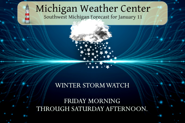
...WINTER STORM WATCH REMAINS IN EFFECT FROM FRIDAY MORNING
THROUGH SATURDAY AFTERNOON...

* WHAT...Heavy snow in excess of 8 inches possible. Winds could
  gust as high as 45 mph.

* WHERE...Portions of central, south central, southwest and west
  central Michigan.

* WHEN...From Friday morning through Saturday afternoon.

* IMPACTS...Travel could be very difficult to impossible.
  Widespread blowing snow could significantly reduce visibility.
  The hazardous conditions could impact the evening commute.
  Gusty winds could bring down tree branches.

* ADDITIONAL DETAILS...Bitter cold Arctic air and additional heavy
  lake effect snow will follow this system. Hazardous winter
  weather will likely continue through the remainder of the
  weekend into early next week.
Forecast
Weather History
1890: Temperatures reach a record high of 63 degrees at Lansing during one of the warmest Januarys on record.
1979: Arctic air and a deep snow cover combine to drop the temperature to a record low of 21 below zero at Grand Rapids.
On January 11, 2005, the city of Maybee in Monroe County received 7.2 inches of snowfall from a passing snowstorm.
U.S.A and Global Events for January 11th:
1898: An estimated F4 tornado struck the city of Fort Smith, Arkansas, just before midnight. The tornado, which touched down about 100 miles southwest of town, killed 55 people and injured 113 others along its track. Click HERE for more information from the Monthly Weather Review.
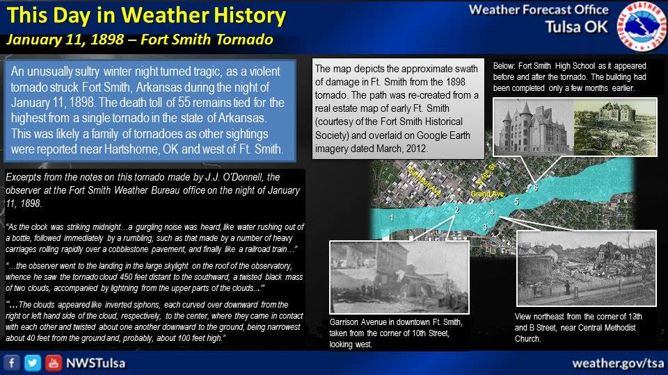
The image above is from the NWS Office in Tulsa, Oklahoma.
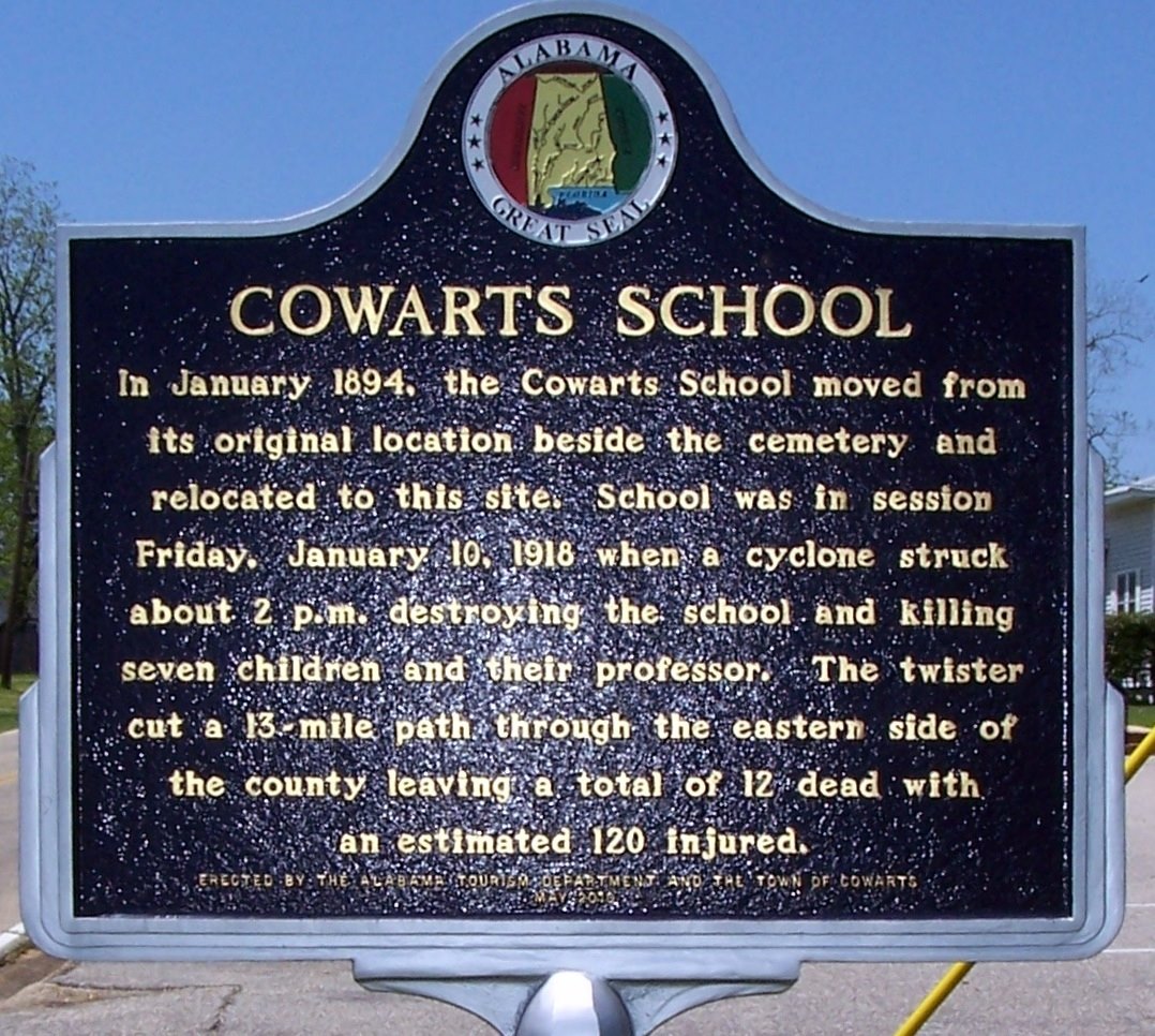
1918: A powerful area of low pressure brought snow and bitterly cold temperatures to Chattanooga, Little Rock, and Shreveport. Birmingham, Alabama, picked up an inch of snow. In far southeastern Alabama, an estimated F3 tornado virtually damaged every building in the town of Webb. The tornado leveled one rural school, killing one teacher and seven students. Please note, the date on the historical marker is an error. January 10th in 1918 was a Thursday.
1963: An F2 tornado was reported in Scott County, Indiana, north of Louisville, Kentucky. It was on the ground for 5 miles north of Scottsburg and damaged or destroyed several homes and barns.
1972: Downslope winds hit the eastern slopes of the Rockies in northern Colorado and southeastern Wyoming. Boulder CO reported wind gusts to 143 mph and twenty-five million dollars in property damage.
2010: Bitter cold temperatures gripped central and southern Florida with lows in the teens and 30s.

Forecast Discussion
The primary concern in the next 24 hours is light snow expected to
persist through midday. A mid-level shortwave and associated surface
low tracking across lower Michigan this morning will bring 1-2
inches of snow (isolated 3 inch totals) across West Michigan.
Snowfall is expected to peak just before the morning commute, with
both surface and road temperatures below freezing. Slick roads and a
few delays are possible for the morning commute.

Snow winds down mid-day Thursday with temperatures warming into the
mid 30s, improving road conditions by Thursday evening. Shortwave
ridging keeps conditions dry for most of Thursday night, however
snow from our next storm system may arrive as soon as 5 AM Friday.

- Heavy Snow and Strong Winds Friday Into Saturday

Snow is expected to move into the area from west to east Friday
morning into the afternoon and continue through Saturday. Whiteout
conditions along with blowing and drifting snow is possible with
gusts to 45 mph. Depending on the low track a brief period of rain
and lower snow to liquid ratios is possible along the southern two
tiers of counties Friday evening which could lower snowfall
amounts. Otherwise a swath of 8+ inches looks likely across a
majority of the forecast area. Heavy snow and winds are expected
to cause hazardous travel conditions, especially for the evening
commute, and could cause power outages ahead of a cold snap that
will move in for Sunday and continue into next week.

The system responsible for this period of hazardous weather is
currently over the Rockies and will strengthen as it moves into
the Plains and then into the Great Lakes. The trough will become
negatively tilted and quickly amplify as it moves into the area.
Positive vorticity advection, warm air advection, and the 850mb
low level jet move in Friday morning. There is initially some dry
air to work with so focused timing more toward the later part of
the morning and into the afternoon for start times. Snowfall rates
pick up to around an inch per hour for the evening commute with
the better frontogenesis with the approaching low. Depending on
the low track there could be a period of rain for Allegan to
Ingham counties and south which would bring a brief break in
accumulations and visibility reductions. Cold air quickly fills
back in behind the low will all snow expected for the whole area
late Friday night through Saturday.

Winds will be driven by the strong pressure gradient with a low
level jet around 50 knots overhead and 925 mb winds around 30 to
40 knots. Currently have wind gusts forecasted around 35 to 40 mph
picking up between 9am to 1pm as the snow moves in with gusts up
to 45 mph thereafter. As the low moves through Friday evening
areas under it will see a lull in wind gusts before the pick up
later Friday night into Saturday. Winds gusts then look to remain
around 30 to 35 mph along and south of I-96 Saturday night with
gusts more 20 to 25 north.

As for snowfall, the bulk of it looks to fall Friday afternoon and
Friday night with an axis of 8+ inches across the area. Snowfall
rates then decrease for Saturday, but the lingering strong winds,
and existing snowpack, and additional snowfall will continue
hazardous conditions.

- Lake Effect Snow and Arctic Air Sunday Into Next Week

Behind Saturday`s system a shot of Arctic air moves into the area
with highs mainly in the teens and lows in the single digits.
Winds chills during this time will hover above or below freezing.
These colder temperatures will combine with the warm waters of
Lake Michigan (currently around 40-45 degrees). With westerly
winds lake effect snow will be present throughout the rest of the
forecast period. Expect accumulating snow, especially along the
lakeshore, to continue travel impacts. If you were previously
wondering if winter would ever come, it has arrived.
Get ready to rock people! This storm means business and you were warned! Here is my post from 48 hrs ago! My point forecast is up to 14 inches of snow! WOW!
“WEATHER ALERT>>>>>>>>>Get ready to rock! For those out there that are still slow walking the Friday storm you need to wake up! A major snowstorm will be hitting West MI on Friday/Saturday! Take it serious and start preparing now! The major hazards are; heavy snow. low visibility, strong winds, possible power outages and very bad travel conditions! Don’t say that we’re not warned!!”
Looking more and more like we may finally get the “big daddy” we’ve been looking for, Rocky! Incredible!
Bring it on!
My current point forecast is 11 inches through Saturday evening! Wow, what a storm!
Get ready to rock! Let it snow, let it snow, let it snow!
https://www.weather.gov/grr/weatherstory
My point forecast got knocked down quite a bit, 3 inches for tomorrow during the day, 3 inches tomorrow night and 2 inches Saturday. Right in line with my 8 inch total prediction.
The two local stations’ snowfall projections are unchanged from last night. One station says 4-8” and the other says 6-10”.
Storm team 8 showed 6-10 for the Lansing area.
Here is the latest on the expected storm track! It looks good as it has moved a little to the East!
Blizzard warnings encompassing a lot of the state of Iowa. An upgrade for them from Winter Storm Warning.
Welcome to winter! We will be making up for lost time as far as the snow goes! A lot of lake effect and lake enhanced snow will be hammering us over the next 2 weeks! Check out all of the pretty colors on this map! Incredible snowfall potential!
https://www.instantweathermaps.com/GFS-php/conussfc.php?run=2024011112&time=PER&var=ASNOWI&hour=384
About a month ago I said I wouldn’t be surprised if a big storm came and dumped a ton of snow because it’s been so quiet for snow! If it pans out looks like my instincts were spot on! Incredible!
Yes and my prediction based on data and the teleconnector trends for a pattern change by mid January was spot on in a big way! Fortunately we were both 100% correct!
Anyone else see the NWS mention the potential for thundersnow? Incredible!
Was that in their afternoon discussion?
“The thing to watch later in the day Friday and Friday evening will
be the evolving/intensifying trowal feature which could contain 1-2″
per snow rates and possibly even some thunder.”
Wow!
Schools are closing fast and furious!! WOW, just wow, WOW!!!
WINTER WEATHER ALERT>>>>>> If the low pressure track stays over by the Lansing area or just east of Lansing, GR may absolutely get hammered! Get prepared now! Forget about the dry, warm El Niño! This could be the BIG DADDY! I herby dedicate this storm to the warm weather fanatics! This one is for you! Enjoy!
I will take a winter every year that doesn’t start til mid January!
…WINTER STORM WARNING IN EFFECT FROM 10 AM FRIDAY TO 7 PM EST SATURDAY… * WHAT…Heavy snow and high winds expected. Total snow accumulations of 8 to 14 inches. Winds gusting as high as 50 mph. * WHERE…Portions of central, south central, southwest and west central Michigan. * WHEN…From 10 AM Friday to 7 PM EST Saturday. * IMPACTS…Travel could become very difficult and perhaps impossible by Friday night. Blowing snow may significantly reduce visibility. The hazardous conditions will impact the Friday evening commute. Gusty winds could bring down tree branches and cause power outages. * ADDITIONAL DETAILS…Near blizzard conditions… Read more »
Winter storm warning! School is already canceled here too
Looks to be about 6″ here. Much more over there and up north.
NWS has Grand Rapids in a “major” severity index, Lansing “moderate”
Latest 18Z HRRR is further east than the 12Z run. At 12Z it had the low near GR now it has it near Lansing. Its coming more in line with the GFS and Euro.
Good stuff. Thanks Kyle.
I’m the type of guy that enjoys shoveling. However the snowblower IS on standby.
I’m with Slim. Still unsure how it will play out. In the meantime it doesn’t hurt to be prepared.
For what it’s worth, both Storm Team 8 and Fox are saying minimal mixing in the viewing area with a mostly all snow scenario. Kevin (Fox) just got off a webinar with the NWS and they seem to be thinking the same. If you want to see the maps he released head over to his FB page. I do not see them uploaded yet to the NWS site yet to post here.
Well I have snow shovels handy. The snowblower has gas. Now how will the storm play out? Well we shall see. My take right now is still not sure.
Slim
Rock on slim and trust me you will be very happy that you have your snowblower gased up and ready to rock!
The 12z ECMEW takes a deepening low just to the east of Grand Rapids and then it central lower Michigan. The lowest pressure reaches 972 just east of Houghton Lake. Then starts filling in over Lake Huron. The GFS are ERO are very close to each other. So will see how they look later today and more so tomorrow morning.
Slim
Latest GFS Ensemble takes the low pressure from Lafayette, IN northeast to Marshall, MI then over Lansing.
At least that is SE of GR but I would like to see it closer Ann Arbor/Det area!
Well that would still keep Grand Rapids all snow. As long as it tracks to the SE, you will be on the cold side of the system
That is the theory, but because it so close to GR if it actually tracked even more to the West that will mean less snow!
Yep. The more west less snow, more chances of rain and less wind until it passes. But there would be a better chance of a more west wind after it passes.
Slim
The latest on the low placement are very close to GR. Not sure how that will play out. But there could be some warm air and a possibility of rain or a rain snow mix. One thing I will bring up as to winds the winds near the low center will be less around it as it passes. We shall see. I will not make a total snowfall guess. It could be if the conditions are right that there is more Lake Effect than snow from the system.
Slim
We will see far more system snow than lake effect snow from this event!
I have you marked down for that. But we will see. I still think the low will be too close to GR for us and the models almost take the low across the middle of Michigan.
Slim
I will agree we are in a good set up for lake effect snow! It could be a scenario where we get 12 inches from the system snow and then 8 to 10 inches of lake effect?
Keep in mind the Tuesday storm moved father SE than expected. Maybe that will be the trend for this… we shall find out
The 12z HRRR has moved a bit east. Now it shows a bunch of rain for the Chicagoland area and Lansing is right on the line for not much snow and a bunch of snow.
My guess 8 inches at GRR Airport for Friday/Saturday total.
NWS GR is collaborating with nearby offices and will make decisions at the afternoon update.
The GFS hrrr model continues to look really promising. Snow starts after 7AM, picks up after noon (may have dry air initially). Pressure drops to 971mb passing over the area in the evening. Most of the mix stays SE of Grand Rapids. That’s just one model, but I’m liking how it looks 😀
A guy posted a video an hour ago of the 06z HRRR and it shows the low going right over South Haven and GR.
The latest GFS shows a slight east jog. Not by much but just slightly.
I am happy the low did not move more to the West, however I would like it to be a little more to East by the time it barrels into MI! Bring it on!
INDY’S thoughts on the storm Blizzard warnings 4pm today!! Get to the store grab more we have a BIG DADDY COMING!! Record snowfall Record cold!! INDY
My guess they will go winter storm warning with the comment blizzard conditions possible! Then on Friday take a closer look and consider blizzard warnings!
I think that is a likely scenario.
I also agree that they won’t go Blizzard Warning this afternoon. I’d agree with the Winter Storm Warning with a possible upgrade later if it looks possible. But ultimately that’s up to the weather office.
Let’s review the facts
1. A potential big storm is bearing down on us! Exact track details will become more clear later today!
2. Looks like we are entering into a snowy and COLD pattern
3.We are going to have an extended period that is phenomenal for winter sports (Skiing, Snowboarding, Snowshoeing etc) so bundle up get out of the house and enjoy winter!
4. The Michigan Weather Center blog is fantastic
5. As Rocky always says, Rock n Roll will never die!
That all sounds fantastic and forget about El Niño and warm weather for a while! I love it!
Mid January and we have a major pattern change coming, a major winter storm on tap, the polar vortex coming, multiple days of lake effect snow, temps near or below zero! Incredible winter weather is imminent! Get ready to rock!
Mid January and finally winter. I love short winters!
I’m thinking the 3:30pm update will give us a solid idea of the forecast. Let’s them have time to fine tune the forecast and watch the next model run. We are still under a “watch”, which means things can change still
I agree Nathan. A watch doesn’t mean a slam dunk winter storm. It just means the potential is there. Let’s look at the 06Z Euro and 12Z models. I can understand a hesitance to not latch on to a track shift considering yesterday at this time it really wasn’t seen. That just goes to show you all the moving parts of a forecast and how things can change even leading right up to a storm.
If we see a slight eastward shift over the next 6 hours, I’d definitely be much more confident in a significant snow threat. But we shall see
I will be happy if the Westward shift for the low simply stops. Anymore movement to the West and GR will miss out on the heaviest snowfall! It is coin flip right now!
All I can say regardless of the track is I would not want to be working as a cashier at a local supermarket today 😉 I remember my cashier days when a potential big storm was coming and it was no fun.
my mother in law uses the weather channel as her “weather bible”, and she has been calling all of her children and grandchildren to tell them to get ready for a blizzard like 1978. I wish she would wait until a few days after the storm to warn all of us! LOL
The weather channel detailed forecast for GR is for 8 to 16 inches of snow through Saturday night! They are showing the rain staying SE of GR. Bottom line is for everyone to plan for a big storm and stay tuned for later updates!!!
Still a touch too early to know exactly how things play out. The NW movement of the low will cause adjustments to the forecast if the trend continues. I personally am not going to say one way or another because the storm system we just got done with trended further south than expected the day the event hit. Could this storm keep going northwest even further? Sure. It could also move back south again. Best chance for all snow seems to be GR and points north and west at this stage. Matt Kirkwood noted the timing was moving up a… Read more »
Yes and it the trend of the low to the NE that I was referring to last night while most people were talking up the storm! It still could be a monster snowfall, but we need to see the actual low track tomorrow before it is a done deal! Stay tunes
What is meant to be is meant to be. We shall see
The reason some people/local tv wasn’t downplaying it was because it was a new trend compared to earlier. You can’t latch onto a “new trend” by one model run cycle. If they did that the forecast would change on the regular. Now that numerous runs are showing it you will hear more about the slight shift. We could still shift back the other direction so as you said, stay tuned!
I was not jumping on it due to one model run! I analyzed multiple models, ensembles, pressure trends, temp trends, wind fields, strength of low pressure, strength of the high to the NE of the state, etc, etc, etc!! I expect more from the local stations and the GR NWS! I should not notice all of these variables before the so called experts!! I expect more from them, but that may be why the RDB model is so accurate :]
The official H/L yesterday at Grand Rapids was 34/30 there was 1.5” of snowfall and at 7AM there was 5” of snow on the ground. The highest wind was 34 MPH out of the west, there was no sunshine. For today the average H/L is 31/19 the record high of 58 was in 2018 and the record low of -21 was in 1979. The wettest was 2.02” in 2020 the most snowfall of 6.9” was in 1991. The most snow on the ground was 19” in 1999. Last year the H/L was 47/31.
Slim
If anyone is wondering the record snowfall for this weekend are for Friday 10.0” in 1918 For Saturday 10.5” in 1979 and 7.2” in 1963 for Sunday
Slim
I’ve got good news and bad news! First the bad news – the low pressure center is still wavering but overall it is moving to the NE. This could bring the rain snow line all the up to and near GR! Now for the good news – even thought the rain line is still uncertain we will be seeing heavy snow and the 6Z RDB still shows GR getting 8 to 12 inches of snow! Get prepared now!!!!
What are everyone’s thoughts on this storm?
Don’t want to speculate. Local TV met this morning showed Lansing getting into the rain section. North and northwest of here looks to get quite a bit of snow. The blowing and drifting should be significant too.
At this time it looks like the low will track very close to the area. Most models are indication a low to bottom out in the 972 to 977 range. With the low that close there will be a chance of mixed rain/snow to maybe all snow for a while. The wind also should go almost calm under the low. We shall see how this all Plays out.
Slim
I don’t mind the snow. But when the temps get as cold as we are about to experience, it’s just not safe to be outside.
I like the cold and snow, but don’t want power outages!
Mark… I agree with you.
We seem to be either too warm for snow or too cold to play… lol