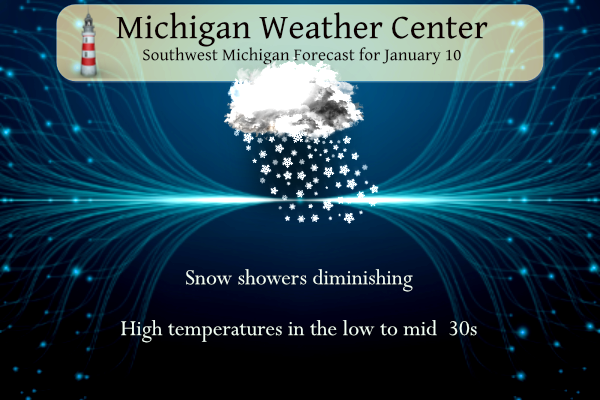
Snow showers will be winding down today before our next system which may bring widespread snow to the area Friday. The term bomb cyclone or bombogenesis is being thrown out there to spark our interest.
Bombogenesis, a term used by meteorologists, occurs when a midlatitude (the latitudes between the tropics and polar regions) cyclone rapidly intensifies, or strengthens, over a 24-hour period. This intensification is represented by a drop in millibars, a measurement of pressure used in meteorology. The intensification required to classify as “bombogenesis” varies by latitude. At 60 degrees latitude, it is a drop of at least 24 millibars (24 hectopascals) over 24 hours. At the latitude of New York City, the required pressure drop is about 17.8 millibars (17.8 hectopascals) over 24 hours.
Bombogenesis can happen when a cold air mass collides with a warm air mass, such as air over warm ocean waters. It is popularly referred to as a bomb cyclone. The system Friday could take shape as a classic Colorado Low. From there, the storm will track quickly northeast into the Great Lakes while undergoing rare rapid intensification. Forecasts are pointing towards 6+ inches of snow for the area with winds coming off Lake Michigan after its passage with additional lake effect snow. Welcome back to winter! So, stay tuned for further updates.
Forecast
Weather History
1982: Extreme arctic outbreak brings record cold temperatures and massive lake effect snow totals. Muskegon has their snowiest calendar day on record with 22 inches. This contributes to the all-time record monthly snowfall of 102.4 inches (8 and a half feet!) at Muskegon for January 1982.
On January 10, 2009, a strong low pressure system tracked east along the Ohio River, producing 6 to 9 inches of snow along and south of M-59. Snowfall totals quickly tapered off north of M-59. Some of the higher snowfall totals reported included Ann Arbor 7.9 inches, Brighton 9.0 inches, Carleton 8.5 inches, Ferndale 9.0 inches, and South Lyon 9.0 inches.
On January 10, 2004, the temperature in the cities of Bad Axe and Richmond dropped to -9 degrees. This turned out to be the coldest air of the season.
U.S.A and Global Events for January 10th:
1800: According to David Ludlum, Savannah, Georgia, received a foot and a half of snow and ten inches blanketed Charleston, SC. It was the heaviest snowfall of record for the immediate Coastal Plain of the southeastern U.S.
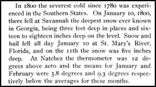
The image above is from the “Memorial History of Louisville from Its First Settlement to the Year 1896.” Pg. 24. Click HERE to read the book.
1949: Snow was reported in San Diego, California, for the first time since 1882. The snow was noted on some of the beaches in parts of the Los Angeles metropolitan area.
1973: A powerful F5 tornado struck San Justo, a town in the province of Santa Fe, Argentina, on January 10, 1973. At least 63 people were reported dead, and 350 were reported injured as it cut a 300-yard wide swath through the town.
1982: Bitterly cold weather was found across Illinois. Of the 109 weather reporting stations in the state, 48 of those reported lows of 20 degrees below zero or colder. Some of the most frigid temperatures included 27 below zero at Rockford, 26 below zero at Chicago, and 25 below zero at Kankakee and Peoria. The Freezer Bowl was played between the Cincinnati Bengals and the San Deigo Chargers in bitterly cold wind chills. The air temperature was −9 °F, but the wind chill, factoring in a sustained wind of 27 mph, was −37 °F. Click HERE for more information from Cincinnati.com
Forecast Discussion
...Snow winding down this morning...picking up again tonight.

Radar shows light snow beginning to diminish across the cwa; light
snow continued to fall over the entire cwa but visibilities were
improving. Latest model confirms our going forecast that light
snow will end this morning.

Latest surface analysis indicates the deep 975 mb low is over
northeast Lake Huron continuing to move away. As it does so,
winds will also diminish a bit.

The Winter Weather Advisory in effect over the central two rows of
counties expires at 7AM and over the northern two rows at 10AM;
this timing still seems on track.

Water vapor imagery shows the next short wave over eastern Wyoming
early this morning. This wave will make a beeline toward northern
IN/southern MI by this evening. As is typical of clipper type
systems, we`ll see a brief burst of snow as the short wave moves
through tonight and accumulations will be in the 1-3 inch
range...highest along the northwest lake shore where southwest
winds ahead of it may add a little lake enhancement. Most areas
will see 1-2 inches. The Thursday morning commute will be affected
by the falling snow and anyone traveling should allow some extra
time to reach their destination.

Light snow will diminish early afternoon Thursday. Since this
clipper is traveling more west to east, there won`t be a surge of
arctic air behind it like the traditional winter clippers than
travel from Alberta. Highs today and Thursday will be in the 30-35
degree range.

...Strong System Bringing Snow and Winds Friday into Saturday...

A negatively tilted trough will swing through the region Friday
into Saturday bringing with it a deepening low pressure system
that is anticipated to track through south central and southeast
Michigan. 500mb positive vorticity advection, 850mb warm air
advection and convergence with the low level jet, along with
colder air advecting into the region Friday morning will bring
support for snow. Depending on the low track there could be a
wintry mix for portions of the area, but this will be short lived
as colder air advects into the system. 250mb speed divergence will
aid in supporting the system as it moves through Friday night into
Saturday morning.

Ensembles are highlighting a greater than 60 percent chance of an
axis of 6+ inches over the forecast area along with mean wind
gusts Friday into Saturday of 30 to 45 mph with the highest gusts
Friday night into Saturday morning. There is still some spread
between the 25th to 75th percentile due to some differences in the
overall low track and how fast cold air is ingested, but overall
hazardous conditions are looking more likely. Accumulating snow
and strong winds which could lead to power outages and dangerous
travel conditions. Keep up with the forecast and consider making
adjustments to any plans for Friday and Saturday.

...Winter is Here With Cold Temperatures and More Snow...

Much colder air than what we have seen moves in behind Saturday`s
snow with highs in the teens and lows in the single digits. Wind
chills around and below zero are also expected Sunday into next
week. With the colder temperatures also comes a supportive
environment for lake effect snow. With 850mb temperatures around
-18C, west to northwest winds, and lake surface temperatures
 around 6C we should see snow stick around likely through next
 week. This snow could get some added synoptic support as well
 with the upper level low remaining over Hudson Bay and rotating
 additional troughs through the region. Dress warm and keep the
 shovels and snow blowers ready.
Reed Timmer weather extremely Chaser calls for a big blizzard in Michigan with double digit snowfall and huge tornado outbreak in the south rutt roll!! InDY
Yes parts of MI will see a blizzard and double digit snowfall!
I hope I see better trends by tomorrow! Right now I see this storm trending the wrong direction!
Looks like we’re finally going to get a “wow-worthy” snowstorm. Local TV met said 4-8” for us but we’re close to the 6-10” line. GR to Ludington to TC 7-14”. Mt Pleasant to Alpena 15-20”.
Our other TV met didn’t go into as much detail. He said 10+” for us and everywhere to our north and northwest more than that. He didn’t put a numerical value for those areas but rather just used a darker color.
Lansing is going to be on the edge of lower snow totals and possible rain mixing in. I would like the low pressure to move a little bit more to the east!
No rain there is to much cold air with storm… Winter storm warnings tomorrow blizzard warnings Friday is my guest!! It’s going to get blizzard nuts around here …..DDDD INDY
You may be 100% correct, but I see the low trending to the NW which is not helpful! We will see how the track looks tomorrow!
Storm Team 8 says 10-16+ inches of snow
That seems a bit aggressive for a storm 2 days out, however if everything comes together it is certainly possible!
We shall see!
Breaking>>>>>I am seeing a wobble and trend of the main low pressure area moving more the West. If that trend continues we will see less snow! It needs to hold the line or move a little to the East!
Yes a slight northward movement would not be as favorable. Model trends will need to be watched closely.
The NAM is furthest north. Euro and GFS not much of a change.
Agreed and I do not want this to move any farther to the West!!
…WINTER STORM WATCH IN EFFECT FROM FRIDAY MORNING THROUGH
SATURDAY AFTERNOON…
* WHAT…Heavy snow in excess of 8 inches possible. Winds could
gust as high as 50 mph.
* WHERE…Portions of central, south central, southwest and west
central Michigan.
* WHEN…From Friday morning through Saturday afternoon.
WInter storm watch Here we go ….INDY
Standout point made in the NWS GR discussion:
“This system looks quite similar to the “Groundhog`s Day Blizzard” of February 2011 where 10-14 inches of snow fell in 8 hours or so with 40 mph winds.”
Winter Storm watch for all of us starting at 10 am Friday!!!
For Rocky:
“The associated sfc low looks to take a track over far SE Lower MI, which would support a nearly textbook track for the heaviest snow with the pivot point of isentropic ascent ahead of it, and deformation/trowal area through the heart of the area, including Grand Rapids.”
That would be a great track! My concern is this storm gets so would up it ends up tracking more to theEast! I hope it ends up over by Toledo/Detroit!
I meant to say more to the “West”.
One local met showed the rain/snow line very close to here. The other one showed it down to Jackson and Washtenaw counties.
Mark Torregrossa’s take:
https://www.youtube.com/watch?v=F8FiFxz6cEw&t=22s
I don’t like his video and I disagree with many of his points!
Agreed. I think he should stick to text based communication.
+1
Well looks like we could make up our (entire?) snowfall deficit over the next week. I am going to hold off on excitement until tomorrow afternoon just to be safe… but this storm is looking really promising!
No warm air is in sight! Now we are talking – some real WINTER weather is on tap! I love snowy winters! Keep it coming!
Winter Storm Watches posted for SW corner of Michigan and the counties around Saginaw Bay. NWS GR will follow suit shortly, I reckon.
You beat me to it…
The 12Z EURO still has some impressive snowfall totals! Get ready to rock n roll people!
https://www.pivotalweather.com/model.php?m=ecmwf_full&p=sn10_acc-imp&rh=2024011012&fh=240
12Z Euro continues the same drumbeat as it has been. Deepens the low to 970mb passing just SE of Grand Rapids. Prints out totals 12 inches or more for the city. GFS is fairly similar.
Storm team 8 at noon said looks like a big storm for West Michigan.
Who would have thought! You mean the pattern is changing to a colder, snowy patter? Incredible!
I have to say the B word is looking highly likely for Friday-Tuesday is called the great and powerful Blizzard!! Get to the store and grab more!! Woo to the woo! Let’s Go ! INDY
Update from NWS GR:
“Not too much new to report at this time. Bulk of the snow with the incoming clipper system falls during the overnight through mid-morning Thursday, squarely impacting the morning commute. We`re not planning any headlines with this system at this time given the fast movement of the system and lower end 1-3″ amounts, but will be considering a watch issuance for the big weekend system.”
I just watched this video on the up coming snow… he did a nice job.
https://www.youtube.com/watch?v=ZRNgy00j2eA
Thanks for the link. I agree. He does a nice job. Subscribed. 🙂
No problem!!!
WEATHER ALERT>>>>>>>>>Get ready to rock! For those out there that are still slow walking the Friday storm you need to wake up! A major snowstorm will be hitting West MI on Friday/Saturday! Take it serious and start preparing now! The major hazards are; heavy snow. low visibility, strong winds, possible power outages and very bad travel conditions! Don’t say that weren’t warned!!
The possibility for power outages is possibly the most concerning portion of it aside from significant accums simply because the Arctic air that pours in behind this system. That would not be a good combo.
Another item of note is that subsequent to that storm, we may see our coldest temps that we’ve had in two years. Highs look to be only in the teens next week.
The latest 06Z Euro maintains the same track is been showing now for many runs. It brings the low down to 969mb. Models runs off the Euro/ GFS/NAM the rest of today into tomorrow will be most important.
We are only about 50 hours from the start of the event, so if the afternoon runs are consistent, I think a potential watch could be issued this afternoon. Typically a watch is issued 48 hours head of an event. If there is still uncertainty then I’m thinking they will hold off until the AM.
Clearly there is a good chance of a significant storm atm. Things could change, but that’s what a watch is for
Spot on. I agree with you if 12Z models look consistent it possible a watch could be posted this afternoon. Otherwise as you said if they are unsure then probably around 3am Thursday.
Several inches (maybe 4?) of a wet heavy snow. Looks really nice out this morning
We ended up with 7-8” here in NE Montcalm county. Schools are cancelled today.
We get maybe 2-3” here in Portland. I haven’t measured yet. Schools closed here to. Roads may be icy here though under the snow since we changed to rain for a while. Glad I shoveled the slush off last night.
You were certainly in the sweet spot. We had nothing on the ground at sundown last night. Woke this morning to close to 2″ of heavy wet snow. The grass is almost covered, but the roads are in decent shape. No school closures in this immediate area – some in the rural sections of neighboring counties.
Yesterday had the 1st major snowfall of the winter season. It was a very wet snowfall and Grand Rapids set a new record for the wettest January 9th with 0.94” with a reported snowfall of 4.1” Here in MBY this morning I have 3” of very wet snow on the ground. For today the average H/L is 31/19 the record high of 57 was set in 1975 and the record low of -19 was set in 1942. The record snowfall of 5.2” fell in 1999. The most on the ground of 17” was in 1999 and 1979. Last year the… Read more »
This no doubt has the potential to be a big time storm for us. The GFS has come into agreement more with the Euro on the overnight runs so that increases confidence.
The WPC snowfall probabilities gives Grand Rapids an 80-90% chance of exceeding 8” and a 50-60% chance of exceeding 12”
I will point out some of this includes the 1-3” forecasted before the main event.