Today and tomorrow don’t look to be very fun situations if you are out and about. With temperatures a bit above freezing the snow will be very wet and heavy today then freezing into a solid mass when temperatures begin falling tonight and tomorrow.
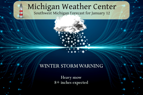
Winter Storm Warning
...WINTER STORM WARNING REMAINS IN EFFECT FROM 10 AM THIS MORNING
TO 7 PM EST SATURDAY...

* WHAT...Heavy snow and high winds expected. Total snow
  accumulations of 8 to 13 inches. Winds gusting as high as 50
  mph.

* WHERE...Portions of central, south central, southwest and west
  central Michigan.

* WHEN...From 10 AM this morning to 7 PM EST Saturday.

* IMPACTS...Travel could be very difficult and perhaps impossible
  by Friday night. Widespread blowing snow could significantly
  reduce visibility. The hazardous conditions will impact the
  Friday evening commute. Gusty winds could bring down tree
  branches and cause power outages.
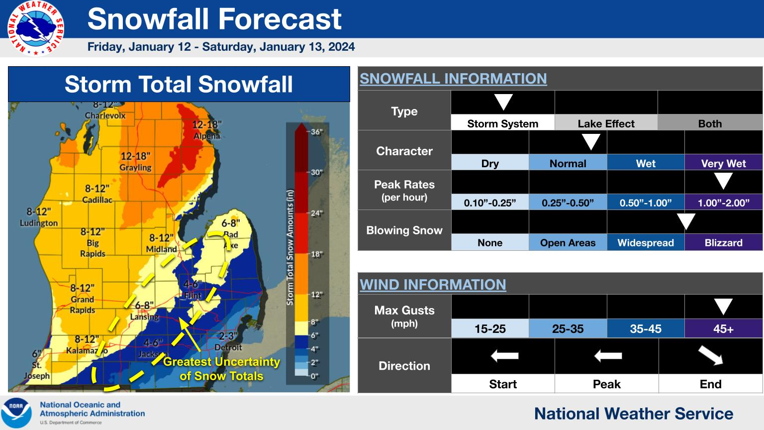
Heavy snow and strong winds are expected for portions of Michigan starting Friday morning and continuing into Saturday. The main concerns are wind gusts of 30 to 45 mph paired with heavy snow causing blowing and drifting snow, whiteout conditions, power outages, and hazardous travel conditions. Most accumulations are during Friday afternoon and night with impacts to the evening commute likely. Locally higher amounts are possible.

Snow starts late this morning and into the afternoon with the heaviest snowfall expected during the afternoon and evening commute! Strong easterly winds gusting to 50 mph at times are also expected today. These winds paired with the snowfall will likely cause near zero visibilities, snow covered roads, blowing and drifting snow, and could also cause some power outages. Avoid travel if possible.
Forecast
Forecast Discussion
-Significant Winter Storm Today Through Saturday

Bottom line up front is that no significant changes have occurred
with this forecast package. All headlines remain as is with a Winter
Storm Warning in effect from mid-morning Friday through Saturday
Evening except for Jackson County (who is under a winter weather
advisory).

The overall synoptic pattern causing this winter storm evolves from
a upper-level jet rounding the base of a robust upper-level wave,
and coupling its left exit region with the right entrance region of
a second upper-level jet over the central Great Lakes region. Lower
in the atmosphere, a 500 mb trough closes and deepens as it ejects
northeast, driving a surface low across lower Michigan. The
significant degree of upper-level forcing causes the surface low to
rapidly deepen to 970-975mb as it passes in the vicinity of KLAN
tonight.

The significant gradient associated with the robust surface and
upper-level lows creates a potent low-level jet of 50-60 knots from
the southeast at 850 mb today, advecting moisture into the state via
the warm conveyor belt, and given the cooler air mass than earlier
this week, precipitation is mainly set to fall as snow. All of these
factors are expected to combine to create a significant winter storm
across the region today through Saturday.

-Significant Accumulating Snow Expected

Initial snowfall will likely struggle against a layer of low-level
dry air this morning, but by late morning into early afternoon, snow
coverage and intensity increase quickly due to warm air advection
with the 50-60 knot low level jet and associated isentropic upglide.
This will cause conditions to seem benign to start the day but
quickly deteriorate as the day goes on.

A large portion of the forecasted snowfall is expected this
afternoon and evening associated with the TROWAL airstream and
deformation band pivoting around the surface low as it low advances
into the region. Combined with high omega values in the DGZ, this is
forecasted to bring snowfall rates as high as 1-2 inches per hour,
and possibly even some thunder depending on the degree of elevated
instability. In terms of water content, this will be a wetter snow,
especially across the southern CWA where temperatures will be warmer.

The one caveat to this lies across our southeastern forecast area,
where low-level warm air is forecast to nose in for a few hours this
evening south and east of I69 (such as parts of Ingham and Jackson
counties). This will cause snow to mix with or change over to
rainfall for a time before cold air wraps back in, cutting down on
snow totals in this area. The extent to which this occurs provides
some uncertainty in exact snow totals and the placement of the
snowfall gradient across the southeast CWA.

As winds shift to northwesterly Friday into Saturday, synoptic snow
from the storm becomes augmented with lake effect snowfall given the
flow off the lake. The cold air intrusion, in addition to initiating
lake enhancement given the produced instability, also causes a drier
and fluffier snow character which becomes easier to blow around.
Additional accumulations Saturday into Saturday night are expected as
given the wind field, lake enhancement will penetrate well inland.
Headlines in some form will likely be needed after the current
headlines expire to cover this.

Overall this supports a significant snowfall of 8-14 inches north
and west of I69 with locally higher totals possible. South and east
of I69, the warm air intrusion will cut down on totals to generally
fall in the 5-9 inch range, lowest across the extreme southeast CWA.
The snow will promote significant travel impacts for the Friday
evening commute and dangerous road conditions.

-Windy Conditions Bring Potential of Reduced Visibilities/Power
Outages

The other concern with this system is the winds associated with the
strong kinematic field. Winds will be in the 15-30 mph range from
the southeast during the day Friday with gusts to 45-50 mph. A brief
lull in winds is expected Friday night as the low passes overhead,
similar to the eye of a hurricane. Winds then sharply turn to be
from the northwest Friday night causing an increase in mixing,
albeit with the low level jet being weaker on the western side of
the storm. This keeps the potential for 40-45 mph gusts during the
day on Saturday.

Between the heavy snow and gusty winds widespread blowing and
drifting snow is expected and will cause visibilities to fall near
zero at times. Combined with accumulating snow, this will create
significant travel impacts. Travel is not recommended during the
storm, especially Friday afternoon and evening.

The other concern between the wet snow character and gusty winds is
power outages. At least scattered power outages are possible as the
wet snow sticks to trees. This is a concern given the colder weather
arriving in the long term.

- Lake Effect Snow Saturday Night into Sunday Night

Lake effect snow Saturday night into Sunday will make it difficult
to recover from the winter storm for areas mainly along and west of
131.

There will still be some synoptic support as the lake effect machine
starts to churn with 850mb temperatures around -15C dropping to
around -19C Saturday night into Sunday morning and lake surface
temperatures around 6C. We`ll have a westerly fetch around 80 miles
and the dendritic growth zone will only be a couple thousand feet
above the surface with low level laps rates providing a shallow
layer of instability. 925 mb flow will be around 30 knots which will
help bring snow farther inland. The best accumulations at this time
will be along and west of 131 where around 6 inches will be possible
through Sunday morning. Farther east amounts decrease with a couple
of inches possible toward the 127 corridor. Westerly winds will
remain breezy during this timeframe as well with gusts around 25-30
mph which could cause some additional blowing and drifting of snow.
Snowfall rates decrease as the synoptic support drops off Sunday
afternoon into Monday, but light snow will continue to accumulate
with another couple inches possible through Sunday night. We`ll have
to watch the I-94 and I-96 corridors as there looks to be an area of
surface convergence that meanders throughout the day Sunday and
Sunday night. This could be the focus for some better snowfall rates
and accumulations.

- Bitter Cold and Additional Lake Effect Snow Next Week

Highs Monday through the middle of next week will be in the teens
with lows in the single digits. Wind chills drop below 0 and look to
remain below zero through the first half of the week before
temperatures warm up into the upper teens to low 20s for Thursday
and Friday. Wind chills, however, remain in the single digits and
fall to around zero each night. Power outages will be a concern
leading into this cold period. If you are without power during the
cold make sure to be careful with heat sources. If you don`t have a
warm place to go to, you can stay warm by bundling up, keeping doors
closed, and plugging up any cracks in the doors with towels.

Lake effect snow will also continue Monday, but accumulations look
to remain light and closer to the lakeshore. Another shortwave
trough is expected to move through Monday night into Tuesday which
could amplify the lake effect snow. A lull in the lake effect snow
is possible Wednesday, but there isn`t enough confidence to lower
PoPs at this time. Additional troughing could bring more snow to the
area for the end of the work week.
Wowee! Wowee! Wowee! What a storm and now more system snow, lake enhanced snow, lake effect snow, wind and cold! It could not be better! Rock n rolllll!
A very pleasant evening…at this moment. Cleared the driveway. My Barometer is showing 28.78 at 11:22pm. Lowest reading at my home in three years. Dead calm outside. Not at all happy with the winds this storm could generate.
Same here. Calm and nothing but a couple of flurries in the past four hours.
34 degrees here. Just went out and cleared 3” of the wettest, most compact, heaviest snow imaginable. We’ve had two hours of hardly any wind or snowfall. I figured that I’d get the heavy stuff cleared before the light fluffy stuff comes later.
What a storm and what a pattern! Incredible!
Lightning on radar southeast of Flint
Also lightning near Detroit
The snow intensity is picking up! Near blizzard conditions as we speak! Wow!!!!
We’re not getting that here. Wind mph has dropped down in the teens. Looks like center of the low is entering SSW Michigan now.
Definitely has that “winter storm feel” right now. Just went for a walk, it was great!
Nice
Local TV met bumped our forecast accumulation to anywhere from 5 to 10″ by Sunday. The wind has really increased over the past two hours. I think will be interesting when the “eye” moves overhead later tonight.
Well a family member of mine just lost power in the Wyoming area and I can also report I just lost a white pine branch. Just came crashing down
Wow, wow, wow, wow, just WOW! We are getting absolutely pelted with snow and the radar is filling in fast! ! My updated point forecast gives me 14 inches through Saturday night! What an AMAZING and INCREDIBLE storm! Anyone that is going outside tonight needs to have an emergency kit and be extremely careful! Holy cow what a MONSTER storm! It will go into the record books! Mark it down and stay safe!
It is now up to 16 inches!!!!!!!!!
Just wait till the wind and lake effect cranks tomorrow! Big daddy storm!
Roads are in terrible shape! Highly recommended to stay off roads!
+ 1 Million!
Going to be hard to measure this snow…very wet.
Agreed. Nearly impossible. The snow is now starting to stick to the paved surfaces here.
At 3PM here in MBY there is now moderate snow falling with a temperature of 32. The road now has coating of snow on it the driveway about the same On the snowboard there is now 0.5” of new snow and a total of 3”. I will be going into work shortly so I will not have any updates until around 10PM. Will have to see what the afternoon NWS update looks like.
Slim
Hey!…here’s some light snow. Had to get started sometime.
The 12z EURO is now loading and the low in not as deep as it was earlier. It now has the deepest at 975 in the Alpena area. Not sure how this will play out for the total snowfall amounts. At this time there is now some light snow falling here. Will let you know when it picks up. As for the school closings well what can I say. The kids get a long weekend and now can help with any clean up if needed LOL as if that will happen.
Slim
Np with a reading of 975, however it looks to me that the low may travel farther North as it gets near the MI/IN border – that could lower snow totals?
I say don’t get caught up in each model run anymore. The storm is here and just kick back and let it play out. Whatever happens happens. I’ll leave any forecast adjustments and updates to NWS GR. Just my take though.
Rock on Kyle! Keep up the good work!
The dry air is starting to saturate and the snow will be moving in soon! Incredible!
Man, my kids could have gotten at least a half day in at school today!
Almost a full day but the time the heavy snow arrives!
Same. It just started here. Better safe than sorry. Ours only had two snow days last year and this is first for this year. Oh well, a nice four day weekend for them.
There still looks to be a lot of dry air in our area at this time. Radar shows a lot of heavy rain to our south. The current air temperature here is 34. The wind has picked up. The updated discussion now have a kind of dry slot coming in after 10PM but so far are sticking to their current forecast. At this time it is cloudy windy and 34.
Slim
Yes, they predicted the dry air, but soon the dry air will be history and we will be getting absolutely hammered with heavy snow! Patience, but wait till around 3 pm and then bam!
The dry air is saturating as we speak! Get ready for the snow!
In looking at the current radar there is a small area of light snow moving into Michigan. All of the current heavier snow is off to the west heading north. There is a large “dry” area to our south than some a large area of rain to the south of that dry area.
Slim
We will heavy snow across our area by 2 or 3 pm! Get ready!
Get ready or ROCK! My point forecast shows 14 inches of snow by Saturday night with 30 MPH winds! What a storm! Can you say BIG Daddy?
Wow – less than an inch or two of snow forecasted for parts of SE Michigan now? Crazy dispersion with this storm.
The wind is beginning to pick up with a few snowflakes in the air.
The current point-and-click forecast gives me 16″ from now through Sunday. So clearly not as big as the Christmas Blizzard or Groundhogs Blizzard, but we have that intense cold behind the system that will make it hard to clear roads through next week. Along with heating issues if people lose power. Either way, still looks like a healthy winter storm!
I measured close to 20” at my house in Byron Center during the 2011 blizzard and was completely snowed in for a while.
I don’t know if you guys were around for the late 70s blizzard, everything was closed including the freeways with 19 ft drifts.
I was not around in the late 70s but I would love to experience a storm like that! I have pictures from my grandma from the blizzard. I hang onto them.
remember, we had no internet or cell phones back then…
That was my first winter on this side of the state. I will never forget it.
I was not but my parents were. They’ve told me many crazy stories. For me personally, the 2011 is still the biggest
Yep. I was seven. That storm is the benchmark for me.
Is it finally winter? What a run we had! I can deal with a 4-6 week winter.
From the NWS Gaylord office
 ?4e4741264910a6470310f23abb410b9f
Blizzard conditions are expected across many areas of northern lower Michigan along and east of I-75 this evening and tonight. Highest snowfall totals of 10-15” are expected for this area where localized totals near 18” cannot be ruled out. Strong wind gusts of 35-50+ mph will combine with high snowfall rates of 1-2” per hour to create near-zero visibility and produce significant drifting on roadways. Travel is strongly discouraged this evening and tonight as dangerous driving conditions set in, so be sure to plan accordingly.
I’m glad I live downstate. That will be intense.
Same here Mark! Don’t want any of that!
Alpena is going to get the wind off the lake (east wind) with lake enhancement and strong gusts. Especially if the low dips closer to 970, going to be really intense there for sure
I wish I was there! Sounds like fun!
This is from the Chicago NWS office
Here’s a timeline of expected winter weather impacts through Sunday, with a major winter storm causing dangerous travel through early Saturday, followed by snow showers, strong winds, and blowing snow on Saturday, and then the arrival of the first bitterly cold air mass of the season later Saturday into Sunday.
rocky must have passed in his sleep, or he would be blowing up the thread with the glory of this storm. LOL I do have concerns for my daughter and others who have to be on the road tonight for work… Drive safe everyone.
wow! just wow! (for Rocky)
I see him just sitting in his front yard right now just staring at the sky waiting for the snowstorm of the century!
At 7:40 AM the temperature here in MBY is 31 with cloudy skies. The current snow depth here is 2.5″. I have a snow board set up a yard stick for measuring the snowfall. I also have several snow shovels some are OK while a couple are not that good. I have gas for the snowblower so I guess I am about as ready as I can get for what may or may not come.
Slim
For us older folks – take care shoveling heavy wet snow, pace yourself. In regards to snowblowers, sometimes they struggle with cement like snow, that is one of the reasons I bought a plow and chains for my lawn tractor.
We’re stocked up on provisions and need not to leave the house this weekend. I probably won’t even touch the driveway until tomorrow, maybe Sunday.
I saw something interesting on the local news. The met said that the winds will be so strong tomorrow that a lake effect band could stretch from the Lake Michigan coastline all the way to upstate New York.
Wow Mark… that is crazy about the lake effect!!!
I read someone put I am stocked in my French toast ingredients (Milk, eggs, bread). It made me laugh.
Like Bernie said keep those on the roads in your prayers!!!
Good advise for us older folks(at least according to AARP), that’s why I’m going to defer all of the shoveling to my wife. She’s 3 years younger than me. Just to be on the safe side.
As we wait for the snow to start. The official H/L yesterday at Grand Rapids was 37/30 there was 0.9” of snowfall. The day started with 5” on the ground. There was 6% of possible sunshine. For today the official H/L is 31/19 the record high of 57 was in 2013 and the record low of -14 was set in 1918. 1918 also seen the record snow fall of 10.0” at Grand Rapids and the record snowfall of 8.0” at Muskegon at Lansing the record snowfall for today is 5.0” in 1867. The most snow on the ground was 22”… Read more »