 We will have a wild and blustery day today for a good portion of Michigan. The areas in pink will meet warning criteria the blue areas are where advisories are in place.
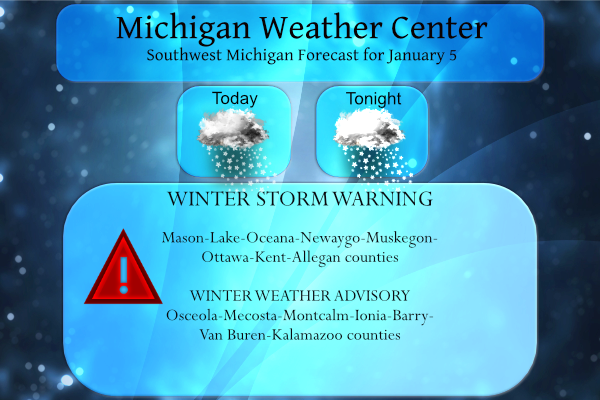
Heavy lake effect snow is expected in the warning area. Total snow accumulations of 4 to 10 inches. Winds gusting as high as 45 mph, mainly from Muskegon south.
Total snow accumulations of 1 to 4 inches are expected in the advisory area with winds gusting as high as 45 mph, mainly south of Howard City and Mt Pleasant.
Travel in western Lower Michigan will be greatly impacted Wednesday by snow showers, heavy at times, areas of blowing snow, and slick roads. Near blizzard conditions with whiteouts may occur and a few power outages are possible.
Winds will diminish on Wednesday night but lake effect snow will continue heavy at times mainly near and west of Highway 131.
Localized heavy lake effect snow and hazardous travel conditions could continue into Thursday and Thursday night for portions of western Lower Michigan near and west of Highway 131, before diminishing for the weekend.
Arctic air and significant lake effect snow may return again for Sunday night and Monday.
We have 34˜ at 5 am here in Otsego with the winds picking up from the SW. Yesterday’s high was 34° the low 17°.
Weather History for SW Michigan
January 2
1876: Record highs are set for the third day in a row at Lansing and Detroit as the temperature reaches 62 degrees at both locations.
1999: A powerful winter storm gets underway with heavy snow and high winds shutting down travel for the next several days.
January 3
1897: Warm and wet weather prevails as a cold front approaches. High temperatures in the 50s are followed by heavy rain. This is the wettest January day on record at Muskegon, with nearly 5 inches of rain.
1918: The temperature falls to a record low of 16 below zero at Muskegon during one of the coldest months on record in Lower Michigan.
January 4
1981: Arctic air is firmly entrenched across Lower Michigan with extremely cold temperatures prevailing for the first half of the month. Eight of the first twelve days of the month fall below zero at Lansing. This is the coldest morning with a low of 29 below zero. This is the all-time low for the month of January at Lansing and the coldest temperature of the 20th century there. The temperature falls to 20 below zero at Grand Rapids and 15 below at Mount Pleasant.
1999: West Michigan is digging out from 1 to 2 feet of snow, with drifts of several feet as the Blizzard of 1999 slowly winds down. Lake effect snow will continue the next several days, however.
January 5
1912: Arctic air dominates Lower Michigan during the coldest January on record. Muskegon plunges to 12 below zero for a record low for the date.
1998: Moist southerly flow brings warm and wet weather to Lower Michigan. Highs in the 50s follow morning lows in the 40s as several days of thawing weather are observed during the first week of January.
1946: Record highs are set for the second day in a row across Lower Michigan as temperatures reach the mid and upper 50s.
January 6
1999: Heavy snow piles up on top of the snow dropped during the blizzard a few days earlier. Another 9 inches of snow at Muskegon brings the snow total on the ground to 30 inches, with snowdrifts several feet high. This will be the snowiest January on record at Grand Rapids with 46.8 inches of snow and Lansing with 34.6 inches.
2014: A three-day siege of heavy snow and extreme cold begins. Frequent white-out conditions and temperatures hovering near zero make travel hazardous and at times almost impossible. The phrase ‘polar vortex’ enters the weather lexicon during this time.
January 7
1942: Record cold high temperatures occur as arctic high pressure prevails. The high temperature is only 4 degrees at Grand Rapids and 6 at Muskegon. At Lansing, the thermometer struggles to reach the zero mark during the day, with a frigid northwest wind making it feel even colder
1988: An arctic blast brings several days of sub-zero cold to Lower Michigan, including record lows this morning of 15 below zero at Grand Rapids and 11 below at Muskegon.
January 8
1880: Temperatures remain above freezing for the fifth consecutive day during the warmest January on record at Lansing.
1965: Temperatures soar to record highs of 59 degrees at Grand Rapids and Lansing and 55 degrees at Muskegon. A cold front moves through and temperatures will only reach the 20s the next day.
Weather History for SE Michigan
January 2
On January 2, 1999, a blizzard hit southeast Michigan and continued into the early morning hours of the 3rd. Detroit Metro Airport received 11.3 inches, Flint had 8.5 inches and Tri-Cities Airport in Freeland received 13.2 inches. Between 10 and 15 inches of snow fell over many areas south of M-59, and between 5 to 13 inches across the Saginaw Valley and Thumb regions.
January 3
On January 3, 1879, the second day in a row of record lows was reported at Detroit. Today the temperature was a cold 15 degrees below zero.
January 4
On January 4, 2016, lake effect snow developed along the shoreline of Lake Huron. While most locations did not measure snow, the eastern shoreline of the Thumb received 6 to 10 inches. A second snow band developed over Saginaw Bay and dumped 9 inches in the Saginaw Area. However, the snow band was so narrow that MBS airport recorded only a trace.
Also, on January 4, 1997, the temperature rose to 61 degrees in Flint and in Detroit. The normal high temperature for January 4 is only 30 degrees!
January 5
On January 5, 2014, a strengthening low-pressure system passed just southeast of the area and dropped significant snowfall across all of Southeast Michigan. The heaviest snow fell along the I-69 corridor where 14-18 inches was reported, including 17.1 at Flint – their 3rd largest snowstorm on record! Detroit measured 10.6 inches, good for its 24th largest snowfall on record, while Saginaw reported 8.8 inches. In addition, the National Weather Service office in White Lake measured 14.6 inches, the largest snowfall in its abbreviated climate record which began in 1995.
Also, on January 5, 2005, the city of Saline in Washtenaw County was hit with a snowstorm and received a total of 8.5 inches of snow. This snowstorm lasted through the 6th.
January 6
On January 6, 1912, the temperature in Detroit did not get above 5 degrees. The same was true on the previous day (January 5th).
January 7
On January 7, 2014, Southeast Michigan was amidst a 3-day period of record to near-record cold temperatures. Record lows were recorded at Detroit, Flint, and Saginaw. Detroit and Flint each fell to -14 degrees while Saginaw fell to -11 degrees. The coldest spot in Southeast Michigan was the city of Saline in Washtenaw County which fell to -23 degrees! The high temperature in Detroit on this day reached only -1 making it one of the coldest days on record for the city. Widespread wind chills in the -30s and -40s were recorded.
Also on January 7, 2008, record highs were set across Southeast Michigan. Detroit reached 64, Flint 61, and Saginaw 59. These temperatures were only 3 to 4 degrees off of the all-time January high temperatures. Later during the evening, thunderstorms moved across the region. Some of these storms were severe in Midland, Washtenaw and Monroe Counties! Since 1986 only two other January have had severe weather, 1990 and 1996.
January 8
On January 8, 2005, the city of Samaria in Monroe County received 6.0 inches of snow when a snowstorm hit the area.
 In my travels, I talk to a lot of people about the weather. The main question I get in the winter is how much snow will any particular area get from a storm or lake effect. I can give estimates however there is a lot of variability due to storm tracks, wind speed and wind direction along with many other factors.
My daughter made this shirt for me, yes that is me for the few who have seen me from this blog. Last year she made me a stuffed weather pig with interchangeable weather symbols. She makes a variety of stuffed animals from scratch and is also a great artist. She has made the much-requested and rare Freddie Mercury doll (the frontman for Queen). You can see some of her stuff on Facebook.
I have the required mustache but have gone a step further with the beard. I have had the mustache since I could grow one.
So, if you see this bearded gentleman around your area I would gladly talk to you about the weather or just about any other topic you want to talk about. Yes, the shirt does make me look fat… 🙂
The outfit is my typical retiree stay-at-home-work clothes. I have been retired going on four years now…
Forecast Discussion
No changes at this point to winter headlines but the 00Z guidance
and upstream trends indicates a slightly later start to the heavier
snows, more toward 15Z. Also the winds look a bit less today due
to a slightly more srn track of the sfc low across nrn Lwr MI.

Max wind gusts today now look to be around 40 mph, and mainly just
south of a MKG to MOP line. Peak intensity in wind and highest
potential for whiteouts will be in the afternoon and early evening
hours. Risk of power outages does not look particularly high, but
still enough wind to create blowing snow and occasional
whiteout conditions.

The Arctic front has crossed the Mississippi River as of 3 am and is
expected to arrive in west Michigan from the southwest shortly
after daybreak. Expect to see a rapid uptick in LES intensity and
coverage as this occurs with low level cold air pouring in across
the lake.

Even though the early morning commute period looks to be mostly
okay, road/travel conditions will deteriorate significantly later
this morning as the current above freezing temperatures (mid 30s)
drop abruptly into the lower to mid 20s and snow quickly coats the
ground. This is a perfect recipe for icy/treacherous conditions to
develop suddenly which combined with the greatly reduced
visibilities could lead to numerous traffic incidents.

After today and tonight`s more widespread and synoptically enhanced
multi-banded snow showers - spread out by the stronger winds -
the character of the lake effect will change. Dominant banding
should become the preferred mode for Thursday and Thursday night,
and lake aggregate/mesoscale effects will probably influence
pressure, wind, and temp fields.

This creates uncertainties in where/when the dominant bands set up
and persist, but there may be some rather interesting meso features
rotating through the region Thur/Thur ngt - with increased risk
for localized 1-2 inch per hour snows. By Friday there could
easily be few locations in wrn Lwr MI that receive well over a
foot of new snow.

Further refinement/adjustment to warning counties undoubtedly will
be needed in later fcst updates once the wind direction eventually
veers/shifts to the northwest/north with the passage of a sfc
trough. CAMs are not in good agreement as to when that happens,
with the ARW and HRRR suggesting it occurring as early as tonight,
but NAMNest/Canadian solutions holding off more until Thursday
night. Some solutions indicate that a healthy/lengthy I-96 or I-94
convergence band will be in play later tonight into Thursday.

At some point Van Buren County and perhaps Kalamazoo County will
need to be in a warning once dominant NW flow banding finally sets
up. At the same time the snow will be shutting down for
Kent/Newaygo/Lake Counties (possibly others too), and they may
need to be removed from headlines.

Heavy lake effect snow finally shuts down later Friday as
persistent upper low trough lifts out and sfc ridging builds in.

The frontal System has already begun to cross Lake Michigan and as this front hits the shores of Michigan the snow showers will couple with the already gusty winds to rapidly reduce conditions across Western Michigan. Expect conditions to rapidly deteriorate this morning. The snow showers will intensity in the western counties and continue through the day. The winds will remain gusty, upwards of 45 mph through the first half of the evening.
What a storm! Wow!
MV I like the shirt on you that your daughter made you. Wow it is hard to believe you have been retired almost 4 years. Time flies. Well today reminds me of an old fashion winter day! Lots of snow!! I think I have nearly 10 inches here and the drifts are higher. My little dog who is 15 yrs old is not sure he likes winter this year. He loves it when the sun is out or he can find a nice warm sun puddle in the house. My grandson ran to the grocery store with me yesterday to… Read more »
Our local.school is closed tomorrow smart move roads are impossible to drive down ..InDY
Picked up maybe about a couple inches at my house. Little bit of drifting, not to bad. Different story on the west side. I have been all over Ottawa County today making deliveries and it was very challenging. Whiteout condition in some areas. Drifts knee deep
New daily snowfall record for GR and guess what its still snowing incredible…InDY
GR will be setting a daily snowfall record today! Who would have thought? Don’t worry, some will be saying this storm was a bust and no big deal! What a joke!
This is a monster storm! GR is still getting pummeled with snow, snow and more snow! Enjoy!
12 inch drifts out in my area crazy …InDY
This is an awesome winter day! I could use one of these at least 2 times per week for months on end! Bring it!
Including the cities of South Haven and Kalamazoo
333 PM EST Wed Jan 5 2022
…WINTER STORM WARNING IN EFFECT UNTIL 10 AM EST FRIDAY…
* WHAT…Heavy snow. Additional snow accumulations of 4 to 16
inches. Winds gusting as high as 45 mph.
* WHERE…Van Buren and Kalamazoo counties.
16″???? WOW!
Welcome to above average snowfall Grand Rapids for the young Winter season…Incredible….InDY
Who would have thought?
I just took some measurements and here I have between 4 and 11″ and there is heavy snow falling at this time.
Slim
I picked up a extra dozen eggs more milk and loaf of bread yesterday just in case we get snowed in …This storm means business..Incredible…InDY
GR is in the sweet spot right now and it looks to stay that way! Get ready for huge snowfall totals! Rock n roll will never die!
I have a good foot drift in my driveway this storm means business….InDY
It has been snowing moderate/heavy since around 11AM here. So 3 hours. And I measured about 2.1 inches at 1:30. The snowfall rate has remained the same so I’d estimate just over 3 inches here.
I just measured 4.5 inches. This is the heaviest it has been so far.
Now 5.5
… so basically a sustained inch per hour rate so far
Not much snow so far here so far (less than an inch forecasted for this area). But what has fallen is blowing like crazy. That wind is kicking!
Not much snow so far here so far (less than an inch forecasted for this area). But what has fallen is blowing like crazy. That wind is kicking!
Still getting moderate to heavy snow fall here. The snow flake size is rather good it is not as windy as it was. In the yard I have between 6″ and a trace of snow depending on location. The temperature here is now at 25. That is between 10 and 15° warmer than on the other side of the lake.
Slim
What a storm!!!! Don’t worry the warm weather fanatics will be commenting that the storm is not that bad! Ya right! This is a monster winter snow, wind and cold event! Enjoy!
It is definitely getting rocky up here! We are getting absolutely pummeled with snow and low visibilities! Incredible storm so far!
At this time getting moderate to at times heavy snow falling here. Looking out at the driveway it don’t look to have much snow on it at this time. At the airport they had a report of heavy snow at their last report. They reported west winds of 22 MPH with gust up to 30. At this time the criteria here dose not meet that of blizzard conditions. The current temperature here is 26 that last report out of GRR was 24.
Slim
Seeing yellows on radar clould it be thunder snow?? I am getting blizzard conditions out in my hood now wow to the wow who knew ??InDY…
Current conditions snowfall is picking up right now and the winds are rocky hunker down and stay with MV’s best…Let it snow let it snow ….InDY
With a slightly more southerly track of the low and maybe a bit slower as well the start of the potential heaver snow fall and winds have been pushed back. The winds here have just picked up and at this time I am getting a snow/rain mix with a temperature of 32. The temperature fell to 30 then went up to as high as 35 overnight. We will see how this plays out thru the day.
Slim
The snow intensity is picking up as we speak! Rock n roll!
Based on the NWS discussion (and aviation update) it looks like the heavier snow will start around 15-16z, or 10-11am. So a bit later than what the models showed yesterday, around sunrise at 8am.
Also we are down to 32 degrees at GR. But still a bit warm atm.
Blizzard conditions winter storm warnings above available snowfall winds gusty windchills in the teens schools closed who said no winter storms in sight ??? Incredible….InDY
Not us! The warm weather nuts are always delusional about winter and snowstorms!
Get ready GR! The RDB 6Z still shows 5 to 8 inches of snow! Wow and fantastic! Who wouldn’t love winter in West MI?
Looking good MV!!! THANKS AGAIN FOR RUNNING A FABULOUS BLOG ….INDY
+1
Our school just closed here we go …InDY
Great shirt, Slim! I work from home since the start of the pandemic and only go into the office 2-3x per month. My daily workwear is a tshirt and joggers (men’s version of yoga pants, which are the greatest thing since sliced bread), so I’m right there with ya.
My point forecast is calling maybe an inch at most, so it shouldn’t be too bad over here. To all my friends on the westside – be careful if you have to go out. It looks to be nasty starting this afternoon.
It is me in the photo, not Slim…
LOL. I was wiping the sleep out of my eyes when I viewed this and I thought to myself, man, Slim is really starting to look like MV. You know, like an old married couple start to look like each other after so many years together… 🙂
No Mark that is MV not me it the photo.
Slim
Slim is more svelte than me
He ain’t called Slim for nothin.
Extra credit for using “svelte.”
My typical work clothes vary drastically. Either my PJs or I dress up if I need to go into the office.
And nice beard MV, you don’t have that in your profile pic 😀