
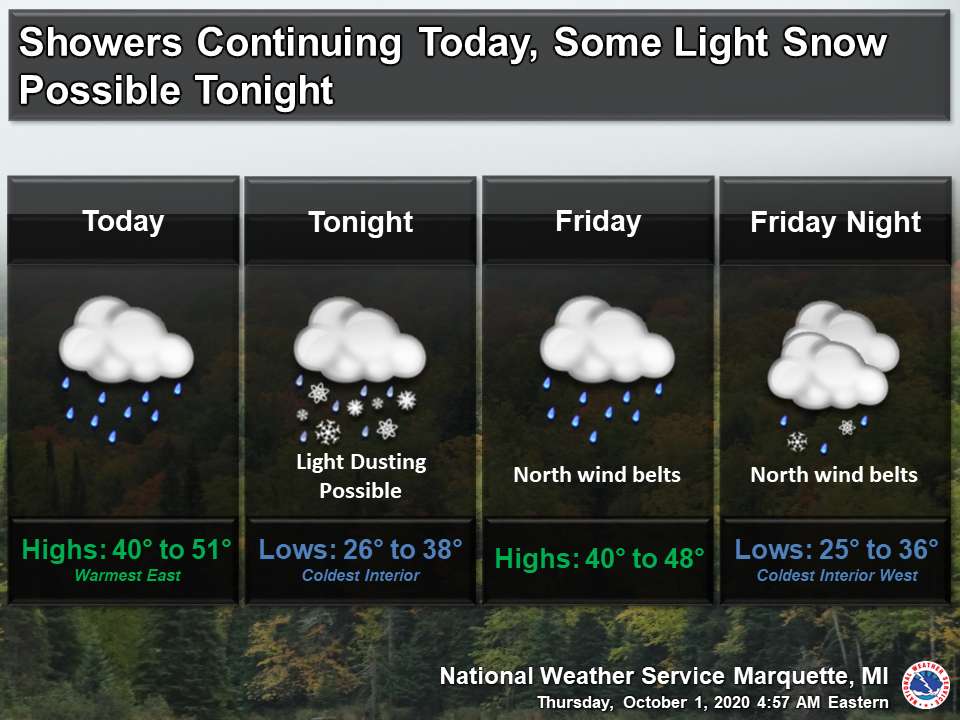
Summer has been swept away into fall of which we have had a good taste of the past few days. Our Marquette office is predicting a light dusting of snow overnight tonight and we of the southern clime shall receive more of the rain, wind and hail we received yesterday.
We received another .23 of an inch of rain yesterday and overnight which closes out September with 3.41 inches over half of which fell the past four days. Our total since May 1st is 21.31 inches. We will see rain off and on through most of the rest of the week then come into a dry trend next week. According to the CPC, we will see dryer than normal and slightly warmer than normal conditions over most of the rest of the month.
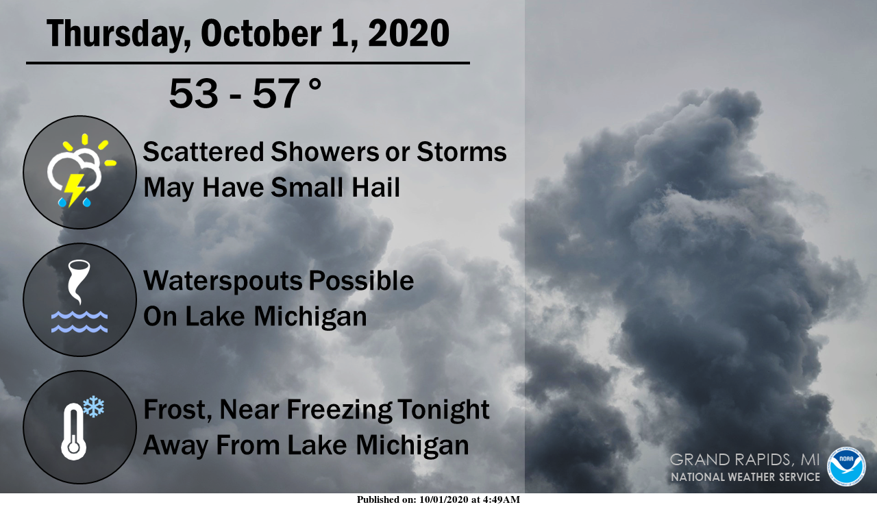
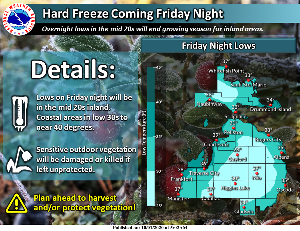
Showers (a few thunderstorms too) will become more numerous after sunrise today. Small hail will likely occur with some showers and storms. Waterspouts are possible over Lake Michigan. Cold temperatures and clearing skies Thursday and Friday nights will bring frost to much of Lower Michigan, and freezing temperatures to parts of Central and Northern Lower Michigan.
Michigan Forecast
[columns] [span6]
SW
[/span6][span6]
SE
[/span6][/columns]
[columns] [span6]
North
[/span6][span6]
U.P.
[/span6][/columns]
Forecast Discussion
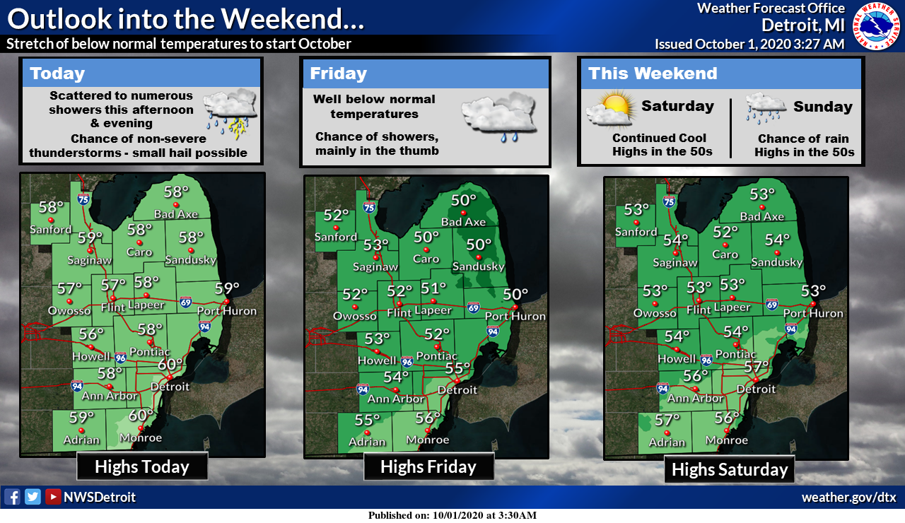
-- Showers with a few thunderstorms and small hail today--

One more day with thunderstorms, mostly small hail and a few water
spouts. We have one more shortwave and it`s associated surface
cold front to deal with today. The final jet core digging into the
western side of the upper trough over the Great Lakes sharpens up
the upper trough today as it rounds the base of the trough today.
With 500 mb temperatures below -25c we get 850 to 500 mb lapse
rates around 7c, hail cape between 300 and 500 j/kg and MU capes
in the 500 to 800 j/kg range today. Unlike yesterday through the
greatest instability and highest hail cape is closer to Lake
Michigan than yesterday.

Like yesterday there is strong lift in a saturated DGZ. Yesterday
the RAP model version of that did a great job of showing were and
when the best convection would be. Today it shows strong lift
north of Muskegon at 10 am, that then sinks south to Grand Rapids/
Lansing by 2 pm. By 4 pm is it widespread from South Haven
northeast to Grand Rapids to Alma. It is out of our CWA by 8 pm.

This agrees with the high resolution models in showing area with
over a half inch or rain today. Yesterday we had pockets of
rainfall over an inch. Today will be similar. Most areas will see
as least some rain today.


-- Frost/Freeze likely tonight and tomorrow night--

Tonight the passage of the surface cold front during this
afternoon turns winds to the north through about 20000 ft. That
will be enough to allow for clearing skies. However tonight we are
still inside the deep cold air aloft and the surface winds are
still cyclonicly curved. Still with north winds and dry air being
brought in skies should clear enough for frost. A freeze is
possible over northern inland sections.

The north wind will help push the lake enhanced showers off
shore, but like is typical of this sort of set up, areas near and
west of US-31 will likely see showers through the night.

On Friday the upper jet moves back through this area and that
should help end the lake effect showers and also allow for mostly
clear skies with light winds Saturday morning. This is likely to
be our coldest morning. Areas north of GRR should expect a freeze.
The rest of the area will see widespread frost.

-- Rain Sunday then warming midweek--

Meanwhile another shortwave rotating around a system over the Gulf
of Alaska tops the upper ridge in northern Canada early Saturday
and dives strongly into the eastern North America upper trough.
That shortwave moves into the central Plains Saturday night and
causes a low pressure system to develop on the polar front, which
will be south of us. The surface low from that system tracks just
south of Michigan Sunday. This will mean widespread rain Sunday
but due to a lack of Gulf Moisture, the rainfall should not be all
that heavy.

Beyond that the next Pacific system flattens the western ridge for
a time early next week. That allows of warming and dry weather
Monday. The system moves quickly so that by Tuesday into Wednesday
we get another northern stream system digging south. So expect
more showers mid week with warmer temps as we get into the warm
sector of that system. Of course the cold air follows late in the
week.

It should be noted that the MJO is forecast to stay in phase 5
through the next 2 weeks. When the MJO is phase 5, we get what
your seeing now, a western ridge and eastern trough. So, until
that breaks down it would seem this patten will more or less keep
repeating itself.
Hailing hard here. The grass is white with ice pellets. Finally, some interesting weather.
We had some hail here around 10:30 this morning along with some thunder & lightning
There was another 0.44″ of rain yesterday. So the September ended up with several days of rain after a period of dry days. The month ended up with a mean of 61.5 and that was good for a departure of -1.3 the high for the month was 85 on the 3rd and the low was 36 on the 19th. There was a total of 3.07″ of rain at Grand Rapids. At Grand Rapids September 2020 was the coolest September since 2008.
Slim
Slim yes September was a chilly month with some good cold nights giving us a early Fall color tour around Grand Rapids we are just a few days away from peak the colors are amazing thanks to the right weather for a change… Looking forward to October such a transition month soon our rain drops will be snow flakes …Have a super Fall Thursday INDY …
A whopping 1 degree below average again yesterday. September finished -1.3 below average. Fairly average in my book after a warm summer.
CPC says the heat is on for October!
There is a chance that October will be warmer than average. As for the heat is on ? There could be some nice pleasant fall days with highs in the 70’s
Slim
October = equals one month closer to winter, the best season of the year!