With the colder weather and cold fronts crossing the lake we have cool stuff happening like water spouts and thunder hail which are possible. As we progress into the late fall and winter seasons I will begin expanding the educational materials on site which will include the strange and wonderful weather phenomenon we have in Michigan. As of now most of it lives under the MIReady menu. Over the next few weeks, you will see the menus expand and things move around a bit. Learning is a big thing here – as I have said before this is not only a blog it is a place to help gain knowledge pertaining to the weather.
Today won’t be nice and sunny as it was yesterday. We have lost most of the walnut leaves on the trees and maples are soon to follow. We have several black walnuts on and around our property a few which are old-growth which the lumber companies have been wanting to buy over the past few years. We like our old-growth trees and woods around the house. We also have some huge old-growth maples which line the north side of our property. Old-growth trees are becoming harder to find these days.
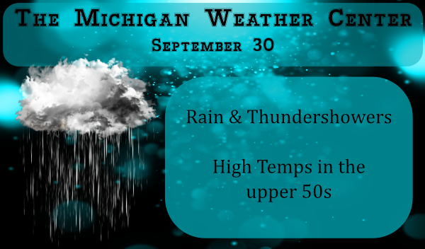
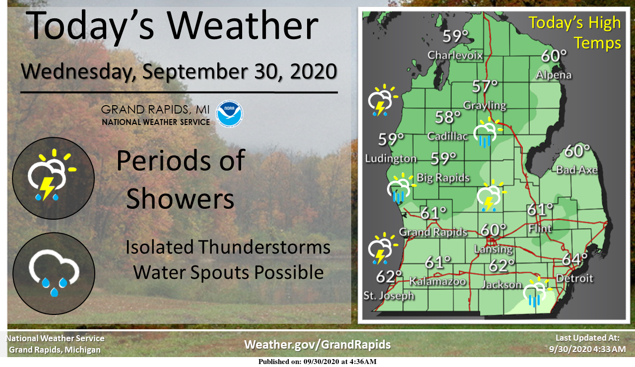
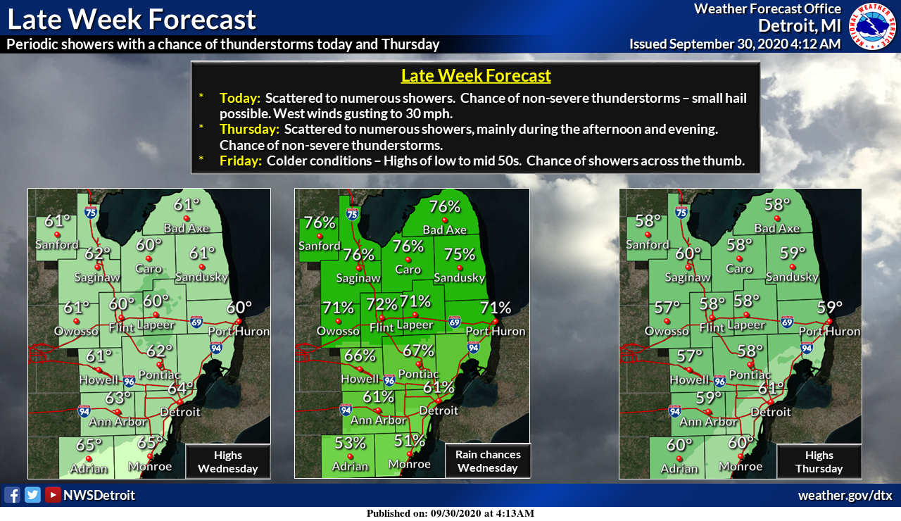
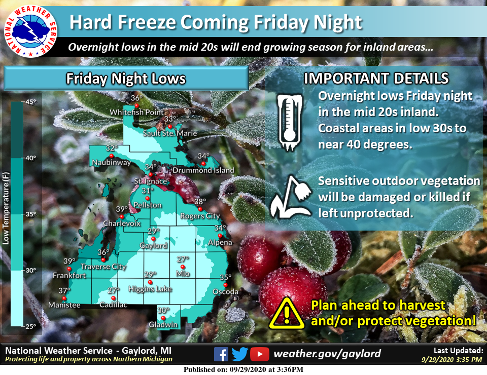
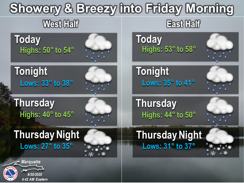
As we close out September periods of showers, isolated thunderstorms, and water spouts are expected into Thursday. Then a cold front comes through and breaks up the clouds by Thursday evening. That will allow for frosty mornings both Friday morning and Saturday morning. Areas north and east of Grand Rapids may have a freeze Saturday morning.
We have a temp of 50° at 5:30 this morning and .13 of an inch of rain overnight in Otsego. This gives us 3.17 inches for the month excluding any rain which may fall the rest of the day.
Forecast
[columns] [span6]
SW
[/span6][span6]
SE
[/span6][/columns]
[columns] [span6]
North
[/span6][span6]
U.P.
[/span6][/columns]
Weather History
September 27
1942: Snowflakes fly across Lower Michigan as temperatures fall to the lower 30s and only rise into the 40s during the day.
2009: A microburst with winds up to 70 mph struck just northeast of Greenville in Montcalm County. About a dozen trees were downed and a travel trailer was tipped over.
September 28
1991: A record freeze hits western Michigan. Grand Rapids falls to 27 degrees, setting record lows for the date and month. Muskegon also hits 27 degrees, setting a record for that date and tying the monthly low. Lansing plunges to 22 degrees, tying the record low for the date set in 1893.
September 29
1953: Temperatures soared to the 90s across western Michigan. Grand Rapids hit 93 degrees and Muskegon 92 degrees, both record highs and records for the latest date of a 90 degree reading.
1967: Wet snowflakes fell at Grand Rapids and Lansing. The high of 42 degrees at Lansing is the coldest high temperature for the month of September.
1986: A severe weather outbreak produces high winds, large hail and two tornadoes across Lower Michigan. One person was injured in Van Buren County as a tornado hit near Mattawan. Six houses were destroyed by a tornado near Rankin in Genesee County.
2006: Several waterspouts were observed on Lake Michigan. One was about 5 miles offshore of Holland, while another was sighted just offshore of Saugatuck. This waterspout approached the coast and may have come onshore, but no damage was noted.
September 30
1899: September ended on a very cool note with a record low of 21 degrees at Lansing and afternoon highs only in the 40s. The high of 44 degrees at Muskegon made for the coldest September maximum temperature on record there.
October 1
1897: Temperatures reach record highs with both Lansing and Grand Rapids hitting 89 degrees. It is the highest temperature ever recorded in October at Grand Rapids.
1974: Cloudy and cold weather prevails with high temperatures in the 40s and snowflakes observed at Muskegon.
October 2
1880: A tornado cut a 15 mile long path of destruction from southern Barry and Eaton Counties into northern Calhoun County. Two children were killed and several other people injured near Bellevue, when the tornado picked up a house and carried it 200 feet before it disintegrated. The roar of the tornado could be heard six miles away.
October 3
1898: Lansing hits 90 degrees for its highest October temperature.
1954: Heavy rains cause some minor flooding across southwest Lower Michigan. Grand Rapids and Muskegon both have their wettest October days on record with rainfall totals around 3.5 inches.
1974: Temperatures plummet into the 20s as very cold weather continues. Record lows include 22 degrees at Lansing, 23 at Grand Rapids, and 25 at Muskegon.
Forecast Discussion
-- Scattered showers and some thunderstorms through Thursday --

Shortwave trough / cyclonic vorticity max at 500 mb propagates
overhead this afternoon, amidst a broader synoptic trough/upper
low over central Ontario. Associated cooler 850-500 mb
temperatures during diurnal surface heating will support
increasingly robust scattered convection, potentially reaching
over 20,000 feet, which is expected to be about -30 C, and MLCAPE
around 500 J/kg. Given the modeled soundings, lightning and small
hail appear possible. It will already be a pretty breezy afternoon
even without convection, with 25-30 mph winds in the mixing layer
below 5,000 feet available to mix down as gusts.

Coverage of showers/storms will decrease as the surface cools
this evening, but occasional isolated showers or storms could
still develop overnight into Thursday, as the core of cold 500 mb
air moves in and moist air with steep lapse rates between 925-850
mb also continues to stream in. With cooler near-surface air also
on Thursday, showers/storms will become increasingly supported by
Lake Michigan, which currently has surface water temperatures
largely between 15 and 18 C.

-- Frost or freeze potential Thu night and Fri night --

Thursday night has that look of winter-style NNW-flow lake effect
(rain this time) west of US-131 and subsidence/clearing over mid-
southern parts of the state. With even colder air still advecting
in, should be a pretty chilly and perhaps frosty night in inland
locations. Friday night looks to be the coldest night, as the
surface winds will be calmer in the midst of the surface high,
though the cold could be partially mitigated by some mid and high
clouds.

-- Rain likely Sunday --

The persistence of the western North American ridge and the
Hudson Bay / Great Lakes trough, and another shortwave and jet
streak digging into the central CONUS between the two, may lead to
cyclogenesis over our region on Sunday. There is majority
European ensemble support for rain on Sunday as a result.
A couple of rumbles of thunder and several rounds of heavy downpours. Cool this week and then back into the 60s and 70s next week.
I was out for my walk and lo and behold what did I hear? Yes, the sound of thunder. At this time I am getting light rain with that thunder with a current temperature of 62.
Slim
Same in Ada 😉
Added 0.07″ of rain here in some showers overnight. At this time it is cloudy and 52.
Slim
Currently 49* degrees out a thee YARDofBRICKS NE of GR damp outside our furnace kicked on overnight so here we go how many consecutive months will it be this time around last year a whopping 8 months in a row crazzy glad I’m ahead with 3 filters as of now. …Have a beautiful Fall Wednesday the weather doesn’t get any better then this lady and gentlemen …INDY
Yesterday was a whopping 1 degree below average. Boy, this is some “cold” weather LOL
CPC is now red!
Ha! Yes, “November cold in September” was mentioned yesterday. Not even close.