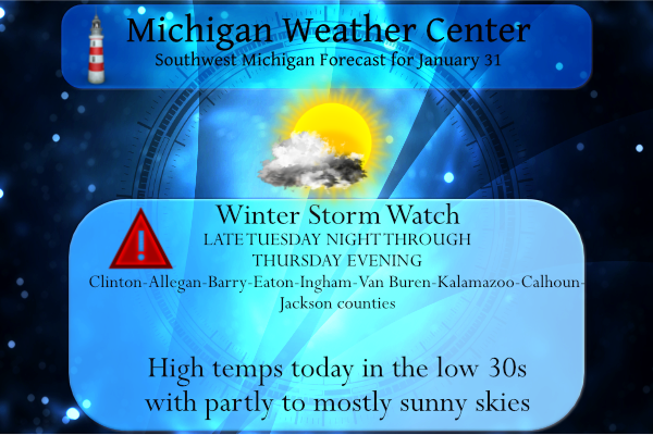
 Well, here we go. The NWS has released Winter Storm Watches for southern Michigan for Tuesday night through Thursday. I am sure counties will be added or deleted before the actual event but we are given plenty of time to prepare. This just goes to show how computer models can change from one run to the next.
Heavy snowfall looks increasingly likely for much of southern Lower Michigan from Tue night into Thu evening. Since the previous update, snowfall amounts have been expanded northward, with the heaviest snowfall still likeliest along/south of the I-94 corridor.
We are closing out the month of January with 17.9 inches of snow. Our last snowfall was on the 26th. We have 31 inches for the season thus far and only need another 9 to surpass last year’s total.
Yesterday’s temp rose to 28° and the low was 8°. Today will be the calm before (the possible) storm with a lot of sun and temps rising towards freezing. Rain will pull in tomorrow starting with some drizzle before turning to snow tomorrow night. We may see temps rising to the low 40s tomorrow.
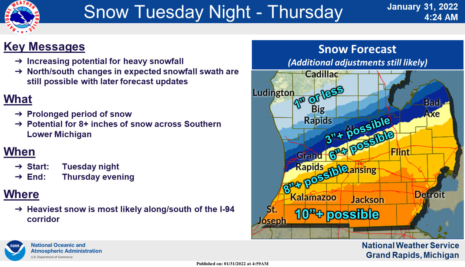
Possible snowfall totals
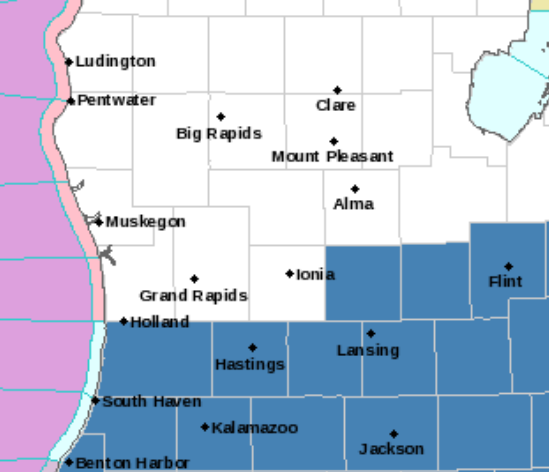
Possible storm path
Forecast Discussion
- Mainly dry through Tue morning

The discussion period begins with fairly quiet weather. A cyclone
emerging across southern Alberta this morning will slide quickly
eastward, reaching northern Ontario by 18z Tue. For our area,
southerly flow will strengthen today/tonight, with corresponding
low-level warm advection. A few flurries are possible today near
the lakeshore, but expect otherwise dry conditions.

Meanwhile, important changes in the large-scale flow will be
underway over the NE Pacific / W North America. Spurred by the
arrival of a Rossby wave packet (and the associated process of
downstream development), upper-level ridge amplification will
occur over the NE Pacific (near 150W) today, followed by
development/amplification of a western North America trough on
Tue. In conjunction with this wave amplification, an upper-level
jet streak will nose into the Pac NW tonight and Tue.

- Lingering uncertainty for midweek system

By Tue evening, an extensive and tightening baroclinic zone will be
established over the central CONUS, oriented SW to NE. Four broad
features in the SLP field will contribute to frontogenetical low-
level flow: the aforementioned Ontario cyclone, an advancing
arctic anticyclone, a SE CONUS ridge, and falling pressures over
the southern Rockies preceding cyclogenesis. South of this
baroclinic zone, an reservoir of anomalously high PW will become
established as Gulf moisture is transported northward and deepens.

A long period of precipitation for much of the southern MI is
expected to begin Tue afternoon. Precip will be sustained, in
large part, by a persistent frontal circulation, as revealed by
low/midlevel Q-vectors directed toward warmer air (geostrophic
frontogenesis) and the accompanying Q-vector convergence-
divergence couplet straddling the frontal zone. Aloft, a coupled
upper jet structure is expected to be present overhead for Wed
afternoon/evening. Thereafter, the right-entrance region of an
anticyclonically curved upper-jet will be overhead through early
Thu night. These features notwithstanding, we note (within the
deterministic GFS) that the closed low-level circulation (frontal
wave) that develops on Thu is rather shallow, extending no higher
than ~850 mb, with an open-wave height configuration at 700 mb and
above.

Total precip continues to be uncertain, largely stemming from positional
uncertainty as to the ultimate track of the frontal wave. GEFS
SLP spread is maximized to the northwest of the ensemble-mean low,
a manifestation of positional uncertainty (NW vs. SE) of the
front and the associated baroclinic zone. Among several of the
global deterministic solutions, the GFS and ECMWF produce similar
total QPF over lower Michigan, with the GEM/CMC being persistently
drier.

Precipitation type will likely begin as rain or a rain/snow mix on
Tue, then transition to all snow Tue night and beyond. A brief
period of freezing is possible for our far northern CWA on Tue
evening, but no appreciable ice accumulation is expected.

BUFKIT time-height GFS overviews at JXN for much of the event
suggest a somewhat shallow (3-4 kft) DGZ atop a very deep near-
isothermal layer. This underlying layer contains considerable
depth with temps > -10C, suggesting that riming may be a factor,
and would function to reduce SLR. Moreover, a persistent
vertical-motion maximum within the DGZ is not readily apparent.
These microphysical considerations will certainly need to be
reevaluated in subsequent model runs.

After coordination with WPC, IWX, and DTX, we will issue a Winter
Storm Watch for portions of our CWA (southern two tiers, along
with Clinton Co).

- Mainly quiet Fri into Sun

The period ends with reinforcing arctic air in the wake of the
departing system, but no appreciable additional precipitation is
expected through Sun.
Megaflash lightning? Never heard of it until now.
https://www.cnn.com/2022/01/31/weather/lightning-megaflash-record/index.html
Wow! That is just ridiculous! A 477 mile long bolt of lightning?? ⚡️
.DISCUSSION…(This evening through next Monday) Issued at 349 PM EST Mon Jan 31 2022 – One more quiet night weatherwise A storm is tracking well north of Michigan overnight. There is a coupled jet feature with that storm. The jet core is passing over Lake Superior so we will be deep into the warm sector of this system tonight into Tuesday. Being currently in the right exit region of that jet feature (mid level subsidence) I do not expect any precipitation or even that much cloud cover. It will turn breezy through. The mixing from the systems boundary layer winds… Read more »
Here’s the latest 5 day GFS snow map and it is horrendous for GR! Total bust!
https://www.instantweathermaps.com/GFS-php/conussfc.php?run=2022013118&time=PER&var=ASNOWI&hour=120
I think it’s going to be close call here. I could see us getting 8″ or maybe just one or two.
You are in a much better spot then GR. The storm for GR will end being one of the biggest busts of the season!
The West Michigan weather dome strikes again. Always storms to the North, or to the South. We just get cold and maybe if we are lucky some lake effect. The weather dome of West Michigan never fails.
You got it! This has happened many times over the last few years!
Winter Storm Warning for all the I-94 counties in the GR CWA for 9-16 inches. Other counties are still in a watch due to uncertainty.
That’s a bunch! Looks like there will be a sharp degradation line with some areas getting a couple of inches and then a foot plus in the adjacent county. This will be fun. FINALLY a storm to track. 😁
Yes even a slight 10-20 mile jog in the track can make a huge difference at someone’s house. Model runs from this evening through tomorrow will be the most crucial.
I have been tracking this storm for 3 days now pretty cool how constantly the models are the so many modles its pretty interesting…The Canadian modle actually gives GR 10+ inches of snow the GFS model comes out in 30 minutes the GFS has been trending south on its last to modles…Also I have talking to a few meteorologist around the area especially eastern Michigan they said they are not jumping the gun just yet on any warnings until tomorrow from there NWS…InDY
One of our local TV mets mentioned this storm a week ago on the air – the same day you and Rocky mentioned it here. It’s rare that they do that so far in advance.
“This is a southeast third of Lower Michigan snowstorm. This isn’t a northern Michigan snowstorm. This isn’t even a central Lower Michigan or Grand Rapids snowstorm.” Mark T
The Euro modle just was released and its showing a more nothern track giving GR 5 to 7 inches of snow now things are definitely changing rapidly stay tuned MV’s best …InDY
There is always hope right until the storm is actually upon us, but I will be very surprised if this one tracks North! Don’t get me wrong, I hope it tracks North, however it is not looking that way to me? I will say the EURO tracking to the North is a good sign!
The next NWS adventure comes out at 4pm should be interesting who goes over to a Winter storm warning and who gets put under Winter weather advisorys definitely GR will be in something im thinking….InDY
Mark Torregrossa’s take:
https://www.mlive.com/weather/2022/01/snowstorm-coming-what-we-know-and-dont-know.html
10:25 forecast discussion update: .UPDATE… Issued at 1025 AM EST Mon Jan 31 2022 The low clouds are being slow to leave our area. We are waiting for the polar jet axis to get east of this area so we will be on the anticyclonic side of the polar jet. Typically, that is when the low clouds start to break up and I am thinking today will be no different. Expect the clouds to clear from south to north during the mid to late afternoon. The models continue to show run to run changes in the snowfall event Wednesday into… Read more »
Yes, South is the four letter word today!
Heavy snow for GR is looking very unlikely! Get prepared for a swing and a miss! Possible 1 to 2 inches?
I am not feeling this storm! Currently I don’t see a trend North, in fact I see a trend south? Hopefully that changes soon! Bring it on!
Just barely out of the Winter Storm Watch where I am. Interesting to note Ionia County never got a winter storm watch OR warning last year. If we don’t with this event we could make a run a 2 years without it which would be pretty remarkable. The most crucial model runs will come through today into tomorrow morning. We shall see how things play out. I’d love a big storm but something tells me it will for areas especially Calhoun county east to Detroit. Would be nice to finally get a significant storm because in the past 2 years… Read more »
Sure would be nice to get a decent storm!
Yup it would, but for GR it is not happening with this one!
Given the fact we are still 48+ hours out, I would not be surprised to see small shifts in the track. Currently looks like 1-94 south will get hit hardest, but a shift of 50-100 miles north or south could bring the snow up to GR or south of the border… I’ll feel more comfortable tomorrow morning on the track, but at this time clearly 1-94 south is in the main impact zone based on the model runs.
The GFS has been shifting south then north on its model runs sure will be interesting to watch the next 36 hours of runs I definitely can see a more nothern run with storm.. The NAM has GR getting 9 10 inches of snow pretty consistent so yes stay tuned …As of now 3 to 6 inches of new snow for the Grand Rapids area is a berry good bet ….InDY
BREAKING NEWS >>>>> Going on 40 days straight with snow on the ground in west Michigan why not some more SNOW?? and even better news for the 40th time NO warm air in sight right?? INCREDIBLE…InDY
>>>>Breaking>>>the latest CVS model hammers us with snow! Stay tuned!
Wow, watches up everywhere except for West Michigan. Another one misses us for the most part!
Lol in your dreams!
Nope, I don’t really want a Winter Storm Watch. But I’m sure you do LOL
With some clearing here at my house the low dropped down to 14 but with the clouds back in it is now up to 19. There was just a trace of snow fall yesterday. The snow on the ground here is now down to 5.5″ It still looks like the bulk of the snow fall with this incoming system will stay to the SE of Grand Rapids and I look to have even less than the airport at this time.
Slim
The Weather channel and acculess weather both give GR a whopping 2-4 inches of snow!
9 vs 9 in the superbowl should be a great game I would not count out Cincinnati they play very smart football seems like Rams live on the edge a little to much but in the end let the best team win …Bye the looks of it Matt Staffords wife looked more happy then Matt did last night shes a hoot lol..We definitely have a major Winter storm coming this storm means business im looking for a 25 or 30 mile storm track shift to the northeast putting GR in the sweet spot For 12+ inches of snow mark it… Read more »
It is marked down!!
A few clouds can make a big difference. Case in point: it is 8 degrees here, but 22 on the other side of town at the airport.
Blake Harms and the other local TV met this morning wisely did not give a prediction of the snowfall amount for the upcoming storm. This may be the biggest storm of the season for our area. As Slim would say, we shall see…
On a side note Congrats to former Detroit Lions quarterback Matthew Stafford, in his first season with Los Angeles, is heading to his first Superbowl, I think he deserves it after frustrating seasons with the Lions.
No doubt and get out of Detroit your chances of winning football games goes up dramatically!
Oh yeah, he’s earned that. I was happy for him to be able to go play for a contender. He gave 100% for 12 years for the Lions – not to mention he and his wife Kelly did a lot of charity work for the Motor City. He’s a good guy and I hope the Rams win the SB.
I have no respect for his wife Kelly, based on some of her idiotic comments last year!
Bring that heavy band up about 50 to 100 miles North! Stay tuned!