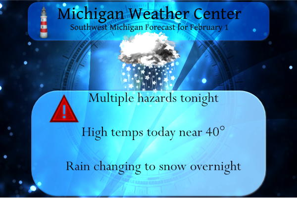
It took a while but we did have the sky party clear yesterday late afternoon. Our high temp was 32° and the low was 23°. Rain should move in late this afternoon turning to snow after midnight.
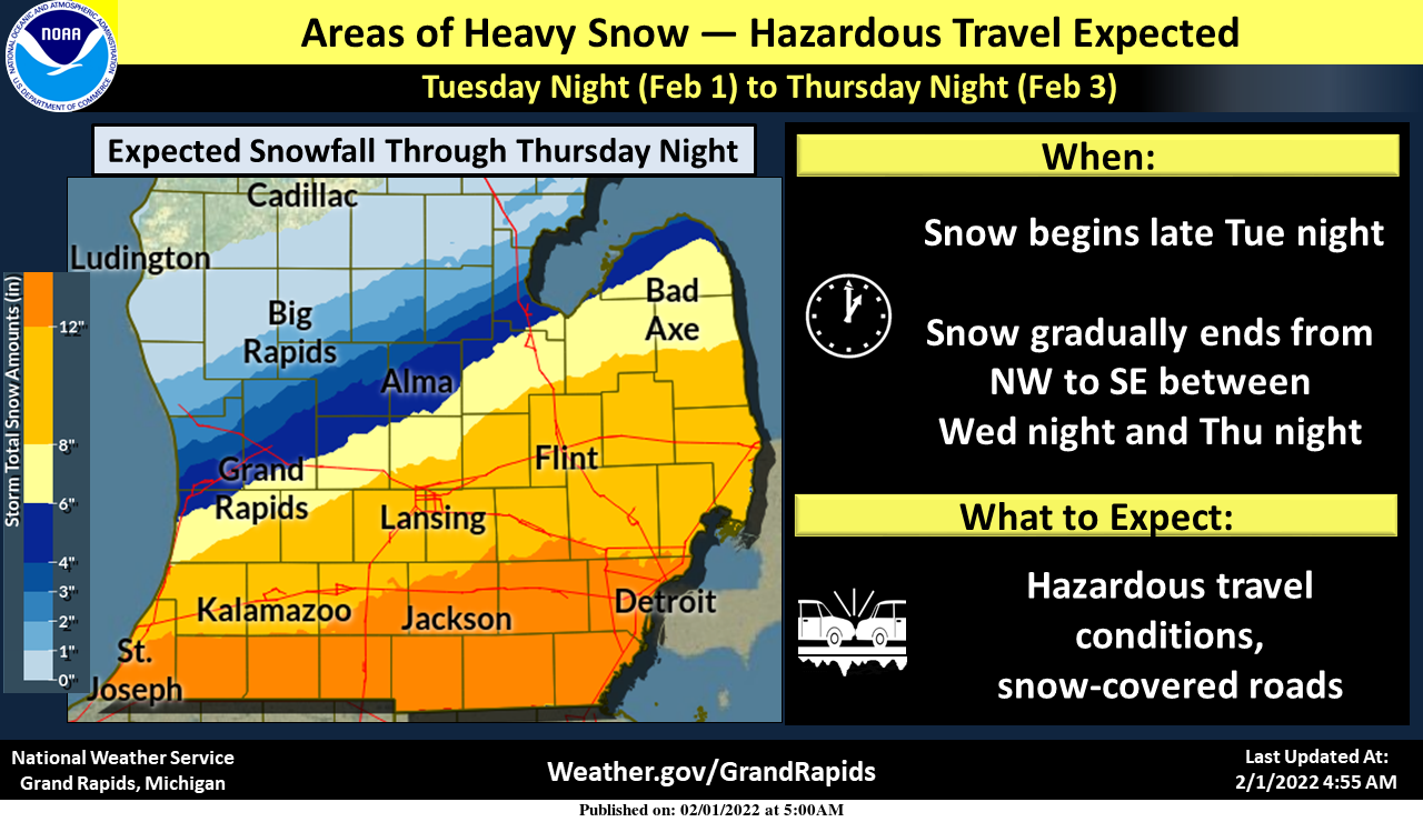
Portions of southern Lower Michigan will see heavy snowfall through Thu. Heaviest snowfall is still expected generally along the I-94 corridor, with amounts tapering off toward the northwest. Travel will be difficult in much of southern Lower Michigan on Wed and Thu.
As the anticipated winter storm approaches southern Michigan we have multiple hazards in place for tonight through Thursday. Snow accumulations of 3 to 6 inches are expected from Grand Rapids to Lansing with 8 to 12 inches possible along southern Lower Michigan from Kalamazoo to Jackson. Another surge of Arctic air will follow for the end of the week. This storm will stretch from Texas, Oklahoma, and Kansas all the way to New York and Vermont.
Current Watches, Warnings, and Advisories (as of 5 am):
...WINTER STORM WARNING IN EFFECT FROM 2 AM WEDNESDAY TO 11 PM
EST THURSDAY...

* WHAT...Heavy snow expected. Total snow accumulations of 6 to 10
  inches.

* WHERE...Eaton and Ingham counties.

* WHEN...From 2 AM Wednesday to 11 PM EST Thursday.
Gratiot-Ottawa-Kent-Ionia-Clinton-Allegan-Barry-
Including the cities of Alma, Grand Haven, Jenison, Grand Rapids,
Ionia, St. Johns, Holland, and Hastings
323 AM EST Tue Feb 1 2022

...WINTER WEATHER ADVISORY REMAINS IN EFFECT FROM 2 AM WEDNESDAY
TO 11 PM EST THURSDAY...

* WHAT...Snow expected. Total snow accumulations of 3 to 6
  inches.

* WHERE...Portions of central, south central and southwest
  Michigan.

* WHEN...From 2 AM Wednesday to 11 PM EST Thursday.
Sanilac-Shiawassee-Genesee-Lapeer-St. Clair-Livingston-Oakland-
Macomb-Washtenaw-Wayne-Lenawee-Monroe-
Including the cities of Sandusky, Owosso, Flint, Lapeer,
Port Huron, Howell, Pontiac, Warren, Ann Arbor, Detroit, Adrian,
and Monroe
351 AM EST Tue Feb 1 2022

...WINTER STORM WATCH REMAINS IN EFFECT FROM LATE TONIGHT THROUGH
THURSDAY EVENING...

* WHAT...Heavy snow possible. Total snow accumulations of 8 to 14
  inches possible.

* WHERE...Portions of southeast Michigan.

* WHEN...From late tonight through Thursday evening.
There is still plenty of time for these to change as we go through the day so stay tuned.
Forecast Discussion
- Quiet weather initially

Banded precipitation returns on regional radar mosaic are quickly
departing eastward as of this writing. These returns are
associated with ongoing low-level warm advection and associated
frontogenesis, but a stout subcloud dry layer has resulted in
virga, with no precip reported at surface.

- Rain begins this afternoon

The main precip event of this forecast period is still expected
to begin as rain this afternoon. Strengthening frontogenesis will
provide deep-layer forcing for ascent along the northern fringe
of a rich moisture plume. The presence of frontogenesis suggests
that precip will likely exhibit mesoscale banded structures.
Additionally, forecast profiles hint that a shallow conditionally
unstable layer (centered near 850 mb) may also be present,
suggesting that precip may exhibit some embedded cellular
(showery) elements as well. Some showers may produce brief graupel
at the surface, but otherwise expect precipitation type as rain at
the outset.

- Rain changes to snow tonight, continues into Thu for southern
  counties

While ensemble spread has fortunately (and expectedly) narrowed,
it is worth noting that positional uncertainty (NW vs SE) of the
frontal zone and lead frontal wave still dominates the overall
spread within the GEFS SLP field. Interestingly, GEFS ensemble
sensitivity analysis (via the Stony Brook Univ / NWS CSTAR page)
suggests that left-of-mean frontal wave tracks will be favored if
higher-than-mean 500-mb heights materialize within the central
CONUS today and tomorrow (and vice versa). These higher 500-mb
heights might arise from latent heating in deep convection across
the Gulf states. The key takeaway is that forecast uncertainty is
still operative at this time, and that this uncertainty stems, in
part, from upstream developments/details that are yet to occur.

Ensemble uncertainty aside for a moment, expect that precip will
largely change to snow by 06z Wed as freezing level quickly falls
amid low-level cold advection. After 06z Wed--and especially
toward daybreak--an uptick in snow rates/coverage is expected as a
coupled upper jet structure develops atop persistent low/midlevel
frontogenesis, providing deep-layer ascent. As noted previously,
low/midlevel Q-vectors are oriented almost perpendicular to
layer-mean isotherms (toward warmer air) for a prolonged period,
with Q-vector convergence (divergence) along the warm (cold) sides
of the frontal zone. This indicates that QG frontogenesis will
act to sustain a deep transverse circulation along the frontal
zone, with this circulation characterized by rearward-sloping
ascent of warm/moist air. The timing of precip cessation will
largely depend on the progression of the frontal zone toward
warmer air with time. This progression, in turn, will be
influenced by the leading frontal wave and its shallow closed
circulation propagating NE along the baroclinic zone on Wed.

With the latest forecast updates on this shift, there is little
change to our storm-total snowfall forecast. Heaviest
accumulations (6-12 inches) are still expected along/S of the
I-94 corridor through Thu, with travel impacts expected. However,
it is worth noting again that a rather pronounced accumulation
gradient (SW to NW) is expected from this event. This gradient is
attributable, in part, to the inherently mesoscale dimension of
the frontal circulation associated with this event. Additionally,
within the northwestern portions of the snowfall area, sublimation
of falling snow will likely be a considerable factor, owing to
the steady infusion of low-level sub-saturated arctic air from the
north. Obviously, even subtle lateral shifts in the positioning
of this gradient will have significant implications for the
geographic snowfall distribution.

- Cold but generally quiet into Mon; some LES possible

Expect generally quiet weather into Mon, but with a few
opportunities for lake-effect snow, mainly on Fri night, and again
on Sun afternoon into Mon. Considerable timing/placement
uncertainty exists regarding the synoptic features that would
modulate LES during these periods, but these details will likely
become clearer in the days ahead.
All schools closed in this area. 1st snow day here in more than 2 years.
We got closings coming in over this way too. There are some here closed Wednesday and for Thursday.
Seems like an early call especially for Thursday?
Wow!
The ones closed for 2 days already are in St. Joseph County
+1
Here is the latest from the GFS!
http://wxcaster.com/gis-gfs-snow-overlays.php?STATIONID=GRR
I mean I won’t complain about a half foot… but the 20 inches would be nice 😀
Yes are just missing a monster snowstorm, but we will take a few inches anyday!
A slight shift north has a impact on totals at my house that’s right on the edge of the lesser and more significant totals. We shall see how things shape out.
Hey Indy, maybe my reverse logic worked yesterday! Keep that baby tracking North! Incredible!
A slight North trend! That is a start! The latest 18z RDB model gives GR 2-4 inches! Keep that trending North baby! Andy and Barry told me he would like at least 6 inches of snow! Incredible!
Lol…grasping again..InDY
Check out all the snow moving in from northwest Illinois this storm is massive and growning as I post what a amazing Winter storm for west Michigan and all of lower Michigan shuuu…InDY
Updated forecast discussion: – Winter Storm Expected Wednesday into early Thursday The winter storm we have been forecasting remains on track. There has been a trend in the large scale models to bring the snowfall farther north over the past 36 hours. We have added Montcalm County to our Advisories, and Barry and Clinton Counties to our warning list. The ensembles of both the GFS and ECMWF have not changed to overall storm QPF significantly over the past 48 hours, looking at the location, the amounts, or the timing. What has become more clear is the second phase of the… Read more »
More countrys going over to winter weather advisory north that means one thing the storm is moving more north could it be GR falls under a Winter storm warning soon stay tuned…Not bad for the winte storm that was supposed to mis us!!! MV!! InDY
The rain that is expanding across the area this evening, will begin to change over to snow from NW to SE after about 10 pm this evening. It will continue to change over through the rest of the area overnight. Then locally moderate to heavy snow at times can be expected on Wednesday, especially closer to the southern border.
Here is the SE Michigan snow guess:
I see 50’s in Lower Michigan! Phew!
Heck yeah!! I am squarely in the less than 2” accumulation region!! FANTASTIC!!
The winter storm we have been forecasting remains on track. There
has been a trend in the large scale models to bring the snowfall
farther north over the past 36 hours. We have added Montcalm
County to our Advisories, and Barry and Clinton Counties to our
warning list.
Yes Slim and MV’s best January was a very cold and snowy month one of the best in years for Winter fun outside you’re own home and even Zealand had above average snowfall amazing facts….Crazzy how this time tomorrow the roads will be snow covered and slippery again Happy Snowruary!! INdY
It has now started raining here with a temperature of 43.
Slim
Starting to sprinkle here as well!!!
Very chilly rain outside Slim as the tenp falls the snow will fly ….InDY
More great news>>>the ground is still frozen solid and in a couple days we will be back in the deep freeze! Keep winter rocking! Incredible?
Winter is dying and NWS GRR says more quiet weather through early next week after the storm. Let the snow deficit grow! I love it!
Its going to take more then one day in the low 40’s to unfreeze the ground around here my favorite fishing hole has 11 inches of ice crazzy …InDY
It seems it is warmer than expected today? Like by 4 degrees. Not sure if this is due to the ridge being displaced further north than expected, which would result in the track perhaps being further north than expected.
Just an observation… I could be wrong but it is definitely warmer than they were expecting. Currently 48, almost 50, most forecasts had us in the low 40s
The forecasted high by the NWS for GR was 41. Significantly warmer right now at 48. I’m sure no one is complaining, but interesting to note
They were off big time! Reminds me of those spring days when we outperform by 5-10 degrees. I love it!
The weather app that came with my phone said 50 for today and I thought, no way. Who knew?
Wow yea, even 40 was questionable to me. It is hard to reach 50 this time of year.
Does anyone have the numbers or know a good source for snowfall records for Central Michigan? Mount pleasant or Alma would be the nearest “cities”. My guess is that North Central Michigan has been hosed this year so far in snow. And although things may change, this storm looks like it is also going to miss us. I drove through Mt Pleasant today and it was 43F and the little snow on the ground is rapidly melting.
At Alma this winter season has reported 17.8″ of total snow fall. Average by the 1st of February is 21.6″ The central part of lower Michigan has some of the lowest average snow falls per season. The old written records I have has the average seasonal snow fall for Alma as 41.8″ and for Mt Pleasant as just 36.3″ I think they do keep records at Central Michigan University if you can find their records.
Slim
Thanks! Exactly the info I was looking for.
It is now up to 47 here with cloudy skies.
Slim
Boy, how many times were we told there was no way we were hitting 40 degrees this week? Currently 48 here, can we hit 50??
We are way to cold for 40’s and rain next week sorry Slim I dont agree with that forecast Im thinking it will change…InDY
January 28, 2022 8:19 am
INDY
INDY
Definitely no 40’s coming next week matter affect we me be feeling our coldest air of the season yet coming I cant wait to see wood tv 8 takes them 40’s out of there forecast and tell us why l
Whoops!
Wow up to 45 here!! Incredible warmth for this time of year!! Bye bye snow pack!!! Keep it ROCKIN!!
Hopefully melting some of the snow off the roofs for tomorrows round…
Great News>>>the warm up lasts about 18 hours and then we have 46 more days of WINTER!!!! I love it!
I see they have added Barry County to the Winter Storm Warning
.UPDATE…
Issued at 1245 PM EST Tue Feb 1 2022
We have added Barry County to our Winter Storm Warning based on
the latest trends in the storm forecast snowfall. Seems Barry
county would get the 6 inches in 8 hours or 8 inches in 18 hours
from this storm tomorrow.
It is interesting Allegan isn’t in it? Is it because it is close to the lake? I mean for those of us closer to Kazoo and Barry counties…we may be on the “border” so to speak???
There will NOT be any lake effect for this part of the system on this side of the state.
Slim
I was thinking that… but just curious why they leave Allegan out of the warning area?
It is my thinking the extreme SE corner of the county will see more snow as the storm is moving to the NE.
I was thinking the same… so are you thinking your area Michael?
yup, but who knows, it is all a crapshoot no matter how you look at it 🙂
Up to 41 degrees already today!! Got some fantastic melting going on out there! Let’s keep that snow deficit going!
46 here. Just took the dog for a walk. It’s so nice outside.
Beautiful and Spring is just around the corner!
https://days.to/until/spring
We have 48 with sunny skies! I think tomorrow will be a shock after spoiling us today
With January 2022 now in the books lets take a look and see how it turned out. At Grand Rapids the mean was 20.4 that is a departure of -4.6. It was the coldest January since 2014. The high for the month was 42 on the 19th and the low was -2 on the 26th There was a total of 25.8 of snow fall and the total precipitation for the month was 1.43” The most snow on one day was 8.0” on the 5th and the biggest snow event was 12.6” on the 5th and 6th the most snow on… Read more »
Up to 34 degrees already. Let it melt! Hope we can get some thunderstorms!
A walk down memory lane. Anyone remember this broadcast? This was the broadcast at 12pm 11 years ago today. A monster blizzard was bearing down on West Michigan. It’s a storm I’ll never forget. I got about 18” of snow at my house. I remember we were snowed in for a while. My dad got his truck stuck in a huge snow drift near 16th street and 146th Avenue in northern Allegan County. Luckily he had a snowblower and shovel in the back, fired it up and and got himself out. A storm I’ll never forget.
https://m.youtube.com/watch?v=wWND9UTdi8c
Sheesh I don’t remember last month, let alone 11 years ago. 🙂
Great find. That was fun to watch.
My most memorable one was the 1978 blizzard, Slim & I were both around for this one. No one was out driving because all the roads were closed. 131 had drifts of 19 feet in some locations – this was one you sheltered in place.
My dad was in college back in 1978. I was not around for long after… but I do remember the 2011 blizzard.
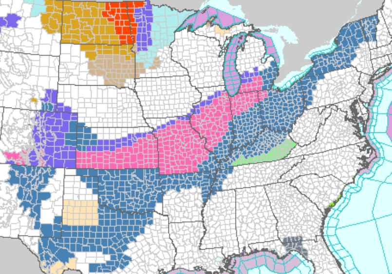
This storm is a monster. There are watches and warnings from New Mexico to New Hampshire.
The scope of the weather alerts reminds me of what the weather alert map looked like for the Groundhog Day storm 2011 (without the blizzard warnings and a little further south of course).
It’s odd seeing winter storm warnings in the southwest and yet only a winter weather advisory for GR. It seems like everyone has been getting huge snowstorms this year – except much of Michigan.
If you have problems deciphering the area forecast discussions we do have an NWS glossary page to help you out: https://michigan-weather-center.org/nws-glossary For example, the terminology for ‘area forecast discussion’ follows: This National Weather Service product is intended to provide a well-reasoned discussion of the meteorological thinking which went into the preparation of the Zone Forecast Product. The forecaster will try to focus on the most particular challenges of the forecast. The text will be written in plain language or in proper contractions. At the end of the discussion, there will be a list of all advisories, non-convective watches, and non-convective… Read more »
I’m thinking I can squeeze out a solid 4-6” at my house. We shall see. Mostly cloudy right now with thw wind is blowing snow on the road here already.
Mark mentioned this yesterday:
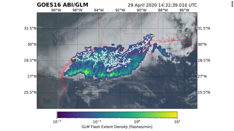
The new record for longest single flash covered a horizontal distance of approximately 477 miles (768 kilometers) from Texas to Louisiana April 29, 2020. The impressive distance is comparable to the stretch between New York City and Columbus Ohio, said Cerveny. It bypassed the previous record by 60 kilometers.
Winter Weather advisory for GR whats another 6+ inches of snow just in time for February…Let it snow let it snow let it snow..InDY
Keep up the positive thoughts and we need a slight shift to the North! Northern IN will be getting pounded with snow!
Breaking>>>>>despite the constant warm weather hype – January ended up well below in temps and above in Snowfall! How could it be! With one more snowstorm we will be above for the season! Great winter despite a couple big storms just missing us! Incredible!
Wow, 40 degrees and thunderstorms with another big snow missing us. I love it!
Lol…Yes a total miss!! InDY!!
Very detailed forecast discussion, however for GR get ready for a dud of a storm! Very disappointing set up! The preliminary RDB gives GR a whopping 1 or 3 inches! Better than nothing but a big miss on another big storm!