A quiet weather and a slow warming trend will occur over the next several days. The warmest air will surge into the area on Sunday and Monday ahead of an approaching low pressure system. This system will provide widespread rain and windy conditions from late Sunday through Monday. A strong cold front will push through the area late on Monday, bringing falling temperatures and snow showers behind the front Monday night and Tuesday.
No significant weather in the near term as temperatures continue to moderate in general warm advection pattern from the south. Expect precipitation to hold off through Saturday afternoon but clouds should be on the increase as moisture streams up from the south in advance of low tracking west of Lower Michigan.
Temperatures will return to near to perhaps even slightly below normal by the middle of next week as cold air advection occurs on the back side of that departing system. We also expect some snow showers Tuesday with decent wrap around moisture on the back side of the system. An upper level system may bring more snow showers for midweek although a sfc high pressure ridge will mitigate the snow shower potential by Wednesday considerably.
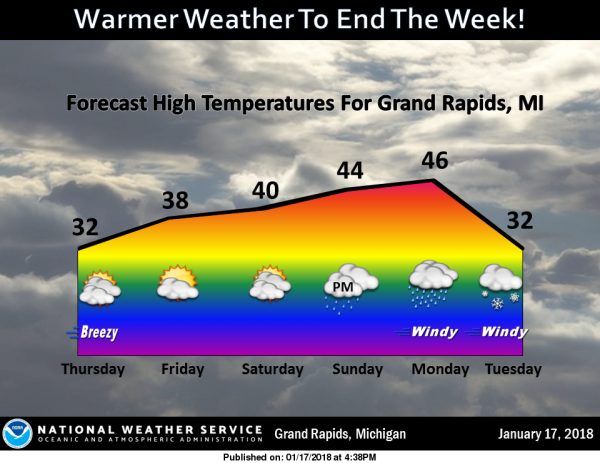
Today: Mostly sunny, with a high near 30. West southwest wind 15 to 17 mph.
Tonight: Mostly clear, with a low around 21. Southwest wind 13 to 15 mph.
Friday: Mostly sunny, with a high near 36. Southwest wind 10 to 14 mph.
Friday Night: Partly cloudy, with a low around 30. Southwest wind 14 to 16 mph.
Saturday: Partly sunny, with a high near 39. Southwest wind 10 to 13 mph.
Saturday Night: A 20 percent chance of snow showers after 1am. Mostly cloudy, with a low around 32.
Sunday: A chance of rain and snow showers before 1pm, then a chance of rain showers. Cloudy, with a high near 44. Chance of precipitation is 50%.
Sunday Night: Showers likely, mainly after 1am. Patchy fog. Otherwise, cloudy, with a low around 38.
Monday: Showers likely. Patchy fog. Otherwise, cloudy, with a high near 46.
Monday Night: Rain and snow showers likely before 1am, then a chance of snow showers. Mostly cloudy, with a low around 28.
Tuesday: Snow showers likely. Cloudy, with a high near 31.
Tuesday Night: A chance of snow showers. Mostly cloudy, with a low around 21.
Wednesday: Partly sunny, with a high near 30.
FRYDAY!!!!!! TUNE…..
https://m.youtube.com/watch?v=JPxN6zcLtPQ#
The Euro now has 47 degrees for Monday for GR. Then 44 degrees and 51 degrees the following Friday and Saturday! Only two inches of total snowfall for the next 10 days. Dry and mild.
I’m looking forward to several inches of snow coming Monday night into Tuesday hopefully its ton… INDYDOG14!!
It is off to a cold start here in northern Florida the reported temperature is 21° here. Looking out the window the sky is clear but there is no frost on the cars so either its very dry out or the wind held up. Today we are visiting family in Tallahassee and then off to far SE Florida where It will be cool but much warmer then it has been so far. I want to wash off my SUV today as it is covered in road salt and I can hardly see out the back window as the wiper has… Read more »
This is from last night We are in Marianna Florida. The trip from Bowling Green took longer than normal. There were some heavy snow showers in Tennessee. So that was kind of a slow go there was snow on the ground to just north of Birmingham. I thought we were thru all of the snow BUT south of Birmingham there were trucks going north with snow on them, Lots of snow. And then there was a convoy of snow plows (yes snow plows) and I knew that was not real good. Well before we got to Montgomery there was a… Read more »