I know that there has been talk of the heat this past week or more but the truth is this past weeks heat and humidity are no comparison to the heat of 2012 or 1936. It very well may not have been nearly as humid in 2012 and 1936 as both happened during a very dry period but there is no comparison to the amount and length of the amount of heat. In 2012 starting on July 1st the highs in Grand Rapids were 91 on the 1st 96 on the 2nd and 3rd 99 on the 4th 101 on the 5th the hottest day 104 was on the 6th and a official reading of 99 was on the 7th here at my house I had highs of over 100 on the 4th 5th 6 and 7th while the “official” high was 104 I reached a whopping 108 here at my house If that had happened at GRR that would have tied the all time record for Grand Rapids.
Here in Michigan the hottest longest stretch started on July 7th 1936 and lasted until July 18th The heat started off to our west in June, however here in Michigan June 1936 was in some locations much cooler than average. In fact at Muskegon June 1936 set the record for the coldest June on record there with a mean of only 57.2° (-9.1°) the warmest for the whole month was only 78° and on June 20th 1936 the temperature fell to 35° At Lansing June 1936 was -3.4° and here in Grand Rapids it was -1.2° elsewhere around the state Detroit, Saginaw, Alpena, Houghton Lake, and the Sault were all below average.
Now for the Great Heat Wave. It started on July 7th 1936 here in Grand Rapids with a high of 98° Here are the high/lows for the next 11 days. The 8th 101/78, the 9th 101/78, the 10th 102/78, the 11th 99/78, the 12th 106/74, the 13th 108/79, the 14th 102/74, the 15th 86/69, the 16th 94/65, the 17th 93/67 and the 18th 91/69. In Lansing the “heat” was not as extreme there the high/low during the above dates were. 91/56, 98/70, 96/70, 98/71, 96/72, 99/71, 99/74, 101/69, 84/60, 86/59, 88/61 and 88/64. Now while it was hot in both GR and Lansing for any who could get over there at the lake shore it was much cooler and on some dates it was not hot at all. Here are the readings for Muskegon for the dates between July 7th 1936 and July 18th 1936. Starting out on July 7th 89/67, 80/65, 82/69, 78/70, 82/73, 82/71, 88/71, 86/70, 86/70, 85/69, 81/68, 78/66 and 79/66. Muskegon was one of the few locations that did not reach 100 or better in the 1936 heat wave. In other locations around the state here is a list of the high temperatures for the dates July 7th to the 18th Detroit 89,104,102,102,101,100,102,104,87,90,89,89. Flint 94,108,105,102,104,105,108,105,91,91,91,92. Saginaw 98,107,104,107,107,105,111,92,95,96,87. It was not any cooler in norther Michigan as here are the readings from Alpena starting on July 7th 100,104,100,105,106,91,87,85,86,81. After a low of 35° on July 1st at Houghton Lake the highs starting on the 7th 100,107,105,106,105,104,107,101,91,92,91,87. At the Sault like Muskegon it was cooler than other locations and also like Muskegon the Sault was one of the few locations that did not reach 100 or better. At the Sault the highs were 93,95,96,93,95,96,89,87,81,83,83,78.
Here are some of the records that were set in 1936
July 5, 1936
South Dakota state record, 120 at Gann Valley
July 6
Minnesota state record, 114 at Moorhead
North Dakota state record, 121 at Steele
Bismarck, ND 114
Fargo, ND 114
Aberdeen, SD 115
July 7
Traverse City, MI 105
July 8
Toronto, Ont. Canada 105
Flint, MI 108
July 9
New York City (Central Park) 106
Syracuse, NY 102
Rochester, NY 102
Scranton, PA 103
Williamsport, PA 106
Youngstown, OH 103
Toronto 105 tied record
July 10
Maryland state record, 109 at Cumberland and Frederick
New Jersey state record, 110 at Runyon
Pennsylvania state record, 111 at Phoenixville
West Virginia state record, 112 at Martinsburg
Baltimore 107
Lynchburg, VA 106
Lexington, KY 108
Toronto 105 (three days in a row!!)
July 11
Manitoba provincial record, 112 at Treesbank
Brandon, Man. Canada 110
Winnipeg, Man. 108
Norway House, Man. 101
Minot, ND 109
July 12
Manitoba provincial record tied, 112 at Emerson
Kapuskasing, Ont. Canada 101
Grand Forks, ND 109
July 13
Michigan state record, 112 at Mio
Wisconsin state record, 114 at Wisconsin Dells
Ontario provincial record, 108 at Atikokan and Fort Frances
Duluth, MN 106 (Wow!!)
Eau Claire, WI 111
Green Bay, WI 104
Waterloo, IA 112
Evansville, IN 108
Grand Rapids, MI 108
Saginaw, MI 111
July 14
Indiana state record, 116 at Collegeville
Terre Haute, IN 110
Toledo, OH 105
Rockford, IL 112
Moline, IL 111
Dubuque, IA 110
Madison, WI 107
Minneapolis, MN 108
Rochester, MN 108
July 15
Peoria, IL 113
Quincy, IL 114
Kirksville, MO 113
Lexington, KY 108 (tied record from 7/10)
July 16
Mobridge, SD 116
July 17
Norfolk, NE 116
July 24
Kansas state record, 121 at Alton and Fredonia
Nebraska state record, 118 at Minden
Grand Island, NE 117
Topeka, KS 114
Slimjim
69* degrees 61* dewpoints out at thee YARDofBRICKS NE GR feels wonderful .. Crazy how a few like it so darn hot on here ..INDY
You could feel the cooler air move in and humidity leave this evening. 🙂
Cold front is here, and so is the wrap-up to Summer in the Southern Arctic. Two weeks of warm weather…expecting more is simply greed. Jackets back on, snow rakes, test fire the snow blower, etc…you know the routine.
🙂
Sounds absolutely awesome!
78* degrees Dewpoints 66* out at thee YARDofBRICKS NE GR …open a window ..INDY!
Temps are dropping outside feels refreshing with a the wind out out of the northeast getting darker earlier now …Love it..INDY!
Sunset at the solstice was 9:25, today it was 9:24. I highly doubt you can tell the 1 minute difference.
https://www.timeanddate.com/sun/usa/grand-rapids?month=7&year=2019
Must be the clouds then lol…INDY!
Interesting coincidence that almost exactly at the Summer solstice the weather pattern has flipped from cool and wet to hot, dry, and humid.
Keep drinking lots of water and use sun screen it is the hottest part of summer …INDY!
Not sure if it is the highest Dew Point ever reported in Grand Rapids but on July 13th 1995 Grand Rapids had a Dew Point of 79° with a air temperature of 96 that would be good for a Heat Index of about 114
Slim
Wow!! So much for it cooling off out there today! Still close to 90 and the heat index still in the 90’s!! The heat wave continues!!
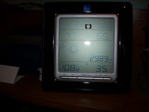
Mookie brought to our attention that a Dew Point of 82° was reported at Marshal’s Brooks airport. I have sent this to the NWS to see if that can be verified and if so if it was indeed a record for Michigan;
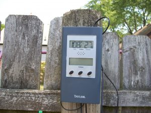
On July 6th 2019 a reported Dew Point of 82° was reported at Marshal’s Brooks Airport can this be verified. If so I believe this would be a record Dew Point for the state of Michigan
Slim
Lake Michigan water temps are now 6-8 degrees warmer than average! And the Great Lakes average water temps will soon be warmer than any of the past 5 years! Wow!
That is an incredible rebound with this stretch of hot weather! We were at the Grand Haven beach last night and the water felt like bath tub water.
Well you keep your house at 60 degrees so bath water may be around 62 degrees for you! I have never felt lake MI feel like bath water! Incredible!
Ask anyone who’s been there this weekend, walking along the edge it felt like bath water, no coolness to it whatsoever. Look at the temp graph below, and those aren’t temps right along the shoreline. Where we were walking it was easily 80 degrees.
Currently an 82 degree dew point in Marshall! All time record high in Michigan??
I see that. I will send a message to the NWS office and see if I get a response on that. unsubstantiated U.S. dew points include 90 at Appleton, Wis., on July 13, 1995; 91 at Melbourne, Fla., on July 12, 1987; and 90 at the New Orleans Naval Air Station on July 30, 1987. Chicago’s highest dew point: 83 degrees on July 30, 1999. Not sure what Michigan’s highest has been If I get a response I will let you know. Also I know a person who lives in Marshal I will text them and see if they can… Read more »
The CPC is now keeping the heat on most of July!
Loving the breeze out of the north today feels refreshing…77* degrees out at thee YARDofBRICKS NE GR at 1115am..Fact is feels a lot better then yesterday already ..INDY..
Nope. Dew point actually went up the past hour, now at a smothering 72.
https://w1.weather.gov/data/obhistory/KGRR.html
More earthquakes in California. Mother Nature is restless.
Barry brought something to my attention about the lack of thunderstorms this year so far. Looking through the daily records for Grand Rapids there was only one day with thunder in June and that was June 1st In May there were 4 days with thunder but only on 2 of the days were thunderstorms reported and so far in July there have been thunderstorms reported on 2 days. So for the months of May, June and the first few days of July there have been 7 days of thunder but only were reports of thunderstorms on 4 of the 7… Read more »
I’m not sure, but it seems like by our place we didn’t have any thunder the wholly month. Rather odd for how much rain we had, and even more odd we had more thunder this past Winter than we had in June.
This 2 weeks of warmth is nothing like last year and why even compare it to July of 2012? Nice write up Slim on that thought I can already feel the dewpoints dropping this morning and with the showers moving in our cooling trend is starting again.. Have a super Saturday MV’S best ….INDY!
You can’t see the future. How would anyone know what’s coming the next 2 or 3 months?
The long range is all just a guess. And as you know even a broken (analog) clock is right twice a day.
Slim
Future? Hmmm hunting season is coming days are getting shorter and the next 10 days seeing no 90*s sounds like facts to me what future? Lol…INDY!
The next 10 days weather that hasn’t happened yet are already facts? Well that makes perfect sense. Kind of like a week or so ago when you posted our only shot at 90 the rest of the Summer was that day. How’d that work out?
Dink! Lots of water keep hydrated .INDY!
Welcome to day 12 of the heat! As always, Slim isn’t impressed unless it makes an all time record lol
Yeah 2012 was hot! Right in the middle of the July heat wave we did our roof and put new siding on our house. It was just terrible working outside, but I had taken that week off from work well in advance so we had to do it. We would start at 8 at night and work till 3 in the morning, but then it was almost worse because there was no breeze. I’d love to know what the dew points were then, but no record of that. This week may be 5 to 10 degrees cooler, but it’s the… Read more »
The Dew Points in 2012 were in the upper 60’s to low 70’s and the temperatures were 8 to 14 degrees warmer in 1936 the temperatures were 10 to 18 degrees warmer so even if the DP’s were lower the heat was much worse and then there was 1988 with the day after day of temperatures in the 90’s and dont forget just last year as well.
Slim
Last year has to be one of the most humid Summers I can remember. This year June was wet, but the temps were lower so not as bad. I just hope the next 2 or 3 months don’t stay as humid as it is now.
1 question, did GR have any thunderstorms for the month of June?
Going thru the daily reports it looks like the only day thunder was reported at Grand Rapids was on June 1st I will keep looking but looks like maybe there were no thunderstorms as such.
Slim
Good find Barry as there have been very few thunderstorms so far this year even with the humidity (well at least the last few days of June and all of the days so far in July have been humid)
Slim