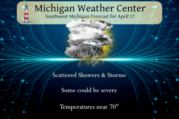
Temperatures pushed up to 76° again yesterday making it three days in a row with temperatures in the 70s. We should make the low 70s once again today before temperatures drop back to near normal for tomorrow and below normal to close out the week.
SPC Forecast
NWS Forecast
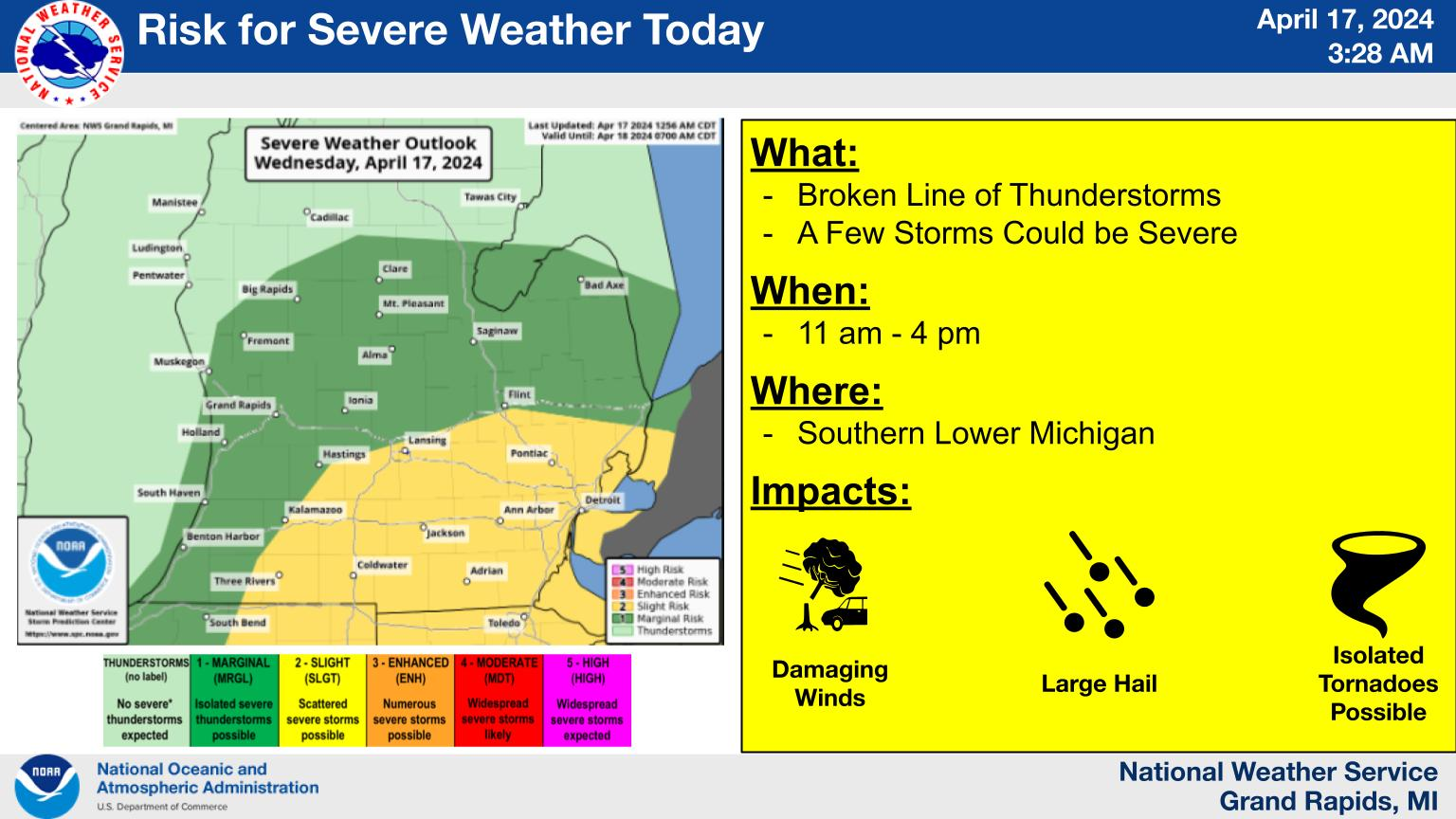
A line of showers and storms will fire over the area by noon today, and move through during the early to mid-afternoon hours. Some of these could become strong to severe. A few additional showers and a storm will be possible on Thursday before the area dries out on Friday. A significant cooldown is forecasted for Friday and through the weekend.
Weather History
1875: Extreme late-season cold sets records across Lower Michigan. Detroit falls to 10 degrees on this date and 8 degrees on the 18th. Lansing bottoms out at an incredible zero degrees.
1922: Heavy rain from a slow-moving thunderstorm causes some street flooding in Grand Rapids. The daily total of 2.94 inches at Grand Rapids is a record for April.
On April 17, 1963, Monroe County was hit hard by an F3 tornado at 6:20 PM that injured 1 person and caused approximately $250,000 in property damage.
1922: Southern Illinois and Western Indiana saw two rounds of severe weather, including tornadoes. The first significant tornado occurred just before midnight on the 16 near Oakdale, Illinois. This tornado killed 4 and injured 22 others. Five additional tornadoes took place between midnight and 3 AM on the 17. During the mid-morning and early afternoon hours, two estimated F4 tornadoes caused devastation in Hedrick and near Orestes in Indiana. A postcard from one farm near Orestes was dropped near Mt. Cory, Ohio, 124 miles away.
1942: West Palm Beach, FL was soaked by 8.35 inches of rain in just two hours.
2002: The heat wave continued across the east as high pressure off the Carolina blocked a frontal boundary across the Plains. Records for the date included:
Newark, New Jersey: 97
NYC Central Park: 96
Hartford, Connecticut: 95
Philadelphia, Pennsylvania: 95
Reagan National Airport, DC: 95 (Tied monthly high)
Lynchburg, Virginia: 94
Atlantic City, New Jersey: 94
Norfolk, Virginia: 93
Providence, Rhode Island: 93
Boston, Massachusetts: 93
Portland, Maine: 80
Forecast Discussion
- Scattered potentially strong storms today

Latest Nam3km seems to have a pretty good handle on current radar
activity, which would suggest two periods of storms today. The
first begins now with the storms over the lake and then another
round by 18z.

Radar shows scattered convection developing from near LDM
southwest across the lake near the warm front. Quite a bit of
lightning occurring over the lake, but storms have generally be
below severe levels to the west. The storms were moving northeast,
which should continue given boundary layer flow. An area of
steeper mid level lapse rates near 7c/km was noted over east
central WI and that area is progd to move northeast toward LDM
withing the next few hours.

HRRR soundings show a pronounced inversion near 900 mb with
limited instability north of the warm front. Thus, we don`t
anticipate the convection to bring down the stronger winds aloft.

This area of convection will move end by 12z leaving several hours
of dry weather, especially across the southern cwa; regional
radar shows a dearth of echos over northern IL/northwest IN at
this time.

Instability will ramp up later this morning, especially over the
southern cwa behind the warm front. HRRR/Nam3km/HREF show another
round of convection developing around noon over the lake. Forecast
soundings shows SBCAPE in the 1500-2000 j/kg range and the
aforementioned models point toward a broken line of storms
developing along the lake shore around 16z and then moving east,
exiting the cwa by late afternoon. Given the strong shear coupled
with the frontal lift and ambient instability, a few of the
storms could be strong to severe with strong winds the main
threat.

Tonight will be mostly dry as the upper trough moves east, but the
next system developing in the mid Missouri Valley will already be
taking aim on the Great Lakes, so cloudy skies are expected
Thursday and an afternoon shower isn`t out of the question as an
upper low noses into the region.

- Period of Rain Thursday Night

As a frontal zone tracks in from the west later Thursday and into
Thursday night a wave develops along it, just south of the CWA. A
southerly low level jet over the OH Valley will advect moisture into
the frontal zone. PWAT`s climb up to around an inch as the front and
associated wave move through. There is even some weak elevated
instability. Ensemble QPF values have been trending up. As a result,
we will increase the POPs, higher QPF and feature a low risk for a
few storms.

- Cooling off for the Weekend

Colder air advects in from the northwest behind the departing front
Friday into Saturday.  Temps at 850 mb lower down to -7 to -9 deg C
on Saturday.  That will likely keep the daytime highs in the 40`s.
Then with a potential for some clearing Saturday night and starting
off the evening only in the 40`s, we will likely see below freezing
temperatures for Sunday morning. The low level thermal trough will
be east of the CWA Sunday so it won`t be quite as cool as Saturday
but still well below normal.  However with a surface high over the
area Sunday night, good radiational cooling is expected.  Thus a
risk for overnight lows to drop down to near freezing  will exist,
especially for inland sites.
No 70’s in sight! Facts, people facts!
Viewer submitted photos and vids from today’s storms. Scroll down to the excellent vid from Erin Sharp in Eaton Rapids – especially if you click and drag the timeline thingy (don’t know the proper term) back and forth. This was cell that warranted the tornado warning. Pretty awesome rotation.
https://www.wlns.com/weather/weatherstories/share-storm-photos-videos-here/
Cool video, and yeah I would call it the timeline thingy to.
Get ready! Lows below freezing this weekend! WOW! Incredible cold!
Rotation in Livingston County… looks pretty strong
For those that know the Lansing area, I was at the Mobil Gas Station off 96 at M-99 (MLK Jr Blvd) and I recorded quarter size hail at that location. Could possibly have even been a touch bigger than quarter size with the sort of spikey nature to the hailstone I had.
There was a 1.25″ report not far from there.
Any news on the Lansing tornado warning? Seems like it went to the SE of MSU… close call though
The area of rotation that generated the warning went directly overhead and is already NE of Okemos and moving away. The rotation is pretty much done now. No tornado sighted but scud clouds were reported.
Oh and here’s where Rocky admitted he’s a troll last year….
Bernie (Hamilton)
Tell me, Rocky, what is it about the prospect of incredible May cold that gets you so excited? Just curious :<)
April 28, 2023 8:02 am
Rocky (Rockford)
2 things! 1. I hate hot weather, so given the choice I always root for below normal temps. 2. A couple people on here are always spewing warm weather hype and propaganda, so I am countering the BS!
April 28, 2023 9:03 am
Thanks for the facts! Hot weather is horrendous especially with high dew points! Thanks for reminding me! Incredible!
Tornado warning?
Yessir, right overhead here now. Windy and torrential winds. No confirmed tornado at this point, but 1+” hail reported.
Make that torrential rains….
There was a line of heavy rain that went thru here. It dropped 0.27″ of rain. It did get dark for a while and there was some wind maybe in the 25 to 30 MPH range. Not sure if there was any severe weather in the area or not. I guess it is best to error in the name of safety. The temperature has fallen down to 61 here it did reach 72 here in MBY before the rain.
Slim
Oh it hit 70 again today?? But I thought…..
Rocky (Rockford)
70:degrees? May not see that again for weeks! WOW!
April 15, 2024 5:32 pm
He’s always wrong!
74 here and the sun just went away. Looking dark to the west. Humidity is up too.
And now a Severe Thunderstorm Watch (duh?) until 7p.
The storms on radar look like they could be stronger than when they came into Grand Rapids.
Slim
Severe Thunderstorm Warning for… Kent County in southwestern Michigan… Ottawa County in southwestern Michigan… * Until 115 PM EDT. * At 1149 AM EDT, severe thunderstorms were located along a line extending from near Zeeland to 5 miles northeast of Fennville, moving northeast at 25 mph. HAZARD…60 mph wind gusts. SOURCE…Radar indicated. IMPACT…Expect damage to roofs, siding, and trees. * Severe thunderstorms will be near… Holland, Zeeland, and Allendale around 1155 AM EDT. Hudsonville around 1200 PM EDT. Jenison around 1205 PM EDT. Walker around 1215 PM EDT. Wyoming, Grandville, and Coopersville around 1220 PM EDT. Grand Rapids around 1225… Read more »
* Severe Thunderstorm Warning for…
Van Buren County in southwestern Michigan…
Allegan County in southwestern Michigan…
* Until 115 PM EDT.
* At 1141 AM EDT, severe thunderstorms were located along a line
extending from near Saugatuck to 6 miles north of Bangor to near
Berrien Springs, moving east at 20 mph.
MIZ037>040-043>046-050>052-056>059-064>067-071>074-171900- Mason-Lake-Osceola-Clare-Oceana-Newaygo-Mecosta-Isabella-Muskegon- Montcalm-Gratiot-Ottawa-Kent-Ionia-Clinton-Allegan-Barry-Eaton- Ingham-Van Buren-Kalamazoo-Calhoun-Jackson- Including the cities of Ludington, Baldwin, Reed City, Clare, Hart, Fremont, Big Rapids, Mount Pleasant, Muskegon, Greenville, Alma, Grand Haven, Jenison, Grand Rapids, Ionia, St. Johns, Holland, Hastings, Charlotte, Lansing, South Haven, Kalamazoo, Battle Creek, and Jackson 942 AM EDT Wed Apr 17 2024 …Strong to severe storms moving over the area through early afternoon… A line of storms just moving off of the Wisconsin and Illinois coastline over Lake Michigan at 930 am EDT will continue to advance toward the area through early this afternoon. The line is expected to arrive at the lakeshore… Read more »
We are now just past the half way point of April and the mean so far at Grand Rapids is 49.6° that is a departure of +4.9° the highest so far in 76 on the 14th and the lowest so far is 31 on the 6th There has been 1.54” of rainfall that is -0.50” there has been a trace of snow fall 1.5” is average. There have been 4 days with highs in the 70’s. At the current time it is cloudy and 57 here in MBY I had 0.11″ of rainfall overnight.
Slim
The official H/L yesterday at Grand Rapids was 72/46 there was a trace of rainfall. The sun was out 57% of the time. The average wind speed was 16.9MPH and the highest gust was 38 MPH out of the E. For today the average H/L is 59/38 the record high of 84 was set in 1976 the record low of 24 was set in 1983 the most rainfall of 2.94” was in 1922 the most snowfall of 1.4” was in 2008 the most snow on the ground was 7” in 1961 a day after a 11.8” snowstorm. Last year the… Read more »
Get ready for wind chills in 30’s all day on Saturday! Incredible cold! I am sure Andy will say great golf weather? Have fun!
Funny you mentioned golf. My wife and I drove pas one of the larger golf courses on Monday and there was not one person playing golf. Just saying.
Slim
What time did you drive by the course? And was it a public course?
Sunday afternoon looks mighty fine for golf and grilling! How’s the snowshoeing and cross country skiing looking this weekend around here??