We have a warm 68° at 5:30 this morning. Yesterday’s high was 84° after a low of 47°.
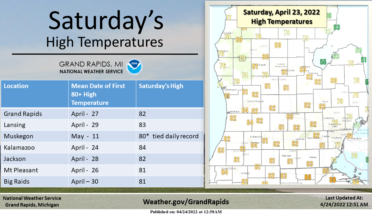
High Temperatures reached the lower 80’s across the area on Saturday. The last time most of Southwest Michigan has highs of 80 or more was on October 11th, of 2021. For just about all of our reporting stations that have long period records, Saturday’s high in the 80s was about a week early. For Muskegon it was a little more than 2 weeks early. The mean date is based on data from 1991 to 2020 (official climate normal period).
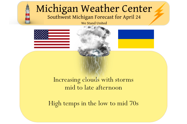
Today we will see another warm day before we transition back to a cooler weather pattern. Clouds will be on the increase during the mid to late morning. Thunderstorms are expected to cross the area this afternoon with the strongest storms from midafternoon into early this evening. An isolated severe thunderstorm is possible. The greatest overall threat is for localized flooding from heavy rainfall.

This is a slight risk for severe thunderstorms over most of Southwest Lower Michigan this afternoon into this evening. The threat exists over all of Southwest Lower Michigan, however, the greatest threat seems to be in the I-69 area during the mid to late afternoon. It is possible an isolated tornado could occur with the strongest storms. Most locations should expect some thunderstorms this afternoon into the evening with locally heavy rainfall and frequent cloud to ground lighting. Given how wet most of the area already is from recent rainfall be on the lookout for water over the road and if you see that please try to find another way to where you’re going. By far, the most likely threat for most of us in Southwest Michigan is the locally heavy rainfall.
Harzardous Weather Outlook
.DAY ONE...Today and Tonight

Strong to locally severe thunderstorms will be possible this
afternoon and evening. The highest chance of severe weather will
be between 3 pm and 10 pm this evening. The highest threat will be
strong winds, with large hail, locally heavy rainfall, and isolated
tornadoes also possible. Areas east of a line from Mt. Pleasant to
GR to South Haven will have the highest chance for severe weather.
Forecast Discussion
-- Severe weather remains possible this afternoon/evening --

Our biggest potential impact weather over the next seven days looks
to be the severe threat this afternoon/evening across portions of
the area.

There has not been a lot of change generally speaking over the last
few model runs regarding this potential event this afternoon. The
biggest potential looks to occur over the SE portion of the area,
roughly east of a South Haven-GR-Mt. Pleasant line. East of this
line is where there is good agreement that there will be less in the
way of pcpn and cloud cover, and better heating will take place.

These favored areas could see temps approaching 80 degrees with dew
points up around 60F once again, which would increase ML CAPE values
over 1,000 J/kg. This is not ideal, but could be enough for some
severe weather given favorable shear values. Effective shear values
off of forecast soundings indicate up around 50 knots of deep layer
effective shear with the mid level jet being close by. These shear
values will give storms that develop a chance to become strong to
severe.

All hazards do look to be in play for the area with this potential
event. We expect a scattered to broken line of convection orientated
from SW to NE to develop or strengthen near the differential heating
boundary that separates the better instability from lesser amounts.
Low level 0-3km shear vectors indicate they will be fairly parallel
to the line. The wind fields would support a wind threat where the
shear vectors are more perpendicular to the storms. Mid level lapse
rates are around 6.5 C/km or so, with somewhat thinner CAPE
profiles. Finally, a tornado threat does exist as there is enough 0-
3km shear with the low level jet overhead. Also, forecast hodographs
show some decently curved profiles with veering winds.

We believe the best time for severe weather will be from around 3-7
pm before the line would move east of the area.

Additional showers and embedded storms will be possible after the
line ahead of the cold front. SE areas would be favored for
additional rain.

-- Colder early this week with rain/snow chances --

We will see a secondary cold front and upper trough move through
during the daylight hours of Monday. This scenario will keep temps
from warming much as the colder air floods in at that point. There
is not really expected to be any rain with the secondary front as
the atmosphere is quite dry at that time.

We will see precipitation chances increase some for Tuesday. Favored
areas will be across the north where the upper trough diving over
the region will be more centered on. 850 mb temperatures are
forecast to drop to -5 to -10C by late Tuesday afternoon.
Instability/cold pool showers will develop with the next upper wave
moving overhead. The air will be cold enough to support some snow
showers on Tuesday.

-- Moderating temps with small rain chances mid-late week --

The upper trough and associated showers will move out of the area by
Wednesday morning, and high pressure will build in. There is a
fairly decent upper ridge slowly building in. At the sfc, high
pressure centered near Hudson Bay will drive cool and dry air down
from the NE. This ridging at the sfc and aloft will still around,
and help to dry things out a bit. Temperatures will slowly moderate
as return flow gradually sets up. The air will be dry enough that a
couple of week systems that try to move in will not be able to
sustain pcpn for a bit, maybe until next weekend.
Severe thunderstorm warning for Eaton county and that storm is hitting us right now. Not severe levels, I believe, but heavy rain with 30-ish mph wind gusts.
Back to back 80-degree days culminating in a nice thunderstorm. It’s been a great weekend.
Today is yet another way why Grand Rapids has a cooler mean temperature at this time then some locations to the east. The clouds and rain moved into Grand Rapids earlier than at Lansing and Detroit and thus the high at Grand Rapids was just 74 and it was 77 at Lansing and 83 at Detroit. At this time there is light rain falling here with a temperature of 67.
Slim
I would Imagine 40’s in the last week of April for highs are probably unheard of ….INDY
And some lows in the mid 20’s. incredible!
Highs in the mid 40’s and lows in the mid to upper 20’s would be some of the coldest at Grand Rapids for both Tuesday and Wednesday. So while not unheard of kind of rare.
Slim
Had some light to moderate rain move thru a total of 0.21″ of rain has fallen so far today.. No thunder with that rain here and on radar it looks like the back edge will soon come thru. The current temperature here is 68 with light rain falling.
Slim
MD issued:
https://www.spc.noaa.gov/products/md/md0556.html
2022 has been very cold! Well below normal temps and more to come! Absolutely incredible!
3rd warmest April 23rd ever. Wow! Saw lots of swimmers all the way in Lake Michigan yesterday. And it’s only April!
If that is the case there must be really not to bright people out there. The current water temperature at Holland and South Haven is a cold 42. The current air temperature at Holland Buoy water front is 53 and at South Haven it is a warmer 63. Not the best conditions to spend much time in the water.
Slim
Rock on Slim! Anyone in lake MI yesterday needs to have their head examined! Ridiculous!
Thunderstorm Hector:
https://www.cnn.com/2022/04/02/weather/weather-thunderstorm-hector-australia/index.html
👍
There has been some talk on here as to why some locations are cooler than other locations. Well that could be because some locations are cooler than other locations. My wife and I took a road trip up to Bay City yesterday and came back last night. On the way up the car thermometer was rather steady in the low 80’s with reading between 82 and 83. But on the way home boy was there big spread. The temperature started out at Bay City at 72 and varied between that 72 and 68 between Bay City and Mt Pleasant. Between… Read more »
Of course that is all true and logical! Some just can’t admit it has been a very cool 2022 and they just want to find any excuse to not face reality! Crazy!
Except the recent readings seem to be much further than the long term averages which of course account for what you said.
Yesterdays official H/L at Grand Rapids was 82/46. That high of 82 was the 3rd warmest April 23rd at Grand Rapids. At Muskegon they tied a record for the day with a high of 80 that ties 1985. At Lansing their high was 83 and that is their 2nd warmest April 23. So all in all just as advertised huge one day warm up. The official overnight low at Grand Rapids looks to have been 66. Here at my house my overnight low was 64. At the current time I have 67 and cloudy skies. There is a thin line… Read more »
Get ready for a long stretch of below normal temps! All CPC maps show us entrenched in below normal temps! 6-10 day, 8 to 14 day, 3 to 4 week and the Monthly outlook for May! An absolutely incredible trend! Hopefully this keeps up all summer long! Who in their right mind would want 90’s in the summer? Rock n roll will never die baby!