June and Meteorological Summer
We are now about to jump into June and the start of meteorological summer. Before we do just a short note on the anniversary of the 1998 derecho that blew thru here on May 31st Note this is the 24th anniversary not the 23rd
https://www.woodtv.com/weather/bills-blog/the-famous-derecho-of-may-31-1998/
Before we look at the averages and records for June and the summer months lets take a look at this past May and the spring season. This past spring had a mean at Grand Rapids of 51.3 the 30 year mean for spring at GR is 47.5 so this spring was +3.8 above average. The past spring had 9.57” of rainfall average at Grand Rapids is 10.38 for a departure of -0.81” there was a total of 7.2” of snowfall average is 9.6” so the departure was -2.4” The highest temperature this spring was 85 and the lowest temperature was 17. The last low of 32 or below was 28 on April 25th
June is of course the start of meteorological summer it has the most hours of daylight and the average H/L at Grand Rapids starts out at 75.3/54.1 on the 1st and rises to 82.3/61.5 on the 30th The average 30 year mean is 68.1 and the new 15 year average mean is 69.1. The warmest 5 Junes are 74.2 in 1919. 74.0 in 1933. 73.4 in 1921. 73.2 in 1934 and 72.8 in 2005. The coldest 5 are 61.8 in 1969. 61.9 in 1928. 62.0 in 1958. 62.3 in 1926 and 62.5 in 1945. The record highest day is 102 on June 1st 1934 and June 20th 1953 the all time low is 32 on June 4th 1945. The average number of days with highs of 80 or better is 14. The most days of 80 or better is 25 in 1919 the June with the least was 1916 with just 2 days of 80 or better. The average number of days with highs of 85 or better is 8 the most is 18 and that happened on 4 years. There have been 5 years when there we no days of 85 or better. The average number of days of 90 or better is just 3 the most is 14 in 1894 and there have been a total of 37 years when the high did not reach 90 or better in June. The record low for June is 32 on June 4th 1945 it was just 33 on June 11th 1972. The warmest low (for the whole month) was 52 in 1934 in 1938 it did not get any colder than 51 and in 2008 and 2005 it did not get below 50. The wettest June was in 1892 when a reported 13.22” of rain fell. Last year Grand Rapids had 1.69” The driest June was in 1988 when just 0.25” fell in the whole month. June, last year had a mean of 68.8that was -0.1 below average.. The high for the month was 91 on the 1st and 2nd and 21st . the low was 47 on the 7th there were 6 days of 90 or higher. And 4 nights fell into the 40’s.
Here is the latest guess for June 2024
https://www.cpc.ncep.noaa.gov/products/predictions/long_range/lead14/
At Grand Rapids the average mean for meteorological summer is 68.9 using the 30 average and 69.1 using the 15-year average. The warmest summer in recorded history at Grand Rapids is 74.7° in 1955. The 2nd warmest is 73.6 in 2012. The coldest is 1992 with a mean of 65.5. Last year the mean was 72.5. The wettest was in 1994 with 22.63” and the driest was way back in 1894 with 3.03” Last year Grand Rapids recorded 15.26” of rain fall. On average Grand Rapids has a little over 60% of possible sunshine. On average the hottest day of the year is 92. There have only been two summers when the temperature did not reach 90 or better. The current 30 year average number of days of 90 or better is just 9 the record number. The most was 36 in 1988 and the least was 0 in 1951 and 2014. Last year there were 14 days of 90 or better. The Summer solstice this year will be on June 20th at 4:50 PM EDT. After that date the number of hours of daylight will start their decline towards fall and then winter.
The official H/L yesterday at Grand Rapids was 77/46 there was no rainfall the total rainfall for May 2024 was 3.16” that is a departure of -0.84”. There was 84% of possible sunshine yesterday. For today the average H/L is 75/54 the record high of 102 was set in 1934. The record low of 36 was set in 1993. The most rainfall of 2.65” fell in 1970. Last year it was a hot 91/63
AREA FORECAST DISCUSSION
NATIONAL WEATHER SERVICE GRAND RAPIDS MI
319 AM EDT SAT JUN 1 2024
KEY MESSAGES
– RAIN AND SLIGHT CHANCE THUNDERSTORM THIS AFTERNOON-TONIGHT
– LINGERING HUMIDITY AND CLOUD PATCHES ON SUNDAY
– MEDIUM/HIGH CONFIDENCE IN EVOLUTION OF UPPER TROUGHING NEXT WEEK
DISCUSSION
ISSUED AT 319 AM EDT SAT JUN 1 2024
– RAIN AND SLIGHT CHANCE THUNDERSTORM THIS AFTERNOON-TONIGHT
MIDLEVEL TROUGH AND SURFACE LOW OVER MISSOURI WILL MOVE INTO
ILLINOIS TODAY. AHEAD OF IT, DRY AIR WILL BE IN PLACE THROUGH EARLY
AFTERNOON IN MICHIGAN WITH DEW POINTS AT OR BELOW 50. HIGH AND MID
ALTITUDE CLOUDS WILL THICKEN AS PRECIPITATION NUDGES CLOSER,
EVENTUALLY MOISTENING THE LOW LEVELS AND COOLING OFF TEMPERATURES
ONCE RAIN REACHES THE SURFACE THIS AFTERNOON-EVENING.
HREF AND GLOBAL MODEL ENSEMBLES HAVE COME INTO MUCH BETTER ALIGNMENT
COMPARED TO 24 HOURS AGO REGARDING RAIN CHANCES, AND NOW THE
SCENARIO FOR LITTLE TO NO RAIN SEEMS TO BE REMOTE, AT LEAST FOR
AREAS SOUTH OF US-10. THE ARRIVAL OF RAIN IS LIKELY IN WEST MICHIGAN
DURING MID-LATE AFTERNOON (3-5 PM OR SO) AND NEAR US-127 DURING THE
EVENING (8-9 PM). RAIN SHOULD MOVE OUT LATE IN THE NIGHT OR EARLY IN
THE MORNING.
FORECAST SOUNDINGS DURING THE MIDDLE OF THE EVENT SHOW MOISTURE AND
LIFT THROUGH MUCH OF THE TROPOSPHERE. LAPSE RATES IN THE LOW-MID
LEVELS THAT ARE NEUTRALLY BUOYANT AND POSSIBLY SLIGHTLY UNSTABLE FOR
MOIST PARCELS MAY ALSO SUPPORT A PERIOD OF MORE EFFICIENT RAINFALL
PRODUCTION IN SOME SPOTS. THE CHANCE OF LIGHTNING IS SLIGHT BUT NOT
ZERO. BROADLY, 0.25 TO 0.75 INCH RAIN TOTALS ARE MOST FAVORED BUT
THERE COULD BE EMBEDDED SPOTS OR SMALL SWATHS OF 1 TO 1.5 INCH
TOTALS, PER ENSEMBLE GUIDANCE.
– LINGERING HUMIDITY AND CLOUD PATCHES ON SUNDAY
MOISTURE IN THE LOW LEVELS WILL LINGER ON SUNDAY AS THE TROUGH
DEPARTS, AND THERE MAY BE DRIZZLE EARLY IN THE DAY. TEMPERATURES
SHOULD WARM BACK UP TO SEASONABLE LEVELS BUT DEW POINTS NEAR 60 WILL
MAKE IT FEEL A LITTLE MORE STICKY. THE HRRR IS LESS ENTHUSIASTIC
ABOUT RIDGING AND WARMING IN THE MIDLEVELS, SO IT DOES TOUCH OFF
SOME AFTERNOON SHOWERS SOUTH/EAST OF GRAND RAPIDS. WILL GO WITH A 10
PERCENT CHANCE OF MEASURABLE RAINFALL.
– MEDIUM/HIGH CONFIDENCE IN EVOLUTION OF UPPER TROUGHING NEXT WEEK
ENSEMBLE SPREAD IS LOWER THAN USUAL AND GOOD RUN TO RUN CONSISTENCY
IS INDICATING HIGHER CONFIDENCE IN THE DETAILS FOR SENSIBLE WEATHER
NEXT WEEK.
THERE CONTINUES TO BE A SIGNAL FOR RAIN MONDAY AND TUESDAY AS A
SHORTWAVE TROUGH APPROACHES AND MINORS OUT…THEN A STRONGER
SIGNAL ON WEDNESDAY AS A WELL-DEFINED SHORTWAVE CUTS OFF AS IT
APPROACHES FROM THE NORTHERN PLAINS. THIS LOW FIGURES IN THE
EVOLUTION OF PERSISTENT TROUGHING ACROSS THE GREAT LAKES BY THE
END OF THE WEEK WITH LOWER 500 MB HEIGHTS AND LOW LEVEL NORTHWEST
FLOW INDICATING COOLER THAN NORMAL TEMPERATURES INTO NEXT WEEKEND.
Detailed Forecast for Grand Rapids
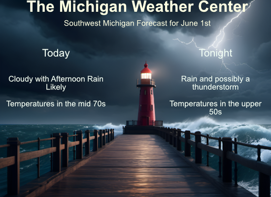
Today
Rain likely, mainly after 5pm. Mostly cloudy, with a high near 77. South wind 3 to 7 mph. Chance of precipitation is 60%. New precipitation amounts between a tenth and quarter of an inch possible.
Tonight
Rain and possibly a thunderstorm before midnight, then a chance of rain. Low around 60. East northeast wind around 5 mph becoming calm in the evening. Chance of precipitation is 80%. New precipitation amounts between a quarter and half of an inch possible.
Sunday
Cloudy, then gradually becoming mostly sunny, with a high near 77. Calm wind becoming east around 6 mph.
Sunday Night
Partly cloudy, with a low around 57. Light and variable wind.
Monday
A 20 percent chance of showers after 2pm. Mostly sunny, with a high near 83. Light southeast wind becoming south southeast 5 to 9 mph in the morning. Winds could gust as high as 21 mph.
Monday Night
Showers likely and possibly a thunderstorm, mainly after 2am. Mostly cloudy, with a low around 65. Chance of precipitation is 60%.
Tuesday
A chance of showers, with thunderstorms also possible after 2pm. Partly sunny, with a high near 84. Chance of precipitation is 40%.
Tuesday Night
A chance of showers and thunderstorms, then showers likely and possibly a thunderstorm after 2am. Mostly cloudy, with a low around 67.
Wednesday
Showers likely and possibly a thunderstorm. Partly sunny, with a high near 81.
Wednesday Night
A chance of showers and thunderstorms before 2am. Partly cloudy, with a low around 59.
Thursday
A chance of showers. Mostly sunny, with a high near 74.
Thursday Night
A chance of showers. Partly cloudy, with a low around 56.
Friday
A chance of showers. Mostly sunny, with a high near 72.
No heat waves in sight! Just plenty of near to below normal temps! Rock n roll will never die! I am in a great mood!
Here is the latest guess for June
https://www.cpc.ncep.noaa.gov/products/predictions/long_range/lead14/
Slim