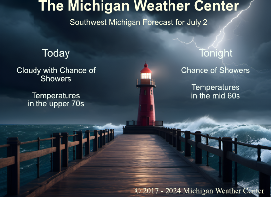
With below-normal temperatures yesterday in the mid-70s it was a perfect day to work or play outdoors. Our high was 74° and the morning low was 47°. We have some showers coming across the lake this morning so chances of rain will remain in place throughout the day.
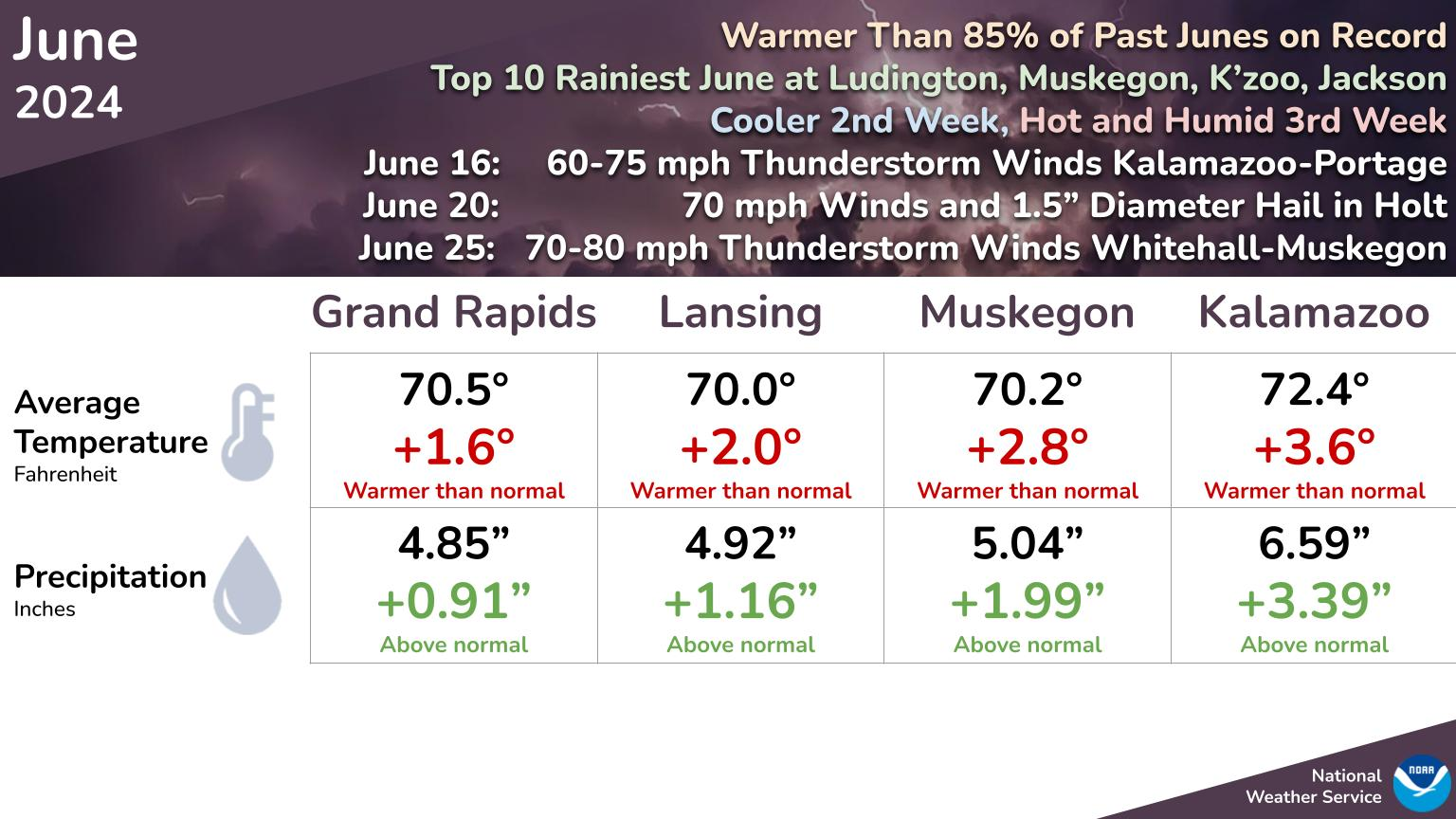
June Summary
NWS Forecast
Weather History
1973: A tornado struck two miles east of Leslie in Ingham County, damaging a car, mobile home, and several farm buildings.
2001: Frost and freezing temperatures were observed in some locations with a 29-degree temperature recorded in Grant, Michigan in Newaygo County. The 39 degrees at Muskegon was the coldest July temperature on record there.
2008: A line of severe thunderstorms brought high winds, large hail, and some flooding from Muskegon to Grand Rapids and Lansing, south to Kalamazoo. In western Allegan County, winds estimated up to 75 mph brought down dozens of trees and snapped eight power poles. A roof was blown off a home in Kalamazoo County. Hail up to 1.75 inches in diameter caused damage in Muskegon County.
On July 2, 2019, a round of severe thunderstorms moved through the region, mainly along the I-96 corridor southeast from southern Shiawassee/northern Livingston to the coast of Lake St. Clair and east along the Washtenaw-Lenawee and Wayne-Monroe County lines. These mainly produced wind gusts to 60 mph and some hail up to 1 inch was reported near the Livingston-Washtenaw County line.
On July 2, 2011, a hot and humid day with heat indices around 100 degrees ended with numerous severe thunderstorms across southeast Michigan as a cold front moved through the region. There were over 50 reports of severe weather including hail up to 2 inches in diameter and measure wind gusts to 65 mph at Willow Run and Detroit Metro Airports.
On July 2, 2009, high temperatures only reached the mid to upper 60s across Southeast Michigan including 68 in Detroit, 65 in Flint, and 67 in Saginaw. This was just a day past high temperatures of 72 in Detroit, 67 in Flint, and 63 for Saginaw. The cold start to July 2009 continued through most of the month as Flint and Saginaw recorded their coldest July, and Detroit recorded the 3rd coldest July.
Also on July 2, 1997, A strong cold front spawned a very notable severe weather event over Southeast Lower Michigan which was marked by 13 tornadoes. This is the largest number of tornadoes in SE Mich reported in a single day since records have been kept! The tornadoes included two F3s in Genesee County and an F2 tornado in Detroit-Highland Park. Two deaths resulted from the tornadoes (one in Genesee County and one in Oakland) and 5 deaths from severe thunderstorm winds in Wayne County, Grosse Pt Farms.
Forecast Discussion
- Chance of Showers and Scattered Thunderstorms Through Wednesday

Warm advective pattern over Lower Michigan resumes on the west
side of the departing high pressure area, while a weak surface low
associated with an upper-level shortwave trough will organize
over Iowa and move toward Northern Michigan tonight. As midlevel
moisture streams in today, altostratus clouds will thicken and
occasionally produce precip amid isentropic lift and perhaps some
weak and shallow instability layers. The lower atmosphere is still
fairly dry so will tend to reduce the precip to sprinkles south
of I-96. North of Muskegon to Mt Pleasant has the better chance of
measurable rainfall during the day.

Continued 850-700 mb moisture advection tonight and slightly
cooler air above may yield instability deep enough for scattered
thunderstorms, especially NW of Grand Rapids. HREF member models
overall are not producing much convection given the limited
instability and lifting mechanisms. If storms do occur, forecast
soundings are still fairly dry below 5,000 feet, and with low-
level winds just above the stable surface layer increasing to 40+
knots, there is potential for locally gusty conditions early Wed.

On Wednesday, the surface trough / weakening cold front will
progress east of most of the CWA, leaving the chance of afternoon
convection development constrained to near and south/east of
Jackson.

- Risk for Stronger Storms Friday

The ECMWF continues to advertise a stronger southwesterly upper
level jet streak arriving here in MI during the day on Friday. A
digging 500 mb trough forms into a closed low as is tracks
northeastward through the state. The surface pattern shows a weak
warm front extending eastward through the CWA midday Friday before
lifting northeast of the CWA later in the afternoon. Deep layer
shear and surface based instability both show favorable setup for
at least a period of organized storms as the instability axis
shifts northeast through the region during the early to mid
afternoon hours on Friday. The GFS is similar to the ECMWF with
the setup, although it is several hours slower with the warm front
and instability axis shifting through the region and the Canadian
is even slower than the GFS. Thus, uncertainty exists with the
timing, which will be important when determining how much if any
impact the region see`s from the storms. The various model
ensemble qpf output shows considerable spread in the values
amongst the members so that adds the the uncertainty. For now, we
will continue to feature higher POPs for Friday throughout the CWA
as most ensemble members are showing measurable values.
The overnight low here in MBY was 59 there was no rainfall. At the current time it is cloudy and 62.
Slim
The official H/L yesterday at Grand Rapids was 74/47 there was no rainfall. The highest wind gust was 17 MPH out of the E. The sun was out 93% of the time. For today the average H/L is 83/62 the record high of 98 was set in 1910 the record low of 43 was set in 2001. The warmest low of 74 was set in 1911 the record coldest high of 67 was set in 2009. The most rainfall of 3.18” fell in 2008. Last year the H/L was 78/69 and there was 0.29” of rain.
Slim