Well, the first third of summer is closing out and the temperatures were warmer than normal and wetter than normal for the Allegan County and Otsego. We ended up with six inches of rain for June and everything is green and lush. Yesterday the temperature was 81° with a morning low of 68°. Today we will end the month with below-normal temperatures around 70° and breezy conditions.
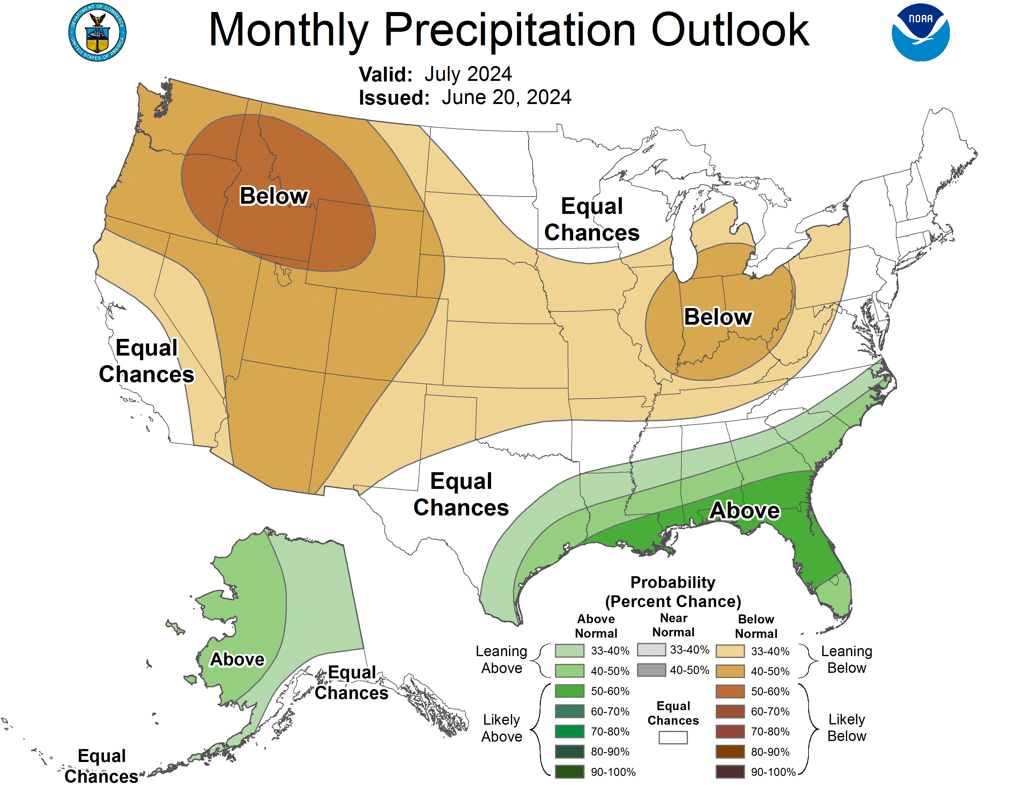
July CPC Outlook

...BEACH HAZARDS STATEMENT REMAINS IN EFFECT THROUGH THIS
EVENING...

* WHAT...High wave action, strong currents, and dangerous
  swimming conditions expected. Piers may be heavily swamped by
  waves.

* WHERE...Mason, Oceana, Muskegon, Ottawa, Allegan and Van Buren
  counties.

* WHEN...Through this evening.

* IMPACTS...Strong currents can pull swimmers into deeper water
  and high waves can sweep people off piers.

* ADDITIONAL DETAILS...Conditions will be especially hazardous on
  the north side of piers.
NWS Forecast
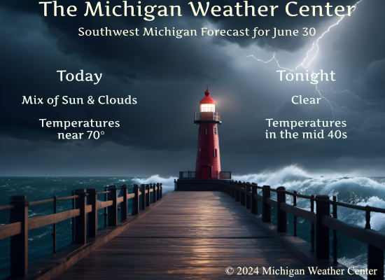
Today
Mostly sunny, with a high near 70. North northwest wind around 10 mph, with gusts as high as 22 mph.
Tonight
Clear, with a low of around 45. North northwest wind 5 to 8 mph becoming calm after midnight. Winds could gust as high as 18 mph.
Monday
Sunny, with a high near 76. Calm wind becoming east around 5 mph in the afternoon.
Monday Night
Partly cloudy, with a low of around 54. Southeast wind 3 to 5 mph.
Tuesday
A 20 percent chance of showers. Partly sunny, with a high near 79. South southeast wind 6 to 11 mph, with gusts as high as 22 mph.
Tuesday Night
There is a chance of showers, then showers likely, and possibly a thunderstorm after 2 am. Mostly cloudy, with a low of around 67. The chance of precipitation is 60%.
Wednesday
Showers are likely, mainly before 8 am. Mostly cloudy, with a high near 84. The chance of precipitation is 60%.
Wednesday Night
Partly cloudy, with a low around 65.
Independence Day
Partly sunny, with a high near 82.
Thursday Night
There is a chance of showers. Mostly cloudy, with a low of around 62.
Friday
There is a chance of showers. Mostly sunny, with a high near 83.
Friday Night
There is a chance of showers. Partly cloudy, with a low around 63.
Saturday
Mostly sunny, with a high near 79.
Weather History
1931: June ended on a hot note with highs in the upper 90s after morning lows in the mid-70s.
On June 30, 1927, Detroit’s overnight temperature dropped to only 75 degrees.
Forecast Discussion
- Cooler Today and Monday With Much Less Humidity

Today and Monday`s weather will be governed by synoptic scale
ridging and surface high pressure that will translate eastward
through the Midwest and Great Lakes. Following Saturday night`s cold
frontal passage, cold air advection this morning is ushering in 850
mb temperatures by 18Z that are at least 10 Celsius cooler than 24
hours ago. The feel of humidity will be drastically lower today
compared to yesterday, with dew points no longer around 70 F but
instead around 50 F. Partly cloudy skies this morning with
stratocumulus should give way to plenty of sunshine by afternoon as
much drier midlevel air infiltrates into the diurnal PBL.

- Potential for Thunderstorms Late Tuesday into Early Wednesday

A southwesterly low level jet moves into the CWA during the day on
Tuesday.  This feature will advect in a moist and unstable airmass
by the afternoon.  PWAT`s are progged to climb up to around 2 inches
Tuesday night.  A weakening cold front is shown to push down from
the northwest later Tuesday night or early Wednesday morning with
scattered to numerous showers/storms forming out ahead of it. Models
are in relative agreement on this scenario. Ensemble QPF trends
still support higher POP`s during this period as most members are
showing measurable QPF. Ensemble wind gusts from the GFS and ECMWF
have a signal for gusty conditions as well. Values over 25 knots are
looking possible.
Great bomb fire weather with lows in the 40’s stoked that fire up and stay warm! Not sure if it’s October or the end of June ?? Let’s Goooo! INDY
Great, great, great weather day! Give me this all summer long baby! Rock n roll will never die!
Here is the updated CPC guess for July 2024
https://www.cpc.ncep.noaa.gov/products/predictions/30day/
What? Near normal temps! I love it!
Today is a great day to go hiking through the woods. Everyone enjoy the day!
I 100% agree! Keep it rocking!
Thinking I will pick more raspberries and make another batch of jam. There are a lot of berries out there.
The overnight low here in MBY was 57 I had a total of 0.45” of rainfall yesterday while the official amount was 1.10” At the current time it is clear and 59 here with a DP of 48. There should be an update to the July outlook later today.
Slim
The official H/L yesterday was 81/68 there was 1.10” of rainfall the sun was out 35% of the time the peak wind gust was 26MPH out of the NW. For today the average H/L is 83/62 the record high of 99 was set in 1931 the coldest high of 61 was set in 1962 the record low of 40 was set in 1943 the warmest low of 78 was set in 2018. The most rainfall of 1.69” fell in 1938. Last year the H/L was 89/64.
Slim
I’ve put off a few outdoor projects because it’s been just too warm and humid. Today is the day. Cool, dry, and breezy. Have a great day, friends.
Got a heavy shower at my house last night around 11:15. This morning the sky has a fall look to it. In about 2 more months meteorological fall begins.
It looks and feel more like mid to late September this morning.
Slim
Yes indeed!
Great cool temps today and beyond! Who would have thought? Keep the below normal temps rocking! Incredible!