
OK, we have looked at some heat waves in the last few weeks I thought it would now be a good time to look as some past summers that were on the cool side. I know that way back in 1816 will come to mind and of course 1992 but today I will look at one of the coolest July’s on record that happened not that long ago.
2009
This was the coldest July on record for the nine-state Midwest region, based on preliminary temperature data. The average temperature for the region was 68.0 degrees, 4.7 degrees below normal. The previous record was 68.9 degrees in 1992, according to Mike Timlin, Regional Climatologist with the NOAA Midwestern Regional Climate Center (https://mrcc.isws.illinois.edu).
It was the coldest July on record for Indiana, Illinois, and Iowa; the second coldest on record for Michigan, Kentucky, Ohio, and Wisconsin; the third coldest in Minnesota; and the fourth coldest on record for Missouri. Records for the region date back 114 years.
Timlin says that more than 400 record low minimum temperatures and 1,300 record low maximum temperatures (lowest high temperature) were set during July across the nine-state region.
“Temperatures were below normal for most of July with two particularly cold periods. The first was July 1-9, and the second was July 17-23,” states Timlin.
There were 370 record low maximum temperatures set during the period July 1-9, and 23 record low minimum temperatures. Temperatures ranged from 2 degrees below normal in southern Missouri to as much as 8 degrees below normal in the Michigan Upper Peninsula.
During the period from July 17 to 23, temperatures were 10 to 12 degrees below normal across Iowa, Missouri, much of Illinois, southern Indiana, and western Kentucky, and 6 to 9 degrees below normal across the remainder of the region. A total of 942 record low maximum temperatures and 337 record low minimum temperatures were established over this seven-day period.
Many locations in the central Midwest did not reach 90 degrees at all during the month. Typically, the number of days with temperatures reaching 90 degrees or above ranges from 10 to 15 from southern Missouri eastward through Kentucky, and three to five in the northern third of the region.
Louisville, KY normally has about 12 days of temperatures 90 degrees or above in July, and recorded none this July. St. Louis, MO normally experiences 16 days with temperatures 90 degrees or above, and recorded only four in July.
International Falls, MN did not report a single day 80 degrees or higher, and experienced its coldest July on record with an average temperature of 58.8 degrees, breaking the old record of 59.4 degrees set in 1992.
Other locations in the Midwest that had a record cold July include:
* Madison, WI – average temperature of 65.7 degrees, old record 66.7 degrees in 1891
* Grand Rapids, MI – average temperature 67.1 degrees, old record 67.2 degrees in 1992
* Cedar Rapids, IA – average temperature 66.2 degrees, old record 69.9 degrees in 2004
* Rockford, IL – average temperature 67.0 degrees, old record 69.0 degrees in 1915
* South Bend, IN – average temperature 68.3 degrees, old record 68.5 degrees in 1996
* Cincinnati, OH – average temperature 70.1 degrees, old record 70.7 degrees in 1947
* Frankfort, KY – average temperature 71.5 degrees, old record 75.2 degrees in 1947
In Missouri, Columbia recorded its second coldest July on record with an average temperature of 72.3 degrees. The record is 72.2 degrees in 1924.
July precipitation was normal to above normal from southwestern Minnesota to southern Ohio and eastern Kentucky. Rainfall was less than 50 percent of normal from south-central Minnesota across much of Wisconsin. Parts of central Minnesota, much of the northern half of Wisconsin, and the western half of the Michigan Upper Peninsula remained in moderate to severe drought at the end of the month, according to the U.S. Drought Monitor
July 2009 mean temperature at Grand Rapids of 67.1 made it the coolest July in recorded history here at Grand Rapids. It beat out the July of 1992 by 0.1° From June 28 to July 28th there were 31 days in a row of below average temperature and for the whole month of July 2009 there was just one day that was warmer than average. The average high at Grand Rapids in July is 83 and it did not get that warm that year until July 28th and that was the only day. The high that day was the warmest for the whole month at just 84 The low for the month was 50 and that happened 3 nights on the 8th and then the 13th and 14th For a comparison July 2009 was more like a typical July up at the Sault.
I received this Email yesterday I was surprised that I have has so many reports.
750 Reports!
Thank You!
According to our database, you have surpassed 750 reports.
Spectacular!
Thank you for being such a great volunteer.
The CoCoRaHS Team
appreciates
James
MI-KN-33
943 Observations
We really appreciate all that you do for us. Please let us know if we can do anything to make your CoCoRaHS experience any better. Thanks again!
Slim
Here is the SPC outlook :
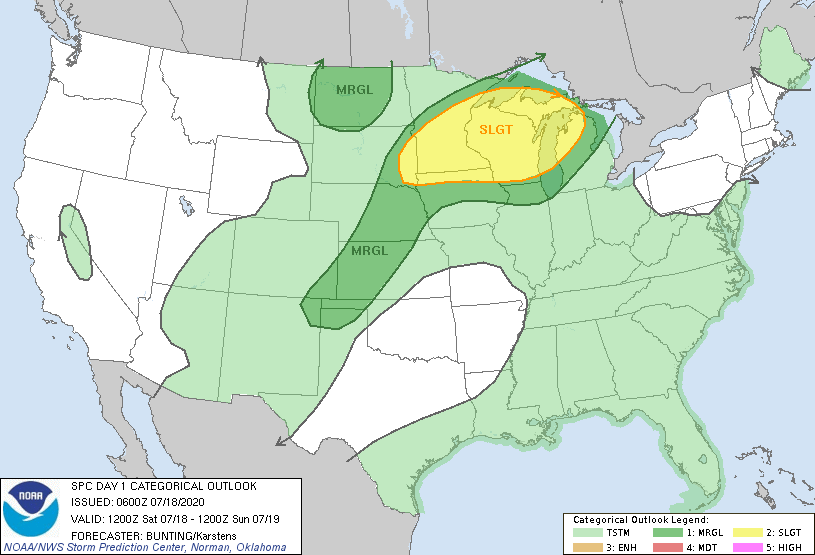
Today will be breezy hot and humid. Heat Index values are
expected to exceed 100 degrees for soever hours near and south of
I-96 today. Area north of there will have heat index values in
the 95 to 100 range. Prolonged exposure outside may result in
heat stoke.

There is an very low chance that thunderstorms could reach as far
south as Route 10 late this morning.

Tonight strong to severer thunderstorms with locally heavy rain
are expected, mostly over the northern third of our forecast area.
Training thunderstorms could lead to excessive rainfall, causing
localized flooding. Some of the thunderstorms could have gusty
winds, strong enough to cause trees and power lines to come down
resulting in power outages. Most of these storms are expected to
be after midnight.
Heat – what heat?. Rain – what rain?
Coming UP on 4:20am on this Sunday Morning….take a guess what I will be doing. LOL
Anyways here is some weather HISTORY for Today’s DATE
July 19
1894: Temperatures reach 100 degrees across much of Michigan for the second day in a row. At Lansing, the high of 102 degrees ties the record for the all time hottest temperature.
2009: Cool and unstable air over Lake Michigan spawns at least two waterspouts. One of the waterspouts moves inland near Holland, just north of Lake Macatawa, but quickly dissipates and causes no damage.
Check it out
Severe Thunderstorm Warning MIC041-109-153-190830- /O.NEW.KMQT.SV.W.0029.200719T0742Z-200719T0830Z/ BULLETIN – IMMEDIATE BROADCAST REQUESTED Severe Thunderstorm Warning National Weather Service Marquette MI 342 AM EDT Sun Jul 19 2020 The National Weather Service in Marquette has issued a * Severe Thunderstorm Warning for… Central Delta County in south central Upper Michigan… Central Menominee County in south central Upper Michigan… Central Schoolcraft County in east central Upper Michigan… * Until 430 AM EDT/330 AM CDT/. * At 342 AM EDT/242 AM CDT/, severe thunderstorms were located along a line extending from 10 miles southwest of Steuben to near Escanaba to 9 miles south of Pembine,… Read more »
Well a Good Sonday Morning to my old weather hobos and geeks.
Racking tracking and Stacking storms overnight. Hopefully West MI and my neck of the Woods ( Allendale) gets some YUGE Storms. I’m currently in FB jail again.
So I’m BACK here to rack track and stack on here.
Almost 9 p.m. and with the dew point now at 75 the heat index is an unbelievable 93 degrees! Some places have a dew point of 77 right now, just down right oppressive. Doesn’t get much higher than that around here.
The current temperature here at my house is 84 with a DP of 73.
Slim
So much for high temps in the mid 90’s and heat index in the mid 100’s. More warm weather hype! Incredible!
Finally feels like Summer…
91 degrees with a heat index of 101. Just plain nasty.
The current temperature/DP here at my house is 91/72. The last reading at GRR was 89/72. I did some work in the back yard and while it is not too bad in the shade it sure is hot in the sun. Now I am indoors where it is nice and cool. There is a area of rain with a thunderstorm about mid lake at this time. If this holds together there could be some rain in the GR area later today.
Slim
Not too bad outside yet! Heat index is under 100 degrees with a nice breeze!
Wasn’t there supposed to be a heat wave #2 this week from the heat hype talk last week on here?? Even some of the locals fell of there rockers a little with thoughts for this week ..Yes the brezze is a beautiful thing today …Have a nice Saturday…..INDY
You know it! Rock on Indy!
Wow, that is some thick air out there today! Dew point up to 74 at noon already with the heat index in the mid 90’s. Nothing refreshing about it today. 👎
You know it’s going to be a hot one when it’s 80 by 9:30. Came inside for lunch and to cool off for a bit.
Drove up to Sparta at 11:30pm last night. Well worth the trip as the Comet is very impressive…easily the largest object I’ve ever seen in the night sky.
Glad you got to see it! It is a very impressive sight! I’ve probably viewed 40 to 50 comets in my lifetime and this is #1 by far!
We took a few mins ro catch it as well. It is so cool!!!
currently 85 with a DP of 73 @ 10:15 in Otsego
The over night low here at my house was 64. Officially at GRR the low was 65. Currently the last reading at GRR was 76 with a DP of 69. Here at my house it it is cloudy and 78 with a DP of 70. At this time there is a area of thunderstorms over northern Lake Michigan and another area in NE Iowa.
Slim
It’s already been 11 years? Like my granddaddy used to say: Life is like a roll of toilet paper. The farther you go along, the faster it goes.
Heading to the lake to enjoy another hot day near and in the water. Have fun everyone.
Good read Slim! A cool July sounds good after this years July. In 2009 we were gone for most of it as we had a big family trip for almost 3 weeks to the Grand Canyon and the West coast. Wasn’t cool at all when we were in Arizona and Nevada!
While July of 2009 was cool here in the Great Lakes area it was hotter than average is the SW.
Slim
Thanks Slim –
Here is my CoCoRaHS report:
According to our database, you have surpassed 250 reports.
Michael VanLent
MI-AN-27
438 Observations