

Don’t think we will see anything like these photos in lower Michigan – the only thing I remember coming close was the winter of 1972 in northern Maine and central/southern Ontario Canada when I saw the house size snow blowers clearing Route 201 through the northern highlands of Maine all the way up to Quebec City. Bigger snowflakes up in the highlands and mountains with the cold air can cause tremendous snowfalls in a short amount of time…. Of course the other was the blizzard of January 26-27 1978 which brought most of Michigan to a stand still.
I have seen multiple circumstances where I have had to send the big dog out to make a path for the miniature poodle I used to have before I could get out to make doggie runs in the snow for them – I have a large back yard which is fenced all around so they have a large playground to go porpoising through the snow.
No big snow storms are in the short term – yesterday I said there was a hint of temps in the 60’s around Thanksgiving, now the GFS is showing snow – this is why I don’t trust long range computer models.
High pressure will bring fair and cold weather this week, but there will be a couple chances for some snow showers. The first will come Thursday into Friday when a cold front moves through and again on Saturday when low pressure tracks just south of Lower Michigan.
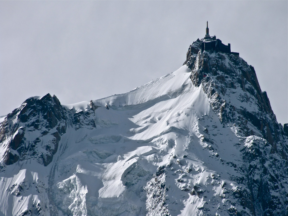
Will we see snows like in the photos below – nope – altitude figures into snow amounts – bigger flake size and the mountains act as a moisture trap – Boulder and Denver Colorado are good examples – one could see rain in the valleys and heavier snows the further one goes up into the mountains.

Most skiers know about the phenomenal snow year of 1998-1999 in Washington state’s Mt Baker ski area. 1,140 inches (95 feet) of snow fell to the ground over the course of the ski season.
The Pacific Northwest region of North America, which includes Alaska, British Columbia, Washington and Oregon, is the snowiest region of the continent. In many areas of Alaska and British Columbia, there are no meteorological stations, so we can only imagine how much falls during a given season. In Mount Rainier National Park, at the Paradise Ranger station, 1,224.5 inches (102 feet) of snow fell between February 19, 1971 and February 18, 1972. That is equal to the height of a 10 story building.
At Thompson Pass in Alaska, they enjoyed or suffered through, depending on your opinion, a great or horrific year in the winter of 1952-1953. That’s when 974.1 inches (81 feet) fell from heaven.
In 1963, that same area saw 78 inches fall in one 24 hour period. At this point, Alaska, Colorado and possibly Buffalo, New York are all claiming to have set the 24 hour record.
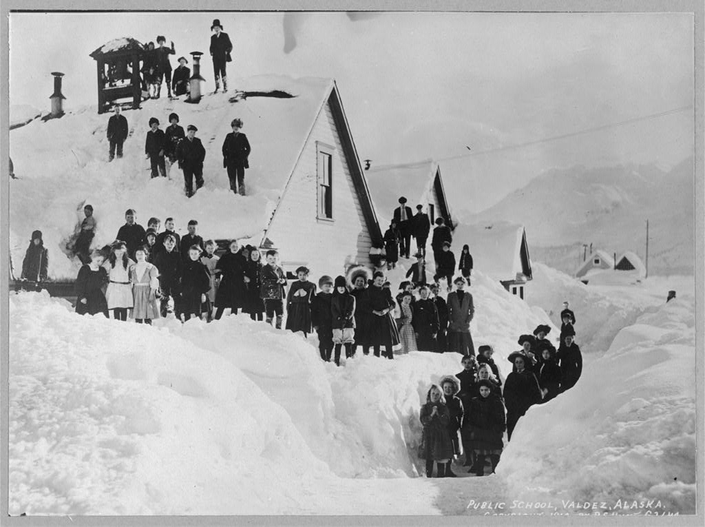
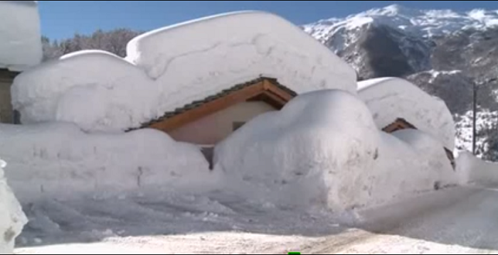
Massive snowfalls are not only found in the mountains of the Pacific Northwest. The coastal town of Valdez, Alaska sees an average of 320 inches, and that is at sea level!
The winter of 1989-90 is in the record books as Valdez’s snowiest winter ever, with a total of 560.7 inches (46 feet) of snowfall. A daily record was set on January 16, 1990 with 45.7 inches of snowfall in just 24 hours. The following day, another snow depth record of 63 inches was set in this coastal town. An average of 2.6 inches fell every hour; that much snow would cover 4 story buildings, houses, and cars .


The Sierra’s and Rockies have had their share of “Big Dumps” to be sure. Silver Lake, Colorado saw 76 inches of snow in a 24 hour period. But the storm did not stop after 24 hours. When it all ended 32.5 hours later, 95 inches lay on the ground. That is an average of 2.9 inches an hour.

In the Sierra’s of California, known for big storms that roll in off of the Pacific, 67 inches of snow fell on January 4, 1982. A single storm snowfall, also in 1982, dropped 186.6 inches on Donner Summit. In fact Donner Pass, has topped 775 inches of snow on four separate occasions. Making it one of the snowiest places in North America.
Top 10 Snowiest Locations in the U.S.A. by Annual Average Snowfall (various periods of record):
680” Paradise Rainier Ranger Station, Washington
552” Thompson Pass, Alaska
530” Mt. Baker Lodge, Washington
530” Crater Lake, Oregon
516” Alta, Utah
471” Soda Springs, California
445” Tamarack, California
442” Stampede Pass, Washington
436” Wolf Creek Pass, Colorado
429” Silver Lake, Brighton, Utah

Japan
If you saw the Sweetgrass film, Signatures, or Japan: A Skiers Journey, then you know about the endless powder runs that this island nation has to offer. It only makes sense that a group of islands in the northern pacific would have the highest yearly snowfalls. The largest annual snow depths in the world have been recorded on the island of Honshu.
Impressive as the depths recorded in North America might seem, the deepest snow on earth accumulates in the Japanese Alps of Honshu Island around the 2,000-6,000 foot level. The average annual snowfall is estimated to be in the 1200 to1500 inches (100 -125 feet) range. This would leave only the last 55 feet of the Leaning Tower of Pisa in the clear. (see The Climate of Japan by E. Fukui p. 171). On February 14, 1927 a snow depth of 465.4 inches was measured on Mt. Ibuki at 5,000 feet elevation. In fact, these amazing snow depths are a singular tourist attraction. A highway that transects the mountains is kept open all winter. It is known as the Yuki-no-Otani Snow Canyon.
Europe
In checking major snowfalls in Europe, there was no lack of nationalism. It seems everyone wanted to point out that their country had more snow than any other. Norway and Sweden seem to lead the pack. The European Alps are no stranger to immense snow events either. A record snowfall of 67.8 inches occurred in Bessans in the French Alps during a 19 hour period between April 5-6, 1959. This amounts to an average of a little more than 3.5 inches an hour. Wow!!
The Western Great Caucus Mountains of Russia near Turkey and the Black Sea also see amazingly high amounts of snow. Achishko (elevation 6,200’) has measured snow depths as high as 315 inches.
Hi! After a bit of a hiatus, I am back to talk about SNOW! Looks like I came back just in time to read a great blog post about snow around the world! 🙂
No major snow in sight. Remember November 2014 when GR got 31″ of snow?
Happy Birthday Slim!! Remember you are only as old as you feel!!
I am up in Bay City for my birthday. The temperature here this AM is 30° there are broken clouds but no frost. I said yesterday I would report on the leaves here as there are still a lot of leaves on the trees in the GR metro area. Well on the trip here it varies going from areas of a lot of leaves with good color to areas of no leaves and a more November like look. Here in Bay City being near the Saginaw Bay there are still a lot of leaves on the trees and some good… Read more »
To day is my Birthday yes I am now 67 years old Oh Boy getting old now. LOL
Slim
Happy birthday Slim! Have a awesome day!!
HAPPY BIRTHDAY SLIM!!! HAVE A GREAT DAY!
Happy birthday Slim – enjoy the day!
Happy Birthday!!! Thanks for all your weather knowledge you share with us!!! Have a Great Day!!!
Happy B-Day, Slim! I hope you had a great day.