We lost a lot of snow cover yesterday and overnight. Yesterday’s high was 48° and the low was 31°. We have had .68 of an inch of rain so far today (this is the digital reading, not the ‘official’ analog reading).
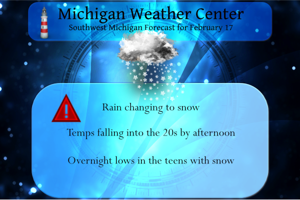
We have multiple hazards for today.
...FLOOD ADVISORY IN EFFECT UNTIL 430 PM EST THURSDAY...

* WHAT...Flooding caused by rain and/or snowmelt is expected.

* WHERE...A portion of southwest Michigan, including the following
  counties, Allegan, Barry, Kalamazoo, Kent, Ottawa and Van Buren.

* WHEN...Until 430 PM EST Thursday.
...WINTER WEATHER ADVISORY REMAINS IN EFFECT UNTIL 1 AM EST
FRIDAY...

* WHAT...Snow expected. Total snow accumulations of 2 to 4
  inches.

* WHERE...Barry, Eaton, Kalamazoo, Van Buren and Ingham counties.

* WHEN...Until 1 AM EST Friday.
...WINTER STORM WARNING REMAINS IN EFFECT FROM 3 PM THIS
AFTERNOON TO 3 AM EST FRIDAY...

* WHAT...Snow and mixed precipitation expected. Total snow
  accumulations of 4 to 8 inches and ice accumulations of up to a
  glaze near the Ohio border.

* WHERE...Livingston, Macomb, Washtenaw, St. Clair, Lenawee,
  Monroe, Oakland and Wayne Counties.

* WHEN...From 3 PM this afternoon to 3 AM EST Friday.
...WINTER WEATHER ADVISORY IN EFFECT UNTIL NOON EST TODAY...

* WHAT...Flash or near-flash freeze this morning.

* WHERE...Midland, Bay, Huron, Saginaw and Tuscola Counties.

* WHEN...Until noon EST today.
This hazardous weather outlook is for portions of southwest Lower
Michigan.

.DAY ONE...Today and Tonight

Any wet roads first thing this morning will have the potential to
become icy as temperatures fall below freezing through early this
afternoon.

Accumulating snow can be expected for most of the area through
tonight. Amounts will range from an inch or less along the U.S.-10
corridor, to 4 to 7 inches toward Marshall and Jackson. Snow
covered and slick roads will create some hazardous driving
conditions, especially for southern areas.
Forecast Discussion
- No changes to the headlines and forecast for the current system

Consensus of the latest model data from the 00z runs indicate that
our going forecast is largely on track, and we will not be making
any changes to the winter headlines for now.

The heaviest rain has mostly moved through the area now, with one
more batch over the SE corner of the area still as of 08z this
morning. This batch of rain looks to be immediately ahead of the
cold front which is just west of a LAN to AZO line. Precipitation
has changed over to snow across our NW counties where the colder air
has become sufficient up there to change it over.

The residual rain will see a transition over to mainly snow for most
of the area before it tapers off temporarily later this morning. It
seems that a significant amount of freezing rain is generally not
expected, as sfc temps will likely stay above freezing until after
the changeover to snow. We could see some slick roads develop also
as wet pavement may freeze as temps drop below freezing. This will
likely happen for most of the higher populated areas, which saw the
higher amounts of rain, after the morning rush. Roads are still a
bit warm from the 40-50 degrees and rain, so it will take a little
bit of time. We will handle that with a Special Weather Statement to
garner some attention. If it gets bad enough, we can always issue an
advisory.

The caveat to this is further south. As the pcpn tries to change
over there, we will lose mid level moisture with this first batch
and the dgz will become unsaturated for a few hours. This will
likely lead to some drizzle, which will likely be of the freezing
variety as temps drop below freezing. The area expected to be most
affected is already in headlines, and we will communicate that
hazard through that.

We will see pcpn expand in coverage then this afternoon as we see
the next wave ride up along the cold front. The pcpn should change
over to snow for all areas as the dgz becomes saturated once again,
and the colder air makes it through the area. Models are in good
agreement finally on amounts, which match up well with our existing
headlines. The highest amounts are expected for Calhoun and Jackson
counties, where the warning is.

- Light snow amounts still expected for late Fri-early Sat

The system for Friday night looks very similar to previous runs. It
looks like an inch or so of snow for much of the area, with maybe 1-
3 up north. Again, the bulk of this system will be north of the
area. What it looks like we will see will be a band of snow showers
ahead of the incoming upper wave. These could be briefly moderate in
nature, but the key word is brief. The impacts will be limited also
with this coming in centered around Friday night.

We still think that there could be a brief period of lake effect
late Friday night and early Saturday morning when the upper trough
is overhead. Ridging builds in very quickly on Saturday, helping to
taper snow showers off quickly.

- Continuing to watch a potentially messy and impactful system next
Tuesday

The period from late Saturday through the day on Monday should be
quiet. The upper jet will move far enough north to keep embedded
short waves away from the area.

We are still looking for a cold front to slowly slide down through
the area by Monday night. This will have little to no pcpn with it
by itself. It will become active as we see short wave activity ride
along the front, and draw a good amount of warm and moist air
northward over the front.

This is a fairly textbook wintry mix scenario setting up, of which
the models have been fairly consistent. The models are showing 850
mb temps around 5C or so over the area, while a low level NE flow
funnels in dry and colder air at the sfc. There are plenty of
details to be worked out with this, this far out. The message is
though that we are looking at some potentially impactful weather
centered on Tuesday.
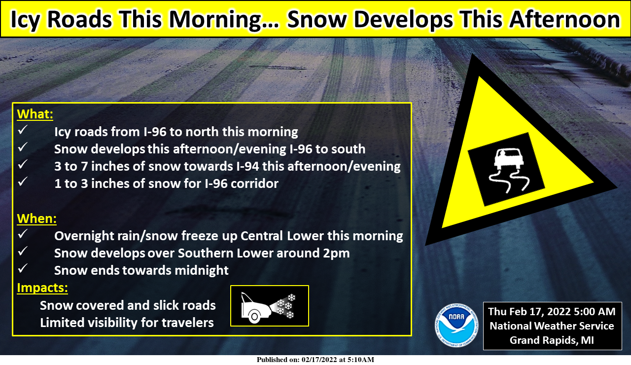
There is potential for icy roads developing from I-96 to the north this morning as overnight rain and snow freezes up. Backroads will be especially vulnerable if packed snow remains from the last few weeks. Otherwise, snow will develop across Southern Lower Michigan this afternoon and continue through the evening hours. In general 1-3 inches of snow is expected along I-96 and 3-7 inches down along I-94. If travelling today be prepared to encounter slippery road conditions.
Wow, we are back in the deep freeze and more snow tonight, Monday night and beyond! What a winter! The so called big warm up may last a whopping 24 to 36 hours! The CPC says plenty of cold and snow the next two weeks! Who would have thought! This had been and is one of the best winters for outdoor sports in a long time and it just keeps getting better and better! Incredible!
Roads were absolutely terrible when I was driving home from the YMCA at around 8PM. I was not expecting the snow to be so heavy. Like Sandy mentioned below, roads are really slippery!
Yes Winter weather advisory criteria for sure in the GR area ….InDY
Just so happy we’re only getting flurries and a dusting of snow here tonight! So glad the big snow is way to the southeast!
LOL! What a joke of a storm for those more north. We have less than 1″ so far. For hours radar was saying it was snowing, but not a flake was falling. So disappointing.
After being told over over February will be a quiet and warm month well as of February 17th above average snowfall and below normal temps just look outside…InDY ..
Hey if you have to go out on the road please slow down. They are very slippery and snow is coming down fast.
Who would have thought and great advice! It is turning out to be quite a snowy winter!
The above normal snowfall month keeps going and going! Wow!
The great winter news just keeps coming and coming! We are getting pummeled with snow as we speak! Incredible!
Got to get an awful lot of snow the next couple days to get to that 24 inches you predicted on your maps!
Getting moderate snow now at my place. Snow has really picked up just within the last 20 minutes or so. Roads starting to get snow covered.
More great news! The latest CPC shows cold right into March! Let’s keep this rock n roll winter party rolling all the way through March!
19* degree temperature change feels great outside….INDY..
And just think, the warm weather nuts are trying to tell us it is a mild winter and Spring is right around the corner! Total and utter delusion!
Just another above average day. I love it!
The road I live on currently has standing water over the roadway. The snowpack has sadly been obliterated by all the rain. Might squeeze out a couple inches with the next wave
So far we have had 2.98 inches of liquid precip from rain and snow for February. We still have a few inches of snow cover on the ground.
Not sure if anyone follows Judah Cohen, but he’s been talking about a possible PV split around the end of the month. Which is a pretty big reversal from the models just a couple weeks ago when they indicated widespread warmth over the continental US. Now they are showing a pretty massive ridge over Alaska and cold over the Great Lakes… hopefully around the second week of March that ridge moves over here 😀
Judah is one of my Twitter ‘friends’
No, he’s a self proclaimed winter crazy. Always predicts snow and cold.
Despite the warm weather propaganda, we are still above normal for Feb snowfall and well below normal for temps! Incredible!
Great news!!!!!! The latest CPC shows cold and snow for us next week! The ground is still frozen solid, so bring on the accumulating snow and cold! What a great year for outdoor winter sports! Fantastic!!!! !
Wow, is that you admitting you’ve been dead wrong the past week? LOL
Lol you are totally crazy and off your rocker!
Rocky (Rockford)
>>>>>BREAKING WEATHER BULLETIN>>>>>The 12Z GFS is sticking to its guns and still has GR in the bullseye for HEAVY SNOW! Let’s see if Euro and the RDB jump on board because then we will have the verification we need to declare for a WSW! Stay tuned for later updates and get prepared now!!!!!!
February 14, 2022 12:53 pm
Thanks for proving my point that you are totally nuts!
GR was a mild 44 degrees at midnight, so today will go down as another above average temp day.
Despite all the hype and delusions from the cold weather crazies, we are now well below normal in seasonal snowfall and my yard is virtually snow free, how could that be???
Just the facts! Less than two weeks until spring!
+1000000
BRING IT!!
What a Storm!!! Tons of rain and melting!! Who wouldn’t love warm weather and nice green grass in the middle of February?!?!!
Remember those junk models Rocky posted saying 16″ of snow for GR? LOL
There were a couple from earlier that showed over 20 inches of snow for our area!! More fake news as usual!
Oh, and I MARKED IT DOWN!!
Rocky (Rockford)
Nice 10 day snow map despite the constant warm weather propaganda! How could it be?
https://www.pivotalweather.com/model.php?p=snku_acc&fh=240
February 9, 2022 9:00 pm
Andy W
Cool! I marked down your 24” snow prediction over the next 10 days according to your trusty map! We’ll circle back and review the GRR CF6 on the 19th to see how that pans out!
February 9, 2022 9:31 pm
Wow! The winter crazies are out of control!
Well with the rain (1.15″) here and the warm temperatures and the wind most of the snow is now gone here. There is still all of the snow piles and there is some snow in other places as well but a lot of ground is now showing. The high here was 48 and with cloudy skies it is now 31. As for todays snow? Maybe a inch or two? at most.
Slim
The ‘official’ rainfall total from this system is 1.48 inches
My question is, will the snow be of the heavy, wet type? I hope not.
A big daddy of a rainstorm and warmth in the middle of February! What could be better?
Well that was a lot of rain! 1.27” of it. No snow left in the yard but almost a third of it is now underwater. 50 degrees with a pile of rain makes for a very quick snowmelt. What a snowstorm?
NWS says 2-4 for us. Blake said 3-6. We shall see.
Lots of standing water all around. Our sump pump goes off every half hour or so.
We happily live on a hill with good drainage
👍