We have a hodgepodge of watches and advisories to sort out this morning as the NWS tries to bring the current approaching storm into focus.
At this time a winter storm watch will begin at 10 am tomorrow for areas south of a line from South Haven to Lansing which include Eaton, Ingham, Van Buren, Kalamazoo, Calhoun, and Jackson counties. Snow is expected with a chance of some light freezing rain. Total snow accumulations of 3 to 6 inches are likely, with greater than 6 inches possible. Ice accumulations of a light glaze are possible.
We have a wind advisory for Gratiot, Ionia, Clinton, Allegan, Barry, Eaton, Ingham, Van Buren, Kalamazoo, Calhoun, and Jackson counties which begins at 10 am this morning to 7 pm tonight. Southwest winds 20 to 25 mph with gusts up to 45 mph are expected.
Looking at SE Michigan we have a winter storm watch for Sanilac, Genesee, Lapeer, St. Clair, Livingston, Oakland, Macomb, Washtenaw, Wayne, Lenawee, Monroe counties for three to six inches of wet heavy snow.
We also have a flood watch for St. Clair, Oakland, Macomb, Washtenaw, Wayne, Lenawee, and Monroe counties.
This is the Weather Prediction Centers discussion:
...Heavy snow possible across parts of the central High Plains today...

...Potential for a swath of disruptive snow and freezing rain to extend
from northern Oklahoma to southern Michigan on Thursday...

...Severe thunderstorms possible from the Southern Plains to the Mid-South
beginning Wednesday night, while heavy rain may lead to isolated flash
flooding throughout the Mid-Mississippi/Ohio Valleys and Southern
Appalachians...
On the cold side of the system, a swath of potentially heavy snow is
possible from northern Oklahoma to southern Michigan on Thursday, with
wintry weather also clipping the northern tip of Maine by Friday morning.
The location of the heaviest snowfall remains uncertain, but areas that do
see an extended period of heavy snow could experience snowfall rates over
2 inches per hour at times. Gusty winds will also accompany this system,
which will combine with snowfall to severely reduce visibility. A wintry
mix, including areas of sleet and freezing rain, will likely fall just to
the south of the heaviest axis of snow. Winter Storms Watches are in
effect for the locations most likely to see significant snowfall or a
combination of snow and a wintry mix. This includes far northern Oklahoma,
eastern Kansas, northern-central Missouri, north-central Illinois,
northern Indiana, and southern Michigan.
This storm has left the NWS scratching their head and pulling out handfuls of hair trying to track and anticipate what it is going to do. There still could be some adjustments to the track so we will have to wait for further forecasts as the day goes by.
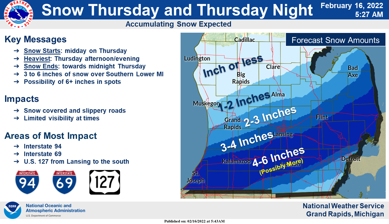
Snow is expected to break out around midday on Thursday and continue into the evening hours before ending around midnight. 4 to 6 inches of snow is expected in a swath across Southern Lower Michigan including Kalamazoo, Battle Creek, Jackson, and Mason. Snow-covered and slippery roads are expected along with limited visibility at times. The Thursday evening commute will be the most impacted. Blowing and drifting snow is also forecast.
Forecast Discussion
- Winter Storm Watch issued for South Haven to Lansing line and
south for Thu and Thu night
- Wind Advisory issued for the SE portion of the area for today

After collaboration with our neighboring offices, we have decided to
issue a Wind Advisory today for our SE areas, and a Winter Storm
Watch for the I-94 counties along with Eaton and Ingham from Thu
morning into Thursday night.

A ripping low level jet of almost 70 knots is already overhead this
morning, ahead of the incoming system. Thankfully this is staying
aloft, with wind gusts of only 20-25 knots having been observed this
morning. Some of the wind aloft will try to mix down during the
daylight hours today. This pattern is not one conducive to mixing
down a lot of wind with it being warm air advection creating
somewhat stable low levels.

That said, that much wind to start off with aloft will allow for
windy conditions today, even with much of it stay aloft. The highest
winds will be over the SE where the axis of the low level jet will
be the highest. Models range from around 35-40 mph, to as high as 55
mph or so. We believe given the warm air advection pattern, and the
fact that the models showing the higher wind speeds say it should be
gusting 40 mph already, we tend to think it will be on the lower end
and it will be a marginal advisory.

The wind will be it for the first part of the day, until rain starts
to develop this afternoon out ahead of the incoming cold front from
the WNW. It will be all rain for the CWFA until later this evening
as enough cold air starts to move in from the NW to start changing
the rain over to snow before pcpn tapers off temporarily. There
could be just a little light wintry mix of freezing rain or sleet
with the transition as the cold air undercuts the rain and warmer
air aloft for a brief time, before the cold air is deeper. Snow and
freezing rain amounts will be on the light side through tonight.

We will likely see a break in the pcpn, before the next round moves
in late Thursday morning, and lasts into Thursday night. The cold
air will be mostly entrenched by the time the next round moves in.
This should allow for most of the pcpn to be snow for our area.
There is a small chance that a little freezing rain would be
possible at the onset Thu toward Jackson, before it would go to all
snow there.

As for amounts on Thu with the watch, the general consensus is that
the highest amounts should generally be around 3-6 inches in the
watch area. The euro and its ensemble mean have been fairly
consistent for a couple of full days now in showing this. The other
international models have been showing this also, with the GFS and
NAM definitely trending toward this solution. There still remains
some potential for 6+" in this area. In collaboration with the
surrounding neighboring offices, it was thought it would be best to
issue the watch to address this possibility for the time being. Our
instinct is that this will end up being a high end advisory for the
watch area.

- Glancing blow from clipper system Friday night

After a brief break on Friday in the wake of the incoming system,
the next system will be coming in centered around Friday night.

The models have remained fairly consistent with this system, in
taking the low across Lake Superior. It does look like everyone will
see at least a little bit of snow with this system as the wave moves
right through the area. It does seem at this point amounts should
not be significant. The lake may add some brief enhancement to the
NW counties with a SW flow and marginal over lake instability. The
pattern does not support heavy lake enhancement as the deep
instability with the cold pool aloft really does not get here with
the polar jet almost overhead. Also, this system will be moving
through very fast, limiting the window of opportunity.

We may see some light lake effect linger along the coast for the
first half of Saturday. 850 mb temps drop down into the negative mid
teens C. Ridging will be building in quick, and squash the
snow showers as inversion heights sink quickly.

- Another possible wintry system Tuesday

Once the lake effect drops off Saturday, we should remain largely
dry through much of Monday. The ridge builds in, and the jet stream
and short wave activity will move well north of the area. SW flow
will help to advect warmer air back in after the quick shot of cold
air for Fri/Sat.

Eventually the jet will migrate south as we head into Monday. This
will slowly push a nearly stationary front down into the area. This
front will initially not really have any impacts with it, so we
should stay dry through Monday.

What will eventually happen is we will see a stronger wave embedded
in the jet ride along this front. This will absorb Gulf moisture,
and make the front much more active. The front and wave look to be
south of the state, but will be close enough that we could see pcpn
on the northern periphery. A lot of details have to be worked out a
week out from this system. Would could see a wintry mix of freezing
rain or snow with this.
It took the GFS and the NAM model about 5 days to catch up to the EURO model on the snowfall track and totals! The GFS is worthless up until about a day before the storm and the EURO can be a tool that will give you a better idea on the expected storm track! Keep in mind that NAM stands for Never Accurate Model!
Reached 51 today. Had a foot of snow on the ground a week ago. Now we have bare spots in the yard.
It was a great day. Warm and not a ton of rain. I am sad to see the snow go! The storm on Feb 2 was the best in years.
…WINTER WEATHER ADVISORY IN EFFECT FROM 6 AM THURSDAY TO 1 AM
EST FRIDAY…
* WHAT…Snow and mixed precipitation expected. Total snow
accumulations of 2 to 4 inches.
* WHERE…Barry county.
* WHEN…From 6 AM Thursday to 1 AM EST Friday.
…WINTER STORM WARNING IN EFFECT FROM 6 AM THURSDAY TO 1 AM EST
FRIDAY…
* WHAT…Heavy snow expected. Total snow accumulations of 4 to 6
inches Thursday afternoon and evening after a period of sleet,
snow and freezing rain early in the morning.
* WHERE…Calhoun and Jackson counties.
* WHEN…From 6 AM Thursday to 1 AM EST Friday.
I reached out to the CMU meteorology program (I am a professor at the medical school) and asked for Mt. Pleasant’s season average and totals. They said Mt Pleasant averages 41″ a year and by mid February usually has 29-30″. This year Mt. Pleasant has received Just 19″, or about 60% of normal. As for temperature, December was 3.6F above average and January was 4.2F below average. Central Michigan needs snow! These storms keep heading south.
Yes it has not been a very snowy winter for areas north and northeast of Grand Rapids outside of the snow belt regions. Been out of the storm track so far.
I’m seeing plenty of 50’s in Lower Michigan right now!
Still no snow watches for GR – wow, what a miss!
WOOD now has 4 days in their 8-day forecast between 40-50 degrees. I love it!
Nice thing if you like Winter and snow we have 3 more systems after this one comeing to west Michigan with more snow keep the plows on the trucks …InDY
Temperatures rose all night long the low here was early last night at 24 and at this time it is cloudy and 47 here. The warm temperatures and rain will do a good job of melting the snow that is now on the ground.
Slim
45 and windy here this morning. I’m seeing 40+ mph gusts around the area already.
It always seems to be windy on recycle day. I’m seeing cardboard tumbleweeds blowing down the street.
Despite all the hype from a few on here, I woke up to 40’s and and snow melting and another storm miss for GR. What could be better?
Let it melt and let the snow deficit continue to grow!
Lol you’re meeting snow since January hasn’t happened yet going on 60 days now with snow covered grounds who knew?? Indy
Hey, if you like a small amount of old crusty snow around, then no judgement from me LOL Hope you enjoyed it!
The average snow depth at Grand Rapids for January and the first half of February has been just over 5″ and there has been at least 1″ of snow cover since December 27th.
Slim
Yes amazing run we have going with snow on the ground matter of fact 93% of the state of Michigan is covered wirh snow ..Not bad for mid February hu Slim ..InDY…
The GFS is taking a more nothern track thats good for west Michigan I am going with 3-6 inches of snow for GR with possible 8 inches in some places middle of February and we have another Winterstorm coming..Woo woo!!! InDY
You said you’re north of GR. You will be lucky to get an inch or two according to NWS LOL
1 inch 2 inch 3 inch just keeps us above average snowfall for the season for the winter that wasn’t….InDY
And just where do you live Mookie?
Slim
Good catch Slim again …He could live in Detroit lol…InDY
Yesterday’s high temp was 32 the low was 17. We are currently at 45 degrees…
So in other words, yesterday was another below normal temp day in West MI!
Let’s rate the models! The GFS and NAM = one step above worthless! The EURO = Fairly consistent and gives you a good trend a few days out! The GFS and NAM have been horrible most of the year! I may need to develop an accurate mid range RDB model to go along with the highly accurate short range RDB! At any rate Winter ROCKS!!!