Light snow moved into the area yesterday afternoon into the evening bringing us 2.5 inches. We now have 20.3 inches for February and 51.3 inches for the season. Yesterday’s high was 43° and the low 19°.
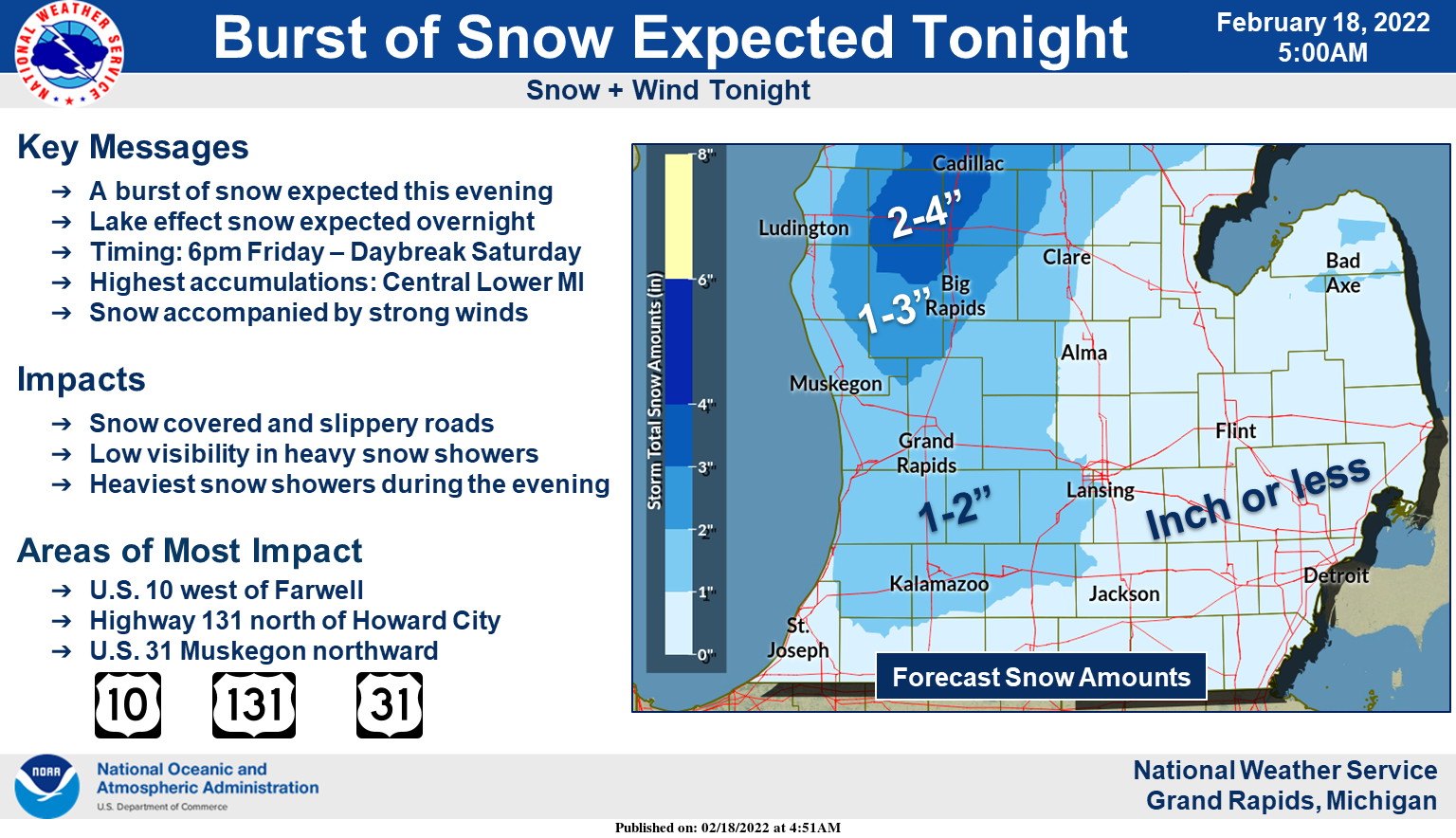
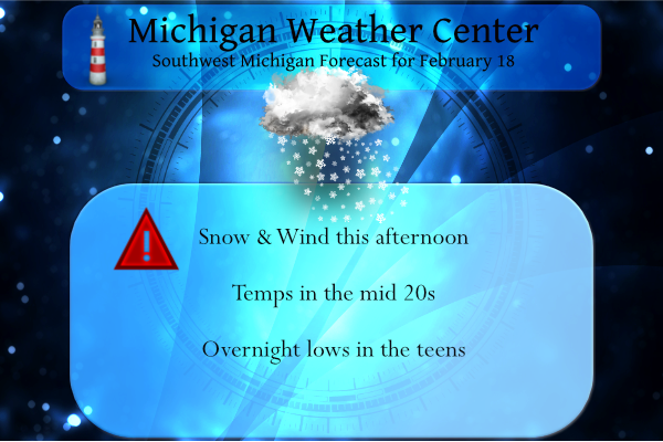
A burst of snow will move through Southwest Lower Michigan after 600pm this evening (Friday). The heaviest snow will occur across Central Lower Michigan near U.S. 10. 2 to 4 inches of snow is possible there by daybreak Saturday. Elsewhere 2 inches or less should fall. The snow will be accompanied by strong winds tonight with gusts above 45 mph. Use caution if travelling tonight due to the snow and wind.
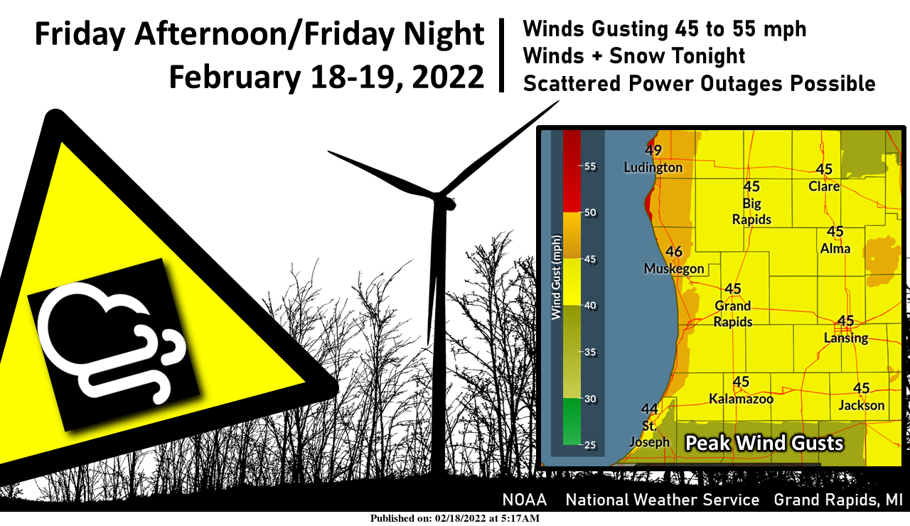
Southwest winds will ramp up this afternoon and reaching a peak this evening. 20-30 mph sustained winds will gust at times to 45 to 55 mph. The highest winds will be found along the Lake Michigan shoreline. Winds overnight will shift to the west and northwest. Scattered power outages will certainly be possible especially in the lakeshore counties. A burst of snow will also be moving through this evening with accumulating snow in much of the area. Highest snow totals across Central Lower Michigan. If travelling tonight be prepared for both wind and snow.
We once again have some advisories to deal with day:
...WINTER WEATHER ADVISORY IN EFFECT FROM 1 PM THIS AFTERNOON TO
10 AM EST SATURDAY...

* WHAT...Snow expected. Total snow accumulations of 2 to 4 inches.
  Winds will gust as high as 50 mph in inland locations, and to 55
  mph near the lakeshore.

* WHERE...Portions of central and west central Michigan.

* WHEN...From 1 PM this afternoon to 10 AM EST Saturday.
...WIND ADVISORY IN EFFECT FROM 1 PM THIS AFTERNOON TO 10 AM EST
SATURDAY...

* WHAT...Southwest winds will increase to 20 to 30 mph this
  afternoon with gusts to around 50 mph expected. Winds will shift
  to the northwest during the evening with wind gust potential
  remaining around 50 mph through the night. Snow showers are also
  expected from this evening through the overnight. A quick inch
  or two of snow is possible tonight.

* WHERE...Ottawa, Allegan and Van Buren counties.

* WHEN...From 1 PM this afternoon to 10 AM EST Saturday.
Weather History for SW Michigan
February 13
1938: Heavy rain and warm temperatures prevail for the second day. Lansing records over three inches of rain from the storm and Grand Rapids over two inches and some minor flooding is noted across Lower Michigan.
February 14
1899: The record arctic cold wave begins to abate but not before Grand Rapids sets their all-time record low of 24 below zero.
February 15
1954: A two-day surge of warm air into Lower Michigan peaks with record highs of 61 degrees at Grand Rapids and 60 at Lansing.
February 16
1981: Lower Michigan is in the midst of a long period of thawing weather with lows above freezing and highs mostly in the 50s from the 16th to the 20th.
February 17
1973: Arctic air is in force across Lower Michigan with record lows of 19 below at Grand Rapids. Muskegon falls to 14 below zero, just shy of the record low for the day of 15 below set in 1904.
1979: A long spell of frigid weather during January and February results in Lake Michigan freezing over almost completely for the only time on record.
February 18
1926: A snowstorm drops 5 to 9 inches of snow across southern Lower Michigan. Lansing sets a record snow total for the day of 8.5 inches.
2014: Persistent cold weather and frequent snows during January and February result in a deep snow cover that persists through much of March. At Grand Rapids, the snow depth reaches 24 inches on this date, second only to the record of 25 inches set after the blizzard of late January 1978.
February 19
1978: Record lows of 21 below zero at Lansing and 15 below at Grand Rapids contribute to this being the coldest February on record at Grand Rapids and the coldest of the 20th century at Lansing. The temperature never gets above freezing during the entire month at Lansing.
2016: Winds gusts to 70 mph in Grand Rapids and 66 mph in Jackson as a strong low-pressure center moved across the Great Lakes. Lower Michigan was on the warm side of the storm with record highs around 60 degrees.
Weather History for SE Michigan
February 13
On February 13, 2015, Flint set a daily record low of -8 degrees. This broke the old record of -7 which occurred in both 1970 and 1958.
Also on February 13, 1894, a two-day snowstorm dropped 12.8 inches of snowfall on Detroit
February 14
On February 14, 1905, a very cold Valentine’s Day night was experienced in Detroit, with the temperature plummeting to -15 degrees!
Also on February 14, 2007, a two-day snowstorm ended leaving most of Metro Detroit with 6 to 8 inches of new snow. There was also considerable blowing and drifting of the snow with drifts reported as high as 2 to 4 feet in some locations.
February 15
On February 15, 2015, Amidst an intense cold outbreak during one of the coldest months in the climate record for Southeast Michigan, Detroit, Flint, and Saginaw all recorded daily records for the lowest average temperature of -1, -7, and -5 degrees respectively. In addition, Flint and Saginaw recorded record low high temperatures of 2 degrees to go along with record lows of -17 and -13 degrees respectively.
Also on February 15, 1954, the daytime temperature soared to 66 degrees in Detroit, which is 32 degrees above average!
February 16
On February 16, 2021, a significant winter storm impacted the region with areas along the lakeshore in Sanilac and St. Clair Counties receiving over a foot of snow. The snow was light and fluffy and with northeast winds gusting to 30 mph, there was significant blowing and drifting of snow.
On February 16, 2015, Detroit tied (1904) a new daily record low of -9 degrees under calm winds and clear skies. The temperature in Flint fell to -21 degrees, which tied for the 5th coldest temperature ever recorded in the Flint Area. The previous record for February 16th was from 1963. The NWS office in White Lake reached -23 degrees, a new all-time record low which would ultimately stand for less than a week before being broken again.
Also on February 16, 1875, marks the thirteenth day in a row of overnight low temperatures of 0 degrees or below in southeast Michigan!
February 17
On February 17, 2014, a low-pressure system brought accumulating snowfall that lasted into the morning of the 18th. 3 to 5 inches were measured across the area. However, locations across the north that saw precipitation remain all snow throughout the event recorded higher totals including 8 inches in Port Austin and 6.5 inches in Bay City.
Also on February 17, 1979, the overnight temperature plummeted to -19 degrees in Flint!
February 18
On February 18, 2019, an overachieving snowfall event occurred. A strong upper-level wave led to convective snow that resulted in a narrow swath of 5 to 7 inches of accumulation across the Ann Arbor to Utica corridor. Most other areas saw 1 to 4 inches of snow.
On February 18, 1976, the daytime temperature rose to 62 degrees in Detroit, which is 27 degrees above average!
February 19
On February 19, 1900, a snowstorm dropped 12.6 inches of snow in Detroit. This was the 7th heaviest snowstorm in Detroit history. It also started a remarkable run of snowstorms that included the 3rd and 4th heaviest snowstorms during the next two weeks in 1900.
Forecast Discussion
- Lake-effect snow through morning

Some areas of lake-effect snow are ongoing as of this writing,
mainly affecting areas south of Holland. Expect that this snow
will gradually diminish over the next few hours as inversion
heights lower and the DGZ dries. Aside from this lake-effect snow,
travel impacts from the departing system will likely continue
into mid morning.

- Snow showers and strong winds tonight

A relative lull is expected later this morning as lake-effect snow
diminishes and surface ridge axis propagates eastward through
region. Surface winds will then back/re-strengthen this afternoon in
advance of approaching Clipper low.

Snow showers are expected to redevelop beginning this afternoon
(to be discussed below), but strong winds are the main concern
for this forecast update. Gusts over 45 mph are possible within
the pre-frontal SW flow, but strongest winds appear likeliest
behind the southeastward-advancing cold front overnight. Within
this post-frontal zone, a tight/favorably-oriented isallobaric
gradient and relatively straight streamlines will contribute to
strong sustained wind speeds. Additionally, low-level cold
advection behind the front--maximized above the surface--will
serve to steepen low-level lapse rates despite the time of night,
facilitating deep mixing within the PBL and downward transport of
higher momentum, favoring higher surface gusts. This momentum
transport may be further aided by below-cloud sublimation/downdraft
production within the more robust snow showers tonight.

Based on BUFKIT profiles of recent HRRR and NAMnest guidance,
expect gusts of 45-50 mph for most of forecast area. These gusts will
likely contribute to isolated power outages tonight. For our northern
lakeshore areas (generally Whitehall northward), gusts to 55 mph
are expected, with a risk of scattered power outages.

Regarding snowfall, expect snow to redevelop generally after 2 PM
for our forecast area, initially across our northern counties, then
expanding SE. The fast movement of this system will limit precip
duration and overall snowfall amounts, with generally 1-4 inches
expected within the Winter Weather Advisory area. Nevertheless, some
brief heavy bursts of snow are possible within this area, where
BUFKIT profiles indicate narrow CAPE profiles (~75-100 J/kg) that
may support briefly heavy snowfall rates. These rates, in
conjunction with strong winds, will likely result in briefly reduced
visibilities below 1/2 mile in the heaviest snow showers.

- Snow showers diminish Sat morning, then a dry weekend

Expect lake-effect snow showers to wane in coverage/intensity
through Sat morning as convective mixed layer becomes shallower
beneath persistent subsidence. Much of Sat will feel brisk, but
some inland locales may see some sunshine by afternoon. Low-
level warm advection commences on Sat night, with much warmer
highs expected on Sun.

- Active weather next week

A seasonably active late-winter regime is expected next week. A
strong (210+ kt) NW Pacific jet will begin an eastward extension
early in the week, with its exit region reaching the dateline by
00z Tue. Downstream of this exit region, a highly amplified upper
ridge is expected to become re-established over the Gulf of
Alaska, with a deep western CONUS trof developing on Mon.
Meanwhile, very cold surface air will surge southward along the
lee of the Rockies and into the northern plains on Mon/Tue. As a
result of these developments, a tight baroclinic zone is expected
to become established by Mon night, extending from the high plains
to the Great Lakes. Along the warm side of this baroclinic zone,
anomalously high precipitable water will again be present. This
baroclinic zone, in conjunction with separate polar and
subtropical jets, will be key in the development two synoptic
disturbances to be monitored through next Thu. The first system
will likely impact our area between Mon night and late Tue night.
GFS and ECMWF forecast profiles continue to suggest the
possibility of mixed precipitation types across our forecast
area, to include sleet and freezing rain. The second system may
approach for Thu, but considerable uncertainty exists regarding
the track of this system, with numerous EPS ensemble members
keeping this system well SE of our area.
We have lightning showing up on radar now in Benzie County, MI near Crystal Lake
Anyone see all the thundersnow that is occurring on the other side of the lake? That is incredible! Update from the NWS in Grand Rapids: “More of curiosity than anything but over the past hour there is a line of THUNDERSTORMS from near Sheboygan WI to near Mason WI. The Hi Res models actually show the low level instability increasing as that line moves on shore over our western CWA around 10 pm this evening. At this point I do not plan on putting them in our actual gridded forecast but what that does mean is the idea of intense… Read more »
RDB model update>>>>>get ready GR for 1 or 3 inches of snow tonight into Saturday! Incredible winter!
Things will get nasty if we get that combined with the strong winds. Already getting blowing snow here going over the roads
Low visibilities and slippery roads tonight! Be careful everyone!
For a quiet February the winds blowing its freezing and more snow on the way…Who Knew …InDzy
Facts! Above normal snowfall and below normal temps in January and now in February! Incredible winter so far! I absolutely love it!
Who loves winter? I could take about 8 or 9 months of this cold and snow! Heaven on Earth baby!
Not related to current weather , but I took a drive the other day to the Lake Odessa area. With all the leaves gone of course you can really see just how many trees were sheared apart in the tornado back on 6/26/21. That was among one of the wildest days of 2021. The house that got blown apart in the tornado is being rebuilt. I was on scene of that damage just after the tornado happened, then proceeded east to Lansing and then to Jackson. I was out storm spotting many tornado warned cells that day. Probably the most… Read more »
Wow another WWA! We have seen a lot of these this winter! The cold and Snow just keeps pounding us with no let up in sight! What a winter!
If we do get wind gusts up towards 50MPH the roads even out in my area are going to be a mess. Roads here can be a mess and drifted over on a sunny, windy day.
Update from NWS Grand Rapids:
“After collaboration with NWS Northern Indiana, we will replace
the wind advisory with a winter weather advisory for Ottawa. Kent,
Allegan, Barry, Van Buren and Kalamazoo Counties for a
combination of snow and blowing snow. Accumulations in some of
these counties will be light…an inch or less across the
southern zones. The issue there is that the southern zones did
get some powdery snow yesterday and the winds should cause enough
blowing snow to create travel problems, especially in open areas.”
I am personally surprised there was not an advisory last evening as the intense band moved through. I think it moved further north than they were expecting. We had a good 2-3 inches here in just a few hours
Yeah I think they mentioned in the discussion update last evening that the track was a touch farther north than expected. It was very quick hitting. I went from nothing to 3.5” in a short amount of time
We received about 2.5 inches last night as well
Wow, we are back in the deep freeze and more snow tonight, Monday night and beyond! What a winter! The so called big warm up may last a whopping 24 to 36 hours! The CPC says plenty of cold and snow the next two weeks! Who would have thought! This had been and is one of the best winters for outdoor sports in a long time and it just keeps getting better and better! Incredible!
42 Sunday, 44 Monday for the long weekend. Another warm up!
Just cleared the neighbor’s driveway since they’re out of town. The sun is warm and doing the trick. The residual snow in our driveway has melted and most of the driveway has dried.
I cleared my driveway this morning and it’s already drying out. The direct sun really goes to work and melts things nicely this time of year.
What wait a minute how come woo DDDDDD the month that was supposed to be quiet and warmer look outside is that more snow and temperatures in the teens ??? Who knew..InDY
Despite all the imaginary snowstorms we were supposed to get, the snow deficit continues and the streak of 1” of snow or more on the ground also died yesterday. I love it!
Well it once again looks like winter outside. While most of the snow that fell yesterday was south and east of here I did pick up 1.6″ of new snow here. Officially GRR reported 2.3″ of snow fall yesterday. At Grand Rapids the total for February is now at 14.8″ and for the season 60.4″ At Lansing they reported 4.3″ of new snow fall and are now at 22.6″ for February and 46.3 for the season. Muskegon is still way below average as they only pick up .9″ of new snow and for February they are only at 8.6″ and… Read more »
Looks like my estimation was pretty accurate. Still amazes me that we’ve had more snow here than Muskegon. Thanks Slim.
And lansing has had 26” more than those just an hour north! Crazy year!
That IS crazy.
Above average snow for GR now way!!! InDy
False. Sorry.
Cleared the driveway so my better half could go to work. Some drifting but I bet we received 4-5”. All schools south and east of the I-69 corridor are closed. Blake nailed this forecast.
Wow! The cold and snow just keeps coming! What a winter and what a 2 month stretch of virtually non stop cold and snow! So much for all the warm weather propaganda! We are headed for a cold and snowy week next week! Get prepared now! Great winter so far and let’s keep it rocking!
I picked up 3.5” of fresh snow last night. It’s been a very snowy February in this area. I’ll be going out to do more shoveling. I see there is a Blizzard Warning for parts of Schoolcraft and Alger Counties in the UP around the Munising area.
Sounds awesome!