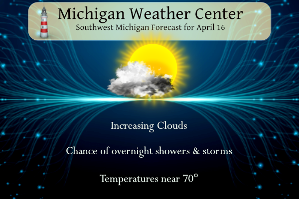
Yesterday we reached 74° for another fine day. We have another in store for today with temperatures trending into the low 70s. The mild pattern will continue through midweek, but a wave of low-pressure moves in for tomorrow. This system will bring showers and thunderstorms. Cooler weather will follow at the end of the week with daytime highs in the 50s.
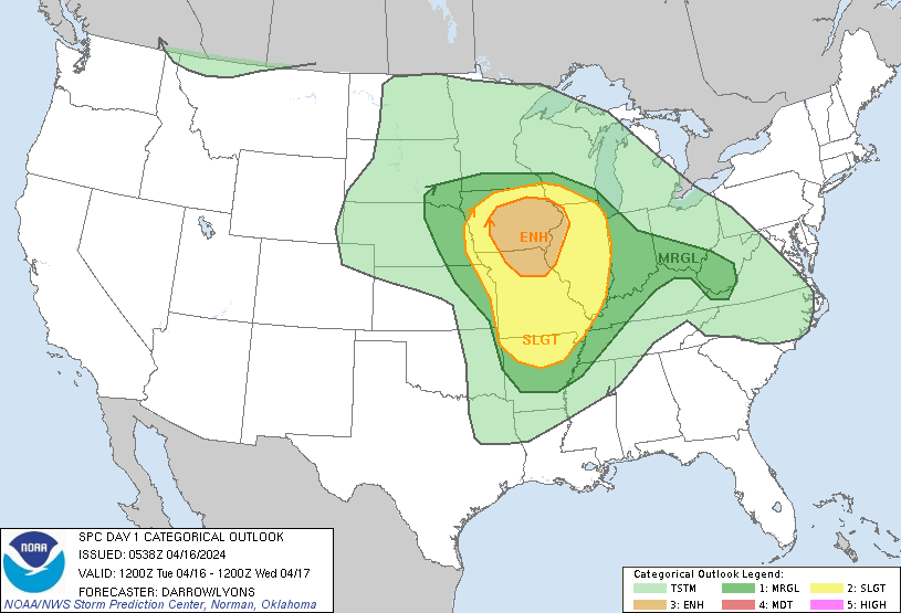
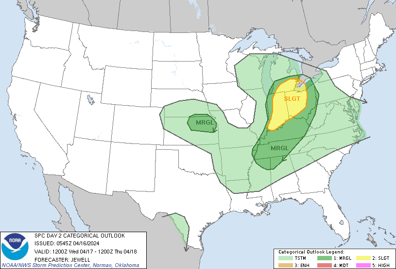
SPC Outlooks
NWS Forecast
Weather History
1961: From 6 to 12 inches of snow falls across southwest Lower Michigan. The storm drops 12.2 inches at Grand Rapids, the heaviest April snowfall on record there.
On April 16th, 2018 Flint exceeded its all-time record snowfall of 83.9″ set in the winter of 2013-2014. A light snow accumulation of 0.2″ put the site at 84.1″ for the season. It would not be the final snow of the year.
Also on April 16, 1992, Wayne County was hit by an F2 tornado at 4:03 PM.
1849: Charleston, South Carolina recorded their latest freeze ever with a temperature of 32 degrees while 6 inches of snow fell at Wilmington, North Carolina. Snow fell as far south as Milledgeville, Georgia. A damaging hard freeze occurred from Texas to Georgia devastating the cotton crop.
1851: “The Lighthouse Storm” of 1851 struck New England on this date. Heavy gales and high seas pounded the coasts of New Hampshire and eastern Massachusetts. The storm arrived at the time of a full moon, and high tide was producing unusually high storm tides. The storm was so named because it destroyed the lighthouse at Cohasset, Massachusetts. Two assistant lighthouse keepers were killed there when the structure was swept away by the storm tide. Click HERE for more information.
2008: Typhoon Neoguri forms over the South China Sea on the 15th and rapidly intensifies to attain typhoon strength by the 16th, reaching its peak intensity on the 18th with maximum sustained winds near 109 mph. More than 120,000 people are evacuated from Hainan when heavy rains cause flash floods in low-lying areas. Three fatalities are attributed to the storm, though 40 fishermen are reported missing. Neoguri made landfall in China earlier than any other tropical cyclone on record, about two weeks before the previous record set by Typhoon Wanda in 1971.
Forecast Discussion
- Sunny this morning, showers/storms tonight

High pressure over northwest Ontario will provide some sunshine
this morning before high clouds move in from the west this
afternoon. Low pressure over the Plains will move east today and
push a warm front in our direction.

There`s a weak signal for a few showers to develop around mid
afternoon over the southwest cwa before diurnal heating wanes and
the showers dissipate.

This system looks like it will produce two distinct precipitation
events. The first unfolds tonight after 03z as the warm front
noses into the region. Expect the usual elevated showers and
scattered storms. Any storms that develop will be aided by a piece
of vorticity that breaks off the main short wave over IA/MN.
MUCAPE around 700 j/kg point toward a thunder potential but not
severe storms. If we do see storms, it will be during round two on Wednesday.

- Strong to severe storms possible Wednesday

The severe threat Wednesday is conditional on how worked over the
atmosphere is from any convection that occurs tonight and the
degree of recovery prior to the cold front moving through
Wednesday. Areas south of I-96 are the most likely to see stronger
storms as dynamics are stronger there.

Bulk shear increases to around 50 kts mid morning Wednesday ahead
of the occluding cold front. SBCAPE around 1000-1500 j/kg and a
mid level wind max nosing in from the southwest will help the
cause for stronger storms. The strong shear points toward the
potential for some organization and bowing segments.

Once the front moves east of the cwa during the late afternoon,
the precipitation will diminish.

- A Period of Rain Thursday Night

As a frontal zone approaches from the west later Thursday, a wave is
shown to develop along it while it tracks into MI.  FGEN in the DGZ
will lead to decent lift while upper level diffluence over the
frontal zones supports deeper lift.  A ridge of higher PWAT values
gets drawn into the front as well, supporting an increased potential
for some rain.  Ensemble QPF trends have been going up, but overall
amounts are looking light, generally under a quarter inch.

- Cooling trend into the weekend

A deepening mid level low in Ontario on Friday, lifts up to Southern
Hudson Bay and into Quebec for Saturday.  Northwest winds are shown
to exist westward through the Canadian Prairies which will act to
funnel the cooler air down into MI through the weekend.  Ensemble
temperature trends are lower so a chilly weekend is looking more
likely with time.  An increased potential for near or below freezing
overnight lows is looking more likely with time.  As for a warmup
next week, an Alberta Clipper is shown to be dropping down into the
Upper Plains Monday into Tuesday.  Thus we could see temperatures
drop or hold steady into mid week as this system passes by MI.  We
noted that the ensemble temperature trends for next week are lower
for the most part.  That decreases the potential for any significant
warmup.
Funny how some people on here are still talking about SNOW! WOW!
As Nathan said Friday, Saturday cool down, then Sunday near normal. After that right back to beautiful ABOVE NORMAL temps!! Keep em Rockin!!
https://weather.com/weather/tenday/l/52aab230ef88e4f2bb12857231a5dd58392e78a71b90e01d57a11d827658eb55
Yet Another Blowtorch Warning coming up!! Take a look at these pretty colors!
Thanks for showing all those low temps in the 30’s! Facts people!
And also no snow!
I’m going out to mow for the first time of the season. I figured that I had better do it before the rain/thunder comes in overnight and tomorrow.
https://www.mlive.com/weather/2024/04/tornado-risk-has-highest-chance-in-part-of-michigan-wednesday.html
Get ready for multiple days with low temps in the 30’s! Wow!
Trolling
Trollio
Just the facts baby!
The “cool down” is really only 2 days (the weekend of course). Otherwise this is a pretty good pattern for mid-April, no complaints!
Hopefully everyone is enjoying the 70’s, because these will be a thing of the past and not reappearing for weeks! Incredible!
You said no 70’s in sight less than a week ago.
Eh, at this point he’s just trolling because he’s still butt hurt about the 3 week winter we just had and our many, many correct predictions we made about the mild and mostly snowless winter. Don’t even try to bring up hard facts up to point out his many absurdly incorrect predictions, he just ignores you and trolls on. We are truly having a fantastic spring with endless 60’s and 70’s for weeks on end, and to state otherwise is delusional!
76 degrees Sunday, 72 degrees yesterday, and more 70’s today? Wow!