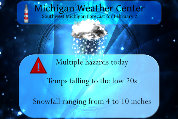
I usually have a weather history post on Wednesdays but with the multiple hazards in place, I will forego that today. We reached 50° yesterday with a low of 26°. We had .50 of an inch of rain (not official) from my digital rain gauge – I will have to melt the precip in my ‘official analog gauge’ this morning. Our temp at midnight was 36°, it has descended to 29° at 4:30 am.
The rain has switched over to snow, so, the fun begins. Here are the current Advisories and Warnings:
...WINTER WEATHER ADVISORY REMAINS IN EFFECT UNTIL 11 PM EST
THURSDAY...

* WHAT...Snow. Total snow accumulations of 4 to 8 inches.

* WHERE...Ionia, Montcalm, Gratiot, Kent, Ottawa and Allegan
  counties.

* WHEN...Until 11 PM EST Thursday.
...WINTER WEATHER ADVISORY REMAINS IN EFFECT UNTIL MIDNIGHT EST
TONIGHT...

* WHAT...Snow. Total snow accumulations of 5 to 7 inches.

* WHERE...Bay, Huron, Saginaw, Midland and Tuscola Counties.

* WHEN...Until midnight EST tonight.
Clinton-Barry-Eaton-Ingham-Van Buren-Kalamazoo-Calhoun-Jackson-...
WINTER STORM WARNING REMAINS IN EFFECT UNTIL 11 PM EST
THURSDAY...

* WHAT...Heavy snow. Total snow accumulations of 8 to 12 inches.

* WHERE...Portions of south central and southwest Michigan.

* WHEN...Until 11 PM EST Thursday.
...WINTER STORM WARNING REMAINS IN EFFECT UNTIL 7 AM EST
THURSDAY...

* WHAT...Heavy snow. Additional snow accumulations of 8 to 10
  inches.

* WHERE...Lapeer, Livingston, Sanilac, Macomb, Shiawassee,
  Genesee, St. Clair and Oakland Counties.

* WHEN...Until 7 AM EST Thursday.
I live in Otsego in the SE corner of Allegan County, our point forecast gives us around 8 inches of snow today while further north the totals decline to 4 or 5 inches in the Grand Rapids area. Kalamazoo is forecasted to have around 10 inches and Lansing 9 inches. I am sure local stations may have different perspectives on snowfall totals, I will leave it to Mother Nature to have the final say in this matter. For those of you keeping track, this is winter storm Landon.
Forecast Discussion
- Snow today for much of forecast area

No changes have been made to winter-weather headlines on this
shift. A well-defined surface cold front is making steady
progress through the region, having now cleared most of Lower
Michigan. This surface front is associated with a tightening
baroclinic zone that extends from the southern plains into the
Great Lakes. Along and south of this front, an anomalously deep
reservoir of water vapor is present, with PW values of 0.7 inches
as close as the MI/IN border. Meanwhile, a 1050-mb anticyclone is
emerging over the Canadian high plains, with steady surface
pressure rises observed across the northern Great Lakes as this
anticyclone begins a southeastward advance. Aloft, two upper-level
jet streaks are noted in GOES water vapor imagery: one over Lake
Superior/Ontario, and a second emerging into the southern plains
in advance of a western CONUS trough. These two jet streaks are
beginning to align into a coupled jet structure, with
recent/gradual cloud-top cooling noted in IR imagery. In the
midlevels, broadly confluent flow from the plains to the Great
Lakes is contributing to frontogenesis along the baroclinic zone.
This frontogenesis, in conjunction with the developing coupled
upper-jet structure and adjacent deep moisture, is producing
extensive precipitation along the baroclinic zone at present, with
mesoscale banding apparent in the regional reflectivity mosaic.

For our forecast area, a general increase in snow
intensity/coverage is anticipated through early morning once the
precip-type changeover to snow is complete. This snowfall will be
sustained by a period of deep-layer ascent arising from the
aforementioned frontogenesis and coupled upper jet structure. For
this reason, precip is expected to exhibit pronounced mesoscale
banding. Across our southern counties, forecast profiles are
statically stable to saturated parcel ascent, but small values of
saturation EPVg (< 1 PVU) within the 700-500-mb layer indicate
weak moist symmetric stability, and may allow for briefly heavier
snowfall rates (> 1 inch/hr) within mesoscale bands forced by
frontogenesis.

Regarding microphysical considerations, BUFKIT HRRR time-height
section at JXN today reveals sustained upward vertical motion
intersecting a somewhat shallow DGZ (only 3-4 kft deep), centered
near 15 kft. Beneath the DGZ, a fairly deep near-isothermal layer
is present for several hours this morning, with temps > -10C. This
layer also intersects a secondary upward-motion maximum within
the profile, suggesting that this layer may foster
riming/accretion of falling dendrites from above, with a
corresponding reduction in SLR. We expect an SLR of around 9:1
later this morning near JXN, which seems appropriate for light
riming conditions. Higher SLRs are expected near JXN thereafter,
increasing to 12:1 by 00z.

Snow will generally wane in coverage tonight as the baroclinic
zone and associated frontogenesis slowly advance southward and
the coupled upper jet structure departs northeastward. However,
some very light additional accumulation is possible in our
southern counties as late as Thu afternoon. Lastly, we will need
to watch for the possibility of lake-effect snow showers reaching
our NW forecast area (near LDM), but significant
accumulations/impacts are not expected from lake-effect snow
tonight.

- Several Clippers, chances for lake-effect snow through Tue

A fairly active northern stream will bring several Clipper-like
disturbances through the region with associated windows for lake-
effect snow. The main timeframes for snowfall appear to be Fri
night into early Sat, then again on Sun into Sun night. We will
carry low PoPs in those periods for now.
Lansing now has more snow than Muskegon this season. And yet, I have only needed to use the shovel and/or snowblower three times.
Lansing received 13.3 inches Wednesday, making it the snowiest February day of all time.
Officially 5.1″ at Grand Rapids. Right in the 4-8 range predicted by the NWS… nice job for such a complex system.
Snow has ended officially. Ended with 10” of snow!
Well, the back edge of the snow is about to arrive at my house. Will post my official storm total shortly. This was an incredible storm for this area
From the NWS:
Some highlights from the storm system today:
Highest reports of 12-13″ – Lansing, Gobles, E of Plainwell
Record snowfall at Lansing of 12.9 inches (and counting)
Record water equivalent at Lansing of 0.81 inches
#wmiwx
Pretty incredible!!
Wow!
This was a powerful storm, despite the hype comments about this was not much of a storm! On the contrary this was record breaker! No matter how big the storm there are always 2 or 3 warm weather nuts that do not face reality! Incredible! What a storm!
+1000000 InDY
Just shy of 12” here and still coming down. All schools closed again tomorrow, but that’s not surprising.
Nice!! Incredible storm. Turned out better at my house than I thought! Still snowing at my house so not measuring until the final flakes move out which should not be to much longer.
I probably got 3-4 inches, but it had that “winter storm feel” outside, if you know what I mean. Areas just to my south and east got it really hard… enjoy!
The texture of snow changed late this afternoon too. We were out plowing and shovelling…it was a bit more icy and about an hour later it wasn’t as icy.
What a storm! GR is closing in on 5 inches! Great call INDY! What a winter!
Yeahh I been tracking this one for days good news we have plenty more snow coming…InDzy
Just hit the 9” mark at my house. Can I squeeze out another inch to get me double digits? If so that would be the first time I’ve seen a double digit snow at MY house since 2017 when I lived in Marne (that was the last year I lived there before I moved east).
Let it snow let it snow let it snow ..InDY
Closing in on 9” at my house. Pretty incredible! Snowing hard again too! Could I squeeze out double digits before all is said and done?
What a storm! Major snows and horrible roads! Great call for Kent and Montcalm to be in a WWA! Incredible storm and still coming down!
Yes, My house has 4-5” now and still coming. Not as impressive as those more southerly, but still a great call to expand the WWA. The roads are absolutely horrendous.
Thanks for the report!m
MV – I like the new title design (not sure the formal name of it).
Still coming down, but only light snow now. Just came in from clearing snow. Took multiple measurements and we received a solid 9”.
I have been working on a new logo for a while, thanks
Still light snow with 23 degrees – up to 7 inches of snow now…
Unrelated news, we have exactly 10 hours of daylight today. 3 weeks we will be at 11 hours. I’ve noticed that when we get to Valentines Day I can typically tell the sun is getting stronger… still pretty weak right now but definitely improving.
New graphic out by WOOD says GR will end up with 2-4″ from this system. More south and east of GR. Less north and west of GR.
Still sitting at one inch total snow accumulation for today in Northern Kent, guess I’ll get the leaf blower out to clear the driveway. Woodtv had it right with the less than 2 inch total in my area! Another laugher of a WWA again!
And the most Accurate model around predicted 2 or 4 inches for Gr! Here in Northern Kent county I picked up 3.5 inches and counting!
No that was WoodTV’s prediction for the area! You said:
Rocky (Rockford)
Very detailed forecast discussion, however for GR get ready for a dud of a storm! Very disappointing set up! The preliminary RDB gives GR a whopping 1 or 3 inches! Better than nothing but a big miss on another big storm!
Reply
February 1, 2022 6:00 am
And here is Wood’s Map from yesterday! Way to go out on a limb for your “prediction” LOL!!!!
You should pay Ellen Bacca for forgery on your “predictions!”
Wood ended up wrong. Too,low!
Wow the snow just keeps coming and coming! What a storm! Even up here in Northern Kent county approaching 4 inches! Incredible!
5 inches in my hood this will put GR above average snowfall for the winter season and its only February incredible..InDY
Great call Indy and as usual the warm weather nuts are saying not much of a storm! What a joke!
My dad told me he measured 9” of snow near Diamondale on the SW side of Lansing
And I’ll add that was a little earlier so likely more than that now
6 inches of of 3 pm – 24 degrees with light snow falling
Heavy snow bands are still rotating through! Wow! Let it snow, let it snow, let it snow!
There are some heavier snow returns coming ashore again as well!
What a storm and the snowfall forecast is right on track for most areas! It is definitely a monster storm! Incredible!
It just keeps snowing! Another WWA and a great snowstorm! Keep it rocking!
Snow coming to an end in my area of northern Kent county. Looking at only about an inch of snow here! Fantastic outcome for me!
No the snow is not coming to an end in Northern Kent county! Here in Rockford we are getting pummeled and have almost 3 inches already! Incredible storm so far with more to come! Fantastic!
Lol! Yeah sure…,
It’s officially the biggest single day snow event at my house since 2018. Just hit 7” so far.
Just cleared the driveway (with a shovel) and I have 2″ of new snow fall. The snow is not real wet so a shovel will do for most. So while not the big storm some were thinking it is still winter out and there is fresh snow on the ground to start the new month. At this time there is light snow falling with a temperature of 28.
Slim
Lunchtime update: 6.5″ on the ground in seven or so hours. Not too shabby.
Blake was just on the noontime news and said we can expect an additional 3-6″.
Much less here at my house with just 2″ of new snow total
Slim
Let it snow let it snow ley it snow…InDT
Closing in on 7” at my house. Currently stand at 6.5”. Looks like this will be the biggest snowfall from one single event since 2018
Yes nice amount I just measured over 3+ inches in my area Im thinking 5 is a good bet for me this will put GR above average snowfall again and its only February woo woo…Indy
NWS Detriot has lowered their snow totals as well. Storm is moving slightly more south and the transition from rain to snow took longer than expected due to yesterday’s warm temps. Looks like the storm is underperforming expectations in Lower Michigan so far.
You are 100% wrong!
NWS GRR just removed a county from their Winter Storm Warning and is now ending Winter Weather Advisory hours earlier. Heavier bands will continue to miss GR to the south and east the rest of the day.
Yes I just was about to mention that. Looks like forecasted snow amount remain the same, but the duration has been cut back.
Lower snow totals so far.
“Snowfall amounts have trended southward with recent model runs”
Looks like the worst is wrapping up for GR… definitely not a 4-8 inch event, maybe closer to 3 for me.
Just clicked up to 5” here at my house. Still heavy snow. Im on track to break my record of 7” from a single storm since moving here from Byron Center in 2018.
I am an hour north of you and we only have 1.5” so far. Relatively narrow band as they predicted.
Yeah, you’re pretty close to Lansing.
We are up to 5″ as well. We had about 3 at 9:30 took a measurement about 11:30 and it was 5.
Yes Nice thats a good snowstorm..Indy
Check out the snow over Ottawa Kent and Ionia county looks to be the heaviest at this moment Who Knew?? InDY
Rocky check it outside moderate snow fallen are we talking about another above chever of a storm Incredible….Let it snow let it snow let it snow …Indy
Check out the United states of America radar this storm drops soiutwest all the way to New Mexico talk about a trainning of snow coming to Michigan GREAT SCOTTY…InDY
Roads are really bad here. We have probably only gotten an inch or two so far, but doesn’t take much to make things slippery.
Just got back from Plainwell, roads are snotty at best. Visibility is a quarter-mile with light to moderate snow falling. We have 3.5 inches of the white stuff so far. Being in the SE corner of Allegan county would put us in warning criteria with around eight inches forecasted, Kalamazoo is forecast about the same, maybe an inch more for them.
I have received 1.5” of snow in about an hours time. Already up to 4” and snowing hard with big flakes. I am making the run for the biggest snowfall since I moved to Portland in 2018. The record highest so far since moving here has been 7” from a single storm.
Yes huge numbers coming in with this storm! It may snow till Friday in some places keep us posted…InDY
Messo out for southwest Michigan for snow rates of a inch or more a hour moving northeast thats pretty attense for the storm that was supposed to miss GR …Current radar shows lots of blue out there shuuu …InDY
Wow 6 more weeks of Winter coming thanks mr.ground hog..What a massive snow storm hitting lower Michigan im calling for 5 to 9 inches for my area remember this is a long duration snowfall that has started it may snow in some areas till Friday…Detroit area may get there biggest 24 hour snowfall event ever of 20 to 25 inches not out of the question other then winds this storm will be bigger then the ground hog day blizzard especially in southeast Michigan…What a snowy start to February…InDzy
Light snow, and tiny flakes/rime(sp?) beginning to increase here in Hamilton. If flake size or rate doesn’t increase, we won’t have much to crow about in my backyard…
Wow snowing very hard now!! The landscape is refreshed after loosing most snow yesterday
Our lawn was green last night. Only piles of snow were left over. Not anymore. Just measured 4″ here.
Nice!! I’m getting snowfall rates a little over an inch per hour. I just measured 2.5” and it’s coming down hard.
I woke up around 4:50 to check radar for MSU, my brother still goes there, and it was the darkest band of blue I have seen.
I recorded 0.16″ of rain yesterday and last night. The high here was 47. The snow depth is now down to around 1.5″ and there are now some bare spots showing in places. At this time there is light snow falling with a current temperature of 27. and there is around 0.2″ of new snow on the ground. I have a feeling that here in the NW side of GR that there may not be more than a inch or so of new snow fall today. For those that like the snow and live to the south or southeast of… Read more »
Wow, it looks like Lansing is getting pounded with heavy snow already. The heaviest bands are going south of GR as expected.
Yep, it’s coming down at a good clip right now. Two, maybe three inches already. It’s pretty heavy, good packing snow.
It is so pretty out. Why couldn’t have this happened on December 23rd??
Yes huge numbers coming in with this storm especially in you’re area Mark stsy safe..InDzy
👍
Snowing moderately at my house currently. 1.5” so far
The latest RDB still gives GR only 2 to 4 inches! Better than nothing.