Yesterday’s “snowstorm” left us with 1.5 inches of the white stuff in Otsego. This gives us a whopping 28.5 inches for the season thus far with two weeks left of meteorological winter.
Light lake-effect snow is expected today through Sunday with notable colder temperatures this weekend. Little or no accumulation is expected. The cold won’t stick around too long as temps warm back well above normal by mid-week next week.
NWS Forecast
Weather History
1981: Lower Michigan is in the midst of a long period of thawing weather with lows above freezing and highs mostly in the 50s from the 16th to the 20th.
On February 16, 2021, a significant winter storm impacted the region with areas along the lakeshore in Sanilac and St. Clair Counties receiving over a foot of snow. The snow was light and fluffy and with northeast winds gusting to 30 mph, there was significant blowing and drifting of snow.
On February 16, 2015, Detroit tied (1904) a new daily record low of -9 degrees under calm winds and clear skies. The temperature in Flint fell to -21 degrees, which tied for the 5th coldest temperature ever recorded in the Flint Area. The previous record for February 16th was from 1963. The NWS office in White Lake reached -23 degrees, a new all-time record low which would ultimately stand for less than a week before being broken again.
Also on February 16, 1875, marks the thirteenth day in a row of overnight low temperatures of 0 degrees or below in southeast Michigan.
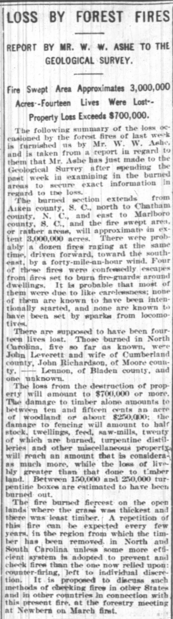
1898: A series of wildfires swept through South Carolina on February 16-17, 1898. Unconfirmed reports indicate that 14 people were killed, numerous homes and sawmills burned, and up to 3,000,000 acres of forest land were charred from Aiken County, S.C. to Chatham County, N.C., and east to Marlboro County, S.C. There were probably a dozen wildfires raging at the same time driven by a 40 mph wind.
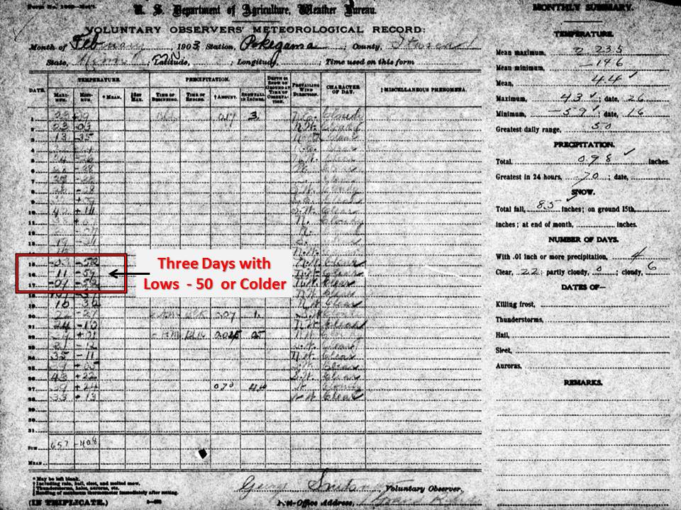
1903: Pokegama Dam, Minnesota saw three straight days with low temperatures 50° below zero or colder, including 59° below zero on the 15th. The minus 59° established a state record for the lowest measured temperature in Minnesota. Pokegama Dam held the record until February 2nd, 1996 when the temperature fell to 60° below zero at Tower.
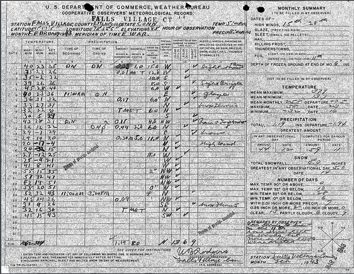
1943: Record cold prevailed in the northeastern United States. The mercury plunged to 37°F below zero at Concord, New Hampshire, and to -39 degrees at Portland, Maine. The morning low of -32°F at Falls Village, Connecticut, established a state record. The Connecticut record low was tied on January 22nd, 1961 when Coventry fell to -32°F.

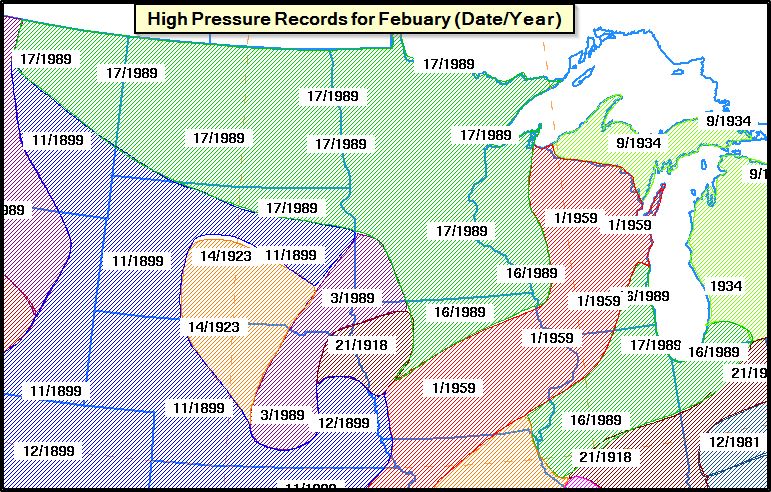
1989: A surge of arctic air on February 16-17 produced all-time record high barometric pressure readings of 31.08 inches at Duluth, Minnesota, 30.97 inches at Chicago, Illinois, and 30.94 inches at South Bend, Indiana. Readings of 31.00 inches at Milwaukee, Wisconsin, and 30.98 inches at Rockford, Illinois, tied their all-time records. Unseasonably warm weather prevailed across the southeastern U.S. Highs of 81 degrees at Athens, Georgia, 87 degrees at Charleston, South Carolina, 85 degrees at Macon, Georgia, and 86 degrees at Savannah, Georgia, were records for February.
Forecast Discussion
- Lake effect snow showers ending then returning tonight

Lake effect snow showers - flurries really - are expected to
gradually dissipate before sunrise. Our next round of
precipitation comes tonight in the form of lake effect snow
(LES) starting after 8 PM. Ahead of an approaching and seasonably
deep clipper type of upper trough, Bufkit soundings predict the
marine boundary layer to deepen up to around 700 mb by early
tonight with convective instability developing in the DGZ.
However, and a little surprisingly, guidance is not overly
impressed with this setup in terms of accumulations and produces
maybe a couple tenths of an inch near the lakeshore by Saturday
morning. Directional shear in the boundary layer suggests we
could see a cellular and disorganized radar presentation of the
LES. This undoubtedly would curtail accumulations in spite of
favorable thermodynamics.

- Roller coaster temps, no major weather systems next week

Some lingering light snow showers or flurries are possible Saturday
night into Sunday but little or no accumulation is expected. Deep
cyclonic flow will be over the region during this time as well as H8
temps still supportive of lake effect. However moisture will be
quite shallow; enough so that some drizzle could occur too due to
the possibility of an unsaturated DGZ.

Surface ridging moves across on Sunday night then southerly flow
arrives Monday on the back side of that ridge. This ushers in a warm-
up with temperatures rebounding back up near 50 degrees by Tuesday
into Wednesday.

Rising PWATs midweek in southerly flow ahead of a cold front
approaching from the northwest leads to our next chance of rain
showers arriving Wed, although precipitation amounts look rather
light at this time. Colder air moves in from the north behind that
front for late in the week, with p-type trending back toward light
snow/flurries by Friday; perhaps as early as Thursday. This too does
not look impressive in terms of amounts given a northerly
anticyclonic flow. High temps behind the front are expected to fall
back into the 30s late in the week.
Skiing here I come! Absolutely perfect winter weekend!
If you like winter and the 1 inch of snow left from yesterday get out and enjoy it, because Spring temps are arriving Monday again and staying for as far as the eye can see! Bring it!!! I love it!!!!!
https://weather.com/weather/tenday/l/52aab230ef88e4f2bb12857231a5dd58392e78a71b90e01d57a11d827658eb55
This mid winter cold is awesome! I love it!
Great weekend for winter sports! Get outside to
enjoy the cold and snow!!!
Side note- today might be the only day this month with a below average low temperature. At least according to AccuWeather
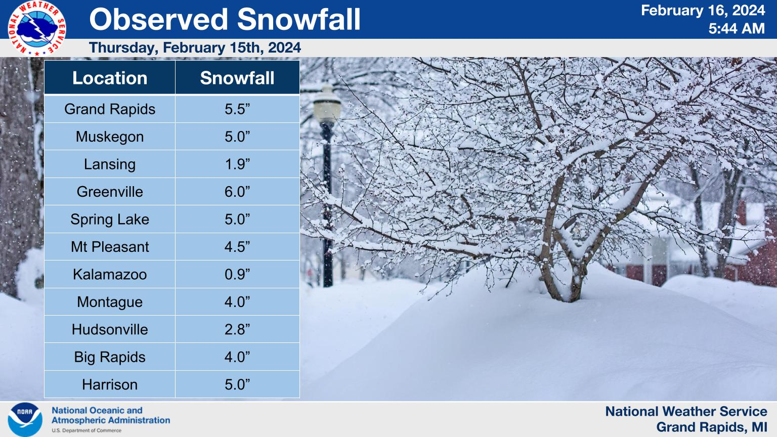
Record breaking precipitation 0.49: and snowfall 5.5” amounts yesterday at Grand Rapids. The official H/L was 36/29 the highest wind speed of 44MPH was out of the west. For today the average H/L is 34/20 the record high of 29 was set in 1921 the record low of -12 was set in 1973. The most rainfall of 1.84” was in 1984 the most snowfall of 3.0” was in 2012. The most on the ground was 23” in 1936. Last year the H/L was 37/22 and there was 1.8” of snowfall.
Slim
What, another record breaking snowstorm! Who would have thought? We are already up to 40 inches of snow with about 6 more weeks of snow chances left this season! Keep the snow rocking!
Yep, that’s only 2 feet below average for this time of year!