So far, the big stories for the winter of 2023/24 have been the mild almost snowless December. The 2 weeks of cold and snow in January saw not only the coldest temperatures of the winter, but a total of 30” of snowfall in just two weeks. And now February has had a very warm start. For the winter season we are running near the record warm meteorological winter of 1921/32. The mean for the meteorological winter of 1931/32 was 33.9 so far this winter has a mean of 33.5.
Here is a month by month breakdown of the meteorological winters of 1931/32 and 2023/24 so far. December 1931 had a mean of 35.8°, the high for the month was 55 and the low was 17. There was 7.1” of snowfall. December 2023 had a mean of 38.3 the high for the month was 58 and the low for the month was 22 there was just 1.3” of total snowfall. January 1932 The mean was 34.2 the high for the month was 58 and the low for the month was 5 there was just 3.2” of snowfall. January 2024 had a mean of 27.1 the high was only 40 the low for the month was -5 There were many days where it did not get below 30. The was a lot of snow in a two-week period when over 30” fell the month ended up with 31.3” of snowfall. February 1932 had a mean of 31.8 the high for the month was 64 and the low for the month was 13. There was 5.2” of snowfall. So far this year the 1st 16 days February mean is 35.1 that is a departure of +10.0. The highest so far is 59 and the lowest so far is just 21. There has been 5.5” of snowfall and 0.53” of total precipitation. In 1932 for the whole month of February the mean at GR was 31.8 the high for the month was 64 and the low for the month was 13. There was 5.2” of snowfall the total precipitation was 1.16”. The next 13 days will decide if this winter will be the warmest meteorological winter.
The official H/L yesterday at Grand Rapids was 29/23 that 29 was the 1st day this month when it has not gotten above 32. There was a trace of snowfall and there was 2” of snow on the ground. The highest wind speed was 27 MPH out of the NW there was just 1% of possible sunshine. For today the average H/L is 34/20 the record high of 55 was set in 1911 and 2011. The record low of -19 was set in 1973. The record high of 55 was set in 1911 and 2011. The record low of -19 was set in 1973. The record rainfall of 0.86” fell in 2008 the most snowfall of 5.6” fell in 2014 the most on the ground was 23” in 1936 in 2014 there was 21” on the ground. Last year the H/L was 27/19 and there was 1.1” of snowfall.
AREA FORECAST DISCUSSION
NATIONAL WEATHER SERVICE GRAND RAPIDS MI
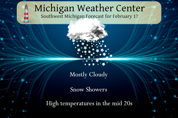
339 AM EST SAT FEB 17 2024
KEY MESSAGES
– LIGHT SNOW SHOWERS AND BREEZY THROUGH SUNDAY
– ABOVE NORMAL TEMPERATURES MOST OF NEXT WEEK
– COLDER AIR AND SNOW SHOWERS RETURN TOWARD END OF NEXT WEEK
DISCUSSION
ISSUED AT 339 AM EST SAT FEB 17 2024
– LIGHT SNOW SHOWERS AND BREEZY THROUGH SUNDAY
SCATTERED MODERATE BURSTS OF SNOW EARLY THIS MORNING PUT DOWN A
QUICK HALF-INCH IN A NUMBER OF SPOTS. MOSTLY LIGHT LAKE-EFFECT SNOW
SHOWERS WILL CONTINUE TODAY, A FEW OF WHICH COULD BE CARRIED FAR
INLAND. THE UPPER-LEVEL TROUGH AND CORE OF COLDEST LOW-LEVEL AIR
WILL BE DEPARTING, SO SNOW SHOWERS WILL GRADUALLY WEAKEN THROUGH THE
DAY.
ANOTHER SHORTWAVE TROUGH AND ASSOCIATED SURFACE LOW WILL GRAZE
NORTHERN MICHIGAN THIS EVENING. THERE MAY BE A BRIEF SNOW SHOWER
AFTER DARK NORTH OF I-96 (MOST LIKELY IN CENTRAL MICHIGAN AND
NORTHWARD) AS MOISTURE AND LIFT INCREASE IN THE MIDLEVELS. FLURRIES
MAY CONTINUE INTO SUNDAY, LIMITED BY SHALLOW INVERSION HEIGHTS
MOSTLY BELOW THE DGZ.
LAKESHORE AREAS MAY RECEIVE 40 MPH GUSTS OFF LAKE MICHIGAN FOR
SEVERAL HOURS LATE THIS EVENING AS A LOW-LEVEL JET PASSES THROUGH
WHILE AIR TEMPERATURES REMAIN COLD ENOUGH FOR THE LAKE TO MIX DOWN
SOME OF THAT MOMENTUM FROM 2000 FEET. INLAND, GUSTS AROUND 25 MPH
ARE EXPECTED WITH DIURNAL MIXING TODAY, AND A STRONG PRESSURE
GRADIENT WILL KEEP A 15-20 MPH BREEZE GOING OVERNIGHT, THEN 30-35
MPH GUSTS ARE LIKELY DURING THE DAY SUNDAY.
– ABOVE NORMAL TEMPERATURES MOST OF NEXT WEEK
EL NINO-ESQUE SPLIT FLOW PATTERN ALOFT PREVAILS AGAIN FOR MUCH OF
NEXT WEEK, WITH MICHIGAN INBETWEEN THE PACIFIC JET STREAM TO THE
SOUTH AND POLAR JET TO THE NORTH. THIS EQUATES TO MORE ABNORMALLY
MILD FEBRUARY WEATHER AND NOT MUCH PRECIPITATION. THERE IS A WEAK
SYSTEM PASSING THROUGH ON WEDNESDAY WHICH COULD PRODUCE A FEW RAIN
SHOWERS BUT QPF IS SHOWN TO BE RATHER LIGHT AT THIS TIME; UNDER ONE
QUARTER INCH.
– COLDER AIR AND SNOW SHOWERS RETURN TOWARD END OF NEXT WEEK
AFTER HIGHS AROUND 50 BOTH TUESDAY AND WEDNESDAY, COLDER AIR RETURNS
TOWARD THE END OF THE WEEK AS THE POLAR JET BRIEFLY DIPS BACK SOUTH
INTO THE GRTLKS RGN. SNOW SHOWERS WILL BE POSSIBLE FRIDAY AND
SATURDAY FROM A SYNOPTIC CLIPPER SYSTEM AND/OR LAKE EFFECT. SNOW
AMOUNTS DO NOT LOOK TOO IMPRESSIVE AT THIS TIME, BUT SOME MINOR
TRAVEL IMPACTS MAY OCCUR AS LIGHT ACCUMS COMBINE WITH LOWS IN THE
20S. (SIMILAR TO WHAT WE ARE SEEING CURRENTLY.)
A tad bit breezy this evening…
What a day! Beautiful scenery out on the trails and great winter temps! I wish we would have 3 or 4 straight months of this!! Wow, wow, WOW!
Roads were in horrible shape in the Detroit metro area this morning from snow showers. I had a pickup truck in front of me spin out go off the highway go airborne and roll 3-4 times on 96 near Howell. I pulled over to check on everyone. One person was stuck inside so I called 911. I stayed till they got the person out. Everyone looks to be ok.
People don’t know how to drive! Slow down and stop tailgating. Wow!
Wow! Single digit wind chills! Instead of whining and complaining about the cold, get outside and enjoy!!!! Incredible!
Another great winter weekend is on tap! Mid winter temps with fresh snow on the ground! Rock n roll will never die! I love it!
We all know there will be an early spring. Punxsutawny Phil told us so. Not to mention, pitches and catchers have already reported for spring training.