
Yesterday we had a very warm 87° and a morning low of 51°. Thunderstorm watches went up in the late afternoon /early evening. We only managed .10 of an inch of rain and a few rumbles of thunder. The rainfall total for the month is 3.03 inches and 10.29 inches thus far for spring.
SPC Forecast For Tonight

A line of severe thunderstorms containing damaging winds could impact the area late tonight. The highest threat (level 3 out of 5) is west of Highway 131 and after 11 PM.
NWS Forecast
Weather History
2001: A swarm of at least 20 tornadoes descend on Lower Michigan. Fortunately, most of the tornadoes were relatively weak, and only five people were injured. Damage included dozens of trees downed, barns blown over and roof and siding damage to several homes. Three homes and a golf course were heavily damaged north of Hartland in Livingston County.
2004: Severe weather causes widespread damage across southern Lower Michigan. Thunderstorm winds up to 70 mph, large hail, and flash flooding occurred as a squall line moved from Benton Harbor to Ann Arbor. Hundreds of trees are knocked down and thousands lose power.
On May 21, 1953, an F4 tornado moved through St. Clair County at 4:21 PM. This tornado is responsible for 2 deaths and 68 injuries. It ties with an F4 tornado that formed June 8, 1953, as the strongest tornado ever to hit St. Clair County.
Also on May 21, 2001, an F2 tornado hit Hartland and dissipated near Fenton. Other weak tornadoes hit Oakland, Lapeer, Shiawasee, and Saginaw Counties.
1881: Clara Barton and a circle of close friends found the American Red Cross. Click HERE for more information from the History Channel.
1949: A violent tornado crossed the Mississippi River from the St. Louis area into Wood River, then to Roxanna. This tornado damaged or destroyed 300 homes in these two towns, killing five people. Four people died in a destroyed restaurant in Palestine, Illinois; one body was recovered from a tree. A tornado causing estimated F4 damage killed five people and injured 55 in St. Louis and St. Charles counties in Missouri and Madison County in Illinois. This tornado was part of an outbreak that produced four different tornadoes and was responsible for five deaths and 57 injuries.
2001: Golfers participating in a golf tournament at the Majestic Golf Course in Hartland, Michigan received an urgent message on the G.P.S. on their carts. The message relayed from the clubhouse, was that a tornado was bearing down on the course. Most of the golfers made it to safety in the clubhouse, although some had to take shelter on the course. Only one golfer suffered a minor injury. The F2 tornado damaged 70 cars in the parking lot along with numerous golf carts and a pontoon boat.
Forecast Discussion
- Severe Storms Possible Late Tonight

A rapidly amplifying shortwave ejects out of the Central Plains into
the Great Lakes this afternoon through late tonight. In response, a
surface low deepens as it moves into northern Wisconsin and the
UP while a trailing cold front becomes the focus for thunderstorm
development. A cluster of storms currently working through
Nebraska and western Iowa will be the focal point to monitor
throughout the day today. Starting off semi-discrete, these storms
will organize and transition into an organized line of storms by
the time they reach central Iowa and western Wisconsin.

Meanwhile across lower Michigan ahead of the storms, return flow
moisture bumps dewpoints into the mid to upper 60s with afternoon
highs peaking in the low to mid 80s. Diurnal cumulus may give way
to a few showers or a stray thunderstorm ahead of the main line
of storms late tonight. Hi-res cams are in good agreement on a
midnight time of arrival of the main line of storms, and are also
favoring a quick weakening trend into lower Michigan given the
late hour and strong nocturnal limiting factors. The progression
of SPC Enhanced in far western Michigan to Slight/Marginal Risk
in central to eastern Michigan nicely depicts the weakening trend
with eastward progression. Damaging wind will be the main hazard
to monitor as the storm mode transitions into a well organized
QLCS to our west and travels east towards lower Michigan.

The eastward advancing cold front will be the focal point for any
additional convection Wednesday, but as the boundary becomes
parallel to the mean flow convection will be very limited and
mainly shunted off to our far southeast. Therefore the risk of
storms has shifted southeastwards.

- Dry for Thursday; Rain Chances Return Friday

Sfc frontal boundary will settle south of MI for Wednesday night
through Thursday night with a sfc high and drier air mass sliding
through, yielding dry conditions during this time.

Current guidance indicates that the boundary lifts back north as a
warm front on Friday afternoon and night as the next shortwave
tracks across the nrn Plains into MN/WI. Pops returning as this
occurs and this is faster than in previous model runs.

- Rain Chances Linger Through the Holiday Weekend

Depending on the timing of the Friday wave, its possible that
Saturday ends up being a mostly dry (and cooler) day due to a period
of subsidence behind it. Confidence is too low at this time though
to advertise a dry start to the weekend and 20-40 pct pops will be
maintained. It is possible that those rain chances end up being
restricted top just the morning-time.

A zonal flow aloft is progged throughout the holiday weekend with
frontal zone/baroclinicity still nearby. This pattern will result in
continued chances of showers and possible storms although the timing
and coverage of convective events remains low confidence. Upshot is
for a continuation of daily 20-40 pops but the weekend will
certainly not be a washout and temperatures will average near to
slightly above normal.
Time always tells…local mets feeling confident this line disappears over the lake. Then again …maybe not ;/
Ready to forecast some storms tonight

That is a great shirt!!!
Nice! I think I just found my Father’s Day gift. 🙂
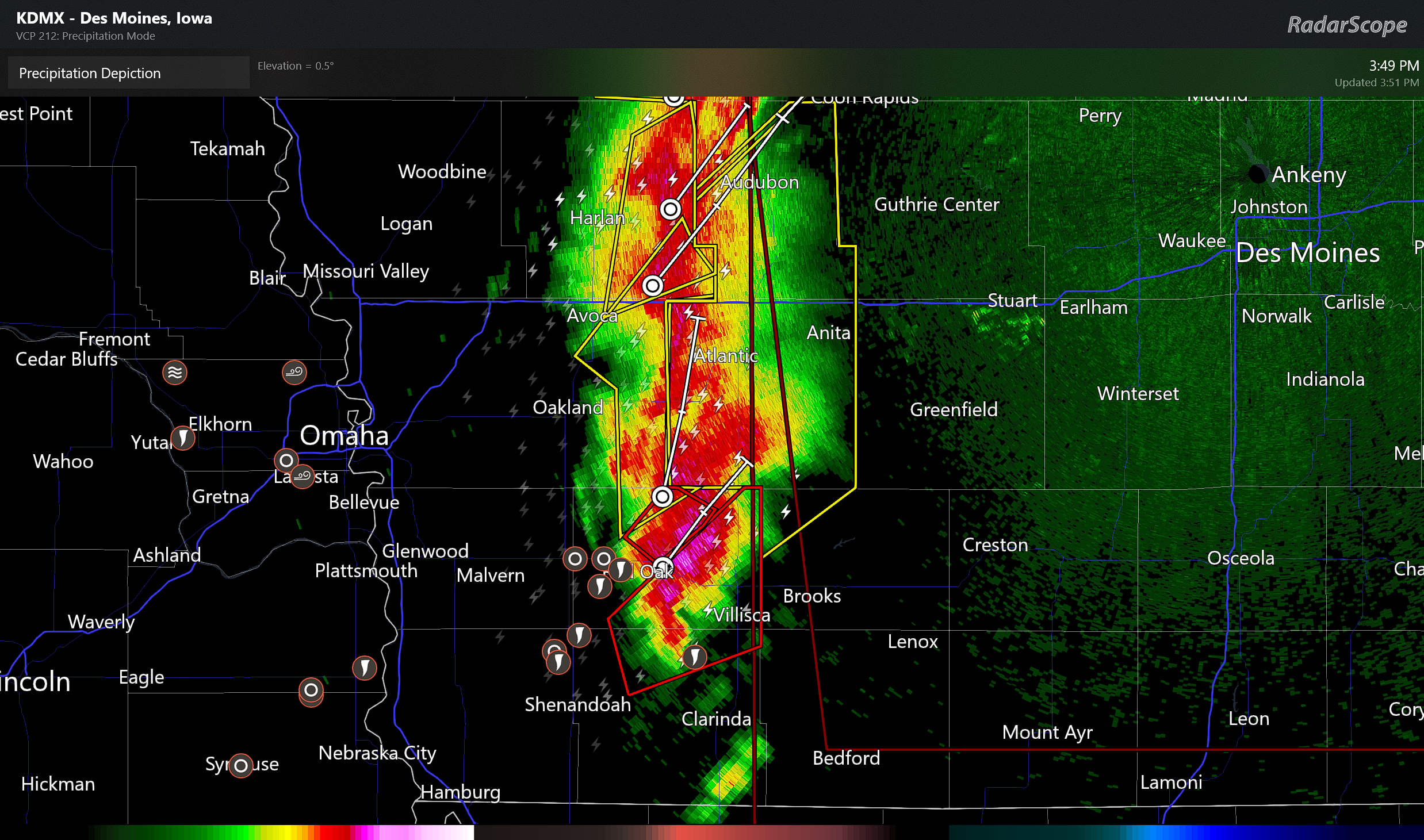
tornadoes on the ground in SW Iowa
Massive tornado got caught on reed timmers YouTube channel. It was a tornado surrounded by mini vortexes. Absolutely the craziest tornado footage I have seen. Snapped wind turbines like they were toothpicks.
Will be interesting to see how tonight’s setup plays out. Models don’t look overly impressive on storms here. That could change though so we shall see.
.4 inches in my gauge in Hamilton. Tonight could be “interesting” …
While the official rainfall amount for GR yesterday was 0.18” here in MBY I recorded 0.57” is two rounds of thunderstorms one in the morning and one in the afternoon. While there were severe storm warnings for the afternoon storms the morning storm had the most rainfall here. The overnight low and current temperature here is 59 with cloudy skies currently.
Slim
Note there was no severe weather with either storm here NW of Grand Rapids.
Slim
The official H/L yesterday at Grand Rapids was 83/52 there was a reported 0.18” of rainfall, the sun was out 35% of the time. The highest wind gust was 32 MPH out of the W. For today the average H/L is 72/50 the record high of 91 was set in 1977 the record low of 31 was set in 1969 the most rainfall of 2.46” fell in 2004. Last year the H/L was 76/42.
Slim