Yesterday we had a sunny warm day with a high of 49° after recovering from a low of 11.5°.
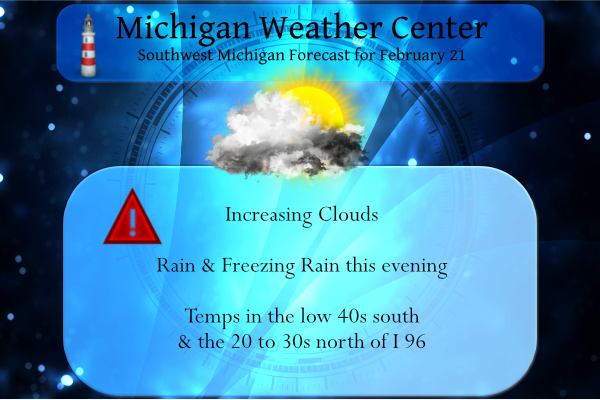
We have a large variation in temperature setting up for today which will set up the demarcation zone between rain and freezing rain:
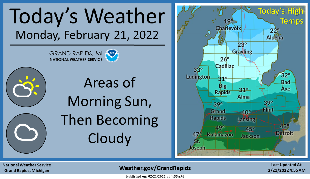
Some morning sunshine is expected in parts of southern Lower Michigan this morning, but skies will otherwise become cloudy today. Rain showers will begin this evening, with freezing rain expected across portions of central and northern Lower Michigan.
We have an interesting weather pattern shaping up beginning this evening. Below are the current hazards for the lower peninsula:
...WINTER STORM WATCH REMAINS IN EFFECT FROM THIS EVENING THROUGH
TUESDAY EVENING...

* WHAT...Heavy mixed precipitation possible...starting tonight and
  continuing through Tuesday evening. Total snow accumulations of
  up to 4 inches...with potential ice accumulations of around one
  half of an inch possible. Winds could gust as high as 35 mph.

* WHERE...Portions of Eastern Upper and Northern Lower Michigan.

* WHEN...From this evening through Tuesday evening.
...WINTER WEATHER ADVISORY IN EFFECT FROM 7 PM THIS EVENING TO
MIDNIGHT EST TUESDAY NIGHT...

* WHAT...Freezing rain expected. Total ice accumulations of one
  tenth to one third of an inch.

* WHERE...Mason, Lake, Osceola and Clare counties.

* WHEN...From 7 PM this evening to midnight EST Tuesday night.
...WINTER WEATHER ADVISORY IN EFFECT FROM 7 PM THIS EVENING TO
NOON EST TUESDAY...

* WHAT...Freezing rain expected. Total ice accumulations of one
  tenth to one quarter of an inch.

* WHERE...Oceana, Newaygo, Mecosta and Isabella counties.

* WHEN...From 7 PM this evening to noon EST Tuesday.
...WINTER WEATHER ADVISORY IN EFFECT FROM 7 PM THIS EVENING TO
NOON EST TUESDAY...

* WHAT...Freezing rain expected. Total ice accumulations of one
  tenth to two tenths of an inch.

* WHERE...Montcalm and Gratiot counties.

* WHEN...From 7 PM this evening to noon EST Tuesday.
...WINTER WEATHER ADVISORY IN EFFECT FROM 8 PM THIS EVENING TO
NOON TUESDAY...

* WHAT...Freezing rain expected. Total ice accumulations of one
  tenth to two tenths of an inch.

* WHERE...Midland, Bay, Huron, Saginaw and Tuscola Counties.

* WHEN...From 8 PM this evening to noon Tuesday.
Forecast Discussion
The main forecast task with this update has been assessing freezing
rain coverage/amounts and associated impacts for tonight into Tue.
Latest GOES WV imagery depicts a deepening western CONUS trough,
along with a lead impulse over NW Mexico. A mid/upper-level jet
streak was diving into the western periphery of this trough,
contributing to 500-mb height falls of 90+ m per 12 h. At the
surface, surface cyclogenesis is underway across the CO/WY high
plains, with a frontal boundary and associated baroclinic zone
extending northeastward toward the Great Lakes.

While ensemble and deterministic guidance continues to incrementally
converge, crucially important differences still exist that lend to a
still-challenging forecast at this hour. Surface low positions in
the ECMWF ensemble (EPS) remain tightly clustered around a mean
position in northern IL at 18z Tue. However, this mean position
has nudged slightly northward in recent runs. The corresponding
GEFS mean surface low position at 18z Tue is east of the EPS
position, with members more loosely clustered over NW Indiana.
This GEFS mean-low position has also trended NW in recent runs,
generally lagging that of the EPS.

With a tight baroclinic zone, these subtle positional differences
have important implications for surface temperatures and resulting
precipitation types. Namely, the EPS envelope, with its more NW
clustering, is decidedly warmer than the GEFS envelope for our
forecast area, with many areas in the EPS traversed by the cyclone
warm sector--yielding a limited extent/duration of subfreezing
surface temps and lower overall freezing-rain potential. Notably,
the 00z deterministic ECMWF surges above-freezing temps northward
over nearly the entire forecast area by 18z Tue, while the 06z
HRRR maintains subfreezing surface temps over our NE counties at
that time.

We will opt to hoist a Winter Weather Advisory for counties covered
by the existing Winter Storm Watch, plus Montcalm and Gratiot
counties. For all but the northern-tier counties, we will plan on an
advisory ending time of noon Tue, given the expectation of
surface temps climbing above freezing on Tue morning. The
northern-tier portion of the advisory is planned through midnight
Tue night. Throughout the entire advisory area, forecast profiles
exhibit intermittent dryness above the frontal inversion, along
with weak MUCAPE (for elevated parcels), suggesting that freezing
rain will likely be showery. Our main concern with this freezing
rain is travel impacts, and a continued trend toward a warmer
scenario is possible.

For most of our forecast area, we expect ordinary rain with this
event. 00z HREF guidance suggests that ~100-300 J/kg MUCAPE will be
present in our southern counties as the warm sector expands
northward, mainly after midnight tonight. Here, some occasional
lightning strikes are possible with any sustained updrafts. Overall
precip coverage throughout the forecast are will likely taper
considerably after 20z Tue as the mid/upper-level dry slot quickly
advances northeast.

- Another system late week

We continue to monitor another possible system for the Thu night /
Fri period. While key details are still uncertain, thermal
profiles suggest an all-snow scenario is favored, with light
accumulations (4" or less) possible for our southern forecast
area, based on available GEFS/EPS probabilities at this early
stage.
Still only 36 degrees is GR! Wow!
The cold and snow just keeps coming despite the warm weather fantasies and talk of winter being mild and over! Total delusion!
https://www.pivotalweather.com/model.php?p=snku_acc&rh=2022022118&fh=240
Boy Wood tv 8 has all 20’s on the 8 day forecast looks like more below normal temps on the way with a possible snow storm Friday great scotty…InDY
Who knew?
I was outside and noticed something in my garden. Some of my early Spring plants are coming up. I think it’s a bit early but maybe with the warmer weather they came up.
Short lived cool down after tomorrow, then right back into the 40’s!! Who knew?!?!!
https://weather.com/weather/tenday/l/b4ea0280869baa46799dc75eacef8904785ec43ad2f6fb098355fbc208a55e2c
Wrong!
Phew, 48 degrees yesterday and barely any snow left. And rain today. Winter continues to head out as we work our way into spring. The best time of year!
Let it melt, Let it melt, Let it melt!
Bring on Spring!!
Im getting snow tired its been a cold dandy of a Winter fun!! The ice fishing will go on well into March the ice is thicker then thick for this time of year …let me fish let me fish let me fish ….InDY..
It has been an incredible winter and more to come!
Sunshine, winds and warm temperatures melted most of the snow yesterday. So now there are just traces of snow on the ground here along with the old snow piles. The high yesterday was a wind blown 48 and the overnight low was 28 before rising to the present 32. It now looks like it will be just a cold rain here for this event. We are now less than 3 weeks away from when in most years the snow will be mostly gone except for the occasional snow events we still can get for all of March and early April… Read more »
I’ve got some good news and some bad news! The word for the rest of this month is COLD! Now for the bad news – no major snowstorms are on the horizon! Plenty of time for that to change, especially with all the cold air that will be around for at least the next 2 weeks! Incredible cold for late Feb/early March!