Yesterday we had 1.1 inches of snow which give us 21.4 inches for the month and 52.4 inches for the season. We are already a foot over last winter’s total and we have had an inch of snow or more on the ground since January 2nd. Yesterday’s high was 31° and the low was 10°.
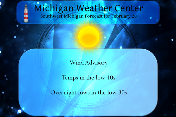
We have a storm warning for Lake Michigan today with waves up to 15 feet and a wind advisory is in place for us landlubbers from 10 am to 6 pm this evening.
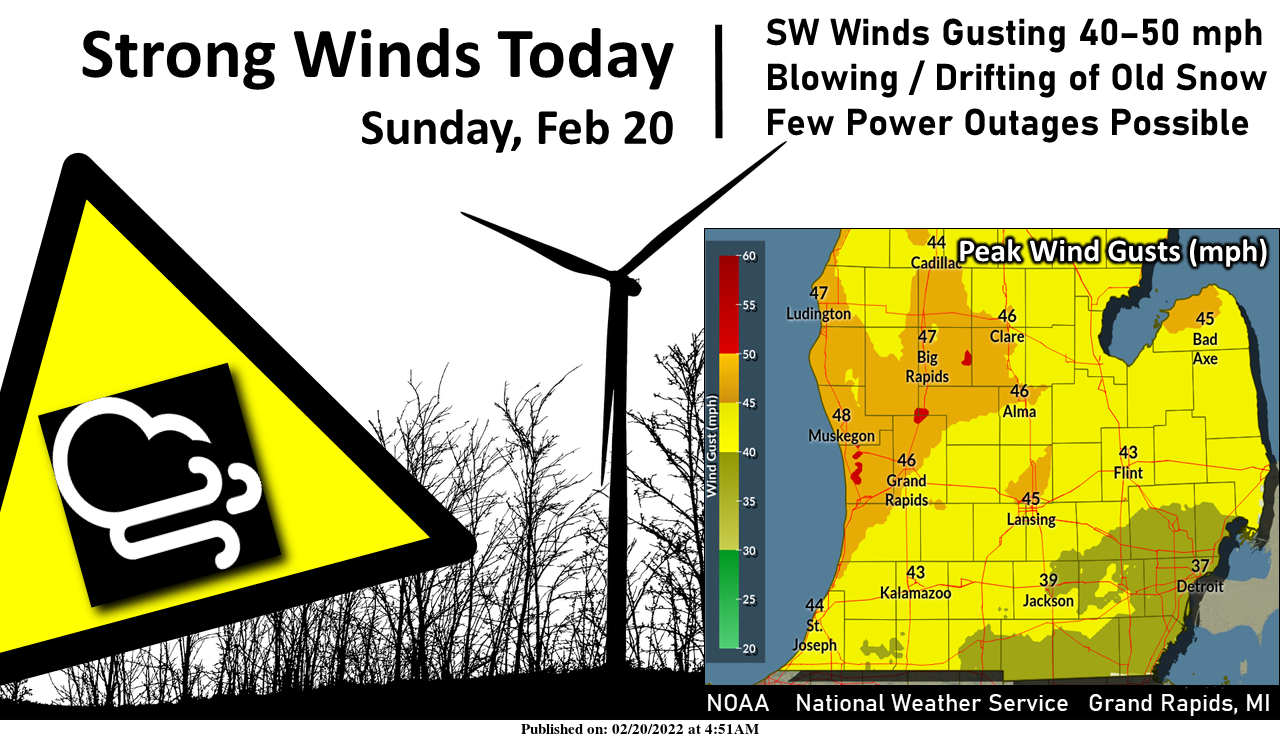
Expect a good deal of sunshine today, but with some brisk winds from the southwest. Gusts of 40–50 mph will cause blowing/drifting of previously fallen snow, especially in open country. A few power outages are also possible. Wind gusts will diminish this evening.
Looking ahead to tomorrow we have a risk for freezing rain:
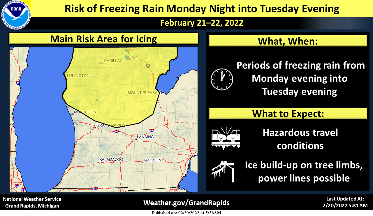
A risk of accumulating freezing rain exists from Monday evening through Tuesday evening north of the I-96 corridor, which may lead to travel disruptions and other impacts.
Forecast Discussion
- Windy today with sunshine

A 993-mb surface low over northern MN at present will reach northern
Quebec by 00z tonight. As this low skirts north of the region, the
low-level pressure gradient will tighten between this transient
low and a 1033-mb high over the Mid Atlantic region. Low-level
wind fields will be impressive, with a 70-80 kt 850-mb LLJ
expected to traverse the region, per recent HRRR guidance.

Based on BUFKIT profiles, confidence is fairly high that advisory-
level gusts (45 mph) be attained over the forecast area today.
While low-level warm advection typically reduces turbulent mixing
near the uppermost portion of the PBL, the enhanced wind field
today will coincide with reasonably strong insolation. Thus, even
with a snow-covered /high-albedo surface, we are reasonably
confident that sunshine today will sufficiently contribute to the
sensible heating/vertical mixing needed for advisory-level gusts.
Blowing/drifting of the existing snowpack will be the main impact
of these winds, although some isolated power outages are again
possible.

- Wintry precip Mon night into Tue

A cold front will move southward through much of Lower Michigan
tonight, likely stalling over far southern Lower by 12z Mon.
Upstream, a mid/upper-level jet streak will dive southward along the
western periphery of the western CONUS trough beginning tonight,
contributing to height falls along the trough axis. A cutoff low,
presently off CA / Baja Peninsula, will become an open wave and
undergo weak phasing with the amplifying main trough to its north.
In response to the approach of these waves, surface cyclogenesis
will commence Mon across the CO plains. The resulting surface low
will pull eastward on Mon night and begin to propagate along the
front/baroclinic zone toward the southern Great Lakes.

The EPS mean surface low position at 18z Tue has been latitudinal
consistent in recent runs. Its most recent run (00z Sun) depicts a
mean low position near Chicago. The corresponding GEFS mean has
shifted NW (towards the EPS), with a mean low position over NW
Indiana.

With this northward shift in the GEFS toward the EPS, a warmer, all-
rain scenario is increasingly favored for much of our southern
forecast area. Consequently, the main threat of accumulating
freezing rain from Mon night into Tue appears to be materializing
across our northern counties--generally north of a Grand Haven-
Rockford-Ithaca line. However, we emphasize that the southern extent
of the freezing rain risk may still change with subsequent guidance,
given the lingering ensemble uncertainty.

Overall, an uptick in precipitation coverage is expected after 00z
Tue as QG forcing for ascent increases in advance of the surface low
--aided, in part, by a developing coupled upper jet structure and
midlevel frontogenesis. Where freezing rain occurs, travel impacts
are possible by Tue morning. The arrival of a midlevel dry slot by
Tue afternoon/evening, signaled in the deterministic GFS and ECMWF,
will likely bring an effective end to most precip from this event.

- Another system late week

Additional precip is expected for the Thu night / Fri morning
timeframe. While details are uncertain at this forecast range, the
most likely scenario is a period light snow from a passing
deformation zone.
I predict that GR will be seeing at least 2 more decent size snow storms! Get ready for the fun!
Winter Storm Watch for our Northern counties for up to 0.4” of ice.
They can keep it up there!
The lakeshore has tons of ice on the lake currently! Many hundreds of yards! Go check it out because it is a great sight! Incredible!
Windy but another bright and mild day. 47 degrees out and the yard and fields are 80% snow free again. Heading out to the beach to watch the big waves knock apart the remaining ice structures for the season.
It does feel like an early March day today. I’m really enjoying it!
Barry, is the ice gone at the lake shore? with the winds the lake must have a lot of open water. It is sunny and windy here some of the wind gust are up to 55MPH the temperature here is now up to 48.
Slim
Slim I was out there this afternoon and the ice is still at the lakeshore. Way out I could see open water with ice moving. Lots of people on the pier which is nuts. I could see where the hills of ice have crack in it.
Ice goes out 100’s of yards! Fantastic!
We went to Holland park this evening. The beach is completely snow free as it has all melted, just sand. The ice does go out a ways but the big waves were busting it up pretty good. As Sandy said there were a lot of people there, but we did not go out very far as you could see and hear the cracking. I really didn’t want to be standing on a piece as it cracked off and floated away.
The 4-5” of snow we received the other day is all but gone. More green than white in the yard.
I just took a long hike back onto State land to the Grand River to check out the ice jam and it’s definitely plugged up. Got some great pictures. Hopefully people along the river don’t have big flood issues with this.
Possible snowstorm by Friday night!
GREAT NEWS FOR WINTER ENTHUSIAST! Plenty of snow chances coming up and the CPC shows below normal temps for at least the next 2 weeks! How could it get better than that as we head into March! Keep this great winter and rock n roll party cranking! Fantastic!
It now looks like most of the bad freezing rain will stay to the north of Grand Rapids and most of the snow later in the week will stay to the south of GR. With snow on the ground since late December I would think it is time to think spring. At this time it is sunny and 30 here.
Slim
Agreed on the the freezing rain, however the EURO is showing us getting. 2 to 4 inches of Snow! Forget looking at the GFS!
This coming week/weekend does look pretty cold… but we are approaching March and average highs in the 40s are just a couple weeks away. So you’d think the snow cover only has a few weeks left before it is melted. We will see though
Yes and I will take about 3 more weeks of winter!
I love winter and snow, but hate ice. This is one time I hope it misses.
100% agree! Bring on tons of snow, but never freezing rain!