...ICE STORM WARNING REMAINS IN EFFECT UNTIL MIDNIGHT EST
TONIGHT...

* WHAT...Significant icing. Snow and sleet accumulations of up to
  one inch and ice accumulations of two tenths to four tenths of
  an inch.

* WHERE...Portions of Northern Lower Michigan.

* WHEN...Until midnight EST tonight.
Benzie-Grand Traverse-Kalkaska-Crawford-Oscoda-Alcona-Manistee-Wexford-Missaukee-Roscommon-Ogemaw and Iosco counties are included in the warning.
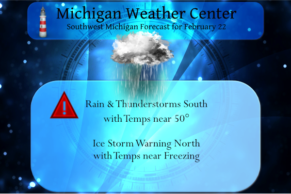
We may see a thunderstorm today over the rest of the area as temps climb to 50 south of I 96.
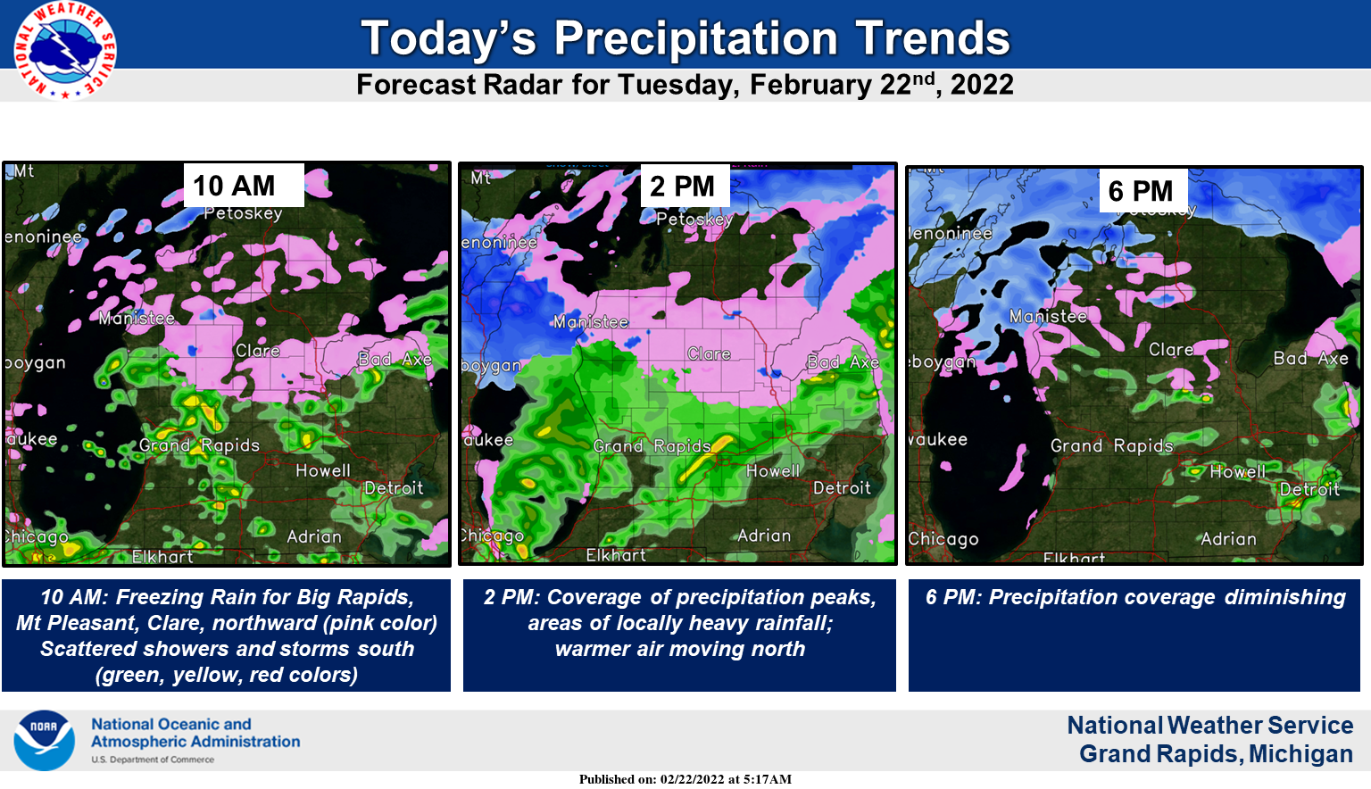
Precipitation coverage will increase this morning, peaking early this afternoon. Freezing rain will create hazardous travel north of Interstate 96 this morning, and mainly just near and north of U.S. 10 this afternoon. A few thunderstorms are possible today and some areas could see over a half inch of rain.
Forecast Discussion
- No changes to Winter Weather Advisory for this update
- Freezing rain and travel impacts today for our northern CWA

A surface low is located over northeast MO as of 08z, with a
sharp quasi-stationary boundary extending northeastward from this
low and draped just south of our CWA. Short-range guidance
suggests that this low will reach the vicinity of GRR by 18z
today, and later to the southern end of Georgian Bay by 00z
tonight.

Precipitation coverage has been slow to increase, but a gradual
uptick in reflectivity has been noted over our southern counties
as of 08z. Strong frontogenesis along the baroclinic zone and a
coupled upper jet structure will provide increasing ascent this
morning/today, and robust low-level moisture transport will occur
on the nose of a LLJ situated to the south of the region. Thus, a
continued increase in precipitation coverage is expected.

At 08z, the surface freezing line runs from near Whitehall, to Grand
Rapids, to near Alma. Deterministic guidance provides still-
differing scenarios on the northward advance of this freezing line
today ahead of the surface low. The ECMWF pushes this line through
most of our CWA by 18z, with the HRRR being slower/colder.
Regardless of these details, forecast profiles to the north of this
line support freezing rain today. Steep midlevel lapse rates and
weak elevated CAPE suggest that cellular/showery elements will be
common. Ice accretion amounts of one-quarter inch or less are
still expected across the advisory area today, with highest
amounts likely confined to near the US-10 corridor. Difficult
travel conditions are expected today within the advisory area, but
impacts will be relatively short in duration across the southern
portions of the advisory, given the expectation that surface
temperatures will warm above freezing in these areas. For the
remainder of the CWA, ordinary rain showers are in store for
today. Higher MUCAPE suggests that some thunder will be possible
with any more robust convective elements.

Precipitation amounts will need to be watched closely. Amounts of
0.2 to 0.6 inches should be common, but HREF guidance suggests
that some concentrated swaths over 1 inch are possible. Precip
amount/placement today may contribute to additional hydro concerns
in the days ahead (see section below).

Expect a quick decrease in precip coverage after ~20z as the dry
slot arrives overhead. Some lake-effect snow showers may occur in
our NW counties tonight, but accumulations are expected to remain
under an inch.

- Light snow Thu night into Fri

After the current system departs eastward tonight, surface high
pressure will build into the northern plains on Wed. A tight
baroclinic zone will still be present across the central CONUS,
although displaced southward by this high. Meanwhile, a shortwave
trough--currently near the WA coast--will dive southward into the
base of the western CONUS longwave trough and reach the southern
Rockies by 12z Thu. This shortwave will contribute to surface
cyclogenesis over eastern TX on Thu, with a surface low quickly
propagating NE along the baroclinic zone, reaching the vicinity of
SW PA by 12z Fri.

The deformation zone and associated frontogenesis will likely
traverse much of our area, and ensemble guidance has been
consistent in signaling a period of light snow from Thu night into
Fri. Light accumulations (4" or less) are still expected, with
some travel impacts possible for at least portions of our CWA,
especially on Fri morning.

- Dry Fri afternoon into Sat; small chance of snow Sun; lake-effect
snow possible into Mon

Looking farther ahead, a cold front will likely approach on Sunday,
extending from a low in Quebec. Aloft, the GEFS/GFS indicate a
somewhat more amplified midlevel shortwave than the EPS/ECMWF. Some
snow may accompany these features, but amounts are likely to be
modest, given the limited depth/duration of available moisture.
Another bout of cold air will arrive behind this front, with 850-mb
temps falling to near -18C, possibly supporting a period of lake-
effect snow showers into Mon.
Areas of freezing rain are expected today, generally north of a
line from Muskegon to Grand Rapids to Ithaca. Within this area,
icing amounts will range from a light glaze across the south, to
one-quarter inch near the US-10 corridor. Hazardous road
conditions are expected today in this area, with greater impacts
occuring with northward extent.

Areas of locally heavy rain (over 1 inch) are also possible
today. This rain may lead to ponding of water in low-lying areas
and contribute to river rises. The risk of ice jams on area rivers
will also continue in the days ahead, especially on the Grand
River. Residents living along rivers should have a plan to monitor
river updates and respond if levels rise quickly.
Great news! The latest CPC shows no above normal temps for weeks! Meanwhile bring on the snowstorm for Thursday night! Incredible!
Just keep adding snow to our already above average February thats great news ….InDzy
The cold and snow just keep coming!
Wow!!! Turning out to be a very short cool down this week! Who Knew?!?!?
Someone let mookiees know it never hit 50 degrees in Rockford today not even close another swing and miss shall we say…InDzy
50 degrees? How about GR never even hit 40 degrees!
The snow maps are looking better and better despite the warm weather fantasies! Incredible!
https://www.pivotalweather.com/model.php?p=snku_acc&fh=342
Those are the same models that said we’d have 20” of snow on the ground here in GR by February 19th! What a joke!!! AccuWeather is 10,000 times more accurate than those junk models you post!!
Clueless!
Hopefully you all can see the image with this link. This was the icing this afternoon where I was in Northern Gladwin County about 7 miles northwest of the city of Gladwin.
https://ibb.co/HzxxqtR
Some serious stuff. Probably some power outages?
There are some scattered outages. The side roads were essentially impossible to travel just glaze ice. There was little traffic on M-18 all day long. This was a pretty serious ice storm. The birch trees are sagging pretty good so if we get any wind the outages will probably go up
Get any wind? It got pretty gusty here around 7pm… hopefully it stayed south of you
So much for GR getting temps in the mid to upper forties! What a joke!
Never even hit 40?? Did it lol..InDY
Look at all that snow for snow country! Skiing till April? What a winter it has been and no let up in sight!
https://www.pivotalweather.com/model.php?p=snku_acc&rh=2022022212&fh=384
Anyone who visits this site knows that there are a few personas that post on here their views on if a season is cold and snowy or hot and humid. Now as for this current winter season here are the facts not the hype. November while not a winter month there is usually snow and cold that month and last November had a mean of 38.5 (-1.5) and there was 9.7″ of snow fall. December had a mean of 34.5 (+4.1) and there was 10.1″ of snow fall. January had a mean of 20.8 (-4.6) and there was 25.8″ of… Read more »
I would argue that the warm December we had with very little snow made this winter short in terms of big snow and cold.
I would argue the cold and snowy November made this winter seem longer and incredible!
A whopping 9” of snow all month is true winter to you? LOL
Like I said a very typical winter season for our area.
Slim
Yea this is about as normal of a winter as you can get. No winter is completely normal.
I’m currently up in Gladwin County (Ice Storm Warning area) and wow! Lots of ice buildup on the trees. Getting some great pictures
Thanks for your information.
Slim
Stay safe!
There around a 20° temperature difference across the area at this time. With low 50’s to the south and low 30’s to the north. Here at my house at this time there is light rain falling with a temperature of 35.
Slim
Here are my observations from this mornings commute from north crystal lake (Montcalm co) area to Mt Pleasant. The temps were steady at 32-33F, and there was signs of ice buildup on road signs, trees, and powerlines. But it was minimal. Crystal lake area rainfall is pretty steady with nice down pours. Mt. Pleasant has more evidence of ice and not as much rainfall. The paved roads are clear, but the backroads are completely ice covered and extremely slippery. The biggest hazard was minor road flooding due to frozen ditches and fields. The water is spilling onto the roads in… Read more »
Ice is starting to pick up a bit in Mt. Pleasant. Looks like the temp dropped to 31 and its still lightly raining.
Get ready for over one week of mid winter cold starting tomorrow! Incredible winter so far and still rocking! Wow!
Looks like 8 days in the 20’s/30’s but not much snow. The last hurrah of winter? Several forecasts are saying so. I love it!
.UPDATE… from the Gaylord office Issued at 1039 AM EST Tue Feb 22 2022 Latest surface obs display a stationary front draped from the tip of the thumb back west across southern Michigan through the Saugatuck area. Position of this surface boundary is not expected to change much over the next several hours despite strong mid-level warm advection, leaving the vast majority of the CWA in sub-freezing surface temps through the day. The main forecast change will be shrinking the expected area for sleet and snow further south. Based on the latest forecast soundings from the high-res guidance suite, expectation… Read more »
Clinton MI-Gratiot MI-Ingham MI-Calhoun MI-Allegan MI-Ottawa MI- Barry MI-Van Buren MI-Jackson MI-Kalamazoo MI-Montcalm MI- Muskegon MI-Ionia MI-Eaton MI-Newaygo MI-Kent MI- 838 AM EST Tue Feb 22 2022 …Thunderstorms will impact portions of Van Buren, Kent, Ingham, Gratiot, Ionia, Barry, Clinton, Muskegon, Montcalm, Calhoun, Allegan, Jackson, Ottawa, southern Newaygo, Kalamazoo and Eaton Counties through 1230 PM EST… At 836 AM EST, Doppler radar was tracking thunderstorms out over Lake Michigan. These thunderstorms have a history of producing hail up to nickel size over the Chicago area. The storms have weakened some, but will have the capability of producing penny size hail… Read more »
Closing in on a half an inch of rain already. Temps near 50 with thunderstorms, did we jump right into April?
Accuweather has been reliable in February. If the current forecast holds, winter will be dead by March 3rd. I don’t see a single high temp below freezing after that.
AccuLessweather has been absolutely the worst on snowfall forecasts this winter! They are a joke! I would not trust their forecast if they were the last site on Earth!
Weather.com is saying the same too! Looks like the cold weather crazies just can’t accept the facts!
Lol you guys are too much! Warm Spring weather delusions are out of control! We will still be seeing some snowstorms, so get ready and mark it down!
Oh I forgot, you consider it a snowstorm when we get 1 inch of snow overnight.
Radar showing some lightning near Alamo. Just got back from Allegan – lots of fog and heavy rain between there and Otsego. Temp is at 47 with rain currently.
What a winter! Below normal temps, near normal snowfall, great winter sports and more cold and snow is on the way! Wow, just WOW! Incredible!
“Near normal snowfall” is that your way of saying below average snowfall? Continual spin from the winter crazies. Yikes!
Looking like 3 to 5 inches of snow coming Friday and temps into the 20’s I wouldn’t say its Spring just yet just commen sense I say ..Indy…
You must be confused or trying to spin. Nobody said we won’t get any more snow LOL
Thursday night into Friday the NWS says 4″ or less is possible. Still a ways off, we will see, but that’s what he is referring to.
Looks like another Winter weather advisory coming for Friday nothing new we have had winter weather advisorys in April the last 2 or 3 years this year will be no different im sure ….InDY
Sounds great and we have plenty of winter weather left to enjoy despite the constant warm weather hype! Wow!
The warm weather nuts are off their rocker as usual! Winter is still rocking and bring on the snow!
Not for me in my point forecast!
Thursday
A 30 percent chance of snow showers after 1pm. Mostly cloudy, with a high near 26. East northeast wind 8 to 13 mph, with gusts as high as 22 mph.
Thursday Night
Snow showers. Low around 16. Chance of precipitation is 90%. New snow accumulation of around an inch possible.
Friday
Mostly cloudy, with a high near 25.
Friday Night
Mostly cloudy, with a low around 13.
Saturday
Mostly sunny, with a high near 28.
A whole inch! LOL
LOL!!! Yep, that point forecast covers the whole northern half of Kent County.
More GREAT news about WINTER! The rest of this month we will be seeing mid winter like temperatures and plenty of snow chances! Safe to say winter type weather will carry on well into March! I love it! Who wouldn’t want snow this time of year?
More GREAT news about WINTER! There are only 6 days left in this month and as the calendar turns so does the weather! Plenty of 40’s as we start March and all the snow has melted already for this month! SPRING is coming on very, very soon!! Who knew?!?!!
https://weather.com/weather/tenday/l/b4ea0280869baa46799dc75eacef8904785ec43ad2f6fb098355fbc208a55e2c
The ski resorts are dead after this huge melt and rain, ice fishing is definitely a no go, cross country skiing and snowmobiling would only be on mud. What winter sports are you referring to? LOL
This has been a short winter for recreation! Basically 6 or 7 weeks is all.
Lol..Yes its been definitely a long 6 or 7 weeks under that rock hu?? ….InDY
Yesterday we had a high temp of 52 degrees after a low of 26.
Most of the snow cover here is now gone all that is left is some snow in the woods and of course the snow piles. The overnight low here was 31 and at this time with a light cold rain falling it is 34. It now looks like the next week or so will be cold but not much in the way of any snow. The 30 year average mean for the last 3″ or more snow fall is February 27th (note the latest was April 19th 2019 so yes it can happen) so we are now at the time… Read more »
Chance of 50 degrees and thunderstorms! I love it!
I see some lightning now NE of Greenville. There’s some in the Chicagoland area, so hopefully that will drift into our areas.
Yes! Bring on some February storms!
Currently 34* degrees with cold rain fallen outside…Lets be real here..InDY
Pretty warm for 9am in February!