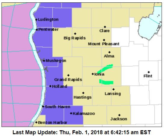
 We here along the lakeshore shall begin picking up some lake effect snows later today, not a whole lot by Michigan standards but enough to cover the ground again with 2 to 6 inches from 131 to the west.
The winter weather advisory covers Ottawa, Allegan, Van Buren, Kalamazoo, Mason, Lake, Oceana and Muskegon counties counties.
An Arctic cold front will push through Lower Michigan this morning, which will send temperatures tumbling this afternoon. Highs will occur early in the day in the 30s, dropping into the teens this afternoon.
Lake effect snow showers will develop this morning north of Holland, spreading southward this afternoon. Lake effect snow will peak in intensity tonight and gradually end around midday on Friday.
Accumulations of 2 to 6 inches are expected towards Lake Michigan will poor travel conditions developing. The snow combined with cold temperatures will make for slick roads from this afternoon through Friday morning towards the lake.
A short respite from the snow is expected Friday afternoon and evening before a more widespread synoptic snow event develops for Saturday into Sunday then transition back to lake effect. Travel over the weekend will be impacted by snow so take care. It appears the snow will be around through next week with the possibility of another synoptic event on Tuesday.
So, after a short respite from the biting cold we will return to our igloos and have some family time in front of the fireplace with penguins in place ready to watch the Super Bowl.
Today: A 50 percent chance of snow showers. Cloudy, with a temperature falling to around 16 by 5pm. Wind chill values as low as zero. Blustery, with a west northwest wind 13 to 21 mph, with gusts as high as 32 mph.
Tonight: Snow showers likely, mainly after 4am. Mostly cloudy, with a low around 11. Wind chill values as low as -3. North northwest wind 7 to 15 mph, with gusts as high as 23 mph. Chance of precipitation is 70%. New snow accumulation of less than one inch possible.
Friday: Snow showers likely, mainly before 7am. Mostly cloudy, with a high near 17. Wind chill values as low as -1. West wind 7 to 13 mph. Chance of precipitation is 60%. New snow accumulation of less than a half inch possible.
Friday Night: A 50 percent chance of snow showers. Mostly cloudy, with a low around 13. Wind chill values as low as -2. South southwest wind 8 to 14 mph.
Saturday: Snow showers likely, mainly after 1pm. Cloudy, with a high near 29. Southwest wind 9 to 13 mph. Chance of precipitation is 60%. New snow accumulation of less than a half inch possible.
Saturday Night: Snow showers. Low around 19. Chance of precipitation is 80%. New snow accumulation of around an inch possible.
Sunday: Snow showers likely. Cloudy, with a high near 24. Chance of precipitation is 70%.
Sunday Night: A chance of snow showers, mainly before 1am. Mostly cloudy, with a low around 9.
Monday: A slight chance of snow showers. Partly sunny, with a high near 22.
Monday Night: Snow showers. Cloudy, with a low around 14.
Tuesday: Snow showers likely. Cloudy, with a high near 28.
Tuesday Night: A chance of snow showers. Mostly cloudy, with a low around 12.
Wednesday: A chance of snow showers. Mostly cloudy, with a high near 25.
We got about 2″ of snow drifts are a little deeper. It is good hibernation weather tonight.
FEBRUARY !!!!!!!!!!! Made ME!!!!!!
“””””SHIVER”””””””!!!!!!!!!!!
Name That TUNE??
American pie!
https://www.youtube.com/watch?v=uAsV5-Hv-7U
Winter is back let’s finish strong all the way to May yeaaaa! INDYDOG14!!
Really?? I would love to see an early Spring. LOL!!
Snow map through Sunday! This is the best SNOW map that I have seen for awhile! Bring it on and then more SNOW next week! I love it!
http://www.weather.gov/images/erh/gis/LP_state_Snow.png
What a great forecast form the NWS! Bring it on and lets see an overachiever! TONS of SNOW is on the way! Get you snowblowers ready to roll!!!!!!!!!!!!!!!!!!!!!!!!
Confidence is high for a period of moderate snow Saturday
afternoon through Sunday afternoon as sfc wave tracks along
arctic front draped across the lower Great Lakes. F-gen forcing
should be sufficient for banded precip and model soundings show
lift through a deep, saturated dendritic growth zone from Saturday
afternoon into Sunday afternoon. these type of f-gen events can
bring locally heavy amounts where the narrow bands pivot…so
local amounts over 8 inches are possible by Sunday morning.
SNOW, SNOW and more SNOW! Pattern change here we come!!!
http://www.instantweathermaps.com/GFS-php/conussfc.php?run=2018020118&time=PER&var=ASNOWI&hour=384
Rock N Roll will never die!!
http://wxcaster.com/gis-gfs-snow-overlays2.php?STATIONID=GRR
Here’s a screen grab off our webcam. You can see the lack of snow piling up:
http://tinypic.com/usermedia.php?uo=NuVqmzAy%2FKz88TzDfa0CAIh4l5k2TGxc#.WnOXCUtOmhA
Brrrrr….That Wind is RAW.
Dusting of Snow HEAR @ Thee YOCS
Same here. 8 hours into the warning or whatever we are in and the ground is still mostly bare.
Yup a UNDER PERFORMER in MY HUMBLE OPINION
Even less snow this year than last winter! “Michigan is covered with snow on 72% of the land. The average depth is six inches, which comes from much higher snow cover on northern Lower and the U.P. Last year Michigan was 90% covered with snow at this time of year. The average snow cover was seven inches. Right now it looks like February won’t change the dryness since we are going into a colder pattern dominated by a lobe of the polar vortex. The colder than average air in the eastern U.S. for February won’t hold much moisture. In other… Read more »
The morning started out with a temperature of 35° here at my house and it is now down to a windy 21° with cloudy skies. There have been a few snow flakes around but nothing more, so the ground is still brown.
Slim
With the start of a new month I will bring back the Climatology for the day post.
Climatology for today February 1st At Grand Rapids, MI
The average H/L is 31/18
The record high of 51° was set in 1989 the coldest maximum is +5 in 1971
The record low is -20° set in 1899 the warmest minimum is 40° in 1968
The record snow fall is 8.8” in 2015
The most on the ground was 18” in 1959
Last year the H/L was 36/23 we had 1.2” of snow fall and 5” was on the ground.
Slim
One snow fall item of interest is that in the last 25 years we have set new monthly snow fall records in November 31.0” In 2014, December 59.2” in 2000, January 46.8” in 1999, and February 41.6” in 2008. But you have to go back to 1965 36.0” for March and 1961 15.6” for April and way back to 1923 5.5” for May. Could anyone of the “old” spring records be on the table this year??
Slim
Welcome to February! Other then for the snow piles the ground is bare at the start of the new month. If we have “average” snow fall for the rest of the winter/spring season we would end up with around 72″ of snow fall for just about a “average” seasonal snow fall amount.
Slim
We ended January +0.5 degrees above average with 13 out of 14 warm days in a row and 8″ below the average snowfall for the month. We are now 4″ below average snowfall on the season.
The race will now be on to see if we can reach average snow fall for the season. Generally lake effect becomes less of a player this time of the winter season.
Slim
Hey Slim, where did we end up last year?? Wasn’t it like 59 inches??
60.1″ we only recorded 2.4″ in February then 4.7″ in March and another 0.4″ in April.
Slim
Thanks Slim!
Wow the wind is blowing cold air in to west Michigan we have several clippers on the way with snow and cold many locations will be shoveling the snow is going to start adding up!! Glad to see that brown ground go away .. WWA coming for Saturday for west Michigan! 3-6 inches .. Enjoy Michigan’s second half of Winter! INDYDOG14!!