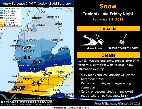
 Lots to talk about today in regards to the next winter storm coming our way. The areas in light blue including Allegan, Barry, Eaton and Ingham counties are under a winter weather advisory which run from 9pm this evening through midnight Friday night. We can expect 4 to 7 inches in these counties. Ottawa, Kent, Ionia and Clinton counties could see 3 to 6 Inches.
Van Buren, Kalamazoo, Calhoun and Jackson counties are in the warning which includes the Interstate 94 corridor (the ares in pink) could see up to 10 inches of snow.
So this is a significant snow event which is setting up for the southern third of Lower Michigan late tonight into Friday. Travel along the Interstate 94 corridor between Detroit and Chicago will become very hazardous on Friday with 6 to 10 inches of accumulation expected. Accumulations of 3 to 6 inches are forecast for the Interstate 96 corridor, but amounts will be much less farther north.
More snow is expected over the weekend, particularly south and east of Grand Rapids as our parade of synoptic storms continue with this being our first major storm of the season. This will definitely be a snowblower worthy event. Below is the NAM model run through Sunday.
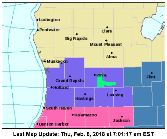
There is the probability that the northern edge of the heaviest snow may move north a bit which could give Allegan county more snow than predicted. I will keep you updated….
What a storm! The SNOW just keeps coming!
Hello GR!
http://wxcaster.com/gis-snow-overlays2.php?STATIONID=GRR
It is snowing lightly here. I wonder if this will change.
https://m.youtube.com/watch?v=M-5zlj49ugk#
Cue:::: Having A Party Rod Stewart – YouTube
▶ 4:45
https://www.youtube.com/watch?v=JQQgt7PCJuk
Tick tick look @ Thee CLOCK…..
IT’S…………………………………………………………..FRYday
Who Do You SPELL BINGO!!!!
Thee JEM Model is HOW!
6-8 inches on thee WAY for The YARDofCUES!!!
Speaking of BINGO!
http://www.weather.gov/images/erh/gis/LP_state_Snow.png
One more snow map for your viewing pleasure!
http://www.pivotalweather.com/model.php?m=nam&p=snku_acc&rh=2018020818&fh=84&r=conus&dpdt=
Bring it!
http://www.instantweathermaps.com/NAM-php/conussfc.php?run=2018020900&time=PER&var=ASNOWI&hour=072
GR is well above normal for seasonal snowfall with a lot of SNOW on the way the next few days! Who knew? Also the CPC now shows below normal temps for most of the rest of the month! INCREDIBLE!
>>>>WEATHER BULLETIN>>>The 18Z RDB model shows the storm tracking farther to the North! GR get ready for 5 to 7 inches of SNOW! The GR NWS should move the WSW up one row of counties!
Do you have a link you could share?
Sandy the RDB model has strict proprietary rights and cannot be published on a public web site! Currently it is a model battle – the GFS vs the dynamic duo (NAM and RDB). Stay tuned.
I get it!! I totally forgot! LOL!!
Haha!!!! That is perfect Jack!!!
Perfect Truth
RDB= Rocky’s Dart Board
LOL!!!
Technically it is the Rockford Dart Board model, however I think that I like the sound of Rocky’s Dart Board!
It has been snowing here all day!!! Some times heavier than others. Guess we’ll do the driveway again today!!! LOL!!!
Yep, gotta make room for the next round of snow! We’ve had afternoon lake effect both yesterday and today and actually this morning as well. No dirty snow around here, LOL.
Same here. LOL!!!
I find it interesting that the Detroit NWS still has a Winter Storm Watch posted.
Why? Do you know that they are not getting it? Just curious- I have elderly family members there that are worried about this storm.
They have now updated it. They basically extended the WWA and WSW due eastward across the state.
http://www.weather.gov/dtx/
Thank-you. That area takes forever to clear their roads when they get that much snow.
Very happy to be squarely in the 1 to 3 inches of snowfall zone!
My cold/flu turned into Bronchitis I feel a little better today but still not 100% yet. It looks like the heaviest of the snow will stay south of the Grand Rapids metro area. Now as for the impacts this event will have I will charm in that while the snow totals are kind of high but without a lot of wind that will help. I am going to look and see just how many big windy snow events there have been (northeast wind events) since the time I have moved to Grand Rapids in 1984. And I will do a… Read more »
Hydration and rest. Hope you’re 100% soon.
Hope you feel better soon!! Lots of rest & fluids. There is a lot of this going around.
Local mets here also say 4-7″. I think it will be a close call for school tomorrow. I know my kids will be sleeping with spoons under their pillows tonight.
Give em a 3 day weekend. 😉
Eaton Rapids will be close for sure…. LOL!! They have been closing for 4″ this year. I am from the “olden days” when schools closed for large dumps of 8″ or more. We have an extremely large rural route, but I really think they are taking advantage of the “free” snow days before make up in June. All the snow days have been Mondays or Fridays … uhm.. imagine that?? LOL 🙂 Hope your kiddies get their snow day!!
I still can’t believe everyone closed this past Monday. But you’re right about the pattern of when they call school. Things that make you go hmmmm…
Growing up in Alpena and Bay City the only times school was closed was during a big windy snow event. For me that only happened twice February 25, 1965 with 17″ of snow and January 25-26 1967 with 33.8″ of snow. Both events had drifts of 6 to 10 feet with NE winds of 45 MPH in 1965 and up to 60 MPH in 1967. In my life time the 1967 and 1987 storms are the benchmark storms that have not as of yet been repeated.
Slim
Hi Mark,
This is ridiculous… Eaton Rapids just called already for tomorrow… Seriously??? I guess they are now going with just the forecast 🙂 Son is happy…. he will be really happy tomorrow when I send him out to shovel since our snowblower broke :):):)!
Plainwell was the first in Allegan county to close and the rest quickly followed.