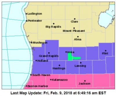
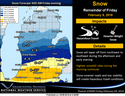
 Latest thinking is that snow will end a little earlier than previously expected, with activity tapering off from northwest to southeast during the afternoon. This map shows how much additional snow will fall after 6AM this morning. Radar estimates and ground reports indicate that we have already seen between 2 and 4 inches over the far southwest corner of Michigan.
Temperatures are cold, 18° here in Otsego. I haven’t been out to measure the snow yet but I would say we have about 3″ thus far at 7am with light snow falling.
Widespread snow will continue to impact southern Lower Michigan today and will be heavy at times near and south of the Interstate 94 corridor. The snow will gradually end from northwest to southeast this afternoon and early evening.
Cold weather and occasional light snow will continue over the weekend, with some additional accumulations expected mainly from Grand Rapids to the south and east. The weather for next week looks much less active, with high temperatures moderating above freezing by mid to late week.
The band of heavy snow that the models have been advertising appears to be currently setting up over Chicagoland and far southern Lake Michigan. It is this band which eventually sets up along I-94 this morning, and could produce inch per hour rates at times in the warning area. While areas of heavy snow are expected this morning, as mentioned above the latest trends in the hi res models is for the snow to quickly diminish or end this afternoon and early evening. For now will maintain our going storm total snow amounts, but the quicker end time could lead to lower totals.
After a fairly unsettled period of weather over the past week or so, we are looking at the pattern settling down a bit. No major snow systems are on the horizon, and temperatures will be moderating to slightly above average levels.
ADA – 4 inches from “the storm”. Very light, snowblower friendly. We have enough on the ground currently to qualify as officially winter.
I saw someone using a leaf blower today blowing snow! LOL!!
Solid 3.5 here….Lol
Top of this Saturday Morning To All from the YARDofCUES…
SPIN~~~~~>.
https://youtu.be/rsYhDSR9mGI
Lordy Lordy I see a Fourty in the near future.
Hmmmm…..I was wondering why Rocky hadn’t posted these today??
http://www.cpc.noaa.gov/products/predictions/814day/814temp.new.gif
http://www.cpc.noaa.gov/products/predictions/WK34/gifs/WK34temp.gif
Bring on the WARMTH!!! Hurry up SPRING!!
https://days.to/until/spring
DING DING DING…..I Agree!!!!!!
#HurrySpring2018
Haven’t officially measured, but eyeballing looks approx 8″ here in Eaton Rapids 🙂 Love it!!
+1
I wonder if the schools will open on Monday? Suppose to get about 3 inches on Sunday night.. LOL!!
GR is well above normal for seasonal snowfall and well above 60 inches for the season! At this rate my prediction of above normal snowfall is almost a lock! 100 inches is well within reach! Who knew? Skiing here I come! I absolutely love it!
You predicted 100+ inches for GR for the season in November, so we’ll hold you to that!
Sounds good 100 inches plus! Bring it on!
What a great storm and what a great month for COLD and SNOW! Keep it coming!
Yes it was……..in Kalamazoo!
WIMPY WIMPY Snow Totals Here in Allendale.
Can’t believe KIDS get out of School For This.
Another JEM Bingo as well.
HaPpY FRYday
Yep Jack not much of a “storm” in mid to northern Kent! Have to look down around Kalamazoo for the big snow totals.
I have had higher snow totals during Lake Effect Events Here in Allendale
Ask Sheri how much snow we didn’t have this past Monday when all our schools were closed.
#teachershangoverfromsuperbowl
7.3 on the day not a bad storm we are sitting about 15 16 inches of snow on the ground not bad for mid February yeaaa!! INDYDOG14!;
Measured 5 spots in the yard, all 8.5 inches deep. Crazy how INDY is only like 15 miles south of me and has twice the amount of snow!
Oh yeah, forgot to say I had roughly 5.5 or 6 inches on the ground yesterday, so we got like 2.5 to 3 inches. So, NWS and WooodTV Were spot on. Ellen Baca just said GR was in the 3 to 4 inch range of snow for the total today. So it looks like from about Mid-Kent County to Northern Kent County it was around 2 to 4 inches. Puzzling why so many Kent County schools were closed today for such a little amount of snow???
Yup
Crazzy how slim has almost 9 inches of snow in the ground 15 hours ago and is a few miles if me add it up Andy yeaaa! INDYDOG14
We’ll have to have Slim give his updated snow total in the morning! Curious to see what he has!
Just came in from snow blowing and shoveling. I’m estimating we received a solid 6″ or 7″. I dug out around the fire hydrant. It was completely encased and almost covered. The snow is more than knee-deep. This is the most snow we have had on the ground at one time in a couple of years.
It has stopped snowing here. I saw something today- a guy blowing snow off his driveway with a leaf blower. Might not be a bad idea when the snow is heavy.
Finally stopped snowing here as well. I’m estimating 6 inches. They stated it would be a heavier type snow but it wasn’t much worse than fluffy type lake effect snow.
Impressive radar in Kent counties and counties east of there that weren’t even in the advisory.
Has anyone else noticed the mid range EURO model has been total garbage this winter! The worst ever! The GFS and the RDB have been superior than the EURO model. I can not believe that people pay extra money to have access to such a horrible model! I say disregard the EURO this winter and go with the always reliable RDB!!!!!
Slim the days of liability is big now plus more parents drive there kids to school then ever schools are scared of something happing and being sued …. unfortunately weather plays a role in that now! INDYDOG14!!
After reading Indy’s schools are closed comment I took a look and I have to say I am “shocked” that schools are closed. I can see a reason for illness but for snow??? come on you have to be kidding right? What would happen when we get a real snowstorm?
Slim
One bad thing with getting Bronchitis is that the cough just lingers on and on. Here at my house I am still getting light snow falling and taking my first measurement in several days I have 2.5″ of new snow (taken on the driveway that was clear last night) and now have a total of 8.7″ on the ground here.
Slim
Still snowing out at thee YARDofBRICKS INDYDOG!!
How could it be snowing the heaviest right over GR great call ROCKY!! Schools are closed this what a storm! I’m thinking 13 inches now for GR!! Yeaaa!! Thank you INDYDOG!!
3″ already, so we’re halfway to the predicted amount.