It is time for our weekly look at past weather events.
February 4
1838: An ice jam on the Grand River causes flooding of much of Grand Rapids during early February. Several people had to be rescued from flooded neighborhoods and at the fur trading post.
1996: One of the coldest arctic outbreaks of the 20th century sends the thermometer down to 17 below zero at Grand Rapids and 19 below at Muskegon, both records for the date.
February 5
1890: Temperatures more like April than February prevail during one of the mildest winters on record in Lower Michigan. Lansing sets a record high of 61 degrees for the second day in a row.
1918: Frigid weather holds on across Lower Michigan with the temperature falling to record lows of 16 below zero at Muskegon and 21 below at Lansing.
February 6
1895: Lower Michigan is in the midst of a week long siege of arctic air. High temperatures struggle through the single numbers while morning lows fall well below zero. Lansing falls to 14 below zero on this date after lows of 24 below on the 4th and 20 below on the 5th. Grand Rapids hits 9 below after falling to 16 below on the 5th.
1938: The weight of ice and water carried away the west side of the Rogue river dam at Childsdale.The Souffrow bridge near North Belmont was closed to traffic as its footing had been swept away by the river. Several houses along the east bank of the Grand River were flooded.
2008: Near blizzard conditions occur across part of Lower Michigan with snowfall rates of one to two inches per hour. More than a foot of snow fell north of Interstate 96 to Route 10. Further south, a wintry mix of snow, sleet and freezing rain occurred from Kalamazoo to Jackson. The storm drops more than 8 inches of snow at Grand Rapids, contributing to the snowiest February on record with 41.6 inches.
February 7
1899: The greatest arctic outbreak in United States history begins a period of extreme cold in Michigan. Grand Rapids hits 15 below zero. During the next week, temperatures will fall to all time record lows across the state and much of the continental U.S.
February 8
1925: A four-day warm spell with highs over 50 degrees across southwest Lower Michigan peaks with a record high of 60 degrees at Grand Rapids.
February 9
1875: The temperature tumbles to 32 degrees below zero at Lansing and 20 below at Detroit during one of the coldest months on record in Lower Michigan. The mean temperature for the entire month at Lansing is 4.7 degrees, the coldest month ever recorded there.
1934: The coldest temperature ever recorded in Michigan occurred at Vanderbilt, with a low of 51 degrees below zero.
February 10
1899: Grand Rapids has its coldest day on record with a high of 6 below zero and a low of 21 below. Muskegon had set their record for all-time coldest high temperature on the 9th with a high of 5 below zero.
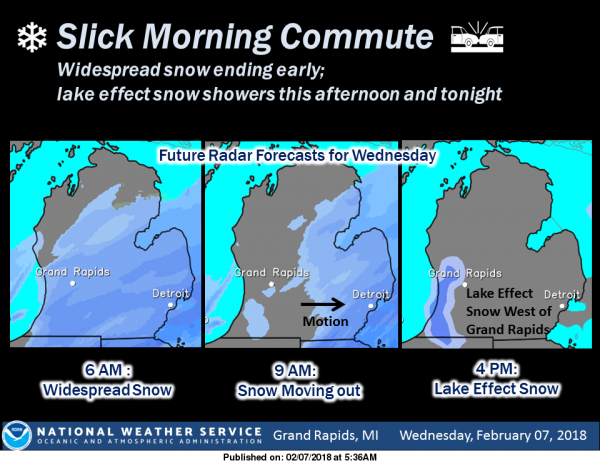
A cold and snowy pattern will prevail through the weekend. Widespread light snow this morning will end by noon then transition to lake effect snow showers west of Highway 131 for this afternoon and tonight. Another widespread snow will impact the area Thursday night and Friday with several inches of accumulation possible. Additional accumulations are possible with another system on Saturday.
Current expectation with the Thursday night and Friday event is for a widespread 4 to 7 inch snow south of a Muskegon to Alma line. The ECMWF is farther north than the GFS/NAM with the axis of heavy snow…. more along I-96 rather than along I-94. We will monitor this as it is still early.
Another system will track across the Ohio Valley Saturday afternoon into Sunday producing light to moderate snow through deformation processes. This system will be fairly dynamic with quite a bit of rain/storms on the south side and then snow on the north across the cwa. The gfs is more bullish with the snow than the ecmwf, which only gives a couple of inches. Given the strengthening of the upper vort moving across the lake, the gfs may have a better handle on this system. Impacts are certainly possible over the weekend as the Friday system winds down and then the Saturday system develops. We should see a warming trend early next week – I will look at that tomorrow.
Not sure if the kids will have school tomorrow or not. It’s going to be close. Last night they said 7-10″, but now they’ve dropped it to 4-7″.
Looks like I-94 to the south will get nailed by this latest winter storm. While other will see lighter amounts.
Only 2 inches or so in my neck of the woods through Friday night! That’s fine with me!
Counting down!
https://days.to/until/spring
http://www.weather.gov/images/erh/gis/LP_state_Snow.png
Yep, 2 or so inches in my area, like I said!
All the recent model runs except the GFS are bringing it farther north. I sure hope the NAM is right. It’s time for a good snowstorm that covers ALL of West Michigan. Seems like that never happens…
We have had some pretty hefty snow showers off and on all day here. Anything to add to the snowpack! 🙂
Hey Matt, you have had a good winter over there. And yes lets hope the NAM is onto something! Rock n Roll will never die! Lately the GFS has been more accurate than the EURO model?
January was pretty boring…but December and February have been “rock”in!!! This has been a winter of lake enhancement snows in these parts. I am up to 90 inches on the season.
I am in Eaton County and I say “Bring it on!!!” I wish it had some winds packed in also, but whatever… snow is glorious snow 🙂
Winds often shred the snowflakes apart, and lower snow accums. My vote is for NO wind. 😛 It’s more fun to walk in the snow when it’s not pelting in your face.
Good positive attitude!
Not sure if you’re being sarcastic? I didn’t mean to come across negative if you were. Just being realistic. 🙂
I knew what you meant , therefore I understood no negativity! I lurk all the time but comment very rare and so I know you are never rude 🙂 . Thanks for your thoughtfulness!
Thanks for your kind words!
I can’t wait to go on my nightly snow-walk tomorrow with the beautiful flakes falling! I hope you enjoy it!
That is the spirit!
Hey ROCKY!!!! GOOD CALL TO ME….Re: Winter Storm Watch.
Jack Edwards
WINTER STORM WATCH???
REPLY20 hours 27 minutes ago
ROCKY (Rockford)
Now you are talking! Bring it on!
REPLY20 hours 21 minutes ago
Jack Edwards
WSW???? Coming SOON…..For This Weekend (FRYday —-Sunday) Storm. I believe it’s in The Cards So to Speak.
Stay JEM Cued……..
Yes and lets hope the storm and the WSW is moved a little farther North and absolutely hammers us!!! Bring it on!
No Problem….North IT Will Go. Just watch and ENJOY!
Ohh, I hope so!! I would love a good old fashion snow storm!!
Oh….Sherry We Need a BIG ONE…We r OVER DUE!
Hey Rocky Winter Storm Watch in Affect.
GOOD CALL…..”JEM” Aka Jack Edwards.
Try this.
http://wxcaster4.com/nam/CONUS1_MESO-NAM212_SFC_ACCUM-SNOWFALL-KUCHERA_84HR.gif
JEM……BINGO…..RINGO! Aka Rocky
Don’t look now but the NAM is bringing the heavy snow well up into Kent County! Who would have thought?
xcaster4.com/nam/CONUS1_MESO-NAM212_SFC_ACCUM-SNOWFALL-KUCHERA_72HR.gif
This link isn’t working.
Shoveled maybe an inch of fresh snow this morning.