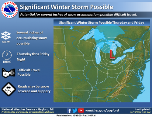
I have been watching the models the past couple days showing a storm system coming through the state wondering where the rain/freezing rain/snow lines would be as the models changed nearly every run. The main idea is that there will be a front coming through Thursday and Friday into early Saturday.
For the period Thursday through early Saturday, the frontal boundary will become nearly stationary over the area. Areas of low pressure moving along the front will bring occasional bouts of rain and snow, with some snow accumulation possible mainly north of a line from Muskegon to Mt Pleasant. A bit of freezing rain is also possible.
The ECMWF model shows an impactful snow event for most of the area Friday night with several inches possible through Saturday morning. That said it will not be a good travel period if this all plays out. Below is the thoughts of the Marquette office – the second is the NAM forecast. Stay tuned for later forecasts.
Cold air will move in after the front passes with chances of lake effect snow – bitterly cold air will move in on Christmas Day with high temperatures in the teens…
[columns] [span6]

[/span6][span6]

[/span6][/columns]
Today: Mostly sunny, with a steady temperature around 42. Southwest wind around 14 mph.
Tonight: Mostly clear, with a low around 25. West wind 8 to 15 mph, with gusts as high as 23 mph.
Wednesday: Partly sunny, with a high near 32. North northwest wind 3 to 8 mph.
Wednesday Night: Mostly cloudy, with a low around 23. East wind 3 to 6 mph.
Thursday: Mostly cloudy, with a high near 35. Southeast wind 6 to 9 mph.
Thursday Night: A slight chance of rain and snow showers before 1am, then a chance of snow showers. Cloudy, with a low around 31. Chance of precipitation is 40%.
Friday: A chance of rain before 1pm, then patchy rain, snow, and freezing drizzle. Cloudy, with a high near 42. Chance of precipitation is 50%.
Friday Night: A chance of rain and snow before 1am, then a chance of snow. Cloudy, with a low around 29.
Saturday: A chance of snow showers, mainly before 1pm. Mostly cloudy, with a high near 32.
Saturday Night: A slight chance of snow showers. Mostly cloudy, with a low around 19.
Sunday: A chance of snow showers. Cloudy, with a high near 24.
Sunday Night: Snow showers likely. Cloudy, with a low around 14.
Christmas Day: Snow showers likely. Cloudy, with a high near 18.
On the forecast page there has been a road hazards map which shows not only construction areas but also where the roads are snow covered or slippery.
[columns] [span6]

[/span6][span6]

[/span6][/columns]
The morning forecast discussion isn’t very promising. Sounds like the bulk of the snow will miss us to the north (freezing rain/mix here) with the first system, and the second one will miss us to the southeast.
I would cue up Stealers Wheel, but that is Jack’s job. 😁
Throw some wind in there with this storm we could be talking blizzard Friday now .. stay tuned .. INDYDOG..
Here in my area there is a lot of bare ground now showing. This could be a snow pile Christmas. That is a lot of bare ground but still snow piles around sort of like mid March.
Slim
Winter storm watches coming tomorrow night or Thursday morning for Friday .. stay tuned INDYDOG!!
RUFF….RUFF….,Indy DOG.
My guess is a Winter Weather Advisory. I don’t think we’ll be getting any heavy snows. It’s looking like a 1 to 4 inch snowfall. The system moving in will be somewhat weak, and the second one may very well miss us to the southeast. I don’t want that to happen though! 😛
I still have full snow coverage of around 3 to 4 inches!
Still about 5 inches of snow on the ground at my house and in my area (Fruitport/Spring Lake Township). The landscape is still mostly white in the Muskegon area outside of the normal commercial districts where it always goes first, along with areas where wind blew it away.
Check out this baby! No this winter not be like last year! Face the facts!
http://www.instantweathermaps.com/GFS-php/showmap-conussfc.php?run=2017121918&time=PER&var=ASNOWI&hour=384
Still have over 3 inches of snow on the ground out at thee YARDofBRICKS ready for a 10+ inches more Friday .. Thank you! INDYDOG!
We had a foot two days ago. All gone now except for the piles.
>>>>>>>>>>BREAKING NEWS>>>>>>>>>>>We will be getting hammered with COLD and SNOW starting this weekend and lasting for many, many days! ROCK n ROLL will never die!
But that’s what you said last week, and where is all our snow now??
Snow here melted really fast between yesterday & today.
Yeah, it went really fast. Doesn’t take long when the temps are in the mid 40’s approaching 50. We have a soggy mess everywhere!
Do you have any snow left down there, Sandy? Still 5 inches here.
ALL we have are the piles. You can see the grass every where. I would rather see the snow. Yesterday we went out walking & there was slush & some ice on the road but today all is gone. Looks like Spring out there.
HUURY SPRING 2018…….
Get ready all models are trending colder and snowier beginning Thursday! Can you say white Christmas!!!!!!!!!!!!!!!!!!!!!!
GREEN!!,, how’s That…lol….
Nice SUNSHINE Here In Allendale and 41degrees. Here Is The GVSU Cam Shot From The Allendale Campus. Which Is about 1.5 Miles EAST of The YARDofCUES ….
http://148.61.63.226/mjpg/video.mjpg
Let IT…Melt……Let It MELT……
Stay Cued….
A few areas in Michigan hit 50° today. Feels like spring. Car washes are super busy.
Gas jumped 50 cents. I paid $2.13 last night. $2.65 at most stations now.
Our garage faces south, and when the sun was out today it was 51 on that side of the house. Washed all my cars today outside, perfect day for it. I think they dumped more inches of salt on the road than inches of snow we received. the cars were just a mess!
Last of the 40’s for awhile darn 50’s where so close but no cigar … Get outside and enjoy it .. some models saying single digits for highs Tuesday get ready … INDYDOG!!
Well, the snow is pretty much gone. And I see upper 40’s in SE Michigan, wow. GFS has been trending warmer today in the latest runs.
Well it took a week or so to build our snow cover, and less than 48 hours for it to completely disappear. The yard and the fields are totally void of any snow now, just a muddy mess. At least I don’t have to mow?
Ohhh zeland did get snow .. only when it melts right?? Lol!! INDYDOG!!
https://www.accuweather.com/en/weather-news/where-in-the-us-is-a-white-christmas-most-likely-this-year/70003594
99.9% chance of a white Christmas in GR!
Possibility now 8-10 inches of snow coming Friday for Central Michigan have to keep a eye eyee sir on it INDYDOG!
Climatology for today December 18th At Grand Rapids, MI
The average H/L for Grand Rapids 34/23°
The record high is 55° set in 1926 the coldest maximum is 11° set in 1901
The record low is -5° set in 1926 and the warmest minimum is 39° set in 1939
The most precip is 1.03” in 2002
The most snow fall is 4.0” in 1951
The most on the ground is 13” in 1970
Last year the H/L was 21/12° there was 1.5” of snow fall and 8” on the ground.
Slim
The warm temperatures have taken a big toll on the snow cover here at house and now there are areas of ground showing and that should increase as the current temperature is now 44° here at my house and the last reading at GRR was 41° Not sure how much if any snow this area will have on Christmas but it sure is looking cold. IF the temperature stays below 20° it would be the first time since 2004 when the high here was 15° and here is a fun fact the coldest Christmas here in Grand Rapids without a… Read more »
A lot of the snow has melted here. It would be nice if we had a white Christmas.
It is too early to say one way or the other. But a white Christmas is not guaranteed. 4 of the last 6 Christmas have not had a snow cover here in GR
Slim
Look at how far the South the storm track will be starting from now. A track up to Northern Ohio would be INCREDIBLE!
http://www.wpc.ncep.noaa.gov/lowtracks/lowtrack_ensembles.gif
It feels like an early spring morning out there today as the snow continues to melt! If the GFS correct, we will see 3 or 4 cold days early next week before temps rebound significantly.
http://weather.unisys.com/gfs/loop/gfs_500p_loop.gif
Surely the CPC does not agree with the GFS! Also just 2 days ago the GFS had the storm for the end of the week cutting right through WI and giving GR rain with temps well into the 40’s and now the GFS shows the low pressure system going through Southern MI!
http://www.cpc.ncep.noaa.gov/products/predictions/814day/814temp.new.gif
http://www.cpc.ncep.noaa.gov/products/predictions/WK34/gifs/WK34temp.gif
Where are your posts about how it has changed towards MUCH colder with the most recent run?
IWS says friday afternoon low pressure tracks just north of Kokomo Indiana from west to east dumping heavy snow in central Michigan winter storm watches coming not sure yet on amounts … After that very cold air moves in!! Highs only in the teens for Christmas.. stay tuned on this major storm system coming to the great lks!! INDYDOG!!
Just the facts INDY – keep up the great work!
Well, well what do you know? The models are now trending colder and further South! No 50’s and now no 40’s! Who would have thought? Bring on a SNOWSTORM!!!