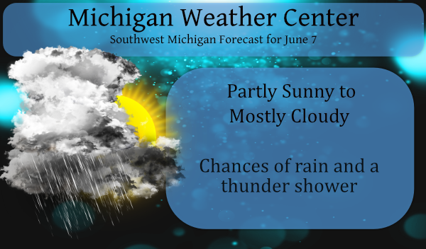
We had an overnight low of 71° after a high of 90° yesterday. Humidity levels are on the increase making the misery index outside moving into the uncomfortable range. The big question today is will we see some rain? There are some showers moving through Indiana from south to north, though not substantial the green blob on the radar does bring the hope of things to come.
According to the NWS southern Michigan has a 40% chance of rain mainly this afternoon mainly from popup showers and storms this increases to 60% tomorrow and 70% on Wednesday. Before we do our happy dance we have to keep in mind the NWS computer forecasts have been bullish on rain for several weeks.
We do have the ingredients in place to make rain possible, maybe even our first summer storms. Chances appear good to me much of which is explained in the forecast discussion below.
Forecast Discussion
- Scattered Showers / Locally heavy downpours most of week

We have forecasting the closed upper low from Texas to slowly
track into our area, for at least a week now. We have seen saying
you should expect scattered showers and isolated thunderstorms
from Mon through Wednesday last week. More recently we expanded
that to go into Friday.

The issues are facing is deep tropical moisture, very low vertical
wind shear, model sounding that look nearly saturated to near 300
mb, plus narrow cape to near 300 mb. This will likely continue
through most of this week. What this means for us is locally
heavy rainfall but no severe storms. We, at this point can not
pinpoint were exactly this will happen or when but this does seem
more likely than not. As you can read below, this system will be
around most of this week, so each day it will be the same thing
really. Deep layered clouds, scattered shower, isolated
thunderstorms and locally heavy rainfall (mostly in the mid
afternoon and early evening each day).

The glitch of course is that there is no surface reflection of
this upper level system. The center of the upper low gets to near
southern Lake Michigan, northern IN and northeast IL in the
Tuesday to Wednesday time frame. By Thursday it is likely be be
over OH. Due to deepening west coast trough and developing east
coast trough, this system gets stuck! A REX block (close upper
level high over a close upper level low) actually develops by
later Tuesday into Wednesday. This system has deep tropical
moisture with it. Precipitable water values are forecast to be in
the 1.8 inch to 2.0 inch range of most of our CWA by mid afternoon.
With the system stalled near us most of this week, that will only
slowly diminish as it slowly get rained out over the next 5 days.


- Brief spike in temperatures this coming weekend

Later this week, a strong lead wave, coming out the Pacific
system, will be heading in our direction. By Friday we should see
some shortwave ridging ahead of it. That will push the current
system out of the picture. However it is a dynamic system and will
likely bring more convection to this area later Friday or
Saturday. The shortwave ridging will bring a surge of warm to
maybe even hot temperature in the Friday/Saturday time frame. I
could see some highs in the 90s again.

- It may turn much cooler early next week

What happens next is this dynamic system will try to create a
fairly impressive deep trough over the central Great Lake by early
in the following week. If what actually happens is anything close
to the ECMWF (past 2 days of model runs) operational forecast,
trust me, it will get much cooler than the current forecast
models show. I could see highs only in the 70s Monday or Tuesday
if the ECMWF operational forecast is correct. The GFS is heading
it`s forecast solutions in the direction of the ECMWF and Canadian
is very much like the ECMWF. That being so, we get a break from
the warm/humid conditions early next week. There would be showers
around through if this all works out that way.

The bottom line to all of this is expect a lot of clouds,
occasional showers and warm temperatures into at least Saturday.
Will it rain? Yes, .6 inches here! Keep it coming!
Had a decent amount of rain here… seems over a half inch but I don’t have an official total.
Well we broke a tenth of an inch! 0.13” here.
It now has stopped raining here. Recorded 0.58″ of rain so a rather good amount this go around. At this time it is cloudy and 75 the Dew Point here is now at 69
Slim
Getting a heavy shower now, while not a drought buster it will keep the grass green and growing. It is a warm rain as it is now 77 with this rain.
Slim
Send it this way, would ya??
I recorded 0.58″ of rain and there is a flood adversary out.
Slim
Getting a little light rain here at this time. At this time it is 77 here with a Dew Point of 65.
Slim
“Summer” in the Southetn Arctic. Enjoy it while it’s here, as it takes nine months to arrive, and barely lasts 60 days. Sounds as though the cold could return next week.
Ahhh nope!
https://weather.com/weather/tenday/l/b4ea0280869baa46799dc75eacef8904785ec43ad2f6fb098355fbc208a55e2c
Facts baby! Summers are short and winters are long? Get used to it!
Dew point is now up to 71. Anything over 60 is just plain miserable.
No 90’s in sight for GR! Incredible!
I don’t know about you, but I am unable to tell the difference between 89 and 90. 🙂
It was another fantastic weekend at the lake. The humidity wasn’t bad and with the breeze, it did not feel too hot. The bass were biting like mad. Plus, we saw several painted turtles laying their eggs in the yard. That is always cool to see.
It is true that it is hard to tell much difference between 89 and 90. But 90 is just one of the bench mark temperatures that are used. I am sure you can not tell the difference between 33 and 32 or the difference between 0 and +1 but like said just a bench mark temperature. Now if it gets to 95 or 100 then one can feel the difference. So far this summer with the lower DP it has not been all that bad.
Slim
I’m with Mark on this one. I’m over the whole number of 90 degree days thing. We’ve had warm summers with few 90+ days and I’m sure we’ve had cool summers with many 90+ days. It’s an arbitrary mark that doesn’t really mean anything. Especially when we have a lot of 88-89 degree days.
Same can be said in the winter time anything below 20°F is cold and if the wind is blowing anything below 30 is cold.
Slim
But yet no 90’s in GR in June …INDY
The overnight low both here at my house and at the airport was a warm 73. The DP is up this morning so it is a little more humid then the past few days. While it has been warm this past weekend with the lower humidity and the breeze it has not felt all that bad. I worked on the years yesterday and it was not bad at all. If it stays dry I am sure it will soon change but for how dry and sunny it has been the grass (even in areas that do now water the grass)… Read more »
I see several locations hit 90 yesterday. Lansing has now had back to back 91 and 90 degree days. Kalamazoo has seen three: 91, 91, 90.
Remarkably, Traverse City and Alpena have been the hottest with 93, 92 for TC and back to back 94 degree days in Alpena. Wow!
Traverse City gets downsloping with a or south west or west wind and can get very hot at those times.
Slim
Phew 87, 87, 89 the past 3 days. Now comes the summer humidity!
Hit 90 here yesterday as well, but this morning feels far worse. The air is just thick with humidity and felt downright awful at 4 this morning already. Not a pleasant day working on tap.