We had a high of 81° yesterday with a 73° dewpoint and .05 of an inch of rain fell in the afternoon. Our overnight low was 61°.
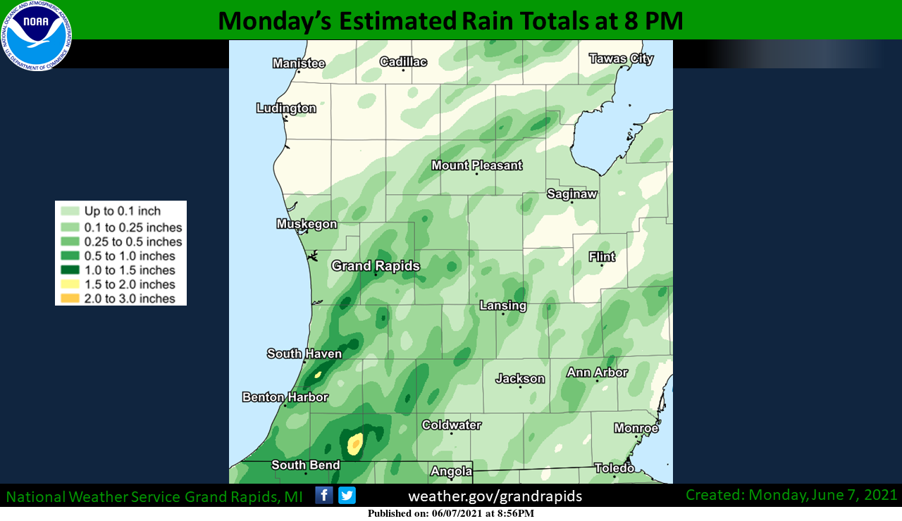
Ten miles away in Allegan they had .73 of an inch of rain which shows the frustration of hit-and-miss showers. This could make an interesting drought map come Thursday when the CPC updates it. Of course, we need many inches of rain rather than tenths to overcome the drought in Michigan.
Rain chances will continue through Friday as our moist airmass, thanks to a low-pressure center continues to meander to our south. Most areas from the I96 corridor to the south have a better than 50/50 chance of rain though they will continue to be of the hit or miss, popup variety. The SPC has us in the general storm outlook through Friday though we have no expectation of severe weather – having said that perhaps we will have an outbreak due to the opposite of expectations seems to hold true with weather forecasts 😳
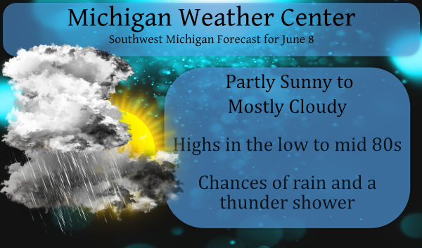
Showers will become more widespread by midafternoon today. Some locations may have a period of very heavy rainfall that may result in minor localized flooding. Highs today will be in the lower to mid-80s.
Forecast Discussion
- Areas of dense fog early today

Patchy areas of dense fog continued at 3 am this morning. The
dense fog is persistent along the lake shore, but not nearly so
persistent inland. Our night time fog IR image loop shows the
most persistent low clouds and fog is currently over central
and eastern lower Michigan. Surface observations show the dense
fog comes and goes even in those areas. The hi-res model forecast
for dense fog suggest we will not have persistent dense fog
expect near the lake shore this morning. Some of that may be
related to areas of mid clouds under the mid level deformation
zone are not allowing enough surface cooling. In any event at this
point I do not see a need for an inland dense fog advisory.

- Scattered locally heavy convection most of this week

As we have been writing about for several days now, we have a
largely stalled upper low near us. The air over us is very moist
to a deep layer, there is mid-level instability and all of this
persists into Thursday. Model sounding show the typical heavy rain
signature of narrow but deep cape, near saturated sounding to at
least 500 mb and the MBE vector speeds are mostly under 5 knots
into Friday afternoon. So afternoon heating convection will not be
moving all that fast but will have a lot of water to use of
precipitation efficiency.

One other issue to note through, as I have been writing recently,
we do have a REX BLOCK developing north of the upper low (which is
largely south of Michigan). Over time, a northern stream shortwave
pushes all of this to the southwest. That allows some dry air to
feed into northeast sections later in the period. This may push
the convection a little farther south each day through Thursday.

By Friday a northern stream shortwave tops the upper ridge and
slides southeast. This will enhance pushing the cooler and drier
Canadian air into our area from the northeast. Even so we have a
decent deformation zone over us by then and still have deep
moistures so no reason for convection to stop then.

- Warming this weekend only to cool early next week

Over the weekend that strong Pacific system I have been writing
about for several days pushes a shortwave ridge into our area
Saturday. That will warm things up. However there is decent
dynamic forcing so convection will continue even so.

Finally that system pushes through but if the ECMWF is correct we
end up with a closed upper low over Michigan on Monday with cooler
air but still convective instability. Maybe by Tuesday this will
push off the east and we will finally clear. It will be cooler the
beginning of next week and if the ECMWF is correct it will be
much cooler.
It’s great some good down pours are happening across kent Ottawa in Allegan countys let’s hope we get some here in my area soon put to rest the drought mess ….INDY
A little thunder and rain here.
+5.3 degrees above average for the first week of June. Phew!
Thats ok with me just keep the 90’s out of sight starting to see some 70’s show up next week even better!!! Shuuuu!! INDY
No 90’s and a cold front is upcoming! I love it!
Over here about 3 miles north east of Grand Junction had a little under 1-1/2 in yesterday. Thunder and lighting right now.
Nice! If you’re lucky enough to get underneath one of those pop-ups, they’re putting down some serious rain. Only a few sprinkles earlier today. We did get a five-minute torrential downpour late yesterday afternoon. We need some more of that.
Just over 3 tenths of an inch for us yesterday. Sad thing is that was probably our biggest rainfall in a month or 2. Crazy thick air. At one point yesterday the dew point hit 73. Can’t wait till we get some drier air.
I had 0.20 here in Comstock Park. Garden looks happy but would like more. Hopefully today.
Thank goodness yesterdays once calling for a high of 93* degrees never happen I wll take rain and clouds over heat any day of the week but now everything is damp so get ready for mosquito season ….INDY
No 90’s in sight, despite the incessant warm weather hype! Bring on more rain and then a cold front by the end of the week! Who would have thought? Incredible!
Well I believe the term heat wave means hot weather not mid 80’s or uper 80’s….But then again it could be my meds I’m supposedly taking lol….YES no 90’s insite that’s fantastic news thank you!! INDY .
Some terms used by the National Weather Service as to “heat” Heat Advisory Issued within 12 hours of the onset of the following conditions: heat index of at least 105°F but less than 115°F for less than 3 hours per day, or nighttime lows above 80°F for 2 consecutive days Heat Wave A period of abnormally and uncomfortably hot and unusually humid weather. Typically a heat wave lasts two or more days It is ones perspective as to what is uncomfortable. To some it could be 90 to 95 or more to others it might be 85 or even less.… Read more »
Good observation Slim ..let me know when the mid 90’s are coming that’s hot weather in my books I wll agree on calling it a hot wave then .I mean heat wave ….INDY
I recorded 0.63″ of rain fall here at my location yesterday. The heavier rain fall was not widespread the official amount at the airport was 0.46″ at Muskegon 0.08″ at Kalamazoo 0.19″ Holland and to the east at Lansing just just 0.05″ fell. The overnight low here at my house was 67 and at this time it is cloudy with some light fog and 68 with a Dew Point of 67.
Slim