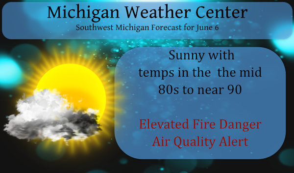
Yesterday we had a high temp of 88° and our low is 66° this morning. Our last measurable rain was on May 28th (these are Otsego/Plainwell stats).
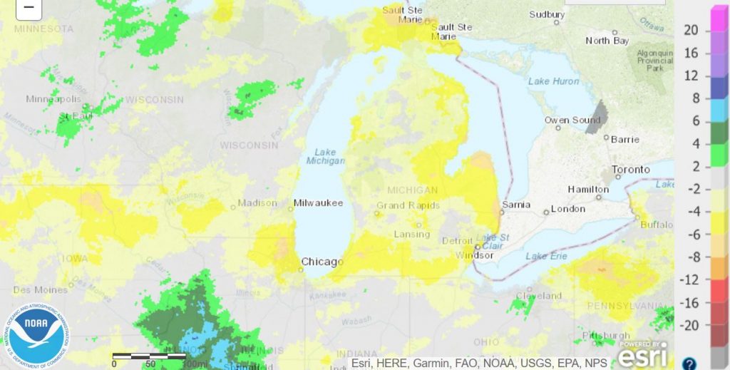
Below is a graphic of our departure from normal for precipitation this year. Most of the state is 4 to 6 inches below normal.
The following is an article from Climate Action written ten years ago. The article explains why we can have hotter days during periods of drought.
For the first time, a group of scientists has assessed the global connection between soil moisture and heatwaves. They have shown conclusively that precipitation deficits increase the likelihood of hot days, which may help assess heat risks in areas of the world.
The general trend is that if there is low precipitation in the spring, there is more likely to be a hot period in the summer. Water levels in the soil are essential because moist air prevents the atmosphere from heating up as quickly as dry air. Water has a high specific heat capacity, meaning it takes more energy to heat it than it takes to heat dry air. Once the moisture has gone from the soil, however, the temperature will rise considerably.
The study showed that this was most prevalent in the Americas, Europe, Australia, China and Japan. Not only this, but it also showed that the phenomenon has most of its impact during the most extreme temperatures. The probability of these heatwaves occurring doubles in some regions after precipitation deficits.
“We knew that in some regions soil moisture greatly affected the number of hot days, because we had shown this in other studies; for example, in southern Europe. However, we did not expect this to be the case in so many regions,” says Sonia Seneviratne, who co-authored the study at ETH Zurich.
There are exceptions to this trend, however, with the author citing the Swiss summer of 2011, where a dry spring was followed by a wet July and cool August. The increased likelihood of heatwaves is a probability calculation, not a weather forecast, so whilst meteorologists can use this information to improve forecasts, on its own, it can only show a probability of heatwaves increasing.
There is little chance of rain today, we don’t have the humidity or lift mechanisms in place to fire up storms. Chances tonight through Friday as our humidity rises which may increase the likelihood of popup storms – something we haven’t seen in quite a while. Gulf moisture will be feeding into the area by tonight so hopefully, we can have chances of much-needed rain over the next several days.
Forecast Discussion
- Wild Fire Danger Today; hot, dry, breezy

Today will be the last of our string of mostly sunny and warm
days. Today is likely to be the hottest day of the year so far.
It will be breezy yet too, so given how dry it has been, the risk
for rapidly spreading wild fires remains for one more day.

We have an upper low that has been over Texas for most of this
past week. The system is now getting sheared out of Texas by a
fairly strong Pacific system this is moving on shore of our west
coast today. The system being lifted out in the short term
increases out mid and upper level heights and this in turn
increase our thickness values. The increased ridging over us will
keep today dry. The subsidence from the building ridge over us
will keep result in our highest, daily high temperature of the
year, to date. Many location inland of Lake Michigan should have
highs in the lower 90s today. Helping the cause for this will be
deeper mixing caused by the approching system.


- Daily Convection into Friday, locally heavy rain possible

The upper low gets close enough tonight to surge in deep
moisture. The precipitable water values increase from under and
inch this afternoon to nearly 1.8 inches by midnight tonight.
This is a result of that upper low heading this way. This leads to
a narrow band of rapidly increasing precipitable water values
heading northeast into Southwest Lower Michigan by evening.
Typically there is a band of showers (thunderstorms) moving along
with this feature. Just about all of our high- resolution models
agree with this idea too. Model sounding become nearly saturated
to 300 mb by midnight, over our area. So do not be surprised by a
brief period of showers this evening as this moisture surge area
moves into our area from southwest this evening.

Once the upper low gets into this area it will get stall here for
most of the week, as it gets sandwiched between the upper ridge
to the east, the polar jet to the north and developing western
trough. It seems likely areas near and east of US-131 will see
showers and thunderstorms Monday, mostly in the afternoon. The
HRRR is showing band of 1.5 inches of rain in 3 hours at that
time. Given the weak wind field in place at that time and how wet
the air is, that would actually make sense. The lake breeze
convergence boundary could be a focus for that convection Monday,
Tuesday and Wednesday. There is not enough shear for severe storms
but there is enough water in the air for locally heavy rainfall.
This would seem to be our focus this week, figuring out where the
locally heavy rainfall will actually be.

It had for awhile looked like this system would be gone by
Thursday but not it does not look like that now. Seems we need a
lead shortwave from that developing western system to shear this
system out of the area. That seems to now be in the Friday time
frame. Thus expect a similar weather pattern most of this week,
afternoon and evening convection, warm and humid otherwise.

- Weekend could be wet or dry

Well then what? The ECMWF yesterday had what we through was an odd
solution in that it took that lead wave and really deepened it. By
early in the following week it had a 557 dm 500 mb height, closed
upper low over Detroit by Tuesday of the following week. Wow,
that would be cold and wet for sure. Now through, we have that
lead wave coming through this weekend. The question becomes how
this plays out. It would seem we would get some showers when it
comes through during the weekend of the 12th. Timing is
questionable through. Once it comes through, how much does it
develop and where does it develop, if it does?

So, if it focus east of there, we are hot and dusty through a
good part of the following week. If on the other hand it is not
quiet so far east, we could be cool and wet. It`s to early to say
how this will really play out.


It is great to see that the cpc now gives us normal temps starting by the the end of next week! Incredible!
Despite the constant warm weather hype, GR could not even hit 90 degrees and no 90’s are in sight! What a joke! The warm weather nuts are out of control!
After today’s possible 90* degrees I see the temps have come down the rest of the week with more chances of rain thats the best news of all this Sunday morning!! Loving the 70’s along lake Michigan taking advantage of them this weekend have a good Sunday …INDY
Thanks for the read MV. Hard to break this kind of pattern as it continues to get drier and drier and temps keep going up. Unbelievable high temps yesterday to our west! 100’s in the Dakotas, 97 in Winnipeg up in Canada. We’re only 6 days into June!
Weather patterns in our area tend to change every 45 to 70 days. Some are shorter few are longer. But between now and the end of summer there could be a pattern change.
Slim
To a point that’s true with short term changes. But long term patterns seem to persist for months, even years. For example last year we were stuck in a pattern with a lot of rain all year. Record rain for that matter with the big lake levels rocketing up. Now this year since January it’s been a complete flip. Almost 6 months of near record lack of rain, well beyond 45 to 70 days. Every week we hear the promise of rain and every week we squeak out a hundredth or two of an inch of rain.
Looking far out into the fall, a drought can also impact the leaf change and harvest. But we will worry about that when the time comes (have to enjoy summer first!)
Very good information on soil moisture and potential heat waves. While GR has had a couple of very warm days with highs in the upper 80’s with the wind and lower humidity it has not been all that bad and most felt nice out. And while the air has been on it has not been running all that much yet. We took a trip to the beach at Muskegon yesterday and at the beach area the temperature was just 67 between 2 and 5 when we were at the beach area. About 3 miles inland it was in the mid… Read more »