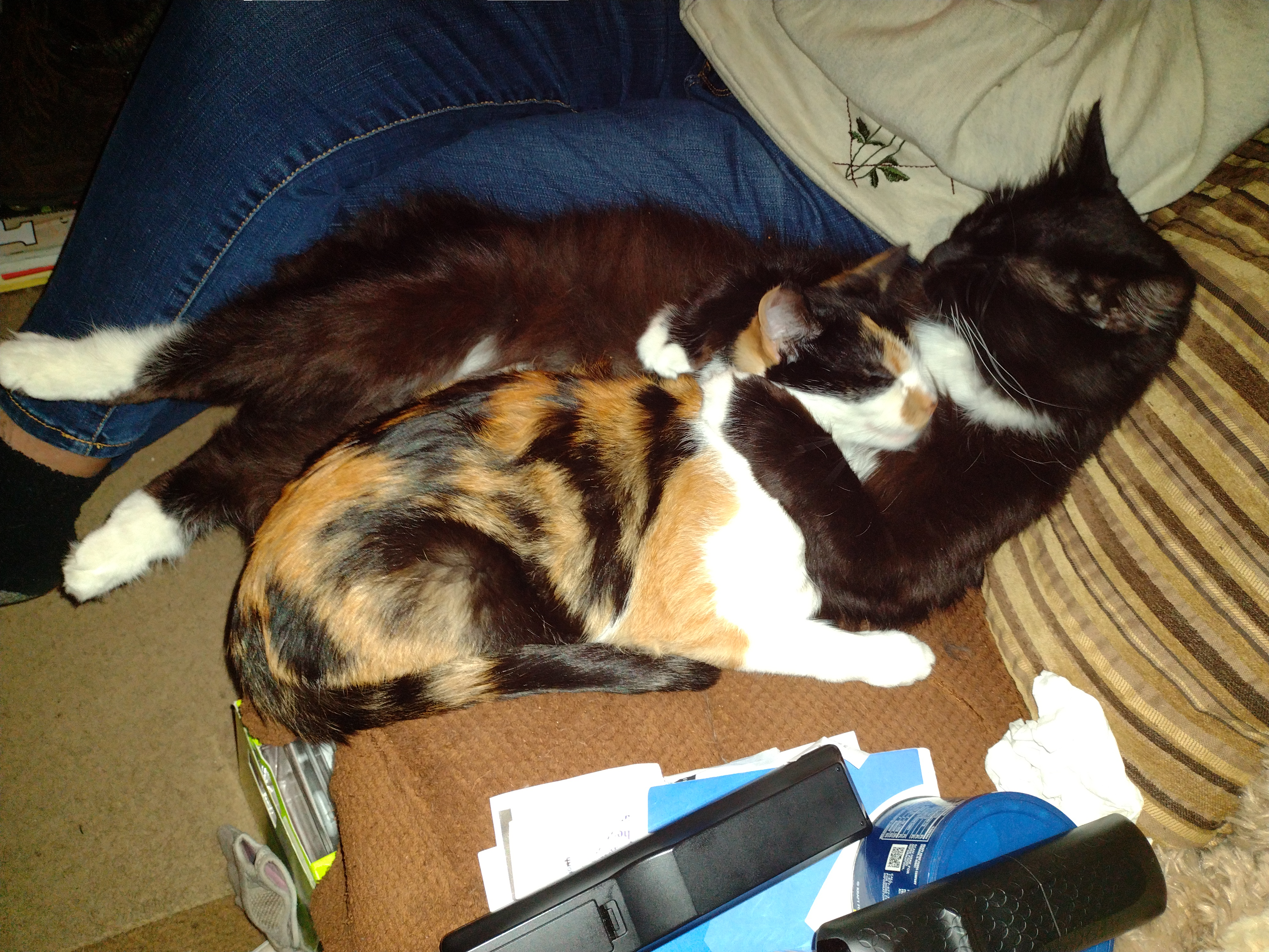
Another month has come and gone and we firmly place our feet into the first month of meteorological winter. Two of my cats have the right idea of a long winter’s nap. This is Monster and the youngest member of the family Maizie. Monster is the big black one, he adopted Maizie soon after we brought her home as a rescue cat several months ago. They are pretty much inseparable.
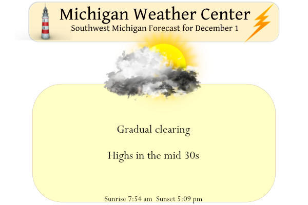
Today will be calmer than yesterday with gradually clearing skies which will be welcome after the windy day yesterday. The high was 55° at midnight and quickly fell to 28° which was our low for the day.
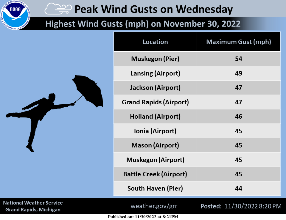
The winds on Wednesday were much colder and stronger than the winds that occurred on Tuesday. Take a look at the highest reported wind reports we received.
Forecast Discussion
Forecast concerns deal with precipitation Friday night ahead of the
next cold front.

Water vapor imagery shows the short wave that moved through
yesterday is now moving across NY/PA. In its wake is ridging which
has caused the lake effect snow showers to end; radar is pretty much
devoid of echos at present. IR loop shows lake effect clouds are
still present, however, but they too will thin out this afternoon.
So, we`re looking at a dry day and a half until the approach of the
next cold front later Friday.

A short wave crossing the Rockies will develop a lee cyclone over
the Dakotas before it moves northeast across the western Great
Lakes. Condensation pressure deficits begin falling around 21z
Friday but don`t really crash until closer 00z Saturday, which is
when we should see rain develop across the western cwa and then move
east; boundary layer temperatures are a bit too warm for snow ahead
of the front. Fropa occurs around 06z after which any lingering
precipitation will turn to a brief period of light snow. A brief
period of lake effect snow will probably develop Saturday morning
over the western cwa, but will be short lived and any accums will be
less than an inch.

High pressure quickly moves across the MO/OH Valleys Saturday night
and Sunday ahead of a clipper moving across Ontario. This system
looks like it will remain far enough north of the cwa so that we
will remain dry.

Models show a southern stream wave trying to merge with a northern
stream wave on Monday which may produce some light snow across west
MI and that would likely linger into Tuesday.

Thus, we have several chances for light snow as well as some light
rain over the next few days, but no significant accumulations.
Yrahh thats what they said about November not that much snow lol…INDY
Some said very little snow and above normal temps and what did we get!? Way above normal snow and near normal temps! How wrong could they be?
>>>>>Breaking Weather>>>>>the last half of December will be cold and snowy! Take it to the bank!
Storm track is looking good over the great lake state yeahhhh …INDY
Perfect start to December. The CPC gives us a below normal temp month and the RDB gives us tons of snow! Wow!
Looks cool but maybe not all that much snow fall.
Slim
Matt Kirkwood says he believes there is an excellent chance of a white Christmas this year. We shall see.
Finally someone is looking at the long range trends, teleconnectors, jet streams, moderate La Niña, etc! Bring it on!
Perfect start to December, sunny and green.
The first half of December looks like it may be cooler than average but also dry. So not really much snow fall at this time.
Slim
Sounds good to me. I can handle any temps as long as they’re below 75. Perfect wood cutting weather as long as it continues to stay dry.
Cute cats MV! I have a cat of my own. She’s only about a year and a half old
My cat likes to take her naps by the heat register in the living room.
Slim
A brief recap of meteorological autumn. At Grand Rapids the 3-month mean was 51.7. The 30 year mean is 51.6 so at Grand Rapids the temperature was very near average. Note that most other locations in lower Michigan had departures that were warmer than Grand Rapids. The highest reading in fall of 2022 was 85 on September 3rd and the lowest reading was 18 on November 19,20 and 22. There was a total of 7.37” of rain and melted snow fall that was well below the average of 10.55” There was 28.0: of snow fall and that was well above… Read more »
Welcome to meteorological winter! Yesterday’s official high of 54 occurred just after midnight and the temperature dropped all day. The low of 26 occurred just before midnight. There was 0.06” of precipitation of that a trace was snow fall. There was no sunshine yesterday. The temperature has held steady overnight and the current temperature here is 27. For today the average H/L is now at 41/28 the record high of 65 was in 1970 and the record low of +6 was in 1976. The record snow fall amount is 5.0” in 2010. This past November had a mean of 40.9… Read more »