I thought I would put up a post on weather satellites to finish out the year. Our technology since the 1960s when I followed the space program with great interest from the Atlas and Saturn space programs has vastly improved from the early anolog to digital control systems. I am a model builder which began with ships and the early Atlas Rocket, a huge space shuttle with all the boosters, an early space capsule, and soon a large Saturn rocket. If you have ever been to the Air Zoo near the Kalamazoo airport you have seen the early space capsule from the Gemini program which had just enough space to cram an astronaut – brave men who road those rockets into space in those days.
The world’s first meteorological satellite was launched from Cape Canaveral on April 1, 1960. Named TIROS for Television Infrared Observation Satellite, it demonstrated the advantage of mapping the Earth’s cloud cover from satellite altitudes.
First television picture from space. TIROS-1 Satellite, April 1, 1960. First television picture from space. TIROS-1 Satellite, April 1, 1960.
TIROS showed clouds banded and clustered in unexpected ways. Sightings from the surface had not prepared meteorologists for the interpretation of the cloud patterns that the view from an orbiting satellite would show.
TIROS was a polar-orbiting satellite, meaning the satellite orbited in a latitudinal motion, which took it over the North and South Poles. Today, polar-orbiting satellites round the Earth 14.1 times daily.
Since the number of orbits per day is not a whole number, the orbital tracks do not repeat on a daily basis. Currently in orbit are morning and afternoon satellite passes that provide global coverage four times daily.
The advantages of polar-orbiting satellites:
- Closer to the Earth, with an orbit of about 520 miles (833 km) above the surface, thus providing much more detailed images.
- Excellent views of the polar regions.
The disadvantages of polar-orbiting satellites:
- Cannot see the whole Earth’s surface at any one time.
- The path of each orbit changes due to the Earth’s rotation, so no two images are from the same location.
- Limited to about six or seven images a day since, most of the time, the satellite is below the Earth’s horizon and out of range of listening equipment.
Go to the Alaska Aviation Weather Unit page for images from the polar-orbiting satellites and the NOAA Satellite and Information Service (NESDIS) for the tropical regions.
Geostationary Satellites

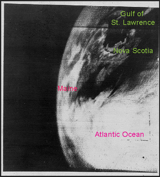
NASA image from ATS-I, December 11, 1966, the first geostationary satellite. North America is in the upper right (Baja California most noticeable) and South America is located at the far bottom right.
The first geostationary satellite was launched in 1966. Unlike polar-orbiting satellites, geostationary satellites orbit at a much higher altitude of 22,236 miles (35,786 km). Positioned over the equator, the satellite completes one orbit in 24 hours, meaning it orbits in sync with the Earth’s rotation. The net result of this timing is that the satellite appears stationary relative to the Earth’s surface, allowing it to hover continuously over one position on the surface.
Early geostationary satellites were “spin-stabilized”, meaning they maintained stability by rotating and, therefore, viewed the Earth only about 10% of the time. Current satellites are now stabilized in a way that allows them to always view the Earth. These current satellites are called Geostationary Operational Environmental Satellites (GOES).
Because they stay above a fixed spot on the surface, they provide a constant vigil for the atmospheric “triggers” for severe weather conditions such as tornadoes, flash floods, hail storms, and hurricanes.
Geostationary satellites are the bread and butter satellites for the meteorologist. Their advantages are:
- They are always located in the same spot in the sky relative to the Earth.
- They view the entire Earth at all times.
- They can record images as frequently as once every minute.
- Since their view is always from the same perspective, the motion of clouds over the Earth’s surface can be measured.
- They can receive transmissions from free-floating balloons, buoys, and remote automatic data collection stations around the world.
The disadvantages of geostationary satellites are:
- Their high location, at 22,300 miles (35,000 km) above the Earth, provides lower-detailed views.
- Views of the polar regions are limited due to the Earth’s curvature.
Moving Geo”stationary” Satellites
Even though GOES satellites are stationary relative to their position over the Earth, that position can and does get moved. As newer satellites are placed in orbit, older versions are moved into storage positions where they can be called upon again if needed.
As such, these satellites have rocket engines to move them, but not likely in the way you may think.
The farther out from the center of a rotating object, the faster the speed needed to “keep up”. GOES satellites orbit at a constant speed that matches the Earth’s rotation at their particular distance from the surface. As a result, if this distance were less, then the satellite’s unchanging speed would cause it to orbit faster relative to the Earth’s rotation. An orbit at a greater distance would be slower relative to the Earth’s rotation.
If the satellite is orbiting faster relative to the Earth, then the point over which it appears would move east. A slower-orbiting satellite would appear to move west over the Earth.

This is the method for moving these “stationary” satellites: the rocket engines do not change the actual speed but move the satellites closer or farther away from the Earth, altering their relative speed. When they are in the desired new position, the rockets are fired again to return them to the distance where they appear “stationary” again.
GOES-R Series
In November 2016, the newest geostationary satellite, GOES-R, was launched. After undergoing a year of testing, it was designated GOES-16 and placed in operation located over 70ºW longitude. Also known as GOES-East, this satellite marks a vast improvement over the previous aging GOES satellites.
The next GOES-R series satellite was launched March 1, 2018. After testing, it was designated GOES-17 (GOES West) and currently operates over 137ºW.
Both GOES-16 and GOES-17 will cover the Weather Hemisphere from the West coast of Africa to as far west as New Zealand. Two additional GOES-R series satellites will eventually be launched to help provide dedicated service through the year 2036.
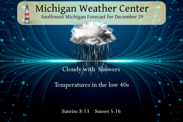
Forecast
Forecast Discussion
Continued low-level troughing and lift over southern MI and
IN/OH, underneath the resident upper-level low, will maintain low
clouds and occasional drizzle or light rain showers through this
evening. Most of the showers will be south of a Muskegon to Mount
Pleasant line and trend south with time. The upper-level low will
finally get kicked out to the coastal Atlantic tonight, and we
will see shortwave ridging tonight until the next low approaches
from the northwest late Saturday.

Skies may partially clear prior to sunset today around US-10, and
this partial clearing should move southward early tonight. This
may help temperatures dip below 32, but right now the concern for
icy pavement is pretty low as the surface air will probably be dry
enough with just enough wind to favor evaporation off pavement,
especially if clearing is short-lived.

The latest HREF member models bring less optimism for sun on
Saturday. Certainly they are more pessimistic than the ECMWF/GFS
ensembles have been. The HREF shows the moisture contribution from
Lakes Superior and Michigan may be enough to maintain clouds in
the 1000 to 2500 ft layer, which would be trapped under the mid-
level subsidence inversion. This does make sense given the time of
year, as would putting more stock in the HREF than the global
models for this matter, so will call Saturday partly sunny instead
of mostly sunny. Still, if we manage to see more than 21 percent
of possible sunshine at GRR (two hours of sun), it would be our
sunniest day since December 15 (80 percent of possible sunshine).

.LONG TERM...(Saturday night through Thursday)
Issued at 325 AM EST Fri Dec 29 2023

Not much has changed regarding the system which comes through on
Sunday and Sunday night. Sfc and upper lows cross the state but
model QPF continues to be rather light; mostly under a tenth of an
inch.

While snow will be the preferred p-type as we end 2023 with H8
temps around -7C, the light precip rates and warm ground will make
it tough to accumulate much snow, and generally only a dusting on
the grass is anticipated. The light synoptic snow ends later
Sunday night although some light lake effect snow could linger
into early Monday along the coast with northerly flow.

Dry weather is forecast Monday and Tuesday as ridging moves in
aloft behind the departing upper trough. A tightening sfc pressure
gradient on the periphery of a large sfc high moving from the
Central Plains to the TN Valley will promote breezy conditions on
Tuesday with temps back up around 40 degrees.

Another upper trough arrives from the west for Wed-Thur and helps
drag a sfc cold front through. QPF with this system looks light
too and temps remain above normal so any impacts would probably be
minimal.
Or here for Rocky..
https://northernontario.travel/northeastern-ontario/complete-guide-moosonee
Perfect weather for you..
https://weather.com/weather/tenday/l/Moosonee+Ontario+Canada?canonicalCityId=fdb06a9b12e6f3b8ff0d3c57a80f95a762cb80769f4fb94b90c718992f0560d8
Perfect city for Rocky!
https://www.accuweather.com/en/ca/peawanuck/p0l/daily-weather-forecast/2288915
Still don’t understand why Rocky does not move to Canada? Tons of cold and snow, Socialist Authoritarian government and very strict Covid and Anti Gun laws. That would seem to be his paradise.
And another Rocky swing and miss wishcast, I marked it down, LOL!!
Rocky (Rockford)
No doubt and I see a major snowstorm by the 3rd week of December! Mark it down and get ready!
December 2, 2023 10:12 am
Whoops! So many incorrect forecasts it’s tough to keep track of them all.
Too funny! Seventh warmest year on record here in GR! According to the CPC, which has been incredibly accurate this year, the warmth will continue well into January!
Here’s a perfect example of a Bill Steffen wishcast earlier this month:
Kyle (Portland, Ionia County)
From Bill Steffen just the other day and also alluded to this a bit this morning:
“Looks like December starts on the mild side with temperatures a touch above average for the first 2-3 weeks of the month. It looks to me like we’ll see a turn toward a colder pattern around or shortly before Christmas and January could turn out to be a chilly month.“
December 2, 2023 8:50 am
Fantastic find! These WOOD meteorologists are notorious for wishcasting 3 weeks out. Whoops!
Kirkwood is by far the worst of the wishcasters!
What? Long range forecasts change and evolve over time? Who would have thought? It’s almost like it’s weather or something!
Rock on Kyle and keep the facts coming! They do not understand long range outlooks! Who knew?
Lol!!! Hilarious swing and a miss again on the December prediction!! Woodtv said this will be the second warmest December of all time for GRR.
Rocky (Rockford)
The rest of December will not be mild and if you are taking bets, I will bet you any amount of money you care to risk that GR will receive more than 40 inches of snow! I do accept credit card payments!
December 5, 2023 2:25 pm
El Niño pattern continues the next 2 weeks (at least)… not much to talk about here. Bill seems convinced it will change mid-January, we shall see!
Total wishcast from Bill.
Spot on Nathan. Even Matt and Sara Flynn on the noon newscast said it looks like things change around Jan. 10.
Yes, all of the teleconnectors are trending towards colder and snowier, so no not a wishcast, just reporting the facts baby! Bring it!
Not really…

LOL CPC proves that is a lie.
My brother texted me a photo wed. from his place in the Ishpeming area where he had around 300 inches last year. There’s not a hint of snow on the ground there. He’s loving it.
An ice fishing report showed no safe ice in central UP too. Most was 3” of soft spongy ice. Crazy year.
I talked with a friend in northern Wisconsin and he said the same. No one has dared to venture on the ice yet this year.
Who would live in west MI and not want snow this time of year? Winter rocks and we will see multiple snowstorms this winter! Get ready!
You consider an inch of snow a snowstorm, so we may get a couple of those this winter still.
This is my kind of post. Nicely done, MV.
We were at Van Andel yesterday to watch the GLI. My wife’s cousins played in the MSU v Ferris State game. Brother v brother, one on each team. We had a bunch of family there and we had a great time. MSU prevailed 4-1 but Ferris’ lone goal was scored by cousin Travis Shoudy. Even though Ferris lost, Travis got the bragging rights.
I saw Kirkwood tears due to the fact of no snow and horrible winter conditions. What could be better than low furnace bills, short winters, and easy commutes? I love it!
When Kirkwood is in tears, it means fantastic weather!! Keep the tears flowing!
Great information on some weather satellite history. As stated we have came a long way.
Slim
The official HL yesterday at Grand Rapids was 44/38 there was 0.17” of rainfall there once again was no snowfall. The also was no sunshine. For today the average H/L is 33/22 the record high of 65 was set in 1984 the record low of -4 was set in 1909 that year also had the most snow OTG with 14”. The wettest was the 1.38” that fell in 1990 the most snowfall of 5.8” was in 1980. Last year the H/L was 54/40 the day started with 8” of snow OTG.
Slim