Temperatures will remain cool but still a little too warm for snow. Occasional drizzle or rain showers will continue into Friday as a slow-moving low-pressure system lumbers through the region.
It seems the Detroit office keeps more elaborate records than Grand Rapids. To be fair a lot of storms form east of Grand Rapids during these events. This is part two continued from yesterday.
A disorganized area of showers and some embedded thunderstorms tracked into southeast Michigan during the late morning hours of April 1st, 2023. While the overall environment was marginal owing to a lack of instability, locally favorable conditions for severe weather developed south of I-94 as upper and low-level features briefly interacted. The thunderstorm complex reinvigorated between 10 and 11 AM, eventually becoming severe for a brief period over Lenawee/Monroe/southern Wayne Counties. These storms produced damaging wind gusts, sub-severe hail (spotters reported up to M&M size), and a brief/weak EF-0 tornado in Dundee. The tornado was on the ground for 5 minutes, causing damage consistent with 80 MPH wind gusts as it tracked through the heart of downtown Dundee. By noon, storms had shifted into Canada and the severe weather threat was over.
On the late afternoon of June 15th, a localized area of low pressure coupled with favorable upper-level dynamics produced numerous showers and thunderstorms mainly south of I-96. The prevailing atmospheric conditions accelerated the intensification of the storms, producing several strong to severe thunderstorms. Hail, measuring 1-2 inches, emerged as the primary severe weather threat, with several instances of wind damage associated with gusts around 60 mph. Notably, an EF1 tornado developed just west of Lake Erie. This tornado, which remained on the ground for 9 minutes, exhibited a maximum wind gust of 90 mph. In its wake, damage was reported which included multiple large fallen limbs and trees, along with damage to several residential properties.
A line of severe thunderstorms tracked across Lower Michigan during the afternoon and evening of June 25, 2023, producing widespread wind damage across the state. These storms were part of a bigger system that resulted in nearly 1,000 reports of severe weather across the eastern United States that day, including tornadoes in Indiana, Kentucky, and Arkansas. Locally, storm damage was consistent with 50 to 65 mph straight-line wind gusts for most areas. Parts of Romulus, Dearborn, and Hazel Park were reported to have localized stronger downburst wind gusts. Close to 80,000 customers lost power across the state due to the damage.
Scattered severe thunderstorms began to develop across northern portions of Southeast Michigan in the early afternoon of July 11, 2023, as a strong cold front sagged southward across the area. Severe thunderstorms continued to impact parts of the area as storms moved eastward before diminishing in the early evening as the cold front moved out of the area. Damage from straight-lined winds included numerous large tree limbs and power lines down. Mid-level rotation was indicated on radar which led to a tornado warning and a wall cloud was reported near Mayville, Michigan. This isolated storm also produced one-inch hail in Vassar, Michigan.
An outbreak of multicell clusters and supercells developed across Southeast Michigan on the afternoon of July 14, 2023. These storms produced areas of wind damage, large hail to golf ball size, heavy rain, and an EF0 tornado in Sanilac County before moving eastward into Canada and the lakes during the evening. Numerous trees were downed across the region, and in the Thumb, there were several reports of destroyed corn and wheat fields as well as several homes with damage to siding due to wind-blown hail.
A combination of squall line thunderstorms tied to a strong cold front and pre-frontal supercells brought severe weather to parts of Southeast Michigan Thursday afternoon and early evening on July 20, 2023. In total, 12 Severe Thunderstorm Warnings and 6 Special Marine Warnings were issued. One supercell that developed just before the arrival of the squall line produced 2.75-inch (Baseball size) hail over Davison, MI leading to widespread hail damage to vehicles, homes, and businesses. This was the largest hail reported since a supercell moved through Hudson, MI on June 20, 2021, producing 2.75 to 3-inch (Baseball to Large Apple (size) hail. Several other locations also received severe hail, including Ypsilanti where 2-inch (Lime size) hail fell and Ann Arbor which experienced 1.5-inch (Ping Pong size) hail, shutting down the Ann Arbor Art Fair for a couple hours. Additionally, there were numerous reports of downed trees (some of which fell on homes), several measured wind gusts in excess of 50 mph, and a waterspout over Anchor Bay.
A line of thunderstorms developed ahead of a frontal boundary and moved across Lake Michigan during the morning hours of July 26, 2023. These thunderstorms would eventually track across the state into a very warm and unstable environment, which promoted the issuance of a Severe Thunderstorm Watch for all of southeast Michigan. The southern end of the line of storms is where the strongest winds associated with the line would develop and move across the lower portions of southeast Michigan during the afternoon between 2 PM and 5 PM. A swath of widespread 60-70 mph wind gusts with locally higher gusts resulted in numerous downed trees, downed powerlines, and around 165,000 power outages in southeast Michigan. The Ann Arbor and the Detroit/Grosse Pointe areas were hit the hardest.
Numerous showers and thunderstorms filtered in across portions of Southeast Michigan through the evening of August 11, 2023. The strongest storms were found within the vicinity of or along a warm front, which produced sporadic reports of hail up to an inch and some isolated damaging wind gusts. Prolonged heavy rainfall also led to flooding within Flint which led to multiple road closures. The most significant damage came from a supercell over Perry, MI, which resulted in the production of an EF-1 tornado with maximum wind gusts up to 95 mph. This tornado was on the ground for 12 minutes and started just west of Perry, before moving into the city. Uprooted and sheared trees, damage to outbuildings, and some siding/shingle damage to residential builds were observed. Downed trees also landed on some residential houses and vehicles, resulting in further damage.
August 24, 2023 Early Morning Flooding & Severe Weather
Thunderstorms producing torrential rainfall led to flash flooding in the Detroit metro area early Thursday morning. Western Wayne County into Monroe County was hardest hit resulting in widespread residential flooding, road closures, and stranded vehicles. Most notable was the closure of Dingell Drive at Detroit Metro Airport which cut off access to the McNamara terminal for several hours. A lengthy closure of I-94 at I-275 was also reported. Numerous rainfall totals in the 3 to 5-inch range were reported mostly in the 6-hour period from midnight to 6 AM. The highest total was 7.36 inches from a CoCoRaHS station in Belleville, a 24-hour total nearly all of which fell during this event.
August 24, 2023 Evening Tornadoes & Severe Weather Event
…Most tornadoes in a single day during the month of August…
…6 tornadoes impacted Southeast Michigan, with 7 tornadoes statewide…
Rapidly developing thunderstorms begin to pop up over Central and Southwest Lower Michigan by the early evening hours of August 24th, with exceptional moisture and instability in place over southern Lower Michigan. The storms quickly grew upscale and became severe, leading to a west-east line of severe thunderstorms which dropped south through southeast Michigan during the evening hours.
Strong winds in the mid-levels allowed for damaging winds to be the primary hazard, with areas of southeast Michigan seeing 60-80 MPH wind gusts which led to extensive tree damage and power outages. At the peak, close to 500,000 customers lost power in southern lower Michigan. A surface low tracking through southern Lower Michigan was able to help spawn tornadoes, with an EF-2 developing over northeast Ingham. This tornado weakened and tracked into Livingston County near Fowlerville before dissipating. This 12-mile track tornado was by far the strongest and longest duration one of the day, and also resulted in 1 fatality as cars were flipped on I-69 in Ingham County. Short-lived-weak QLCS tornadoes spun up over Wayne and northeast Monroe counties as the intense thunderstorm complex exited the state around Midnight. Winds with these tornadoes reached 80-105 mph, but even a few wet micro-burst/straight-line winds produced wind gusts to 90 mph embedded in the line of storms.
Rainfall rates were intense (1-2” per hr), but due to the rapid movement of the complex/storms (45-60 MPH), rainfall amounts stayed under 3 inches just about everywhere. Highest rainfall amounts of 1.5-3 inches occurred along the M-59 corridor up to the I-69 corridor. Due to heavy rainfall from the previous day (1-3 inches with isolated 5-7 inch totals in Wayne/Monroe counties), even locations that received amounts under 1.5 inches experienced some flooding, mostly low-lying/flood-prone locations. The Lower River Rouge in Wayne County experienced major flooding and the Clinton River in Macomb experienced moderate flooding.
Finally, prolific lightning was observed with the thunderstorm complex as it moved through southeast Michigan, producing thousands of cloud-to-ground strikes, with a good percentage of them being the stronger positive charged ones.
Forecast
Forecast Discussion
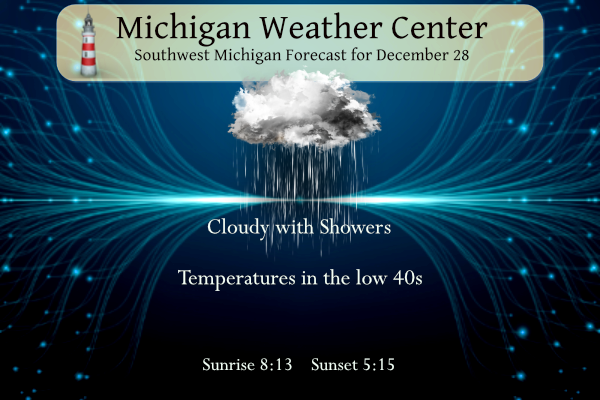
-- Clouds and Rain or Drizzle Through Friday --

A relative pressure minimum in the lower levels will consolidate
and deepen slightly over southern Michigan today, and maintain
patches of rain showers or drizzle amid widespread low cloud
cover. Despite the northeast flow, our area is still sourcing
relatively mild air, limiting the potential for freezing
temperatures. Kalamazoo and Battle Creek`s temperatures will spend
the calendar day at or above their record warmest lows for
December 28.

Latest consensus of short-term model guidance places the highest
likelihood of rain northwest of Grand Rapids this morning, then
south of Muskegon-Alma this afternoon. When it`s not outright
raining, drizzle will be possible on occasion as forecast
soundings still show times when clouds colder than -5 C will not
be present (which would likely keep the clouds ice-free).
Additional precip amounts through Friday will range from 0.1 to
0.3 inches for much of the area. Late on Friday, this upper-level
low will be kicked out of the region, and skies may clear Friday
afternoon around US-10.

.LONG TERM...(Friday night through Wednesday)
Issued at 323 AM EST Thu Dec 28 2023

-- Dry Start to the Weekend --

Rain showers move out on Friday evening as stubborn upper low/trough
is finally booted out by upstream kicker dropping southeast from
Canada. We`re still on track for a dry Saturday (and even a good
chance of sunshine) related to a brief period shortwave ridging in
between the two systems.

-- Some Light Snow for New Years Eve --

Precipitation chances ramp up again later Saturday night and
especially on Sunday with the arrival of the next upper trough/low
from the northwest. Guidance is in a little better agreement now on
the timing of the upper trough and the sfc reflection, with a weak
sfc low crossing the state on Sunday followed by northerly flow in
its wake on Sunday night. QPF solutions remain on the light side;
generally only a tenth of an inch or less.

While H8 temps support mostly light snow with this system, mild sfc
temps in the mid to upper 30s on Sunday suggest more of a light
rain/snow mixture with no travel impacts-- unless any heavier precip
rates manage to occur.

Snow showers ending late Sunday night with the passage of the sfc
and upper trough, although some lake effect may linger along the
coast into early Monday. A few slick spots could develop for the
overnight period of New Years Eve into early New Years Day as sfc
temps drop into the 20s.

Looks like more uneventful weather can be expected for Tuesday
through Thursday of next week with highs above freezing in continued
El Nino split flow pattern.
Got a little laugh from this
From NWS Atlanta on Twitter:
Wowza, look at that occlusion (purple)! What a heckin chonker!
#uswx
https://pbs.twimg.com/media/GCWvepMawAACtCt?format=png&name=900×900
Response from James Spann chief meteorologist in Birmingham, AL:
I’m not a hispter, so I had to look up the definition of “heckin chonker” after this post…
Another fact I find interesting is that the temp has not dropped below zero in nearly two years.
Woah! I forgot about that. So much for the polar vortex…
No wonder ticks and things have been so bad.
Ticks are sick and disgusting. Absolutely worthless! Hoping for a nice cold snap to o kill some of them off.
Yes let’s see about a 6 week period of cold and snow with tons of below freezing temps and a few nights around Zero! That would be awesome!
Tomorrow’s post will be on the history of weather satellites
In the debate between NWS Detroit and Grand Rapids yearly event summary. Looks like there were more storms on the east side of the state. I am not sure how the offices are funded. In looking at several other locations some have a lot of events while others have few. If something don’t happen you can not just make it up.
Slim
Huh? Make what up? There were events that happened that were not listed. Of course the NWS won’t “make stuff up”. This debate has just gotten ridiculous at this point. Bottom line the summary was lacking annd doesn’t get the scope of the year and could have been much better. At this point who cares what’s done is done.
You know it Kyle! Clearly GR had crazy weather and multiple wild weather events in 2023! You are spot on! Keep the facts coming and ignore 2 or 3 of the warm weather fanatics that post skewed and false information! It has been happening for years! Incredible!
Gaylord and Marquette’s offices offer little to nothing on 2023 weather events.
And that makes perfect sense because notable events were more limited there.
You’re right, Slim. It was a pretty quiet year for West Michigan. You can’t make up what didn’t happen.
Yep, Slim is spot on, very quiet weather year in 2023 for West Michigan.
Breaking news……. last winter (2022-23) GR had well above normal snowfall despite above normal temps! Who knew? Incredible over 110 inches of snow! Wow!
Yes, the winter of 2022/23 had a very snowy start and end (March) with 90.9″ in November, December and March.
Slim
3rd most snow in HISTORY! Now that is a crazy snowy winter! WOW, just wow, WOW!!!!!!!
In addition to the warm weather, the storm track has been missing us for much of November and December. Pretty typical of an El Niño. I’m certainly enjoying this weather while it lasts! Easy driving and cheap heating
Yesterday was +15 degrees above average. December is now +8.5 degrees above average. One of the warmest and least snowiest Decembers ever recorded.
My furnace is very happy. It barely comes on lately.
This will be the 2nd warmest December in most of Michigan and depending on any snow this weekend will be either a 2nd or 3rd least snowy at Grand Rapids. While January should colder that December there is a good chance that it too will be warmer than average.
Slim
Forecast for the next several days: rain! Horrible winter conditions yet again this weekend.
Breaking news – last year we had above normal temps and still had above normal snowfall! How is that possible? The warm weather nuts automatically assume no snowfall if above normal temps! The ignorance is off the charts!
2023 saw below average snowfall overall. I think you’re referring to 2022.
Last winter of the 110.7″ of total snowfall at Grand Rapids 90.9″ fell in November, December and March while just 19.2″ fell in January and February. So yes most of the snow that fell last winter was in the 2022 start of winter. Note that this year November and December are now at just 3.2″
Slim
Thanks for the facts slim!
The Latest teleconnectors still show a trend towards colder and snowier as we head into January! Get ready – it could be wild! Bring it!
Latest CPC shows continued above average temps into January! I love it!
Thanks MV for pointing out Detroit is more elaborate than GR! Point I was making yesterday. Grand Rapids summary was basic and omitted important events and details.
Of course. Detroit is a larger market and likely receives more funding. It’s like the Quad Cities v Chicago. Side by side, but night and day.
They need funding to type more in a summary? That’s interesting. Honest question because I don’t know how things work there. All I know is the summary was lacking.
The Detroit website seems to have more info and graphics than GR. Even their forecast summaries tend to be longer and more detailed than GR’s. More funding means more employees. More employees means more stuff that can be produced. The larger markets seem to have more stuff than the smaller markets. I don’t know this for certain but it seems that way, and it make sense.
SE Mich had more storms and tornadoes than West Michigan.
No one is denying SE Michigan had more. The issue ultimately was people denying that a lot happened in the GR NWS CWA and the summary lacked detail and the scope.
NWS Detroit also has more populated areas. Perhaps, GR simply doesn’t track events as closely that are 40-100 miles away from downtown in small towns. Just a guess.
The GR update was lame and not realistic!
Grand Rapids is still on track to have the 2nd least snowy month of December. At the current time there has been just 1.3” of total snow fall for December the record lowest of 1.0” fell in 2014. In 2nd place is 2.3” in 1912 and again in 1913. And for the season the total of just 3.2” is in play for the lowest so deep into the winter season depending on how much snow we get before January 1st we could set a new record for that as well the current record lowest is 3.6” if 1913. Unless we… Read more »
For sure more big time thunderstorm happen on the east side of the state.
Slim
The official H/L yesterday was 44/35 there was 0.04” of rain. There was no snow and now Grand Rapids is -16.4” below average in December and for the season GR is -21.9” below average this is a huge snowfall drought. There was 19% of possible sunshine. For today the average H/L is 33/22 the record high of 65 was set in 1984. The record low of -10 was set in 2017. The record snowfall of 5.4” fell in 1999. The most OTG of 19” was in 1951. Last year the H/L was 42/26 and there was 11” of snow OTG.
Slim
I remember the day of that record high of 65 it happened around 11PM for the record high on the 28th and carried over past midnight and the record high for the 29th is also 65. Before a warm front came thru there was 5” of snow on the ground that melted in a flash. A cold front came thru with big thunderstorms on the 29th dropping the temperatures down into the 30’s and on New Years eve there was a snowstorm that dropped a total of 7.6” of snow at Grand Rapids and a big time ice storm in… Read more »