First off our weekly weather history post:
January 7
1942: Record cold high temperatures occur as arctic high pressure prevails. The high temperature is only 4 degrees at Grand Rapids and 6 at Muskegon. At Lansing, the thermometer struggles to reach the zero mark during the day, with a frigid northwest wind making it feel even colder
1988: An arctic blast brings several days of sub zero cold to Lower Michigan, including record lows this morning of 15 below zero at Grand Rapids and 11 below at Muskegon.
January 8
1880: Temperatures remain above freezing for the fifth consecutive day during the warmest January on record at Lansing.
1965: Temperatures soar to record highs of 59 degrees at Grand Rapids and Lansing and 55 degrees at Muskegon. A cold front moves through and temperatures will only reach the 20s the next day.
January 9
1930: A snowstorm drops from 4 to 8 inches of snow across southwest Lower Michigan.
1977: Record cold prevails during one of the most severe winters in Michigan history. Records include the 17 below zero at Lansing, 14 below at Grand Rapids and 8 below at Muskegon.
2015: Temperatures in the single numbers and lake effect snow showers create icy roads resulting in a 193 car pileup on Interstate 94 and both east and westbound lanes are shut down between Battle Creek and Galesburg.
January 10
1982: Extreme arctic outbreak brings record cold temperatures and massive lake effect snow totals. Muskegon has their snowiest calendar day on record with 22 inches. This contributes to the all-time record monthly snowfall of 102.4 inches (8 and a half feet!) at Muskegon for January 1982.
January 11
1890: Temperatures reach a record high of 63 degrees at Lansing during one of the warmest January’s on record.
1979: Arctic air and a deep snow cover combine to drop the temperature to a record low of 21 below zero at Grand Rapids.
January 12
1912: Muskegon sets their all-time record low for the month of January at 21 degrees below zero during their coldest month on record.
1918: Record cold is experienced at Lansing with 18 degrees below zero and Grand Rapids at 14 below during one of the coldest winters on record.
2005: On January 12, 2005, dense fog blanketed lower Michigan. Numerous highway accidents near Lansing killed two people and damaged almost 200 vehicles. At least 37 people were injured. One pileup involved 50 vehicles and necessitated the closure of 12 miles of Interstate 96 between Okemos and Webberville.
January 13
1952: Dense fog with visibility near zero leads to a number of auto accidents across southwest Lower Michigan. The fog persists for three days from the 12th to the 14th.
1979: A massive storm dumps heavy snow across southern Lower Michigan. Temperatures in the teens and strong winds lead to heavy drifting of the powdery snow, causing travel to come to a halt. The snow, at times falling at more than an inch an hour, caused power outages due to broken tree limbs. Snow accumulations were up to 3 feet, causing some roofs to collapse. South Haven had 21 inches of new snow added to 24 inches already on the ground. Grand Rapids saw 13.5 inches of snow and 2 to 4 foot drifts with wind gusts between 25 and 35 miles an hour.
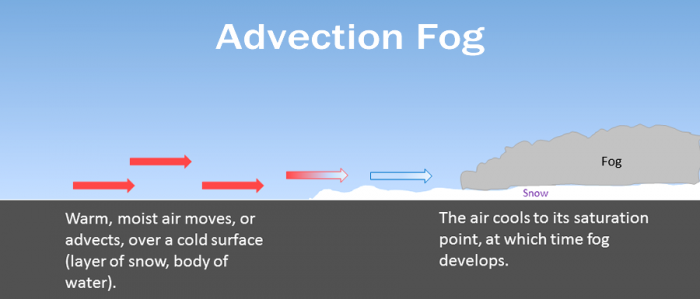
With the snow melting we will have advection fog. Advection fog occurs when moist air passes over a cool surface by advection (wind) and is cooled. It is common as a warm front passes over an area with significant snow-pack.
Some light freezing drizzle or patchy freezing rain is possible this morning. The freezing precipitation as well as a refreeze of meltwater from snow melt may result in some slippery spots on area roadways. Temperatures will rise above freezing through the course of the morning. Areas of fog may become dense this afternoon and tonight with visibility dipping to near zero at times.
Rain will transition over to snow Thursday night which will continue into Friday morning. A brief wintry mix of precipitation is possible Thursday night during the switch from rain to snow. Light accumulations of snow are possible by midday Friday on the order of 1 to 3 inches. Arctic air and lake effect snow showers are expected over the weekend and into early next week.
Confidence has become much stronger that we will miss out on much of, if not the entire snowstorm that will be ongoing Fri night into Saturday. Good model consensus now exists in taking the heavier swath of snow now through Ohio. This is the result of the developing upper low digging a little further south, and the sfc front/upper jet being a tad farther east when the wave lifts NE. This will result in our area being cold once again, with some lake effect closer to the lakeshore with an almost due N low level flow.
The cold air and lake effect near the shore will remain through the weekend. The threat of snow will increase by Mon a bit. A fairly strong upper low will dive SE over the area. This will deepen the moisture and help to boost lake effect a bit ahead of it. Once the wave passes, colder air will be reinforced with the low level NW flow behind it bringing in -20C air at H850. Lake effect will become re-established for the western half of the area.
Models are still consistent with the warm air returning around the 19th pushing temperatures back above freezing into the 40s as another zonal pattern pushes the cold air back into Canada.
Today: A 40 percent chance of showers. Areas of fog. Otherwise, cloudy, with a high near 44. South wind 11 to 14 mph.
Tonight: A 50 percent chance of showers. Areas of fog. Otherwise, cloudy, with a temperature rising to around 50 by 5am. South wind 16 to 18 mph.
Thursday: Showers. Areas of fog. High near 51. South wind 15 to 18 mph. Chance of precipitation is 90%. New precipitation amounts between a tenth and quarter of an inch possible.
Thursday Night: Rain, possibly mixed with snow showers before 3am, then snow showers likely, possibly mixed with freezing rain. Low around 26. South southwest wind 10 to 15 mph becoming north northwest after midnight. Winds could gust as high as 23 mph. Chance of precipitation is 80%. New snow accumulation of less than one inch possible.
Friday: Snow showers likely, possibly mixed with freezing rain before 7am, then a chance of snow showers between 7am and 1pm. Mostly cloudy, with a high near 27. North northeast wind around 15 mph, with gusts as high as 24 mph. Chance of precipitation is 60%. New snow accumulation of less than a half inch possible.
Friday Night: A 20 percent chance of snow showers after 1am. Mostly cloudy, with a low around 12.
Saturday: A 20 percent chance of snow showers before 1pm. Mostly cloudy, with a high near 19.
Saturday Night: Mostly cloudy, with a low around 8.
Sunday: A slight chance of snow showers. Mostly cloudy, with a high near 19.
Sunday Night: A chance of snow showers after 1am. Mostly cloudy, with a low around 9.
M.L.King Day: Snow showers likely. Cloudy, with a high near 19.
Monday Night: A chance of snow showers. Mostly cloudy, with a low around 11.
Tuesday: A chance of snow showers. Mostly cloudy, with a high near 19.
Cue—> Big Tent Revival – Faith Of A Little Seed – YouTube
https://www.youtube.com/watch?v=6OOgoPSnm84
Mark Gets HIS GREEN….Give MY GREEN Back….stay CUED…
Let it……MELT …..LET IT….MELT……Let it MELT….
(to the TUNE of Let it Snow)
#HURRYSPRING2018
What Happen to MMJ Symbol?
They dropped us front the dense fog advisory, which is a headscratcher. You should see the fog here.
.UPDATE…
Issued at 937 PM EST Wed Jan 10 2018
I made two changes to our ongoing forecast. I have expunged the
eastern 2/3rd of our fog advisory on a diagonal from near
Kalamazoo to Evart. I also increased our forecast high to the mid
to upper 50s based on how our current temperature has already
reached the upper 40s at GRR and that matches the ECE mos with
gives GRR a high of 59 Thursday.
RIGHT NOW…@ Thee YOCS…Misty Foggy & Drizzle.
LOVELY…
Super foggy here.
Same here.
Looks like we are going to bounce back and forth with rainy warm-ups and cold snaps producing snow along the lake shore. The rest of us get the big goose egg.
Sounds about right BJ.
Climatology for today January 10th At Grand Rapids, MI
The average High/Low is 31/18
The record high is 57 in 1975 the coldest maximum is 5 in 1982
The record low is -19° in 1942 the warmest minimum is 38 in 2000
The largest snow fall is 5.2” in 1999
The most on the ground is 17” in 1999
Last year the H/L was 47/27° there was 1.3” of snow fall (Before day break) and the day started with 4” on the ground (see next post)
Slim
On this date last year the day started with 4” of snow on the ground and the high here in Grand Rapids reached 47° this was the start of a pattern change that would last the rest of January and into February. The temperatures reached 61° in January and all the way up to 66° in February. As of this date last winter the seasonal snow fall at Grand Rapids had reached 45.7” . But for the period from January 10th to the end of February only 9.4” of snow fell. Note this season the total snow fall now stand… Read more »
Yet another amazing similarity to last years Winter. The only trade off would be colder this year but less snow. Crazy stuff!
Less snow than last winter. Who would have thought? And very similar temperature timing patterns.
I am watching the potential weekend snow storm for a different reason the Indy is. We are heading down south on Tuesday getting ready for our cruise. As we are leaving out of port Canaveral my plans are to take an eastern route so will be watching to see how much snow Ohio gets the good news is that if the storm hits Friday night into Saturday there will be a lot of time for cleanup. In January of 2016 when we went down there was a major snow storm in Kentucky and Tennessee. While the Bowling Green area of… Read more »
1-3 inches of snow Friday 2-4 on Saturday 3-6 on Sunday temps in the teens winter keeps kicking hard .. INDYDOG14!!
?????
Where are you getting those number from???
Slim
Lk Michigan ..winter weather advisorys coming Friday! INDYDOG14!
It would probably be better to just admit all the countless posts you and Rocky have been making all week on this blog about guaranteeing a huge snow storm for GR this weekend were wrong.
Last I new this was a weather blog Well u guess my summer vacation just started early see u all next winter!! Sorry I post about winter!! And yes it’s going to snow this weekend mark it down! Happy new year INDYDOG14!!
Both the GFS and Euro show GR getting only 1″ or less of snow for the entire weekend. Euro also has GR getting up to 49 degrees today and 56 degrees tomorrow!
The EURO model is garbage this winter! We may need to start relying on the JEM and RDB model!
Prolly can’t do any worse. 😁
Confidence has become much stronger that we will miss out on much of, if not the entire snowstorm that will be ongoing Fri night into Saturday. NWS Grand Rapids
I can’t believe it’s been 13 years since the big pile up in I-96. That was horrible.
I’m watching this storm going to bomb out over Ohio winds pick up around the storm brings heavy lk effect snows we get dumped on in west Michigan!! Maybe a blizzard!! It’s going to get cold temps in the teens Sunday this one berrrs Watching. Have a good hump day INDYDOG14!!
Except the wind looks to be mostly out of the North so the snow will be confined to over the lake and the immediate lakeshore or beach.