We have a cool 48° this morning at 7 am with another beautiful late summer day in store.
[columns] [span6]
S.W. Lower
[/span6][span6]
S.E. Lower
[/span6][/columns]
[columns] [span6]
Northern
[/span6][span6]
U.P.
[/span6][/columns]
Weather History
August 16
1938: A tornado struck between Oil City and Mount Pleasant in Isabella County. No one was injured but a home was torn apart with the roof carried about 100 yards.
1979: High pressure from Canada brings record cold temperatures with Muskegon falling to 36 degrees, the coldest ever recorded there in August. At Grand Rapids it falls to 40 degrees and at Lansing 39.
August 17
1988: It is the last hot day of the hot and dry summer of 1988. Record highs were set at Grand Rapids with 98 degrees, Lansing with 95, and Muskegon with 93. Thirteen of the first seventeen days of August had highs over 90 degrees at Grand Rapids, but none after today. The transition to cooler weather is marked by severe thunderstorms that bring large hail and damaging winds during the late afternoon and evening.
August 18
1943: Autumn is in the air with record cool temperatures of 41 degrees at Grand Rapids and 43 degrees at Muskegon.
1955: West Michigan is in the midst of another heat wave with Grand Rapids setting a record high of 97 degrees, helping this become the second hottest August on record there.
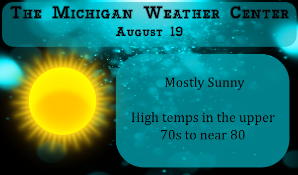
August 19
1939: A total of 4.22 inches of rain falls for the wettest August day on record at Grand Rapids.
1977: Cool air from Canada brings record lows of 37 degrees at Lansing and 43 degrees at Grand Rapids.
1996: Severe thunderstorms produce damaging winds from Cadillac to Ionia. Montcalm County is one of the hardest hit places. Numerous trees are blown down from Greenville to Sheridan. In the town of Sheridan, there several reports of building damage mostly to roofs. A school in Greenville had a large plate glass window blown out.
August 20
1992: Temperatures fall into the 30s in some rural areas during the coldest August on record at Grand Rapids. Record lows for the day include 42 degrees at Muskegon and 43 degrees at Grand Rapids.
2007: Heavy rain falls across southern Lower Michigan for the second consecutive day. Grand Rapids and Lansing both set daily rainfall records and some places see over 4 inches of rain for the two day total on the 19th and 20th.
2016: Tornadoes strike from Bangor to Grand Rapids and east of Belding. There were no injuries, despite damage to several buildings and hundreds of trees being downed.
August 21
1958: Heavy rains fall for the second day in a row, causing some flooding in the Grand Rapids area where the two day rain total from August 20-21 was over 4 inches.
1975: A tornado blew down fruit trees in an orchard at Climax, in Kalamazoo County.
2003: A tornado with top winds around 120 mph strikes eastern Ingham County injuring two people and destroying two homes. The damage path was 4 and a half miles long and up to one half mile wide.
August 22
1936: The Dust Bowl summer of 1936 produced more record heat, with a high of 98 degrees at Grand Rapids and 94 at Lansing.
1964: Tornadoes struck in Calhoun, Lenawee and Hillsdale Counties. Three people were injured northeast of Battle Creek as a house and factory were damaged.
1966: A tornado struck Bellevue in Eaton County, damaging a house, garage and two cars.
2001: Severe weather and flooding hit Allegan, Ottawa and Kent Counties. Damaging winds hit Hudsonville, Plainwell, Dorr and Grand Rapids. Flooding occurred in eastern Van Buren and Kalamazoo Counties where three to five inches of rain is estimated to have fallen in less than 6 hours. Several streets were closed by flooding in Oshtemo flooded. Some businesses had to pump water out of their stores in Kalamazoo during the height of the storms.
Forecast Discussion – North
High Impact Weather Potential: A few thunderstorms possible Thursday
and Friday, mainly north of M-72.

Pattern Synopsis:

Longwave troughing over the far NE CONUS will continue to slide off
into the Atlantic while anomalously strong ridging grips the western
half of the country. NW flow over the Great Lakes will persist into
the weekend while a trough moves onshore in the Pacific NW. A weak
shortwave embedded in the large scale flow is expected to propagate
across south-central Canada late Thursday into Friday, inducing a
cyclone at the surface that will trek eastward into Quebec by
Saturday. Meanwhile, surface high pressure will encompass much of
the CONUS east of the Mississippi River through the period.

Forecast/Details:

Broad anticyclonic low-level flow will help bring a ribbon of
favorable moisture from the Great Plains into the northern Great
Lakes by Thursday. Surface dewpoints in the low/mid 60s are expected
across eastern upper and Tip of the Mitt Thursday and Friday. Subtle
forcing mechanisms, both near-surface and aloft, could help spark
showers and a few thunderstorms both days. MLCAPE of 1,000-1,500
J/kg across eastern upper with lesser amounts across far northern
lower would help support surface based convection given initiation.
Weak shear far below supercell thresholds should exist aloft. While
hodographs are not incredibly impressive, some stronger flow near
850mb could provide some favorable low-level streamwise vorticity
(~150 m2/s2 0-3km SRH) worthy enough to keep an eye on. Friday
presents a very similar scenario as Thursday, but with slightly
stronger instability and shear across the aforementioned areas:
enough instability and low-level shear for some thunderstorms, but
no severe is expected at the moment. Counties south of M-72 are
expected to stay mostly dry heading into the weekend. Otherwise,
temperatures look to warm up to end the week. Afternoon highs
could reach above 80, and potentially above 85 for some on Friday.

.LONG TERM...(Friday night through Tuesday)
Issued at 235 AM EDT Wed Aug 19 2020

High Impact Weather Potential: Monitoring rain/thunder potential,
especially next week.

Weak NW upper-level flow is expected to persist into early next week
as a seasonably strong trough is anticipated to trek from the
Pacific NW towards the Great Lakes across southern Canada. Guidance
differs greatly with the handling of systems over the weekend.
Current confidence resides in subtle forcing aloft coinciding with
favorable low-level moisture to bring at least some rain chances and
maybe rumbles of thunder Saturday and Sunday across the area.
Confidence in timing, potential, and propensity of any rain/storms
will increase over the coming days.

Surface dewpoints of 60+ degrees could linger into next week, which
would help bring potential for multiple rounds of showers and
thunder during the back half of the period. A cyclone may develop in
southern Canada with favorable ascent aloft and move across the
Hudson/James Bay area early next week, potentially bringing a front
through the area which could spark precipitation. At this time, more
favorable shear for stronger storm development appears it will be
displaced far to the north during early next week. However, guidance
hints at a stronger system supported by an embedded shortwave moving
through the region during the middle of next week. Considerable
uncertainty exists at this time range, but will continue to monitor
this potential moving forward. Otherwise, above average temps near
80 - and potentially higher - look to last into next week. Current
confidence hedges with the warmer side of guidance which places the
jet further north this weekend heading through next week.
Forecast Discussion – South
The upper trough currently over the GrtLks region lifts out by
Thursday and the northwest flow aloft is replaced by a weak zonal
flow. Actually the upper pattern is evolving into a split flow
regime, with the main belt of stronger westerlies remaining off to
our north and the srn stream remaining to our south. In addition
a rather dry air mass remains in place through the weekend. All of
this implies a prolonged dry pattern.

Rising heights and quickly recovering H8 temps leads to a warming
trend with highs well in the 80s again by the end of the week and
into the weekend. Humidity not much of factor going forward with
dew points remaining in the 50s through the rest of the week and
only around 60 for the weekend.

Can`t rule out a stray shower or storm impacting the U.S. 10
corridor Thursday into Friday. A sfc boundary sets up across upr
MI and the some of the convection associated with this feature
could slip south toward Ludington and Clare. Deep layer thickness
progs support this idea, although the dry air mass overhead should
to lead to a diminishing trend of any convection attempting a
southward dive into our area later this week.

The GFS tries to send a cold front through the area on Sunday
with scattered showers and storms, but the ECMWF does not support
this idea and keep us dry. Considering the split flow pattern
aloft, believe dry is probably the more likely outcome as this
approaching cold front just dissolves. Next week looks to feature
well above normal temperatures and a continuation of mainly dry
weather, at least the first half of the week.
WOOD has the heat cranking in again starting this weekend. Here comes more 90’s and humidity. 👎
https://www.woodtv.com/weather/forecast/storm-team-8-forecast/
August is now up to 75% total sunshine and climbing. I love it!
Definitely a lot better working weather with the lower dew points compared to last weeks 90 degrees and smothering humidity. The past several months have not been good at all for getting anything done outside or just plain working. AC is still on because now the golden rod has bloomed and 3 of us have severe allergies this time of year. Open windows are not an option at night.
I would love to open windows too, but to dry and all the stuff floating around.
Low of 54* degrees out at thee YARDofBRICKS NE of GR nice cool start as we get towards the end of August now look for more of this beautiful Fall feeling and now the NWS says the end of August looks below average around here no more heat that’s fine with me hasn’t been that bad anyways ….Have a nice day INDY
Both the official low at GRR and here at my house overnight was 51 that is the coolest low since June 15th when the low was 47. So far this August is near average with a mean of 71.0 that is a departure of -0.6. At the current time it is sunny with a temperature of 73 here with a DP of just 52. With the clear skies and low DP that will lead to cool overnight lows.
Slim
Other then the beginning of Julys mini wave this summer has been not to bad heat wise some said August would be hot into September boy they where off there rockers but then again haven’t saw much of them around here lately ….Looks below normal going into September from the NWS …INDY
Just returned from my morning walk. Beautiful morning. With the avg high/low now 80/60, I love this time of year. The low humidity is a nice bonus too.