[columns] [span6]
[/span6][span6]
[/span6][/columns]
[columns] [span6]
[/span6][span6]
[/span6][/columns]
As you can see above the active weather continues to be in northern Michigan and the U.P. while the rest of us continue with our warm and dry pattern. The CPC has been showing an increasing chance of rain late August into the first week of September for the state with temps in the 70s.
We have had four days with measurable rain in Otsego totaling 1.93 inches for the month bringing our total to 8.32 inches which fell mainly in June and early July.
Forecast Discussion Southern Michigan
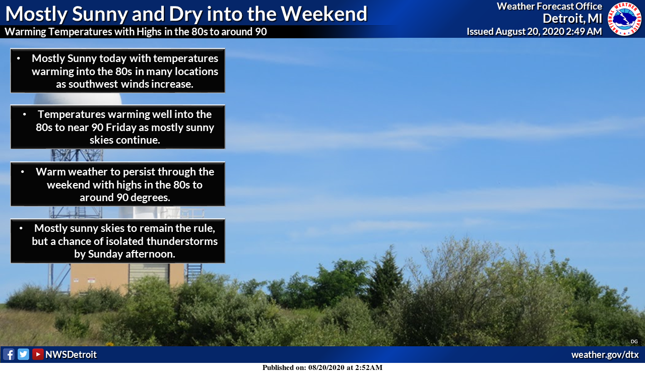
-- Well above normal temperatures and predominately dry --

Through the upcoming weekend southwest Michigan will remain
sandwiched between an active frontal zone to our north and a srn
stream trough lifting northeast from the Gulf Coast. The air mass
inbetween these two features remains relatively dry for August,
with PWATs only around one inch and surface ridging prevailing.

Temps at 850 mb rise to around 18C after today, supporting highs
well into the 80s and perhaps near 90. Sfc dew points in the 50s
come up only slightly through the weekend, so humidity levels
look to stay in check.

The frontal zone does try to come father south and east on
Sunday, but it`s dissipating as it does so then rebounds back
north as a warm front again early next week. H8 temps next week
are shown to be around 20C, so a continuation of the very warm
temps expected.

-- Clouds and showers occasionally flirt with U.S. 10 area --

Mid level clouds and perhaps even a few light showers/sprinkles
will impact the area from Ludington to Clare this morning. This
area also stands a small chance of seeing a shower or storm
through the weekend due to it`s closer proximity to the sfc front
over Upr MI. Thickness lines are oriented NNW to SSE which
supports the possibility of some of the convection over Upr MI and
Nrn Lwr MI carrying southward down toward the U.S. 10 corridor at
times. This is reflected in the SPC tstm outlooks which do
include this area in the general thunder.
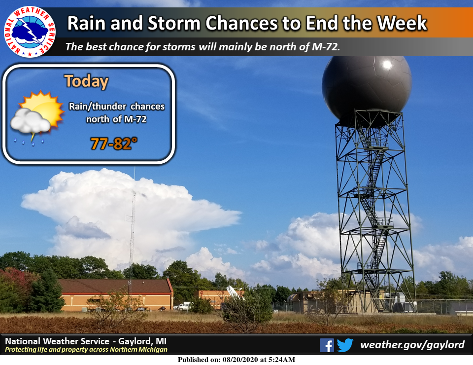
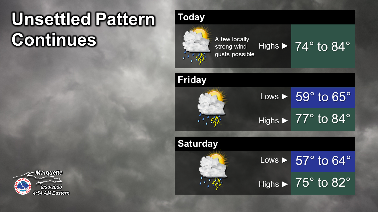
Forecast Discussion U.P.
.SHORT TERM...(Today and tonight)
Issued at 406 AM EDT THU AUG 20 2020

With a warm front remaining in place across Lake Superior and the
eastern UP this morning, showers and a few thunderstorms persist
over these areas. Elsewhere it is cloudy, warm, and humid. Lows this
morning are not expected to be much lower than where temps are now
(3 am) with mid 60s expected to be as cool as anyone gets. A
departing 25-35 kt LLJ is keeping things windy on the bay and Lake
Michigan. This LLJ will pull out today leading to a gradual
weakening of the winds, but not before the stiff onshore flow builds
waves high enough to cause a high swim risk for the Schoolcraft
County beaches in Manistique and east to Seul Choix Point.
Therefore, have issued a Beach Hazards Statement through early
afternoon.

Some partial clearing is expected in our Wisconsin-bordering
counties this morning which, beneath 850 mb temps of around 16-17 C
on the warm side of the front, will allow temps to climb into the
80s. Closer to Lake Superior, however, weakening background flow
will allow a lakebreeze to develop off of Lake Superior in
combination with the surface reflection of the aforementioned front.
Convergence along this boundary in a humid and unstable atmosphere
(MLCAPE increasing to 1500-2000 J/kg this afternoon) will allow
thunderstorms to develop across the central UP this afternoon and
then sink southward into the south-central. Although there is some
turning in the wind from WSW at the surface to W at 850 mb and NW at
500 mb, speeds are weak and thus effective shear values are progged
to be around 20 kts or less. Therefore, can see why SPC keeps us in
just the general thunder category. However, will note that this type
of setup with a synoptically-enhanced lakebreeze and decent CAPE has
led to pulse storms with locally damaging wind gusts in the past
when elevated cores collapse. So would not be surprised if some more
of that occurred this afternoon/evening. Most of the CAMs have a
signal for stronger thunderstorms, except for the experimental ESRL-
HRRR which is suspiciously dry.

Tonight, winds are expected to go light as weak high pressure
develops northeast of Lake Superior. With high dew points persisting
tonight and rainfall today, most models develop widespread fog
tonight. Fog often keeps temps warmer than guidance indicates, so
hedged warm with lows tonight towards a blend of the 75ht percentile
of all guidance and the CONSRaw. This combo gives lows in the low to
mid 60s across the board.

.LONG TERM...(Friday through Wednesday)
Issued at 418 AM EDT THU AUG 20 2020

The long-term period will start with the unsettled period already
well underway, as evidenced currently. Just when it seems like the
models have honed in on some commonalities, a few go a bit astray.
However, high confidence exists on precip occurring Friday into
Saturday, it`s just a matter of refining those finer details once
the time period inches closer.

Amplifying shortwave late this week approaching the Upper Great
Lakes, traversing along the U.S./Manitoba -> Ontario border will
usher in showers and storms in the western U.P. on Friday, with
some discrepancies on how well they hold together as they track
eastward. Another round of convection is anticipated ahead of the
trough axis Friday night into early Saturday, with yet another
round anticipated later Saturday with the trough passage. Could
strong storms be possible associated with this trough axis? Not
out of the question, but just a bit too much uncertainty currently
given the aforementioned discrepancies. Specifically, there is a
signal present for a potential convective complex to develop and
track near the WI/MI border overnight Friday. Additionally,
locally moderate rain could be possible with ample atmospheric
moisture advecting in. Bottom line: stay tuned.

A bit of a break from rain chances appears overnight Saturday into
Sunday (assuming the aforementioned trough axis doesn`t slow down
too much). The ECMWF keyed in on additional shower chances later
Sunday (looks to potentially be diurnally-driven), but other
models remain dry, so opted for low-end slights.

Early next week, low pressure system crossing northern Ontario
looks to drag a cool frontal boundary along with it, triggering
yet another round of potential showers and thunderstorms. As for
temperatures, the GFS continues to back off on the previously
advertised cool temps moving in late this weekend/early next week,
but really tries to pull unseasonably cool air close to Upper
Michigan toward the end of this forecast period. Essentially,
expect seasonable temps to prevail in the long-term period, with
warm temps dominating early on, and a return closer to normal for
the latter half of the period.
Currently 79* degrees out at thee YARDofBRICKS NE of GR chalk up another beautiful August day we have had plenty with no heat involved and with Summer more then a 3rd over let’s keep them going into September baby ….Yes …INDY
Here is the number of official days of 90 or better across the area so far this summer Grand Rapids 14. Muskegon 15. Kalamazoo 16. Holland 10 and Lansing 13. While all locations have seen one or more days of 90 or better than average Muskegon so far is the most above average. The 30 year average at Muskegon is only 3 days of 90 or better but this year they and now at 15. While Kalamazoo has seen 16 days their average is 13. And at Grand Rapids the 30 year average is 10 and there have been 14… Read more »
Above average temps, above average 90+ days, above average sunshine. I love it!
Today it the 3rd Thursday of the month and that means the updated CPC long range guess is now out. Their guess as of today is for a warm fall in our area with near average precipitation. Then for the upcoming winter season their guess is for a equal chance in the temperatures and above average in the precipitation. So we shall see how that plays out.
Slim
Last official 90* degree day Was July 24th in Grand Rapids Michigan I believe yes almost a month ago sorry 89* doesn’t count ….let’s be real on here thank you!! INDY
A month since our last 90? It was 90 here last weekend as well as most reporting locations around the area. I think some have to work on their math skills. I don’t really like Bills headline for his post, “Heat wave on the horizon”. Must be Fall is here?
Poor Bill has been talking snow on his blog the past few months during all this heat. He truly lives in the wrong area. I feel bad for him with our short winters.
While Grand Rapids only received 53.5” of snow fall last winter for most locations on the 43rd parallel that would be a snowy winter. And as for a short winter well last winter the first 32° low was on October 18 and the last was on May 13th that is 214 days I would not call that short. I know many of the 214 days were warm but that is one way to look at the length of the cold season.
Slim
32 degrees is not “winter” in my opinion. We could hit 55 or 60 and then get down to 32 at night. That’s not winter.
If you want to play with numbers, I think 11 out of the last 12 months in GR had temps at least in the 50’s and 60’s.
Thanks for the weather stats and the realness Slim it thats even a real word lol but we all know what I mean time after time ….INDY
Old Farmer’s Almanac is out today: “a light winter for most of us here in the United States with warmer-than-normal temperatures in the forecast for a large part of the county.” Specifically for the Great Lakes it sounds like a repeat of the last few winters: “more wet than white.” I love it!
Get ready. Another heat wave is on its way. It looks as if August may be another above average temp month.
Lol … welcome back to the blog yes it’s been almost a month now since our last 90 we are probably due for another one soon nothing new its August ?? right but we will see …. Currently we had a nother nice evening no fans attached keep them coming as we go into the end of August …Have a super Thursday …INDY
We’ve already hit 89 degrees three times in August! Going for more even though some on here have said summer was on the way out. I love it!
Mid to high 80’s is a heat wave ?? If that’s the case INDY better go on vacation from here lol…
INDY
When both Bill and others are calling it a heat wave, yes, it’s a heat wave. But nice try to spin.
Who poor Bill or Bill Steffens GR chief meteorologist lol… Mookkiee go back on vacation thank you ….INDY
https://www.woodtv.com/bills-blog-2/weather-pattern-continues-mostly-sunny-and-dry-heat-wave-on-the-horizon/