
Hard frost this morning – 26° down here at the station – 30° both in Kalamazoo and Grand Rapids (7:30 readings). We are in one of the low lying areas down by the Kalamazoo river. Most areas in southern Michigan are in the mid to upper 20s to 30°.
It is inevitable, I put the snowfall forecast on the Michigan Forecast page in the NWS Graphics and Futurecast tabs, this will also show up on the Point forecasts. Western U.P. will pick up their first accumulating snows – The upcoming weekend storm is quite complicated for Upper Michigan. Overall, it is likely most locations will see snow falling sometime between Thursday night and Sunday, but the best chance for accumulating snow will be across the western U.P. and across higher terrain locations. It is challenging to predict potential snowfall totals for this weekend storm, but as of now generally 3-5” is expected across the higher terrain.
For lower Michigan we could see snowflakes mixing with rain especially on Halloween, not seeing any accumulations though.
Another feature on the Michigan Forecast Page is the updated Interactive Radar – Google maps updated their terrain feature over the past year or so – you can zoom right down to your house with the High Resolution radar. I also added the Great Lakes water temperatures to the Atmospheric Conditions page.
Today is weather history day which includes the October 24 2001 storm which blew through northern Illinois, Ohio and southern Michigan (I remember that one well)….
October 22
1953: An extended October warm spell culminates with record highs around 80 degrees. At Grand Rapids, it is the third consecutive day with record high temperatures.
October 23
1955: A cold front moving into warm and humid air results in severe thunderstorms across southwest Lower Michigan. High winds and hail caused considerable damage to windows, roofs, automobiles and trees as a severe storm passed about 15 miles south of Grand Rapids.
1959: A tornado struck near Evart in Osceola County around 4 PM, with only minor tree damage.
1963: Michigan is in the midst of a spell of record warm weather. Lansing reaches 80 degrees or higher on five consecutive days from the 22nd to the 26th.
October 24
1967: A tornado injures four people as it destroys a trailer in Monterey Township, Allegan County.
2001: A squall line moves across southern Lower Michigan producing widespread wind damage and several tornadoes. The town of Schoolcraft in Kalamazoo County is hit by winds estimated up to 100 mph, causing extensive tree damage and some structural damage. The town of Marshall in Calhoun County also sustains some damage to homes as winds gust between 60 and 80 mph.
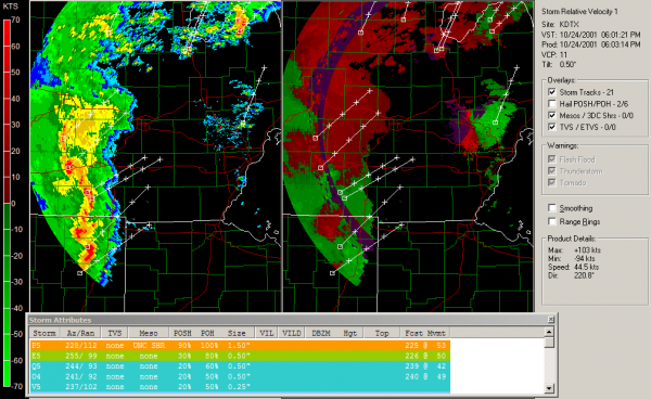 At 3:46, a tornado warning was issued for St. Joseph County, Indiana and southeastern Berrien County, Michigan and Cass County. A few minutes later, another tornado, perhaps the strongest of the outbreak—an F3—touched down and did major damage to buildings in Crumstown, a town near South Bend. The line moved into South Bend at exactly 4:05 P.M., producing 89 mph (140 km/h) winds at the airport. The tornado that hit Crumstown later hit Niles in Berrien County, then moved east-northeast into Cass County and dissipated in northwestern Saint Joseph County, Michigan. Two people were injured by the Crumstown tornado, and one man later died of his injuries.
The feature image is what was left of Curtis Trailers in Schoolcraft – The Schoolcraft High football field, which was supposed to host a district playoff game that weekend, was wrecked. The press box was a crumbled mess on the field. A row of tall, thick evergreen trees that lined the fence and roadway snapped in two like toothpicks.
The storms prompted tornado warnings in Kalamazoo and Calhoun counties, and skies reportedly turned very green as the storms approached. The storms caused major damage to the Schoolcraft area of Kalamazoo County, where straight line winds in excess of 120 miles per hour reported, causing a golf dome to blow away, ripping the roof off a house, ripping the front wall of a brick house off and twisting irrigation sprinkler systems. Strong winds were also reported in the City of Kalamazoo. In Calhoun County, strong straight line winds also struck near Tekonsha, causing damage.
Later in the evening the severe storm produced straight line winds through the campus of Michigan State University downing many trees and damaging buildings. The National Weather Service estimates most of the downbursts through East Lansing were between 60-80 mph, with one reaching 120 mph (190 km/h). The supercell that passed through East Lansing also spawned 2 tornadoes in the Saginaw area. By 5:30 p.m., the severe weather moved out of Indiana and into Ohio where damage was not as severe. One tornado was reported in Ohio, an F3 that moved from Paulding County into Putnam County. That tornado caused major structural damage to buildings near Fort Jennings, Ohio. The severity of the activity began to wane later that evening. By 7:30, all severe weather watches were discontinued.
October 25
1962: Snow accumulates an inch or two across southwest Lower Michigan as an October cold snap continues. Low temperatures fall into the 20s at most locations for four straight days from the 24th to the 27th.
October 26
1869: Several inches of snow pile up across southwest Lower Michigan. The 5.5 inches at Lansing is a record for early season snowfall and the high temperature there only reaches 34 degrees.
2008: Thunderstorms combine with a cool air mass to bring some hail to Lower Michigan. Small hail covered the ground in a few locations.
October 27
1967: The heaviest October snowstorm on record strikes southwest Lower Michigan with widespread amounts greater than 6 inches. A total of 8.4 inches at Grand Rapids is almost double the amount of the next greatest October snowstorm.
October 28
1869: Michigan is in the grip of an icy cold wave. The temperature falls into the teens for eight consecutive days at Lansing, where it is the coldest October on record.
My low here was 27.5. A good hard frost. Hopefully the allergy season is winding down!
I had a low of 29° here at my house. First frost of this fall season
Slim