May 17
1962: An early season heat wave sends temperatures into the upper 80s and lower 90s across Lower Michigan. Record highs on this date include the 91 at Grand Rapids, 89 at Lansing and 88 at Muskegon.
May 18
1915: Lansing records their latest measurable snow on record with 0.4 inches, and Grand Rapids does also, with 0.2 inches there.
May 19
1923: A tornado injured two people in Kent County as it moved through rural areas from east of Coopersville to near Sparta.
2002: Snowflakes fly across Lower Michigan as record cold weather prevails. Record lows include the 26 degrees at Lansing, 29 at Muskegon and 30 at Grand Rapids. The freezing temperatures cause heavy losses to orchards across western Lower Michigan.
May 20
1975: A tornado injured one person as it destroyed two mobile homes at Byron Center in Kent County.
1977: The last half of May is unusually warm. Record high temperatures in the upper 80s and lower 90s are set across Lower Michigan from the 16th to the 28th. This helps make it the warmest May on record at Grand Rapids.
May 21
2001: A swarm of at least 20 tornadoes descend on Lower Michigan. Fortunately, most of the tornadoes are relatively weak and only five people were injured. Damage included dozens of trees downed, barns blown over and roof and siding damage to several homes. Three homes and a golf course were heavily damaged north of Hartland in Livingston County.
2004: Severe weather causes widespread damage across southern Lower Michigan. Thunderstorm winds up to 70 mph, large hail and flash flooding occurred as a squall line moved from Benton Harbor to Ann Arbor. Hundreds of trees are knocked down and thousands lose power.
May 22
1917: Cold rain mixes with snow and temperatures rise only to the lower 40s after morning lows in the lower 30s.
1963: Snowflakes fall at Lansing as morning low temperatures in the 30s only rise to the mid and upper 40s.
May 23
1966: A barn was destroyed by a tornado near Gobles in Van Buren County.
1973: A tornado destroyed three barns and damaged an industrial building in Winn in Isabella County.
We have a chance to dry out today after a wet beginning to the week. Temps will begin to warm up and a taste of summer will permeate the air as we close out the week. Of course, this also means lawn mowers will be out in force to start mowing down the hay field we call our lawns.
[columns] [span6]
[/span6][span6]
[/span6][/columns]


Enjoy the warm air…the 40s will be very hard to take a week from now
Sunny and a very nice 69 here at my house. Great day to open up the windows and enjoy this great day. We deserve it
Slim
Yes slim it’s perfect outside it could stay like this to September that would be fine with me …INDY
Has anyone else noticed how some of the trees are late this year in getting all of their leaves on them. And looking at the web cams from the UP.
https://www.mtu.edu/webcams/
and
https://www.exploremunising.com/web-cams/
They are really late this year.
Slim
Here is the map you are looking for. Spring came very early for most of the country this year – including most of Southern Lower Michigan. But, it is later than average for northern Michigan and the UP. It’s crazy that a good portion of the Carolinas saw spring blooming in January this year!
Yes hard to get leaves on trees when some days where running 25 degrees below normal yes crazzy for this time of year a very cold Spring west Michigan had this weekend will be close to 80 degrees and a few on here will be saying it’s hot outside…lol ..INDY
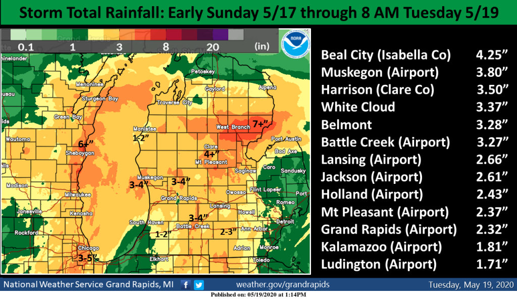
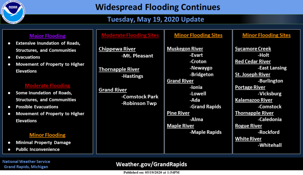
There is major flooding going on today in Midland. Two dams broke on the Tittabawassee River. The Tittabawassee River in Midland is 34.72 feet at 8:45 a.m. The flood stage is 24 feet. The river is projected to crest at 38 feet at midnight Wednesday night, according to the NWS. However, city officials expect the river to crest sooner than that, at 8 p.m. Wednesday. M-20 is closed between Main Street and Meridian in both directions. The M-30 bridge near Stryker’s Lakeside Marina is washed out. U.S. 10 was closed in Sanford. I take M 20 thru Midland on my… Read more »
One month till the Summer solstice I love it then days start getting short again amazing our furnace kicked on this morning and only only a month away from the longest day of the year crazy bring on Fall….INDY
Back when I lived in Alpena, while not every year there were several summers when we has to have the heat on in ever month of the summer. 1965 is one year that comes to mind. In that year Aplena had lows of in June on the 2nd 35. on the 3rd 30, on the 4th 33, on the 5th 36. Then on June 14th the low was 36. On June 15 the low was 38 then on the 16th 37. Then July 6th the low was 37 on July 19 it was 39 and on July 20th if fell… Read more »
We were actually very mild the last few nights so nothing out of the ordinary for this time of year. With that said, I haven’t had to turn on the furnace in a while. My place really heats up with all the southern exposure and sun. Get ready for that AC!
From April 9th to May 19th there have only been 6 days with the mean temperature above average. So it has been a very cold mid spring. But then the upper 70’s to low 80’s will fell very warm after all of that cold we have just had.
Slim
The last 5 days have averaged only 1 degree off average cumulatively, so my point that it hasn’t been bad at all lately. And is about to get very warm!
We are in the last 3rd of May so I would expect for to get warm. The average H/L today is 71/49 and that goes up to 73/51 by next Wednesday and by the 31st it is up to 74/53 so it is now time for it to warm up. At this time I do not see any record cold or warm temperatures in the next week or so.
Slim
Thanks to a continuation of our mild overnight temps, yesterday was only -1 below average. It looks like today or tomorrow will likely begin our long streak of above average days into the foreseeable future!